Metropolis, Illinois

Last updated

Metropolis, Illinois
Curtis House Metropolis IL.JPG
Elijah P. Curtis House in Metropolis
Massac County Illinois Incorporated and Unincorporated areas Metropolis Highlighted.svg
Location in Massac County, Illinois
Coordinates: 37°9′12″N88°43′31″W / 37.15333°N 88.72528°W / 37.15333; -88.72528
CountryUnited States
StateIllinois
County Massac
Area
[1]
  Total6.16 sq mi (15.96 km2)
  Land6.02 sq mi (15.59 km2)
  Water0.14 sq mi (0.37 km2)
Elevation
360 ft (110 m)
Population
 (2020) [2]
  Total5,969
  Density991.53/sq mi (382.84/km2)
Time zone UTC−6 (CST)
  Summer (DST) UTC−5 (CDT)
ZIP code
62960
Area code 618
FIPS code 17-48645
Website www.metropolisil.gov

Metropolis is a city and the county seat in Massac County, Illinois, United States. It is located by the Ohio River. As of the 2020 census, it had a population of 5,969, [2] down from 6,537 in 2010. [3] Metropolis is part of the Paducah, KY-IL Metropolitan Statistical Area in Southern Illinois.

Contents

History

Located on the Ohio River, the Metropolis area has been settled by many different peoples throughout history. For thousands of years, varying cultures of Native Americans populated the area. The most complex society was the Mississippian culture, which reached its peak around AD 1100 and built a large city at Cahokia, near the Mississippi River and present-day Collinsville, Illinois, to the north opposite St. Louis, Missouri. Its people built large earthworks and related structures, many of which have been preserved and protected at the UNESCO World Heritage Site. Mississippian culture regional centers arose throughout the Ohio and lower Mississippian valleys, where the rivers were part of widespread trading routes used for exchange with other cultures.

In 1757, Massac County was settled by a French expedition, which built Fort de L'Ascension for use during the French and Indian War against the British (the war is also known as the Seven Years' War, which took place largely in Europe). The garrison at the fort was able to resist a Cherokee attack during the war. Afterward the defeated French abandoned the fort, and many moved west of the Mississippi River to escape British rule. When the victorious British colonists arrived to take control of territory ceded by the French, the Chickasaw had already destroyed the fort.

During the American Revolutionary War, the mostly ethnic French residents of the town were sympathetic to the rebels. Afterward in 1794, President George Washington ordered Fort Massac reconstructed, at a strategic site high above the Ohio River. The fort was severely damaged by the 1811–12 New Madrid earthquakes. Rather than rebuild, the US military abandoned the facility in 1814, as its forces were needed further west. Local settlers scavenged the timbers and left little behind of the original construction materials.

This section of the state was largely settled by migrants from the Upper South, and many brought slaves with them. It was years after Illinois was admitted as a free state that all such slaves gained their freedom.

The city of Metropolis was founded in 1839 near the site of Fort Massac by a merchant from Pittsburgh and a local land owner; the two envisioned that the location on the Ohio River would become a transport hub and chose a befittingly grand name. [4] In 1843, the Illinois Legislature formed Massac County. The McCartney family became leaders in building the town of Metropolis.

During the early years of the American Civil War, soldiers were encamped in the vicinity. Although Illinois was established as a free state, this section had many southern sympathizers. Despite this background, the state stayed with the Union during the war.

1850 map showing the proposed "Western District of Columbia" spanning the Ohio River at Metropolis. Modern maps do not show a "Capitol City" on the Kentucky side. 1850 IC.jpg
1850 map showing the proposed "Western District of Columbia" spanning the Ohio River at Metropolis. Modern maps do not show a "Capitol City" on the Kentucky side.

Prior to the American Civil War, some groups worked to establish a Western District of Columbia, to include present-day Metropolis and the nearby area of Kentucky. An 1850 map illustrates this proposal.

During the twentieth century, agriculture has continued to be the economic driver of the region. The state's authorization of riverboat gambling led to Metropolis's becoming the site of the Harrah's Metropolis casino/hotel, a riverboat casino frequented by visitors from around the region. Tourism is one of the city's largest industries.[ citation needed ]

Metropolis is also the site of the Honeywell Uranium Hexafluoride Processing Facility, which converts milled uranium into uranium hexafluoride for nuclear reactors. [5]

Geography

Metropolis is located in southern Massac County at 37°9′12″N88°43′31″W / 37.15333°N 88.72528°W / 37.15333; -88.72528 (37.153332, -88.725374), [6] on the north shore of the Ohio River. It is bordered to the south, across the river, by McCracken County, Kentucky. Paducah, Kentucky, is 13 miles (21 km) to the southeast.

According to the U.S. Census Bureau, Metropolis has a total area of 6.16 square miles (15.95 km2), of which 6.02 square miles (15.59 km2) are land and 0.14 square miles (0.36 km2), or 2.30%, are water. [1]

Demographics

Historical population
CensusPop.Note
1860 1,098
1870 2,490126.8%
1880 2,6687.1%
1890 3,57333.9%
1900 4,00912.2%
1910 4,65516.1%
1920 5,0558.6%
1930 5,57310.2%
1940 6,28712.8%
1950 6,093−3.1%
1960 7,33920.4%
1970 6,940−5.4%
1980 7,1713.3%
1990 6,734−6.1%
2000 6,482−3.7%
2010 6,5370.8%
2020 5,969−8.7%
U.S. Decennial Census [7]

As of the census [8] of 2000, there were 6,482 people, 2,896 households, and 1,708 families residing in the city. The population density was 1,295.1 inhabitants per square mile (500.0/km2). There were 3,265 housing units at an average density of 652.3 per square mile (251.9/km2). The racial makeup of the city was 90.53% White, 7.61% African American, 0.20% Native American, 0.20% Asian, 0.45% from other races, and 1.02% from two or more races. Hispanic or Latino of any race were 0.74% of the population.

There were 2,896 households, out of which 24.4% had children under the age of 18 living with them, 43.6% were married couples living together, 11.9% had a female householder with no husband present, and 41.0% were non-families. 36.9% of all households were made up of individuals, and 20.0% had someone living alone who was 65 years of age or older. The average household size was 2.13 and the average family size was 2.77.

In the city the population was spread out, with 20.0% under 18, 7.8% from 18 to 24, 25.4% from 25 to 44, 21.9% from 45 to 64, and 24.8% ages 65 or older. The median age was 43 years. For every 100 females, there were 79.5 males. For every 100 females age 18 and over, there were 75.0 males.

The median income for a household in the city was $25,371, and the median income for a family was $33,979. Males had a median income of $27,630 versus $17,561 for females. The per capita income for the city was $15,967. About 12.5% of families and 17.2% of the population were below the poverty line, including 21.8% of those under age 18 and 16.7% of those age 65 or over.

Transportation

View up Market Street in 2022 Metropolis IL 2022c.jpg
View up Market Street in 2022
The Metropolis Bridge in 2022 Metropolis Bridge 2022b.jpg
The Metropolis Bridge in 2022

Metropolis is served by Interstate 24, which runs from Chattanooga, Tennessee, northwest to Williamson County, Illinois, where it connects with Interstate 57. U.S. Route 45 passes through the center of Metropolis as East 5th Street, Ferry Street, and West 10th Street. US 45 runs geographically east–west through the area but runs north to Chicago and south to Paducah and is signed north–south.

Illinois Route 145 lies east of the city and serves remote areas of nearby Shawnee National Forest.

Metropolis is served by the Paducah & Illinois Railroad, jointly owned by Canadian National Railway, BNSF Railway, and the Paducah & Louisville Railway, crossing the Ohio River on the Metropolis Bridge.

Healthcare

Metropolis is home to Massac Memorial Hospital, a 25-bed critical access hospital that opened in 1956. Originally shaped like a cross, the hospital is located on the northwest side of town. The hospital has undergone several renovations and additions to make updates to the original facility. Current services offered include ambulance, cardiac rehabilitation, cardiopulmonary, emergency department, imaging, laboratory, Massac Memorial Medical Clinic, rehabilitation services, sleep disorders center, specialty clinic, surgery, and transitional care. [9] A Fresenius Medical Care dialysis center was constructed on the campus and opened in 2009. [10]

Superman's "hometown"

The Massac County Courthouse with Superman statue (left) and Superman Museum (right) Metropolis IL 2022b.jpg
The Massac County Courthouse with Superman statue (left) and Superman Museum (right)

In his various portrayals, Superman resides in a fictional American city named Metropolis, and on June 9, 1972, the Illinois State Legislature passed Resolution 572, declaring Metropolis the "Hometown of Superman". [11]

The city has a 15-foot-tall (4.6 m) painted bronze statue of Superman which sits in front of the county courthouse, and a statue of Noel Neill's Lois Lane from The Adventures of Superman stands just a few blocks away.

Each year on the second weekend of June, Superman fans from all over the world gather in Metropolis [12] for their annual Superman Celebration, which features celebrity guests from movies, television, and the comic book industry.

The four-day annual celebration also boasts vendors selling food, comics, homemade crafts, and other merchandise, as well as discussion panels, auctions, a costume contest, and a variety of other events throughout the weekend. The first such celebration was organized by local civic clubs and took place in June 1979. [13]

The local newspaper is named The Metropolis Planet , inspired by The Daily Planet , the fictional paper in the Superman comics and other Superman media. [14]

The real town of Metropolis is portrayed in one Superman comic-book story, "Superman #92", in a story titled "Massacre in Metropolis!" (which is continued into "Adventures of Superman #515"), as a town whose citizens idolize what is to them the real-life Man of Steel. A villain named Massacre arrives in the town, having gotten lost and thinking he was in the "other" Metropolis, the large city where Superman actually lives. He attacks a security guard and threatens many citizens in order to get proper directions to Superman's Metropolis.[ citation needed ]

Metropolis water tower with "Home of Superman" on the side WaterTowerMetropolisIL.jpg
Metropolis water tower with "Home of Superman" on the side

Notable people

See also

Related Research Articles

<span class="mw-page-title-main">McCracken County, Kentucky</span> County in Kentucky, United States

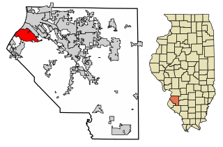
McCracken County is a county located in the far west portion of U.S. state of Kentucky. As of the 2020 census, the population was 67,875. The county seat and only municipality is Paducah. McCracken County was the 78th county formed in the state, having been created in 1825. It is part of the historic Jackson Purchase, territory sold by the Chickasaw people to General Andrew Jackson and Governor Isaac Shelby; this territory was located at the extreme western end of Kentucky.

<span class="mw-page-title-main">Tipton County, Tennessee</span> County in Tennessee, United States

Tipton County is a county located on the western end of the U.S. state of Tennessee, in the Mississippi Delta region. As of the 2020 census, the population was 60,970. Its county seat is Covington. Tipton County, founded in 1823, is part of the Memphis, TN-MS-AR Metropolitan Statistical Area.

<span class="mw-page-title-main">Livingston County, Kentucky</span> County in Kentucky, United States

Livingston County is a county located in the U.S. state of Kentucky. As of the 2020 census, the population was 8,888. Its county seat is Smithland and its largest community is Ledbetter. The county was established in 1798 from land taken from Christian County and is named for Robert R. Livingston, a member of the Committee of Five that drafted the U.S. Declaration of Independence. The county was strongly pro-Confederate during the American Civil War and many men volunteered for the Confederate Army. Livingston County is part of the Paducah, KY-IL Metropolitan Statistical Area. It is a prohibition or dry county with the exception of Grand Rivers which voted to allow alcohol sales in 2016.

<span class="mw-page-title-main">Pulaski County, Illinois</span> County in Illinois, United States

Pulaski County is a county located in the U.S. state of Illinois. According to the 2020 census, it had a population of 5,193. Its county seat is Mound City. Its largest city is Mounds. It is located along the Ohio River in the southwestern portion of the state, known locally as "Little Egypt".

<span class="mw-page-title-main">Pope County, Illinois</span> County in Illinois, United States

Pope County is the southeasternmost county in the U.S. state of Illinois. According to the 2020 census, it had a population of 3,763, making it the second-least populous county in Illinois. Its county seat is Golconda. The county was organized in 1816 from portions of Gallatin and Johnson counties and named after Nathaniel Pope, a politician and jurist from the Illinois Territory and State of Illinois.

<span class="mw-page-title-main">Massac County, Illinois</span> County in Illinois, United States

Massac County is a county in the U.S. state of Illinois. According to the 2020 census, it had a population of 14,169. Established in 1843 and named for a French fort founded in the 18th century, its county seat is Metropolis. Massac County is included in the Paducah, KY-IL Metropolitan Statistical Area. It is located along the Ohio River, in the portion of the state known locally as "Little Egypt".

<span class="mw-page-title-main">Old Shawneetown, Illinois</span> Village in Illinois, United States

Old Shawneetown is a village in Gallatin County, Illinois, United States. As of the 2020 census, the village had a population of 113, down from 193 at the 2010 census. Located along the Ohio River, Shawneetown served as an important United States government administrative center for the Northwest Territory. The village was devastated by the Ohio River flood of 1937. The village's population was moved several miles inland to New Shawneetown.

<span class="mw-page-title-main">Cave-In-Rock, Illinois</span> Village in Illinois, United States

Cave-In-Rock is a village in Hardin County, Illinois, United States. Its principal feature and tourist attraction is nearby Cave-In-Rock, on the banks of the Ohio River. In 1816, the earliest known permanent white settlers arrived and started building a town near the cave. The town was originally known as Rock and Cave, Illinois, with a post office under this name. On October 24, 1849, the town was officially renamed Cave-In-Rock. Cave-In-Rock was incorporated as a village in 1901. The population was 318 at the 2010 census.

<span class="mw-page-title-main">Brookport, Illinois</span> City in Illinois, United States

Brookport is a city in Massac County, Illinois, United States. The population was 725 at the 2020 census, down from 984 in 2010. It is part of the Paducah, KY-IL Metropolitan Statistical Area.

<span class="mw-page-title-main">Joppa, Illinois</span> Village in Illinois, United States

Joppa is a village in Massac County, Illinois, United States, along the Ohio River. The population was 350 as of the 2020 census. It is part of the Paducah, KY-IL Metropolitan Statistical Area.

<span class="mw-page-title-main">Mound City, Illinois</span> City in Illinois, United States

Mound City is a city and the county seat of Pulaski County, Illinois, United States. It is located along the Ohio River just north of its confluence with the Mississippi River. As of the 2010 census, the city population was 588.

<span class="mw-page-title-main">Cahokia, Illinois</span> Village in the United States

Cahokia is a settlement and former village in St. Clair County, Illinois, United States, founded as a colonial French mission in 1689. Located east of the Mississippi River in the Greater St. Louis metropolitan area, as of the 2010 census, 15,241 people lived in the village. On May 6, 2021, the village was incorporated into the new city of Cahokia Heights.

<span class="mw-page-title-main">Wickliffe, Kentucky</span> City in Kentucky, United States

Wickliffe is a home rule-class city and the county seat of Ballard County, Kentucky, United States. The population was 670 at the 2020 census.

<span class="mw-page-title-main">Carrsville, Kentucky</span> City in Kentucky, United States

Carrsville is a home rule-class city beside the Ohio River in Livingston County, Kentucky, in the United States. The population was 50 at the 2010 census, declining from 64 as of 2000. It is part of the Paducah, KY-IL Metropolitan Statistical Area. It is situated just west of the junction of where Buck Creek empties into the Ohio River.

<span class="mw-page-title-main">Massac, Kentucky</span> Census-designated place in Kentucky, United States

Massac is a census-designated place (CDP) in McCracken County, Kentucky, United States. The population was 4,635 at the 2020 census. It is part of the Paducah, KY-IL Metropolitan Statistical Area.

<span class="mw-page-title-main">Paducah, Kentucky</span> City in Kentucky, United States

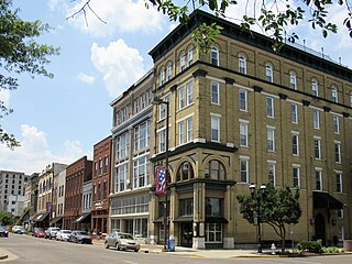
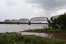
Paducah is a home rule-class city in and the county seat of McCracken County, Kentucky, United States. The largest city in the Jackson Purchase region, it is located in the Southeastern United States at the confluence of the Tennessee and the Ohio rivers, halfway between St. Louis, Missouri, to the northwest and Nashville, Tennessee, to the southeast. As of the 2020 census, the population was 27,137, up from 25,024 in 2010. Twenty blocks of the city's downtown have been designated as a historic district and listed on the National Register of Historic Places.

<span class="mw-page-title-main">Maumee, Ohio</span> City in Ohio, United States

Maumee is a city in Lucas County, Ohio, United States. Located along the Maumee River, it is a suburb about 10 miles (16 km) southwest of Toledo. The population was 13,896 at the 2020 census. Maumee was declared an All-America City by the National Civic League in June 2006.

<span class="mw-page-title-main">Upper Sandusky, Ohio</span> City in Ohio, United States

Upper Sandusky is a city in and the county seat of Wyandot County, Ohio, United States, along the upper Sandusky River. The city lies approximately 59 miles (95 km) south of Toledo and 62 miles (100 km) north of Columbus. The population was 6,698 at the 2020 census.

<span class="mw-page-title-main">Fort Atkinson, Wisconsin</span> City in Wisconsin, United States

Fort Atkinson is a city in Jefferson County, Wisconsin, United States. It is on the Rock River, a few miles upstream from Lake Koshkonong. The population was 12,579 at the 2020 census. Fort Atkinson is the largest city located entirely in Jefferson County, as Watertown is split between Jefferson and Dodge counties. Fort Atkinson is a principal city of the Fort Atkinson-Watertown micropolitan statistical area which is in turn a sub-market of the larger Milwaukee-Waukesha-Racine CSA.

<span class="mw-page-title-main">Paducah metropolitan area</span> Metropolitan Area in Western Kentucky

The Paducah, KY–IL Metropolitan Statistical Area, as defined by the United States Census Bureau, is an area consisting of five counties – three in the Jackson Purchase region of Kentucky, a fourth Kentucky county bordering the Purchase, and one in Southern Illinois – anchored by the city of Paducah, Kentucky. The Paducah KY-IL Micropolitan Statistical Area was upgraded to Metropolitan Statistical Area (MSA) status on July 21, 2023, by the Office of Management and Budget.. Carlisle County, Kentucky, was added to the area following the 2020 Census of the Population. The total MSA population from the 2020 United States Census was 103,486.

References

  1. 1 2 "2022 U.S. Gazetteer Files: Illinois". United States Census Bureau. Retrieved March 2, 2023.
  2. 1 2 "P1. Race – Metropolis city, Illinois: 2020 DEC Redistricting Data (PL 94-171)". U.S. Census Bureau. Retrieved March 2, 2023.
  3. "P1. Race – Metropolis city, Illinois: 2010 DEC Redistricting Data (PL 94-171)". U.S. Census Bureau. Retrieved March 2, 2023.
  4. Bragg, Michael E.; Bragg, Jon M. (2012). Metropolis. Arcadia Publishing. p. 7. ISBN   9780738593593.
  5. Dan Frosch, "In Superman's Hometown, a Labor Dispute Over Health", New York Times , August 8, 2010.
  6. "US Gazetteer files: 2010, 2000, and 1990". United States Census Bureau. February 12, 2011. Retrieved April 23, 2011.
  7. "Census of Population and Housing". Census.gov. Retrieved June 4, 2015.
  8. "U.S. Census website". United States Census Bureau . Retrieved January 31, 2008.
  9. "Massac Memorial Hospital". U.S. News & World Report. Retrieved March 5, 2012.
  10. "Massac Memorial Hospital". City of Massac. Archived from the original on February 11, 2012. Retrieved March 5, 2012.
  11. Southern Illinois Archived 2007-09-28 at the Wayback Machine
  12. "Superman Celebration - About Us".
  13. Van Hyning, Thomas E. (1986). "Southern Illinois entices vacationers". Illinois Parks and Recreation. 17 (3). Illinois Park and Recreation Society.
  14. Weintraub, Boris (April 19, 1984). "Unusual names bestowed on a few U.S. newspapers". The Bulletin. p. 16. Retrieved May 22, 2015.
  15. Patrick J. Sauer, "Behind the Scenes Companies: At the Heart of Everyday Life", Inc. Magazine, 1 Oct 2008, accessed 14 Dec 2010