Cambridge | |
---|---|
Coordinates: 41°18′12″N90°11′36″W / 41.30333°N 90.19333°W | |
Country | United States |
State | Illinois |
County | Henry |
Township | Cambridge |
Government | |
• Type | Village Board |
• Village President | Jason Gustafson |
Area | |
• Total | 2.00 sq mi (5.19 km2) |
• Land | 1.99 sq mi (5.16 km2) |
• Water | 0.01 sq mi (0.04 km2) |
Population (2020) | |
• Total | 2,086 |
• Density | 1,047.71/sq mi (404.43/km2) |
Time zone | UTC-6 (CST) |
• Summer (DST) | UTC-5 (CDT) |
ZIP Code | 61238 |
Area code | 309 |
FIPS code | 17-10643 |
Wikimedia Commons | Cambridge, Illinois |
Website | www |
Cambridge is a village and the county seat of Henry County, Illinois, United States. The population was 2,160 at the 2010 census, down from 2,180 in 2000. [2]
Before 1843, the land where Cambridge is currently located was the private property of a man named Rev. Ithamar Pillsbury, who was very well known amongst the Yankee settlers (migrants from New England and upstate New York who were descended from the English Puritans who settled New England in the 1600s) who were moving to Henry County in large numbers at that time. Reverend Pillsbury deeded a large portion of his land to the town council and they immediately agreed it was a good place to lay out a town. Lots were sold to incoming migrants and on June 9, 1843 (after some quarreling among the town founders about how to finance it) construction began on the town. Roads were laid out, post routes established, public buildings erected and people were invited to move there. The original settlers were almost entirely of New England origins or were Yankees from upstate New York whose families had moved to that place from New England only one generation earlier, in the aftermath of the Revolutionary War. This resulted in Henry County being culturally very contiguous with early New England culture. [3] [4]
According to the 2010 census, Cambridge has a total area of 2.154 square miles (5.58 km2), of which 2.14 square miles (5.54 km2) (or 99.35%) is land and 0.014 square miles (0.04 km2) (or 0.65%) is water. [5]
Census | Pop. | Note | %± |
---|---|---|---|
1880 | 1,203 | — | |
1890 | 940 | −21.9% | |
1900 | 1,345 | 43.1% | |
1910 | 1,272 | −5.4% | |
1920 | 1,335 | 5.0% | |
1930 | 1,355 | 1.5% | |
1940 | 1,312 | −3.2% | |
1950 | 1,489 | 13.5% | |
1960 | 1,665 | 11.8% | |
1970 | 2,095 | 25.8% | |
1980 | 2,217 | 5.8% | |
1990 | 2,124 | −4.2% | |
2000 | 2,180 | 2.6% | |
2010 | 2,160 | −0.9% | |
2020 | 2,086 | −3.4% | |
U.S. Decennial Census [6] |
At the 2000 census there were 2,180 people, 856 households, and 595 families in the village. The population density was 1,540.2 inhabitants per square mile (594.7/km2). There were 896 housing units at an average density of 633.0 per square mile (244.4/km2). The racial makeup of the village was 98.17% White, 0.78% African American, 0.18% Native American, 0.32% Asian, 0.05% Pacific Islander, and 0.50% from two or more races. Hispanic or Latino of any race were 0.46%. [7]
Of the 856 households 31.5% had children under the age of 18 living with them, 57.5% were married couples living together, 8.9% had a female householder with no husband present, and 30.4% were non-families. 26.2% of households were one person and 14.0% were one person aged 65 or older. The average household size was 2.45 and the average family size was 2.95.
The age distribution was 24.6% under the age of 18, 9.8% from 18 to 24, 27.9% from 25 to 44, 21.7% from 45 to 64, and 15.9% 65 or older. The median age was 38 years. For every 100 females, there were 101.7 males. For every 100 females age 18 and over, there were 99.0 males.
The median household income was $38,636 and the median family income was $46,786. Males had a median income of $31,442 versus $20,129 for females. The per capita income for the village was $17,842. About 8.1% of families and 10.3% of the population were below the poverty line, including 16.5% of those under age 18 and 4.9% of those age 65 or over. 2010 Census According to the 2020 census, the population was 2,086. Of this, 2,077 (96.16%) were White, 35 (1.62%) were black or African American, 26 (1.20%) were two or more races, 13 (0.60%) were Asian, 7 (0.32) were American Indian or Alaska Native, 2 (0.09%) were some other race. 45 (2.08%) were Hispanic or Latino (of any race) [8]
As the county seat of Henry County, Illinois, Cambridge hosts the county government. The Henry County Court House, designed by Thomas J. Tolan & Son, Architects, of Fort Wayne, Indiana (1875–1878), is the key architectural landmark of the village. The courthouse was listed on the National Register of Historic Places in 2004.
Cambridge has a single school district, School District #227, which includes a single elementary school, junior high (attached to the high school), and high school. [9] The high school graduates around 50-60 students annually. Like many small towns, the cultural life of the community revolves around the arts and sports related to the school. The elementary school was selected as a 2006 Blue Ribbon School, part of the No Child Left Behind Act. It was one of only 18 selected in Illinois. [10]
Historically, Cambridge has been linked to nearby Bishop Hill, Illinois. Bishop Hill was founded in 1846 by a sect of Swedish immigrants led by their prophet, Erik Janson. For several years, local Americans and their Swedish neighbors traded and lived in peace. In 1850, Erik Janson was murdered by a former follower in the court house in Cambridge. The historic record reveals some tension between the Swedes in Bishop Hill and the residents of Cambridge. Additionally, the influx of Swedish immigrants attracted additional immigrants from Sweden to the Henry County area. As the population grew, they called for religious leadership from the Lutheran Church of Sweden, an official branch of the Swedish government.
Before they fled from Sweden, Erik Janson and his followers had a contentious break from the Lutheran Church. The Cambridge Lutheran church was established as an offshoot of Lars Paul Esbjörn's Augustana Lutheran Church in nearby Andover, Illinois. This religious-related tension would remain between the Augustana Lutherans (including Augustana College in Rock Island, Illinois) and the people of Bishop Hill well into the late 20th century. For more information on Cambridge's relationship with Bishop Hill see Troy Swanson's "Those Crazy Swedes: Outside Influence on the Bishop Hill Colony" in Nobler things to View: Collected Essays on the Erik-Janssonists published by the Bishop Hill Heritage Association in 1998.
Dickey County is a county in the U.S. state of North Dakota. As of the 2020 census, the population was 4,999. Its county seat is Ellendale.
Henry County is a county located in the U.S. state of Illinois. The 2020 United States Census, listed its population at 49,284. Its county seat is Cambridge.
Aviston is a village in Clinton County, Illinois, United States. The population was 2,340 at the 2020 census, up from 1,945 at the 2010 census.
Barrington Hills is a village located about 40 miles (64 km) northwest of Chicago in the U.S. state of Illinois. Per the 2020 census, the population was 4,114. It straddles approximately 29 square miles (75 km2) over four counties, Cook, Kane, Lake, and McHenry. The Village of Barrington Hills was incorporated in 1957.
Burr Ridge is a village in Cook and DuPage counties in the U.S. state of Illinois. Per the 2020 census, the population was 11,192.
Willow Springs is a village in Cook County, Illinois, with a small portion in DuPage County. The village was founded in 1892, and was named for the springs along the Des Plaines River. In 2020, the population was 5,857.
Cuba is a city in Fulton County, Illinois, United States. The population was 1,184 at the 2020 census.
Andover is a village in Henry County, Illinois, United States. The population was 578 at the 2010 census, down from 594 in 2000.
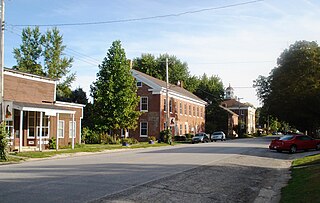
Bishop Hill is a village in Henry County, Illinois, United States, along the South Edwards River. The population was 128 at the 2010 census, up from 125 in 2000. It is the home of the Bishop Hill State Historic Site, a park operated by the Illinois Historic Preservation Agency.
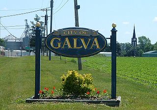
Galva is a city in Henry County, Illinois, United States. The population was 2,589 at the 2010 census, down from 2,758 in 2000.
Campbell Hill is a village in Jackson County, Illinois, United States. The population was 309 at the 2020 census.
Algonquin is a village in McHenry and Kane counties, Illinois, in the United States. It is a suburb of Chicago, located approximately 40 miles (64 km) northwest of the Loop. As of the 2020 census, the village's population was 29,700.
Lakemoor is a village in Lake and McHenry counties in the U.S. state of Illinois. Per the 2020 census, the population was 6,182.
The Village of Lakewood is a village in McHenry County, Illinois, United States. It was incorporated as a village on July 10, 1933. Per the 2020 census, the population was 4,283. Although commonly referred to as Lakewood, the town's proper name is preceded by 'The Village of'.
Oakwood Hills is a village in McHenry County, Illinois, United States. It was founded in 1959. The population was 2,076 at the 2020 census.
Red Bud is a city in Randolph County, Illinois, in the United States. The population was 3,804 at the 2020 census.
Lyndon is a village in Whiteside County, Illinois, United States. The population was 648 at the 2010 census, up from 566 in 2000.
Crete is a village in Will County, Illinois, United States. It is a far south suburb of Chicago, 30 miles from the Loop and only 6 miles from the Indiana border. The population was 8,465 at the 2020 census. Originally named Wood's Corner, it was founded in 1836 by Vermonters Dyantha and Willard Wood.
Rich Township is one of 29 townships in Cook County, Illinois, United States located south of Chicago. As of the 2020 census, its population was 76,138. Richton Park serves as the governmental seat for the township.
Bishop Township is one of fifteen townships in Effingham County, Illinois, USA. As of the 2020 census, its population was 1,702 and it contained 629 housing units.