Mount Carroll, Illinois

Last updated

Mount Carroll, Illinois
Downtown Market Street MG 8152.jpg
Motto: 
Where we take the time to care
Carroll County Illinois Incorporated and Unincorporated areas Mount Carroll Highlighted.svg
Location of Mount Carroll in Carroll County, Illinois.
Coordinates: 42°05′44″N89°58′37″W / 42.09556°N 89.97694°W / 42.09556; -89.97694
CountryUnited States
StateIllinois
County Carroll
Named for Charles Carroll of Carrollton
Government
  MayorCarl Bates
Area
[1]
  Total2.00 sq mi (5.19 km2)
  Land2.00 sq mi (5.19 km2)
  Water0.00 sq mi (0.00 km2)
Elevation
[2]
810 ft (250 m)
Population
 (2020)
  Total1,479
  Density738.39/sq mi (285.04/km2)
Time zone UTC-6 (CST)
  Summer (DST) UTC-5 (CDT)
ZIP Code(s)
61053
Area code 815
FIPS code 17-50881
Wikimedia CommonsMount Carroll, Illinois
Website www.mtcarrollil.org

Mount Carroll is a city in and the county seat of Carroll County, Illinois, United States. The population was 1,479 at the 2020 census.

Contents

History

Carroll County Courthouse Mount Carroll courthouse.jpg
Carroll County Courthouse

Mount Carroll began life as a mill town around 1841. In 1843, a referendum moved the county seat from nearby Savanna to Mount Carroll. The town was incorporated in 1855 and became a city in 1867; the first mayor was Nathaniel Halderman, a prominent local businessman and co-founder of the mill. [3]

Shimer College was established in Mt. Carroll in 1853, but mounting debts forced a move to Waukegan in 1979 and subsequently to Chicago in 2006. The campus now is home to several organizations, most notably the Campbell Center for Historic Preservation Studies.

Geography

Mount Carroll is located slightly northwest of the center of Carroll County at 42°5′44″N89°58′37″W / 42.09556°N 89.97694°W / 42.09556; -89.97694 (42.095473, -89.977042). [4] U.S. Route 52 passes through the southern part of the city, leading east 7 miles (11 km) to Lanark and west 10 miles (16 km) to Savanna on the Mississippi River.

According to the 2021 census gazetteer files, Mount Carroll has a total area of 2.00 square miles (5.18 km2), all land. [5]

Climate

Mt. Carroll has a humid continental climate (Köppen climate classification: Dfa), with cold winters, hot summers, and four seasons. [6] Annual precipitation is about 40 inches.

Due to its elevation and northwesterly location, Mount Carroll is subject to unusually cold winter weather. From 1930 to 1999, Mount Carroll held the record for the lowest temperature ever recorded in Illinois, −35 °F (−37 °C), recorded on January 22, 1930. [7] [8] The record was beaten by Congerville in 1999, by one degree Fahrenheit. 20 years later, on January 31, 2019 during an extreme cold snap, Mount Carroll regained the title of coldest city in Illinois when a new Illinois state record low temperature of −38 °F (−39 °C) was officially recorded. [9]

Climate data for Mount Carroll, Illinois (1991–2020 normals, extremes 1897–present)
MonthJanFebMarAprMayJunJulAugSepOctNovDecYear
Record high °F (°C)61
(16)
73
(23)
85
(29)
92
(33)
104
(40)
104
(40)
108
(42)
103
(39)
99
(37)
91
(33)
79
(26)
69
(21)
108
(42)
Mean daily maximum °F (°C)30.7
(−0.7)
35.3
(1.8)
47.5
(8.6)
60.6
(15.9)
72.3
(22.4)
81.7
(27.6)
84.9
(29.4)
83.3
(28.5)
76.9
(24.9)
63.9
(17.7)
48.5
(9.2)
35.8
(2.1)
60.1
(15.6)
Daily mean °F (°C)20.8
(−6.2)
24.8
(−4.0)
36.6
(2.6)
48.2
(9.0)
59.8
(15.4)
69.4
(20.8)
72.6
(22.6)
70.7
(21.5)
63.3
(17.4)
51.1
(10.6)
38.0
(3.3)
26.4
(−3.1)
48.5
(9.2)
Mean daily minimum °F (°C)10.9
(−11.7)
14.3
(−9.8)
25.7
(−3.5)
35.8
(2.1)
47.3
(8.5)
57.0
(13.9)
60.4
(15.8)
58.1
(14.5)
49.6
(9.8)
38.3
(3.5)
27.4
(−2.6)
17.1
(−8.3)
36.8
(2.7)
Record low °F (°C)−38
(−39)
−36
(−38)
−16
(−27)
2
(−17)
15
(−9)
31
(−1)
35
(2)
32
(0)
14
(−10)
4
(−16)
−15
(−26)
−28
(−33)
−38
(−39)
Average precipitation inches (mm)1.66
(42)
1.83
(46)
2.51
(64)
3.90
(99)
4.57
(116)
5.49
(139)
4.89
(124)
3.91
(99)
3.71
(94)
3.02
(77)
2.60
(66)
2.21
(56)
40.30
(1,024)
Average snowfall inches (cm)10.2
(26)
7.9
(20)
3.6
(9.1)
0.8
(2.0)
0.0
(0.0)
0.0
(0.0)
0.0
(0.0)
0.0
(0.0)
0.0
(0.0)
0.4
(1.0)
1.7
(4.3)
8.8
(22)
33.4
(85)
Average precipitation days (≥ 0.01 in)8.97.68.911.412.711.68.98.78.68.78.19.2113.3
Average snowy days (≥ 0.1 in)5.24.21.90.30.00.00.00.00.00.20.84.717.3
Source: NOAA [10] [11]

Demographics

Historical population
CensusPop.Note
1850 462
1860 1,323186.4%
1870 1,75632.7%
1890 1,836
1900 1,9657.0%
1910 1,759−10.5%
1920 1,8062.7%
1930 1,775−1.7%
1940 1,8453.9%
1950 1,9505.7%
1960 2,0565.4%
1970 2,1434.2%
1980 1,936−9.7%
1990 1,726−10.8%
2000 1,8326.1%
2010 1,717−6.3%
2020 1,479−13.9%
U.S. Decennial Census [12]

As of the 2020 census [13] there were 1,479 people, 667 households, and 403 families residing in the city. The population density was 738.39 inhabitants per square mile (285.09/km2). There were 812 housing units at an average density of 405.39 per square mile (156.52/km2). The racial makeup of the city was 95.20% White, 0.34% African American, 0.20% Asian, 0.41% from other races, and 3.85% from two or more races. Hispanic or Latino of any race were 2.84% of the population.

There were 667 households, out of which 25.9% had children under the age of 18 living with them, 42.43% were married couples living together, 12.14% had a female householder with no husband present, and 39.58% were non-families. 36.13% of all households were made up of individuals, and 14.09% had someone living alone who was 65 years of age or older. The average household size was 2.58 and the average family size was 2.12.

The city's age distribution consisted of 19.6% under the age of 18, 9.6% from 18 to 24, 19.3% from 25 to 44, 29.9% from 45 to 64, and 21.6% who were 65 years of age or older. The median age was 46.5 years. For every 100 females, there were 77.7 males. For every 100 females age 18 and over, there were 80.2 males.

The median income for a household in the city was $54,821, and the median income for a family was $62,788. Males had a median income of $42,396 versus $30,387 for females. The per capita income for the city was $27,966. About 6.0% of families and 10.3% of the population were below the poverty line, including 19.7% of those under age 18 and 5.5% of those age 65 or over.

Arts and culture

Metcalf Hall Shimer Campus-Campbell Center Metcalf Hall Shimer Campus-Campbell CenterMG 8212.jpg
Metcalf Hall Shimer Campus-Campbell Center

Mount Carroll enjoys a remarkable concentration of historically and architecturally significant structures. The bulk of the town's downtown and older residential area are included in the Mount Carroll Historic District, which encompasses 118 acres (48 ha) and was entered into the National Register of Historic Places in 1980. Mount Carroll is also home to the Campbell Center for Historic Preservation Studies, located on the historic former Shimer College campus near the south edge of town.

The Timber Lake Playhouse, the oldest semiprofessional summer stock theater company in Illinois, is located 4 miles (6 km) southeast of Mount Carroll. The Mount Carroll post office contains an oil on canvas mural, Rural Scene - Wakarusa Valley, painted by Irene Bianucci in 1941. Federally commissioned murals were produced from 1934 to 1943 in the United States through the Section of Painting and Sculpture, later called the Section of Fine Arts, of the Treasury Department. [14]

Transportation

Notable people

Photos

Related Research Articles

<span class="mw-page-title-main">Carroll County, Illinois</span> County in Illinois, United States

Carroll County is a county located in the U.S. state of Illinois. As of the 2020 census, the population was 15,702. Its county seat is Mount Carroll.

<span class="mw-page-title-main">Loves Park, Illinois</span> City in Illinois, United States

Loves Park is a city in Boone and Winnebago counties in the U.S. state of Illinois. Most of the city is in Winnebago County, with a tiny sliver in the east located in Boone County. The population was 23,397 at the 2020 census.

<span class="mw-page-title-main">Mount Sterling, Illinois</span> City in Illinois, United States

Mount Sterling is a city in and the county seat of Brown County, Illinois, United States. The population was 2,006 at the 2020 census.

<span class="mw-page-title-main">Chadwick, Illinois</span> Village in Illinois, United States

Chadwick is a village in Carroll County, Illinois, United States. The population was 481 at the 2020 census, down from 551 at the 2010 census.

<span class="mw-page-title-main">Savanna, Illinois</span> City in Carroll County, Illinois, US

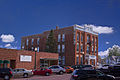
Savanna is a city in Carroll County, Illinois, United States. The population was 2,783 at the 2020 census. Savanna is located along the Mississippi River at the mouth of the Plum River.

<span class="mw-page-title-main">Robinson, Illinois</span> City in Illinois, United States

Robinson is a city in and the county seat of Crawford County, Illinois, United States. The population was 7,150 at the 2020 census, down from 7,713 at the 2010 census.

<span class="mw-page-title-main">Stockton, Illinois</span> Village in Illinois, United States

Stockton is a village in Jo Daviess County, Illinois, United States. The population was 1,862 at the 2010 census, down from 1,926 at the 2000 census.

<span class="mw-page-title-main">Indian Creek, Illinois</span> Village in Illinois, United States

Indian Creek is a village in Vernon Township, Lake County, Illinois, United States. It is part of the Chicago metropolitan area. Per the 2020 census, the population was 536. Police services are provided by Lake County Sheriff and fire/EMS services by the Countryside Fire Protection District.

<span class="mw-page-title-main">Mount Pulaski, Illinois</span> City in Illinois, United States

Mount Pulaski is a city in Logan County, Illinois, United States. The population was 1,566 at the 2010 census, and 1,481 at a 2018 estimate. It is the home of the Mount Pulaski Courthouse State Historic Site. The city is named in honor of Polish Revolutionary War hero Casimir Pulaski. Mount Pulaski has one high school: Mount Pulaski High School, home of the Hilltoppers. The school colors are purple and gold. Mount Pulaski held the county seat of Logan County from 1848 to 1855.

<span class="mw-page-title-main">Mount Morris, Illinois</span> Village in Illinois, United States

Mount Morris is a village in Mount Morris Township, Ogle County, Illinois, United States. The population was 2,998 at the 2010 census, down from 3,013 in 2000.

<span class="mw-page-title-main">Congerville, Illinois</span> Village in Illinois, United States

Congerville is a village in Woodford County, Illinois, United States. The population was 474 as of the 2010 census, up from 466 in 2000. Congerville is part of the Peoria, Illinois Metropolitan Statistical Area.

<span class="mw-page-title-main">Mount Ayr, Iowa</span> City in Iowa, United States

Mount Ayr is a city in Ringgold County, Iowa, United States. The population was 1,988 at the time of the 2020 census. It is the county seat of Ringgold County. Mount Ayr is a rural community in southwestern Iowa, 22 miles west of Interstate 35 on State Highway 2. Mount Ayr was founded in 1875 and the community was named in honor of poet Robert Burns’ birthplace in Ayr, Scotland. The “mount” was added to indicate its location on the highest point of land in the area.

<span class="mw-page-title-main">Mount Sterling, Kentucky</span> City in Kentucky, United States

Mount Sterling, often written as Mt. Sterling, is a home rule-class city in Montgomery County, Kentucky, United States. The population was 7,558 as of the 2020 census, up from 6,895 in 2010. It is the county seat of Montgomery County and the principal city of the Mount Sterling micropolitan area.

<span class="mw-page-title-main">Marion, Mississippi</span> Town in Mississippi, United States

Marion is a town in Lauderdale County, Mississippi, United States. It is a northeastern suburb of Meridian, the county seat. The population of Marion was 1,479 at the 2010 census.

<span class="mw-page-title-main">Mocksville, North Carolina</span> Town in North Carolina, United States

Mocksville is a town in Davie County, North Carolina, United States. The population was 5,900 at the 2020 census. I-40 leads west to Statesville and Hickory, and east to Winston-Salem and Greensboro. Route 64 heads east to Lexington, and west towards Statesville and Taylorsville. It is the county seat of Davie County.

<span class="mw-page-title-main">Mount Juliet, Tennessee</span> City in Tennessee, United States

Mt. Juliet is a city located in western Wilson County, Tennessee, United States. A suburb of Nashville, it is approximately 17 miles (27 km) east of downtown Nashville. Mt. Juliet is located mostly between two major national east-west routes, Interstate 40 and U.S. Route 70. As of the 2020 United States census, Mount Juliet has a population of approximately 39,289 people. Mt. Juliet is the largest city in Wilson County. The official city charter has the name listed as Mt. Juliet; however, the United States Postal Service lists its name as Mount Juliet.

<span class="mw-page-title-main">Petersburg, West Virginia</span> City in West Virginia, United States

Petersburg is a city in Grant County, West Virginia, United States. The population was 2,251 at the 2020 census. It is the county seat of Grant County.

<span class="mw-page-title-main">Mount Airy, Maryland</span> Town in Maryland

Mount Airy is a town in Carroll and Frederick counties in the U.S. state of Maryland. It is part of both the Washington Metropolitan Area and Baltimore Metropolitan Area. As of the 2010 census the population was 9,288.

<span class="mw-page-title-main">Mount Zion, Illinois</span> Village in Illinois, United States

Mount Zion is a village in Macon County, Illinois, United States. The population was 6,019 at the 2020 census.

<span class="mw-page-title-main">Savanna Township, Carroll County, Illinois</span> Township in Illinois, United States

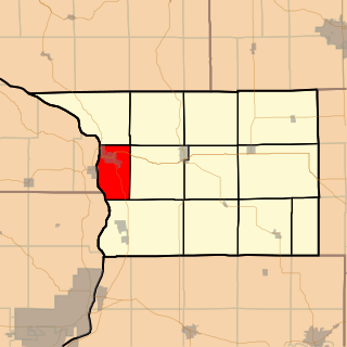
Savanna Township is one of twelve townships in Carroll County, Illinois, USA. As of the 2020 census, its population was 3,432 and it contained 1,919 housing units.

References

  1. "2020 U.S. Gazetteer Files". United States Census Bureau. Retrieved March 15, 2022.
  2. "USGS detail on Newtown" . Retrieved October 21, 2007.
  3. History of Carroll County. 1878. p. 358.
  4. "US Gazetteer files: 2010, 2000, and 1990". United States Census Bureau. February 12, 2011. Retrieved April 23, 2011.
  5. Bureau, US Census. "Gazetteer Files". Census.gov. Retrieved June 29, 2022.
  6. Peel, M. C.; Finlayson, B. L.; McMahon, T. A. "World Map of Köppen-Geiger Climate Classification". The University of Melbourne. Archived from the original on January 13, 2015. Retrieved November 26, 2014.
  7. Paul T. Hellman (2013). "Mount Carroll". Historical Gazetteer of the United States. p. 293. ISBN   978-1135948597.
  8. Hilyard, Scott (February 28, 2019). "Congerville about to lose its extreme cold state record". PJStar.com . Peoria, Illinois. Retrieved May 1, 2019.
  9. "Illinois State Record Minimum Temperature at Mt. Carroll" (PDF). National Centers for Environmental Information. National Oceanic and Atmospheric Administration. March 5, 2019. Retrieved May 1, 2019.
  10. "NowData – NOAA Online Weather Data". National Oceanic and Atmospheric Administration. Retrieved July 11, 2021.
  11. "Station: MT Carroll, IL". U.S. Climate Normals 2020: U.S. Monthly Climate Normals (1991–2020). National Oceanic and Atmospheric Administration. Retrieved July 11, 2021.
  12. "Census of Population and Housing". Census.gov. Retrieved June 4, 2015.
  13. "Explore Census Data". data.census.gov. Retrieved June 28, 2022.
  14. "Post Office Mural". livingnewdeal.org. Living New Deal. Retrieved June 13, 2016.