Stephenson County, Illinois

Last updated

Stephenson County
Stephenson County Courthouse.jpg
Map of Illinois highlighting Stephenson County.svg
Location within the U.S. state of Illinois
Illinois in United States.svg
Illinois's location within the U.S.
Coordinates: 42°21′N89°40′W / 42.35°N 89.67°W / 42.35; -89.67
CountryFlag of the United States.svg United States
StateFlag of Illinois.svg  Illinois
Founded1837
Named for Benjamin Stephenson
Seat Freeport
Largest cityFreeport
Area
  Total565 sq mi (1,460 km2)
  Land565 sq mi (1,460 km2)
  Water0.5 sq mi (1 km2)  0.09%
Population
 (2020)
  Total44,630
  Estimate 
(2023)
43,105 Decrease2.svg
  Density79/sq mi (30/km2)
Time zone UTC−6 (Central)
  Summer (DST) UTC−5 (CDT)
Congressional districts 16th, 17th
Website www.co.stephenson.il.us

Stephenson County is a county located in the U.S. state of Illinois. According to the 2020 United States Census, it had a population of 44,630. [1] Its county seat is Freeport. [2] Stephenson County is included in the Freeport, IL Micropolitan Statistical Area, which is also included in the Rockford-Freeport-Rochelle, IL Combined Statistical Area.

Contents

History

The land that became Stephenson County was first settled by William Waddams in 1832, who founded Waddams Grove. [3] By 1837, population was sufficient to form Stephenson County, taking land from Jo Daviess and Winnebago counties. The county was named for Colonel Benjamin Stephenson, an official of the Illinois Territory. [4]

Geography

According to the US Census Bureau, the county has a total area of 565 square miles (1,460 km2), of which 565 square miles (1,460 km2) is land and 0.5 square miles (1.3 km2) (0.09%) is water. [5]

Climate and weather

Freeport, Illinois
Climate chart (explanation)
J
F
M
A
M
J
J
A
S
O
N
D
 
 
1.3
 
 
25
9
 
 
1.3
 
 
31
14
 
 
2.1
 
 
43
25
 
 
3.2
 
 
57
36
 
 
4
 
 
69
47
 
 
4.5
 
 
78
57
 
 
3.6
 
 
82
62
 
 
4.1
 
 
80
59
 
 
3.7
 
 
73
50
 
 
2.6
 
 
61
39
 
 
2.7
 
 
44
28
 
 
1.7
 
 
30
16
Average max. and min. temperatures in °F
Precipitation totals in inches
Source: The Weather Channel [6]
Metric conversion
J
F
M
A
M
J
J
A
S
O
N
D
 
 
34
 
 
−4
−13
 
 
34
 
 
−1
−10
 
 
54
 
 
6
−4
 
 
82
 
 
14
2
 
 
101
 
 
21
8
 
 
113
 
 
26
14
 
 
91
 
 
28
17
 
 
104
 
 
27
15
 
 
93
 
 
23
10
 
 
66
 
 
16
4
 
 
68
 
 
7
−2
 
 
44
 
 
−1
−9
Average max. and min. temperatures in °C
Precipitation totals in mm

In recent years the average temperatures in the county seat of Freeport, have ranged from a low of 9 °F (−13 °C) in January to a high of 82 °F (28 °C) in July, although a record low of −29 °F (−34 °C) was recorded in January 2009 and a record high of 101 °F (38 °C) was recorded in July 1988. Average monthly precipitation ranged from 1.33 inches (34 mm) in January to 4.46 inches (113 mm) in June. [6]

Adjacent counties

Major highways

Demographics

Historical population
CensusPop.Note
1840 2,800
1850 11,666316.6%
1860 25,112115.3%
1870 30,60821.9%
1880 31,9634.4%
1890 31,338−2.0%
1900 34,93311.5%
1910 36,8215.4%
1920 37,7432.5%
1930 40,0646.1%
1940 40,6461.5%
1950 41,5952.3%
1960 46,20711.1%
1970 48,8615.7%
1980 49,5361.4%
1990 48,052−3.0%
2000 48,9791.9%
2010 47,711−2.6%
2020 44,630−6.5%
2023 (est.)43,105 [7] −3.4%
US Decennial Census [8]
1790–1960 [9] 1900–1990 [10]
1990–2000 [11] 2010–2013 [1]

As of the 2010 United States Census, there were 47,711 people, 19,845 households, and 13,015 families residing in the county. [12] The population density was 84.5 inhabitants per square mile (32.6/km2). There were 22,081 housing units at an average density of 39.1 per square mile (15.1/km2). [5] The racial makeup of the county was 86.5% white, 9.0% black or African American, 0.6% Asian, 0.2% American Indian, 1.2% from other races, and 2.5% from two or more races. Those of Hispanic or Latino origin made up 2.9% of the population. [12] In terms of ancestry, 46.6% were German, 12.5% were Irish, 10.0% were English, and 8.0% were American. [13]

Of the 19,845 households, 28.6% had children under the age of 18 living with them, 50.3% were married couples living together, 11.2% had a female householder with no husband present, 34.4% were non-families, and 29.7% of all households were made up of individuals. The average household size was 2.36 and the average family size was 2.90. The median age was 43.1 years. [12]

The median income for a household in the county was $43,304 and the median income for a family was $54,224. Males had a median income of $41,672 versus $29,510 for females. The per capita income for the county was $22,608. About 12.3% of families and 14.8% of the population were below the poverty line, including 24.1% of those under age 18 and 7.3% of those age 65 or over. [14]

Education

There are five public high schools and one private high Schools in the county: (approximate enrollment included)

Public high schools

Private high school

Communities

A northerly look across Stephenson County's western edge from an overlook near Kent Kent Il Scenic view3.JPG
A northerly look across Stephenson County's western edge from an overlook near Kent

City

Villages

Census-designated places

Unincorporated communities

Townships

Historic Sites

Politics

United States presidential election results for Stephenson County, Illinois [15]
Year Republican Democratic Third party
No.%No.%No.%
2020 12,52156.63%9,05540.95%5352.42%
2016 11,08354.48%7,76838.19%1,4927.33%
2012 10,51249.75%10,16548.11%4512.13%
2008 9,90945.75%11,34952.40%3991.84%
2004 12,21257.28%8,91341.81%1950.91%
2000 10,71555.29%8,06241.60%6013.10%
1996 8,87148.94%7,14539.42%2,10911.64%
1992 9,00541.58%7,89936.47%4,75221.94%
1988 11,34259.87%7,46039.38%1430.75%
1984 14,23767.37%6,72331.82%1710.81%
1980 10,77952.87%6,19530.39%3,41416.75%
1976 11,67861.02%7,19237.58%2671.40%
1972 13,58467.86%6,40431.99%310.15%
1968 11,82159.32%7,04035.33%1,0675.35%
1964 9,25246.02%10,85453.98%00.00%
1960 13,87263.07%8,05536.62%680.31%
1956 14,24569.10%6,34930.80%200.10%
1952 14,44668.51%6,60531.32%350.17%
1948 10,56458.29%7,40940.88%1490.82%
1944 11,94860.28%7,75539.13%1180.60%
1940 14,04060.92%8,91138.67%940.41%
1936 9,94346.59%10,56749.51%8323.90%
1932 8,96344.38%10,72853.11%5072.51%
1928 11,99267.97%5,57931.62%720.41%
1924 8,63853.27%2,45215.12%5,12631.61%
1920 9,57074.64%2,77221.62%4793.74%
1916 8,62058.39%5,46337.00%6814.61%
1912 3,47638.37%3,85042.49%1,73419.14%
1908 4,60550.93%4,07645.08%3603.98%
1904 4,87656.63%3,27538.03%4605.34%
1900 4,67752.49%3,98344.70%2502.81%
1896 4,72854.16%3,77643.26%2252.58%
1892 3,57446.76%3,71748.63%3524.61%

See also

Related Research Articles

<span class="mw-page-title-main">Winnebago County, Illinois</span> County in Illinois, United States

Winnebago County is a county located in the U.S. state of Illinois. According to the 2020 census, it had a population of 285,350 making it the seventh most populous county in Illinois behind Cook County and its five surrounding collar counties. Its county seat is Rockford. Winnebago County is the central county of the Rockford metropolitan area.

<span class="mw-page-title-main">Washington County, Illinois</span> County in Illinois, United States

Washington County is a county located in the U.S. state of Illinois. As of the 2020 census, it had a population of 13,761. Its county seat is Nashville. It is located in the southern portion of Illinois known locally as "Little Egypt".

<span class="mw-page-title-main">Ogle County, Illinois</span> County in Illinois, United States

Ogle County is a county in the northern part of the U.S. state of Illinois. According to the 2020 United States Census, it had a population of 51,788. Its county seat is Oregon, and its largest city is Rochelle. Ogle County comprises Rochelle, IL Micropolitan Statistical Area, which is also included in the Rockford-Freeport-Rochelle, IL Combined Statistical Area.

<span class="mw-page-title-main">Mason County, Illinois</span> County in Illinois, United States

Mason County is a county in the U.S. state of Illinois. According to the 2020 census, it had a population of 13,086. Its county seat is Havana. The county is named in honor of George Mason, a member of the Virginia legislature who campaigned for the adoption of the United States Bill of Rights.

<span class="mw-page-title-main">Lee County, Illinois</span> County in Illinois, United States

Lee County is a county located in the U.S. state of Illinois. According to the 2020 census, it has a population of 34,145. Its county seat is Dixon. The Dixon, IL Micropolitan Statistical Area includes all of Lee County.

<span class="mw-page-title-main">Carroll County, Illinois</span> County in Illinois, United States

Carroll County is a county located in the U.S. state of Illinois. As of the 2020 census, the population was 15,702. Its county seat is Mount Carroll.

<span class="mw-page-title-main">Sterling, Connecticut</span> Town in Connecticut, United States

Sterling is a town in Windham County, Connecticut, United States. The town is part of the Northeastern Connecticut Planning Region. The population was 3,578 at the 2020 census. The rural town is home to two villages: Oneco and Sterling village. Each contains a post office, a church, and a fire station. The town hall and public library are located in Oneco, and the town's one public school is in Sterling village.

<span class="mw-page-title-main">Stockton, Illinois</span> Village in Illinois, United States

Stockton is a village in Jo Daviess County, Illinois, United States. The population was 1,862 at the 2010 census, down from 1,926 at the 2000 census.

<span class="mw-page-title-main">Freeport, Illinois</span> City in Illinois, United States

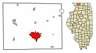
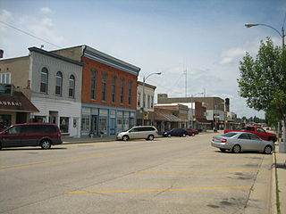
Freeport is the county seat and largest city of Stephenson County, Illinois, United States. The population was 23,973 at the 2020 census, and the mayor of Freeport is Jodi Miller, elected in 2017. Freeport is known for hosting the second Lincoln-Douglas debate of 1858, and as "Pretzel City, USA", due to a popular local German bakery that became well known for its prolific pretzel production after it opened in 1869. Freeport High School's mascot is the Pretzel to honor its heritage.

<span class="mw-page-title-main">Lena, Illinois</span> Village in Illinois, United States

Lena is a village in Stephenson County, Illinois. The population was 2,772 at the 2020 census.

<span class="mw-page-title-main">Orangeville, Illinois</span> Village in Illinois, United States

Orangeville is a village in Stephenson County, Illinois, United States. The town's sign lists the population at 800 as of January 2021. The population in 2020 was 738. The population according to the 2010 census was 793, up from 751 in 2000. Using the 2020 population of 738 Orangeville is the 741st largest city in Illinois and the 11,650th largest city in the United States. Orangeville is currently declining at a rate of -0.94% annually and its population has decreased by -6.94% since the 2010 census. The area's earliest white settlers arrived in the year 1833, and the village was platted in 1851 by John Bower, who is considered the village founder. In 1867 Orangeville was incorporated as a village. The town's central business district contains several 19th century commercial buildings, many of which were built during the railroad boom of 1888–1914. By the time the Great Depression was ongoing, business in Orangeville had started to decline, with the last bank closing in 1932. In 1956 another bank started operating in the village and is still in town today. Some recent infrastructure jumps have restored some of the village's old decor.

<span class="mw-page-title-main">Pearl City, Illinois</span> Village in Illinois, United States

Pearl City is an incorporated village in Stephenson County, Illinois, with a population of 838 at the 2010 census, up from 780 in 2000.

<span class="mw-page-title-main">Ridott, Illinois</span> Village in Illinois, United States

Ridott is a village in Stephenson County, Illinois, United States. As of the 2010 census, the village population was 164, up from 158 in 2000.

<span class="mw-page-title-main">Winslow, Illinois</span> Village in Illinois, United States

Winslow is a village in Stephenson County, Illinois. The population was 338 at the 2010 census, down from 345 in 2000.

<span class="mw-page-title-main">Pecatonica, Illinois</span> Village in Illinois, United States

Pecatonica is a village in Winnebago County, Illinois, United States. It is part of the Rockford, Illinois Metropolitan Statistical Area. The population was 2,195 at the 2010 census, up from 1,997 in 2000.

<span class="mw-page-title-main">Ridott Township, Stephenson County, Illinois</span> Township in Illinois, United States

Ridott Township is located in Stephenson County, Illinois, USA. At the 2010 census, its population was 1,451 and it contained 612 housing units. The villages of Ridott and German Valley are located in this township.

<span class="mw-page-title-main">Waddams Township, Stephenson County, Illinois</span> Township in Illinois, United States

Waddams Township is located in Stephenson County, Illinois. As of the 2010 census, its population was 807 and it contained 360 housing units. The unincorporated communities of McConnell and Damascus are located in the township, and once New Pennsylvania was located here also.

<span class="mw-page-title-main">West Point Township, Stephenson County, Illinois</span> Township in Illinois, United States

West Point Township is located in Stephenson County, Illinois. As of the 2010 census, its population was 3,369 and it contained 1,483 housing units. The village of Lena, the unincorporated community of Waddams Grove, and two former communities of Louisa and West Point were all located in this township.

Yellow Creek is a tributary of the Pecatonica River in Stephenson County, in the US state of Illinois. The 50-mile (80 km) stream also flows through a small part of Jo Daviess County. The waters of Yellow Creek were assessed for water quality in 1996, with 28 miles (45 km) being listed as "fair" and 22 miles (35 km) being listed as "good". During the 1832 Black Hawk War, the Battle of Waddams Grove was fought along Yellow Creek.

<span class="mw-page-title-main">Rockford metropolitan area, Illinois</span> Combined Statistical Area in Illinois, United States

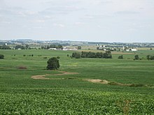
The Rockford Metropolitan Statistical Area, as defined by the United States Census Bureau, is an area consisting of four counties in north-central Illinois, anchored by the city of Rockford. As of the 2010 census, the MSA had a population of 349,431. The Rockford MSA abuts the southern portions of the Janesville-Beloit MSA and the Chicago MSA. It forms the main part of the larger Rockford–Freeport–Rochelle Combined Statistical Area.

References

  1. 1 2 "QuickFacts". United States Census Bureau . Retrieved January 23, 2021.
  2. "Find a County". National Association of Counties. Retrieved June 7, 2011.
  3. "Historical News". Journal of the Illinois State Historical Society. 27 (3): 347. October 1934.
  4. "Fifteenth Judicial Circuit". State of Illinois. Retrieved February 20, 2016.
  5. 1 2 "Population, Housing Units, Area, and Density: 2010 - County". US Census Bureau. Archived from the original on February 12, 2020. Retrieved July 12, 2015.
  6. 1 2 "Monthly Averages for Freeport IL". The Weather Channel. Retrieved January 27, 2011.
  7. "Annual Estimates of the Resident Population for Counties: April 1, 2020 to July 1, 2023". United States Census Bureau. Retrieved April 2, 2024.
  8. "US Decennial Census". US Census Bureau. Retrieved July 8, 2014.
  9. "Historical Census Browser". University of Virginia Library. Retrieved July 8, 2014.
  10. "Population of Counties by Decennial Census: 1900 to 1990". US Census Bureau. Retrieved July 8, 2014.
  11. "Census 2000 PHC-T-4. Ranking Tables for Counties: 1990 and 2000" (PDF). US Census Bureau. Retrieved July 8, 2014.
  12. 1 2 3 "Profile of General Population and Housing Characteristics: 2010 Demographic Profile Data". US Census Bureau. Archived from the original on February 13, 2020. Retrieved July 12, 2015.
  13. "Selected Social Characteristics in the United States – 2006-2010 American Community Survey 5-Year Estimates". US Census Bureau. Archived from the original on February 13, 2020. Retrieved July 12, 2015.
  14. "Selected Economic Characteristics – 2006-2010 American Community Survey 5-Year Estimates". US Census Bureau. Archived from the original on February 13, 2020. Retrieved July 12, 2015.
  15. Leip, David. "Atlas of US Presidential Elections". uselectionatlas.org.

42°21′N89°40′W / 42.35°N 89.67°W / 42.35; -89.67