DeWitt County | |
---|---|
Coordinates: 40°10′29″N88°54′15″W / 40.17463°N 88.90409°W | |
Country | United States |
State | Illinois |
Founded | 1839 |
Named for | DeWitt Clinton |
Seat | Clinton |
Largest city | Clinton |
Area | |
• Total | 405 sq mi (1,050 km2) |
• Land | 398 sq mi (1,030 km2) |
• Water | 7.6 sq mi (20 km2) 1.9% |
Population (2020) | |
• Total | 15,516 |
• Density | 38/sq mi (15/km2) |
Time zone | UTC−6 (Central) |
• Summer (DST) | UTC−5 (CDT) |
Congressional district | 15th |
Website | www |
DeWitt County is a county located in the U.S. state of Illinois. As of the 2020 census, the population was 15,516. [1] Its county seat is Clinton. [2] The county was formed on March 1, 1839, from Macon and McLean counties. The county was named in honor of the seventh Governor of New York State, DeWitt Clinton. [3]
DeWitt County is included in Bloomington–Normal, IL Metropolitan Statistical Area.
The U.S. Census Bureau and the U.S. Geological Survey (USGS) list the county's name as De Witt, although the county uses the name DeWitt (no space).
According to the U.S. Census Bureau, the county has a total area of 405 square miles (1,050 km2), of which 398 square miles (1,030 km2) is land and 7.6 square miles (20 km2) (1.9%) is water. [4]
Clinton, Illinois | ||||||||||||||||||||||||||||||||||||||||||||||||||||||||||||
---|---|---|---|---|---|---|---|---|---|---|---|---|---|---|---|---|---|---|---|---|---|---|---|---|---|---|---|---|---|---|---|---|---|---|---|---|---|---|---|---|---|---|---|---|---|---|---|---|---|---|---|---|---|---|---|---|---|---|---|---|
Climate chart (explanation) | ||||||||||||||||||||||||||||||||||||||||||||||||||||||||||||
| ||||||||||||||||||||||||||||||||||||||||||||||||||||||||||||
|
In recent years, average temperatures in the county seat of Clinton have ranged from a low of 17 °F (−8 °C) in January to a high of 88 °F (31 °C) in July, although a record low of −25 °F (−32 °C) was recorded in February 1905 and a record high of 113 °F (45 °C) was recorded in July 1954. Average monthly precipitation ranged from 1.95 inches (50 mm) in February to 4.54 inches (115 mm) in July. [5]
Census | Pop. | Note | %± |
---|---|---|---|
1840 | 3,247 | — | |
1850 | 5,002 | 54.0% | |
1860 | 10,820 | 116.3% | |
1870 | 14,768 | 36.5% | |
1880 | 17,010 | 15.2% | |
1890 | 17,011 | 0.0% | |
1900 | 18,972 | 11.5% | |
1910 | 18,906 | −0.3% | |
1920 | 19,252 | 1.8% | |
1930 | 18,598 | −3.4% | |
1940 | 18,244 | −1.9% | |
1950 | 16,894 | −7.4% | |
1960 | 17,253 | 2.1% | |
1970 | 16,975 | −1.6% | |
1980 | 18,108 | 6.7% | |
1990 | 16,516 | −8.8% | |
2000 | 16,798 | 1.7% | |
2010 | 16,561 | −1.4% | |
2020 | 15,516 | −6.3% | |
2023 (est.) | 15,365 | [6] | −1.0% |
U.S. Decennial Census [7] 1790-1960 [8] 1900-1990 [9] 1990-2000 [10] 2010 [11] |
As of the 2010 United States Census, there were 16,561 people, 6,811 households, and 4,618 families residing in the county. [12] The population density was 41.7 inhabitants per square mile (16.1/km2). There were 7,521 housing units at an average density of 18.9 per square mile (7.3/km2). [4] The racial makeup of the county was 96.8% white, 0.5% black or African American, 0.4% Asian, 0.2% American Indian, 0.9% from other races, and 1.2% from two or more races. Those of Hispanic or Latino origin made up 2.1% of the population. [12] In terms of ancestry, 31.2% were American, 21.7% were German, 15.8% were English, and 12.3% were Irish. [13]
Of the 6,811 households, 30.1% had children under the age of 18 living with them, 53.0% were married couples living together, 10.0% had a female householder with no husband present, 32.2% were non-families, and 27.5% of all households were made up of individuals. The average household size was 2.39 and the average family size was 2.88. The median age was 41.7 years. [12]
The median income for a household in the county was $45,347 and the median income for a family was $56,806. Males had a median income of $41,649 versus $27,729 for females. The per capita income for the county was $24,320. About 6.4% of families and 8.6% of the population were below the poverty line, including 12.2% of those under age 18 and 6.6% of those age 65 or over. [14]
DeWitt County is divided into thirteen townships:
DeWitt is frequently a Republican county. It has not been carried by a Democratic presidential candidate since Lyndon Johnson’s 1964 landslide, and even before that it was carried by Democrats only in strong winning elections like 1936, 1932, 1916, 1912 and 1892.
Year | Republican | Democratic | Third party | |||
---|---|---|---|---|---|---|
No. | % | No. | % | No. | % | |
2020 | 5,632 | 70.06% | 2,191 | 27.25% | 216 | 2.69% |
2016 | 5,077 | 67.19% | 1,910 | 25.28% | 569 | 7.53% |
2012 | 4,579 | 62.15% | 2,601 | 35.30% | 188 | 2.55% |
2008 | 4,348 | 55.52% | 3,308 | 42.24% | 175 | 2.23% |
2004 | 4,920 | 63.09% | 2,836 | 36.37% | 42 | 0.54% |
2000 | 3,968 | 56.28% | 2,870 | 40.70% | 213 | 3.02% |
1996 | 2,978 | 45.20% | 2,878 | 43.68% | 733 | 11.12% |
1992 | 3,164 | 40.78% | 3,009 | 38.78% | 1,586 | 20.44% |
1988 | 3,942 | 59.32% | 2,660 | 40.03% | 43 | 0.65% |
1984 | 4,534 | 65.57% | 2,352 | 34.01% | 29 | 0.42% |
1980 | 4,648 | 63.29% | 2,262 | 30.80% | 434 | 5.91% |
1976 | 4,137 | 53.97% | 3,477 | 45.36% | 52 | 0.68% |
1972 | 5,025 | 65.22% | 2,672 | 34.68% | 8 | 0.10% |
1968 | 4,247 | 54.21% | 2,823 | 36.04% | 764 | 9.75% |
1964 | 3,605 | 45.20% | 4,371 | 54.80% | 0 | 0.00% |
1960 | 5,074 | 58.40% | 3,607 | 41.51% | 8 | 0.09% |
1956 | 5,307 | 63.15% | 3,093 | 36.80% | 4 | 0.05% |
1952 | 5,212 | 61.78% | 3,221 | 38.18% | 3 | 0.04% |
1948 | 4,178 | 55.61% | 3,290 | 43.79% | 45 | 0.60% |
1944 | 4,630 | 55.40% | 3,658 | 43.77% | 69 | 0.83% |
1940 | 5,477 | 51.80% | 5,052 | 47.78% | 45 | 0.43% |
1936 | 4,544 | 44.20% | 5,676 | 55.21% | 60 | 0.58% |
1932 | 4,207 | 43.49% | 5,339 | 55.19% | 127 | 1.31% |
1928 | 6,100 | 69.40% | 2,631 | 29.93% | 59 | 0.67% |
1924 | 5,173 | 58.77% | 2,752 | 31.27% | 877 | 9.96% |
1920 | 5,001 | 60.68% | 3,079 | 37.36% | 162 | 1.97% |
1916 | 4,380 | 47.89% | 4,460 | 48.76% | 306 | 3.35% |
1912 | 1,346 | 28.49% | 1,880 | 39.79% | 1,499 | 31.72% |
1908 | 2,628 | 53.17% | 2,155 | 43.60% | 160 | 3.24% |
1904 | 2,771 | 55.96% | 1,872 | 37.80% | 309 | 6.24% |
1900 | 2,694 | 52.27% | 2,361 | 45.81% | 99 | 1.92% |
1896 | 2,587 | 51.45% | 2,370 | 47.14% | 71 | 1.41% |
1892 | 2,059 | 47.36% | 2,083 | 47.91% | 206 | 4.74% |
Clinton County is located in the U.S. state of Illinois. At the 2020 census, the population was 36,899. Its county seat is Carlyle.
Clinton County is a county located in the U.S. state of Iowa. As of the 2020 census, the population was 46,460. Its county seat is Clinton. Its name is in honor of the seventh Governor of New York State, DeWitt Clinton.
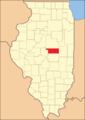
Montgomery County is a county located in the U.S. state of Illinois. According to the 2020 census, it had a population of 28,288. Its county seat is Hillsboro.
Piatt County is a county in Illinois. According to the 2020 United States Census, it had a population of 16,673. Its county seat is Monticello.
Marshall County is a county located in the U.S. state of Illinois. According to the 2020 census, it had a population of 11,742. Its county seat is Lacon.
Macon County is a county located in the U.S. state of Illinois. According to the 2020 United States Census, it had a population of 103,998. Its county seat and most populous city is Decatur.
Douglas County is a county located in the U.S. state of Illinois. As of the 2020 United States Census, the population was 19,740. The county seat is Tuscola.
DeWitt is the second largest city in Arkansas County, Arkansas, United States, which also serves as the county seat of the southern district of Arkansas County. Population was 3,292 at the time of the 2010 census. The city is located on the Arkansas Grand Prairie, known for rice farming and duck hunting. DeWitt is home to the DeWitt School District and the DeWitt Municipal Airport.
Bartelso is a village in Clinton County, Illinois, United States. The population was 635 at the 2020 census, up from 595 at the 2010 census.
Huey is a village in Clinton County, Illinois, in the United States. As of the 2020 census, the village population was 160.
Wapella is a village in DeWitt County, Illinois, United States. The population was 513 at the 2020 census.
Waynesville is a village in DeWitt County, Illinois, United States. The population was 381 at the 2020 census.
Maroa is a city in Macon County, Illinois, United States. Its population was 1,577 at the 2020 census, down from 1,801 in 2010. It is included in the Decatur, Illinois Metropolitan Statistical Area.
Clinton is a village in Lenawee County in the Irish Hills area of the U.S. state of Michigan. The population was 2,336 at the 2010 census. The village is located within Clinton Township.
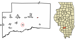
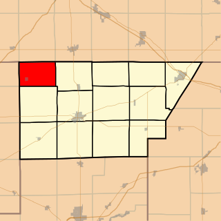
Clintonia Township is one of thirteen townships in DeWitt County, Illinois, USA. As of the 2020 census, its population was 7,315 and it contained 3,543 housing units. Clintonia Township changed its name from Clinton Township June 7, 1859.
Creek Township is one of thirteen townships in DeWitt County, Illinois, USA. As of the 2020 census, its population was 479 and it contained 203 housing units. The township contains the east half of Weldon Springs State Park.
Tunbridge Township is one of thirteen townships in DeWitt County, Illinois, USA. As of the 2020 census, its population was 751 and it contained 338 housing units.
Wapella Township is one of thirteen townships in DeWitt County, Illinois, USA. As of the 2020 census, its population was 905 and it contained 423 housing units.
Waynesville Township is one of thirteen townships in DeWitt County, Illinois, USA. As of the 2020 census, its population was 640 and it contained 303 housing units.
Wilson Township is one of thirteen townships in DeWitt County, Illinois, USA. As of the 2020 census, its population was 122 and it contained 65 housing units.