Stickney Township, Cook County, Illinois

Last updated

Stickney Township
Flag of Stickney Township, Cook County, Illinois.png
Stickney Seal.jpg
Map highlighting Stickney Township, Cook County, Illinois.svg
Location in Cook County
Map of Illinois highlighting Cook County.svg
Cook County's location in Illinois
Coordinates: 41°46′24″N87°46′07″W / 41.77333°N 87.76861°W / 41.77333; -87.76861
Country United States
State Illinois
County Cook
Established1901
Area
  Total12.67 sq mi (32.8 km2)
  Land12.48 sq mi (32.3 km2)
  Water0.19 sq mi (0.5 km2)  1.52%
Elevation
[1]
614 ft (187 m)
Population
 (2020)
  Total41,514
  Density3,300/sq mi (1,300/km2)
Time zone UTC-6 (CST)
  Summer (DST) UTC-5 (CDT)
ZIP codes
60402, 60455, 60459, 60629, 60638, 60804
FIPS code 17-031-72689
Website www.townshipofstickney.org

Stickney Township is one of 29 townships in Cook County, Illinois. As of the 2020 census, its population was 41,514, [2] with approximately 71% of that total living in the city of Burbank (pop. 29,439). [3]

Contents

Township offices are located at 5635 W. State Road in Burbank. Other municipalities in the township include Stickney (pop. 7,110) [4] and Forest View (pop. 792), [5] and the largely industrial eastern half of Bedford Park, as well as some small portions of Bridgeview. The unincorporated communities of Central Stickney and Nottingham Park are also within the township. Stickney Township's approximate borders are Pershing Road (39th Street) on the north, Cicero Avenue on the east, 87th Street on the south, and Harlem Avenue on the west, excepting those areas in the Chicago communities of Garfield Ridge and Clearing (which include Chicago Midway International Airport), but also including the area between Laramie and Cicero Avenues as far north as 35th Street, where Hawthorne Race Course is located. The Chicago Sanitary and Ship Canal, designated a National Historic District in 2011, passes through the northwest corner of the township.

Geography

According to the 2021 census gazetteer files, Stickney Township has a total area of 12.67 square miles (32.82 km2), of which 12.48 square miles (32.32 km2) (or 98.48%) is land and 0.19 square miles (0.49 km2) (or 1.52%) is water. [6]

Borders

Stickney Township is bordered on the north by Berwyn and Cicero townships, on the west by Lyons Township, and on the south by Worth Township. On the east, it is bordered by the Chicago communities of West Lawn and Ashburn, as well as portions of the Garfield Ridge and Clearing communities that separate Stickney Township's two regions. Stickney Township was originally part of Lake Township, until much of its area was annexed by the city of Chicago in 1889; afterward, the remaining area became part of Lyons Township until 1901.

Cities, towns, villages

Unincorporated towns

What became the southwest projection of the city of Chicago was within this township geographically until the area was annexed. However, small portions of the city consisting primarily of industrial districts bordered by the Stevenson Expressway to the north, 51st Street to the south and Central Avenue to the east is located in the north segment of this township. The Midway Hotel Center platted to the City of Chicago is in the northeast corner in the south segment of the township as well.

Adjacent townships

Cemeteries

A cluttered signpost at Central Avenue near I-55, noting the boundary of Central Stickney, Illinois, just southwest of Chicago Central Stickney signpost 1.jpg
A cluttered signpost at Central Avenue near I-55, noting the boundary of Central Stickney, Illinois, just southwest of Chicago

The township contains Mount Auburn Memorial Cemetery.

Major highways

Airports and landing strips

Demographics

As of the 2020 census [2] there were 41,514 people, 13,090 households, and 9,827 families residing in the township. The population density was 3,275.78 inhabitants per square mile (1,264.79/km2). There were 13,952 housing units at an average density of 1,100.92 per square mile (425.07/km2). The racial makeup of the township was 54.96% White, 2.06% African American, 1.97% Native American, 2.71% Asian, 0.04% Pacific Islander, 21.23% from other races, and 17.03% from two or more races. Hispanic or Latino of any race were 45.91% of the population.

There were 13,090 households, out of which 36.40% had children under the age of 18 living with them, 52.26% were married couples living together, 13.87% had a female householder with no spouse present, and 24.93% were non-families. 22.50% of all households were made up of individuals, and 10.70% had someone living alone who was 65 years of age or older. The average household size was 3.04 and the average family size was 3.56.

The township's age distribution consisted of 25.8% under the age of 18, 8.2% from 18 to 24, 27.4% from 25 to 44, 24.2% from 45 to 64, and 14.4% who were 65 years of age or older. The median age was 38.0 years. For every 100 females, there were 106.0 males. For every 100 females age 18 and over, there were 105.4 males.

The median income for a household in the township was $67,223, and the median income for a family was $76,811. Males had a median income of $45,313 versus $31,922 for females. The per capita income for the township was $27,536. About 7.1% of families and 10.0% of the population were below the poverty line, including 15.9% of those under age 18 and 7.2% of those age 65 or over.

Historical population
CensusPop.Note
1910 962
1920 877−8.8%
1930 2,500185.1%
1940 4,45778.3%
1950 11,079148.6%
1960 31,404183.5%
1970 41,75233.0%
1980 38,757−7.2%
1990 37,297−3.8%
2000 38,6733.7%
2010 40,7725.4%
2020 41,5141.8%
U.S. Decennial Census [7]

Education

Students south of I-55 (Stevenson Expressway) attend schools in Central Stickney School District 110 (Charles J. Sahs Elementary School) and Burbank School District 111, followed by Reavis High School. Students in the more lightly populated area north of I-55 attend schools in Lyons School District 103, then Morton West High School in Berwyn.

Politics

Since 1973, the township supervisor has been Louis Viverito of Burbank; he has also served as the township's Cook County Democratic committeeman from 1969 to February 2007, and as an Illinois state senator from 1995 to 2011.

Political districts

Notable person

Related Research Articles

<span class="mw-page-title-main">Cook County, Illinois</span> County in Illinois, United States

Cook County is the most populous county in the U.S. state of Illinois and the second-most-populous county in the United States, after Los Angeles County, California. More than 40 percent of all residents of Illinois live within Cook County. As of 2020, the population was 5,275,541. The county seat is Chicago, the most populous city in Illinois and the third most populous city in the United States. The county is at the center of the Chicago metropolitan area.

<span class="mw-page-title-main">Berwyn, Illinois</span> City in Illinois, United States

Berwyn is a suburban city in Cook County, Illinois, United States, coterminous with Berwyn Township, which was formed in 1908 after breaking off from Cicero Township. As of the 2020 census, the city had a total population of 57,250. It is part of the Chicago metropolitan area.

<span class="mw-page-title-main">Burbank, Illinois</span> City in Illinois, United States

Burbank is a city in Cook County, Illinois, United States. The population was 29,439 at the 2020 census. It borders the southwest edge of the city of Chicago; the Chicago city limit – specifically that of the Ashburn neighborhood – is in common with Burbank's eastern city limit. Burbank shares a boundary with Oak Lawn to its south, Bridgeview to its west, and Bedford Park to its north; the city of Hometown is also adjacent to Burbank's southeast corner. Burbank is less than two miles south of Chicago Midway International Airport.

<span class="mw-page-title-main">Forest View, Illinois</span> Village in Illinois, United States

Forest View is a village in Cook County, Illinois, United States. Per the 2020 census, the population was 792. It is primarily an industrial corridor adjacent to the Chicago neighborhood of Garfield Ridge, which is on the village's southern border.

<span class="mw-page-title-main">Lyons, Illinois</span> Village in Illinois, United States

Lyons is a village in Cook County, Illinois, United States. Per the 2020 census, the population was 10,817. The Chicago Portage National Historic Site is located in Lyons.

<span class="mw-page-title-main">McCook, Illinois</span> Village in Illinois, United States

McCook is a village in Cook County, Illinois, United States, and is an industrial suburb of Chicago. As of the 2020 census, the village population was 249, which is the lowest population of all municipalities in the county.

<span class="mw-page-title-main">Riverside, Illinois</span> Village in Illinois, United States

Riverside is a suburban village in Cook County, Illinois, United States. The population of the village was 9,298 at the 2020 census. It is a suburb of Chicago, located roughly 9 miles (14 km) west of downtown Chicago and 2 miles (3 km) outside city limits. A significant portion of the village is in the Riverside Landscape Architecture District, designated a National Historic Landmark in 1970.

<span class="mw-page-title-main">Stickney, Illinois</span> Village in Illinois, United States

Stickney is a village in Cook County, Illinois, United States. The village is named for Alpheus Beede Stickney, a railroad executive who played a central role in establishing the Clearing Industrial District. Per the 2020 census, the population was 7,110. It was well known in the 1920s and early 1930s as the home for several bordellos linked to mobster Al Capone's empire.

<span class="mw-page-title-main">Worth Township, Cook County, Illinois</span> Township in Illinois, United States

Worth Township is one of 29 townships in Cook County, Illinois. As of the 2020 census, its population was 152,934, with its most populous municipalities including Oak Lawn, Evergreen Park (19,943), Alsip, and Chicago Ridge. It was founded in 1849, when the county voted to subdivide itself into townships.

<span class="mw-page-title-main">Berwyn Township, Cook County, Illinois</span> Township in Illinois, United States

Berwyn Township is one of 29 townships in Cook County, Illinois, USA. As of the 2020 census, its population was 57,250, and it contained 21,037 housing units. It is coterminous with the city of Berwyn.

<span class="mw-page-title-main">Cicero Township, Cook County, Illinois</span> Township in Illinois, United States

Cicero Township is one of 29 townships in Cook County, Illinois, United States. It is coextensive with the town of Cicero. As of the 2020 census, its population was 85,268.

<span class="mw-page-title-main">Elk Grove Township, Cook County, Illinois</span> Township in Illinois, United States

Elk Grove Township is one of 29 townships in Cook County, Illinois, USA. As of the 2020 census, its population was 95,508 and it contained 40,299 housing units. Elk Grove Township formerly housed the United Airlines headquarters.

<span class="mw-page-title-main">Lyons Township, Cook County, Illinois</span> Township in Illinois, United States

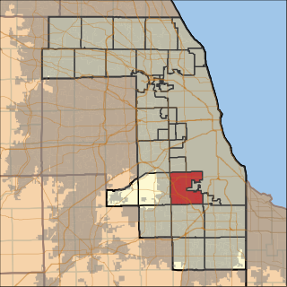
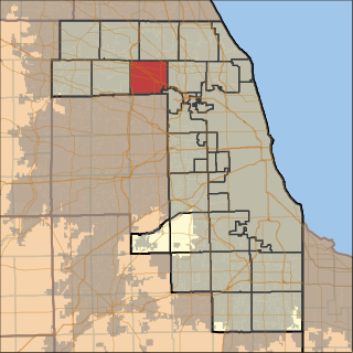
Lyons Township is one of 29 townships in Cook County, Illinois. As of the 2020 census, its population was 115,105, with its most populous municipalities including La Grange, Justice and Summit. Lyons Township was established in 1850. The village of Lyons, almost all of which lies within the township, is often confused with it.

<span class="mw-page-title-main">Orland Township, Cook County, Illinois</span> Township in Illinois, United States

Orland Township is one of 29 townships in Cook County, Illinois, USA. As of the 2020 census, its population was 98,246.

<span class="mw-page-title-main">Palos Township, Cook County, Illinois</span> Township in Illinois, United States

Palos Township is one of 29 townships in Cook County, Illinois. As of the 2020 census, its population was 56,836, with its most populous municipality being Palos Hills. The vast majority of the township's population resides in its eastern half; the half west of La Grange Road consists of the Palos Forest Preserves, a section of the Cook County Forest Preserves. In 1850 the small town of Trenton, Illinois changed its name to Palos; this recommendation was made by M.S. Powell, the local postmaster, whose ancestor supposedly sailed with Christopher Columbus from Palos de la Frontera. When it incorporated as a village in 1914, Palos officially became Palos Park. Nearby communities incorporated later: Hickory Hills, in 1951, and Palos Hills, in 1958. All three municipalities lie completely or substantially within Palos Township. Palos Heights, partially in Worth Township, incorporated in 1959.

<span class="mw-page-title-main">Proviso Township, Cook County, Illinois</span> Township in Illinois, United States

Proviso Township is one of 29 townships in Cook County, Illinois, United States. As of the 2020 census, its population was 151,209. It was organized in 1850 and originally named "Taylor", but shortly afterward its name was changed to make reference to the Wilmot Proviso, a contemporary piece of legislation intended to stop the spread of slavery.

<span class="mw-page-title-main">Rich Township, Cook County, Illinois</span> Township in Illinois, United States

Rich Township is one of 29 townships in Cook County, Illinois, United States located south of Chicago. As of the 2020 census, its population was 76,138. Richton Park serves as the governmental seat for the township.

<span class="mw-page-title-main">Riverside Township, Cook County, Illinois</span> Township in Illinois, United States

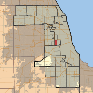
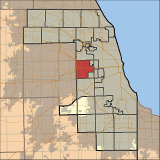
Riverside Township is one of 29 townships in Cook County, Illinois, USA. As of the 2020 census, its population was 16,664.

<span class="mw-page-title-main">Downers Grove Township, DuPage County, Illinois</span> Township in Illinois, United States

Downers Grove Township is one of nine townships in DuPage County, Illinois, US. As of the 2020 census, its population was 149,921 and it contained 61,933 housing units. It is the largest township in the county, both in terms of area and population.

Cook County Board of Commissioners 16th district is a single-member electoral district for the Cook County Board of Commissioners. It is currently represented by Frank Aguilar, a Democrat.

References

  1. U.S. Geological Survey Geographic Names Information System: Stickney Township, Cook County, Illinois
  2. 1 2 "Explore Census Data". data.census.gov. Retrieved January 22, 2023.
  3. "Explore Census Data". data.census.gov. Retrieved April 12, 2023.
  4. "Explore Census Data". data.census.gov. Retrieved April 12, 2023.
  5. "Explore Census Data". data.census.gov. Retrieved April 12, 2023.
  6. Bureau, US Census. "Gazetteer Files". Census.gov. Retrieved January 22, 2023.
  7. "Census of Population and Housing". Census.gov. Retrieved June 4, 2016.
  8. 'Illinois Blue Book 1967-1968,' Biographical Sketch of Beezhold, pg. 203-204