Burnham, Illinois

Last updated

Burnham, Illinois
Village
Village of Burnham
Burnham Seal.png
Cook County Illinois Incorporated and Unincorporated areas Burnham Highlighted.svg
Location of Burnham in Cook County, Illinois.
Illinois in United States (US48).svg
Location of Illinois in the United States
Coordinates: 41°38′8″N87°33′5″W / 41.63556°N 87.55139°W / 41.63556; -87.55139
CountryFlag of the United States (23px).png  United States
StateIllinois
County Cook
Township Thornton
Incorporated 1907
Government
  Type Council–manager
   President Robert E. Polk
Area
[1]
  Total1.94 sq mi (5.02 km2)
  Land1.85 sq mi (4.80 km2)
  Water0.09 sq mi (0.22 km2)  4.62%
Population
 (2020)
  Total4,046
  Density2,181.13/sq mi (842.19/km2)
Standard of living (2007–2011)
   Per capita income $18,234
   Median home value $143,200
ZIP code(s)
60633
Area code(s) 708
Geocode 17-09798
FIPS code 17-09798
Website https://burnham-il.gov

Burnham is a village in Cook County, Illinois, United States. The population was 4,046 at the 2020 census. [2] The ZIP code is 60633.

Contents

Burnham has a Chicago ZIP code, and is often mistakenly considered part of Chicago. It is, however, an independent municipality lying just south of the Chicago city limits.

Burnham was named for Telford Burnham who drew its plat; not, as is widely assumed, by Chicago city planner and architect Daniel Burnham.

There are two sections of Burnham. The westernmost section surrounds Torrence Avenue, a north–south street. Torrence Avenue leaves this part of Burnham via a bridge, with Chicago on the other side. The eastern section surrounds Burnham Avenue, another north–south street. This section of Burnham ends at Brainard Avenue, where the Hegewisch neighborhood of Chicago lies on the other side. Upon entering Chicago, Burnham Avenue becomes Avenue O.

Geography

Burnham is located at 41°38′8″N87°33′5″W / 41.63556°N 87.55139°W / 41.63556; -87.55139 (41.635535, -87.551284). [3]

According to the 2021 census gazetteer files, Burnham has a total area of 1.94 square miles (5.02 km2), of which 1.86 square miles (4.82 km2) (or 95.62%) is land and 0.09 square miles (0.23 km2) (or 4.38%) is water. The water section of Burnham includes part of Powderhorn Lake and its adjacent nature preserve, a unit of the Cook County Forest Preserve District. [4]

Surrounding areas

Burnham is bordered by Chicago to the north, Calumet City to the south and west, and Hammond, Indiana, to the east.

  Chicago
  Chicago Up arrow left.svg Up-1.svg Up arrow right.svg Hammond, Indiana
  Calumet City Left.svg   Right.svg Hammond, Indiana
  Calumet City Down arrow left.svg Down arrow.svg Down arrow right.svg Hammond, Indiana
  Calumet City

Demographics

Historical population
CensusPop.Note
1910 328
1920 795142.4%
1930 99425.0%
1940 865−13.0%
1950 1,33153.9%
1960 2,47886.2%
1970 3,63446.7%
1980 4,03010.9%
1990 3,916−2.8%
2000 4,1706.5%
2010 4,2060.9%
2020 4,046−3.8%
U.S. Decennial Census [5]
2010 [6] 2020 [7]

As of the 2020 census [8] there were 4,046 people, 1,607 households, and 821 families residing in the village. The population density was 2,085.57 inhabitants per square mile (805.24/km2). There were 1,589 housing units at an average density of 819.07 per square mile (316.24/km2). The racial makeup of the village was 60.43% African American, 16.58% White, 0.59% Native American, 0.30% Asian, 12.75% from other races, and 9.34% from two or more races. Hispanic or Latino of any race were 25.58% of the population.

There were 1,607 households, out of which 26.9% had children under the age of 18 living with them, 22.78% were married couples living together, 23.15% had a female householder with no husband present, and 48.91% were non-families. 46.36% of all households were made up of individuals, and 11.82% had someone living alone who was 65 years of age or older. The average household size was 3.56 and the average family size was 2.40.

The village's age distribution consisted of 23.9% under the age of 18, 5.9% from 18 to 24, 28.7% from 25 to 44, 27.7% from 45 to 64, and 13.9% who were 65 years of age or older. The median age was 38.1 years. For every 100 females, there were 101.0 males. For every 100 females age 18 and over, there were 80.0 males.

The median income for a household in the village was $46,382, and the median income for a family was $46,890. Males had a median income of $54,931 versus $27,141 for females. The per capita income for the village was $24,430. About 15.3% of families and 15.4% of the population were below the poverty line, including 16.8% of those under age 18 and 15.3% of those age 65 or over.

Burnham, Illinois – Racial and ethnic composition
Note: the US Census treats Hispanic/Latino as an ethnic category. This table excludes Latinos from the racial categories and assigns them to a separate category. Hispanics/Latinos may be of any race.
Race / Ethnicity (NH = Non-Hispanic)Pop 2010 [6] Pop 2020 [7] % 2010% 2020
White alone (NH)72949117.33%12.14%
Black or African American alone (NH)2,5872,41961.51%59.79%
Native American or Alaska Native alone (NH)1520.36%0.05%
Asian alone (NH)21120.50%0.30%
Pacific Islander alone (NH)000.00%0.00%
Some Other Race alone (NH)10150.24%0.37%
Mixed race or Multiracial (NH)39720.93%1.78%
Hispanic or Latino (any race)8051,03519.14%25.58%
Total4,2064,046100.00%100.00%

Government

Burnham is in Illinois's 2nd congressional district.

Transportation

Pace provides bus service on multiple routes connecting Burnham to destinations across the Southland. [9]

Notable people

Related Research Articles

<span class="mw-page-title-main">Bellwood, Illinois</span> Village in Illinois, United States

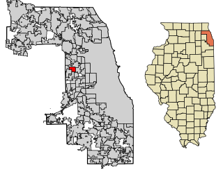
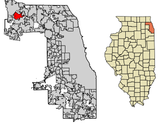
Bellwood is a village in Proviso Township, Cook County, Illinois, United States. Located 13 miles (21 km) west of Chicago's downtown Loop, the Village of Bellwood is bounded by the Eisenhower Expressway (south), the Proviso yards of the former Chicago & Northwestern, now Union Pacific Railroad (north), and the suburbs of Maywood (east) and Hillside and Berkeley (west). The population was 18,789 at the 2020 census.

<span class="mw-page-title-main">Bridgeview, Illinois</span> Village in Illinois, United States

Bridgeview is a village in Cook County, Illinois, United States. It is located approximately 15 miles (24 km) southwest of the Chicago Loop. As of the 2020 census, the village population was 17,027.

<span class="mw-page-title-main">Calumet City, Illinois</span> City in Illinois, United States

Calumet City is a city in Cook County, Illinois, United States. The population was 36,033 at the 2020 census. It is part of the Chicago metropolitan area.

<span class="mw-page-title-main">Calumet Park, Illinois</span> Village in Illinois, United States

Calumet Park is a village in Cook County, Illinois. The population was 7,025 at the 2020 census.

<span class="mw-page-title-main">Forest View, Illinois</span> Village in Illinois, United States

Forest View is a village in Cook County, Illinois, United States. Per the 2020 census, the population was 792. It is primarily an industrial corridor adjacent to the Chicago neighborhood of Garfield Ridge, which is on the village's southern border.

<span class="mw-page-title-main">Lansing, Illinois</span> Village in Illinois, United States

Lansing is a village in Cook County, Illinois, United States. Lansing is a south suburb of Chicago. The population was 29,076 at the 2020 census.

<span class="mw-page-title-main">Lynwood, Illinois</span> Village in Illinois, United States

Lynwood is a village in Cook County, Illinois, United States and a suburb of Chicago. The population was 9,116 at the 2020 census.

<span class="mw-page-title-main">Matteson, Illinois</span> Village in Illinois, United States

Matteson is a village in Cook County, Illinois, United States. The population was 19,073 at the 2020 census. It is a suburb of Chicago.

<span class="mw-page-title-main">Merrionette Park, Illinois</span> Village in Illinois, United States

Merrionette Park is a village in Cook County, Illinois, United States. The population was 1,969 as of the 2020 census.

<span class="mw-page-title-main">Palos Park, Illinois</span> Village in Illinois, United States

Palos Park is a village in southwestern Cook County, Illinois, United States. Per the 2020 census, the population was 4,899.

<span class="mw-page-title-main">Riverdale, Illinois</span> Village in Illinois, United States

Riverdale is a village in Cook County, Illinois, United States. The population was 10,663 at the 2020 census. The village shares its name with the bordering Riverdale neighborhood in Chicago.

<span class="mw-page-title-main">South Barrington, Illinois</span> Village in Illinois, United States

South Barrington is a residential suburb in Cook County, Illinois, United States, south of Barrington. Per the 2020 census, the population was 5,077. South Barrington is a wealthy suburb of Chicago. It is the location of the famous megachurch Willow Creek Community Church, Goebbert's Pumpkin Patch and Farm, and a lifestyle center named The Arboretum of South Barrington.

<span class="mw-page-title-main">South Chicago Heights, Illinois</span> Village in Illinois, United States

South Chicago Heights is a village and a south suburb in Cook County, Illinois, United States. The population was 4,026 at the 2020 census.

<span class="mw-page-title-main">Streamwood, Illinois</span> Village in Illinois, United States

Streamwood is a village in Cook County, Illinois, United States. Per the 2020 census, the population was 39,577. It is a northwest suburb of Chicago, and is a part of the Chicago metropolitan area.

<span class="mw-page-title-main">Thornton, Illinois</span> Village in Illinois, United States

Thornton is a village in Cook County, Illinois, United States and a south suburb of Chicago. The population was 2,386 at the 2020 census. Thornton is home to the Thornton Quarry, one of the largest quarries in the world.

<span class="mw-page-title-main">Fox Lake, Illinois</span> Village in Illinois, United States

Fox Lake is a village in Grant and Antioch townships in Lake County, Illinois and Burton Township, McHenry County, Illinois, United States. The population was 10,978 at the 2020 census. It is located approximately 57 miles north of Chicago.

<span class="mw-page-title-main">Lake Villa, Illinois</span> Village in Illinois, United States

Lake Villa is a village in Lake County, Illinois United States. Per the 2020 census, the population was 8,741. Lake Villa lies within Lake Villa Township and about 50 miles north of Chicago and is part of the United States Census Bureau's Chicago combined statistical area (CSA).

<span class="mw-page-title-main">Griffith, Indiana</span> Town in Indiana, United States

Griffith is a town in North and St. John townships in Lake County, Indiana, United States. It is a part of the Chicago metropolitan area. The population was 16,420 in 2020. The town's population is currently declining at a rate of 0.69% annually. Griffith is the town with the 11th largest population and 17th largest town by area in the State of Indiana.

<span class="mw-page-title-main">Hammond, Indiana</span> City in Indiana, United States

Hammond is a city in Lake County, Indiana, United States. Located along Lake Michigan, it is part of the Chicago metropolitan area and the only city in Indiana to border Chicago. As of the 2020 census, it is the eighth-most populous city in Indiana, with 77,879 residents. It was first settled in the mid-19th century and it is one of the oldest cities of northern Lake County.

<span class="mw-page-title-main">Munster, Indiana</span> Town in Indiana, United States

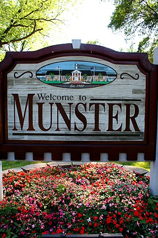
Munster is a suburban town in North Township, Lake County, Indiana, United States. It is in the Chicago metropolitan area, approximately 30 miles (48 km) southeast of the Chicago Loop, and shares municipal boundaries with Hammond to the north, Highland to the east, Dyer and Schererville to the south, and Lansing and Lynwood directly west of the Illinois border. Its population was 23,894 at the 2020 US Census.

References

  1. "2020 U.S. Gazetteer Files". United States Census Bureau. Retrieved March 15, 2022.
  2. "Burnham village, Illinois". United States Census Bureau . Retrieved January 26, 2022.
  3. "US Gazetteer files: 2010, 2000, and 1990". United States Census Bureau. February 12, 2011. Retrieved April 23, 2011.
  4. Bureau, US Census. "Gazetteer Files". Census.gov. Retrieved June 29, 2022.
  5. "Decennial Census of Population and Housing by Decades". United States Census Bureau.
  6. 1 2 "P2: Hispanic or Latino, and Not Hispanic or Latino by Race – 2010: DEC Redistricting Data (PL 94-171) – Burnham, Illinois". United States Census Bureau. Retrieved January 26, 2024.
  7. 1 2 "P2: Hispanic or Latino, and Not Hispanic or Latino by Race – 2020: DEC Redistricting Data (PL 94-171) – Burnham, Illinois". United States Census Bureau. Retrieved January 26, 2024.
  8. "Explore Census Data". data.census.gov. Retrieved June 28, 2022.
  9. "RTA System Map" (PDF). Retrieved January 30, 2024.