East Hazel Crest, Illinois

Last updated

East Hazel Crest
Village of East Hazel Crest
East Hazel Crest Seal.png
Motto: 
The best little village in Illinois
Cook County Illinois Incorporated and Unincorporated areas East Hazel Crest Highlighted.svg
Location of East Hazel Crest in Cook County, Illinois.
Illinois in United States (US48).svg
Location of Illinois in the United States
Coordinates: 41°34′35″N87°39′8″W / 41.57639°N 87.65222°W / 41.57639; -87.65222
CountryFlag of the United States (23px).png  United States
State Illinois
County Cook
Township Thornton
Incorporated 1928
Government
  Type Mayor-council
  Village presidentThomas A. Brown
Area
[1]
  Total0.78 sq mi (2.03 km2)
  Land0.78 sq mi (2.03 km2)
  Water0.00 sq mi (0.00 km2)
Elevation
620 ft (190 m)
Population
 (2020)
  Total1,297
  Density1,654.34/sq mi (638.51/km2)
Time zone UTC-6 (CST)
  Summer (DST) UTC-5 (CDT)
ZIP Code(s)
60429
Area code 708
FIPS code 17-21904
FIPS code 17-21904
GNIS ID 2398777
Wikimedia CommonsEast Hazel Crest, Illinois
Website easthazelcrest.com

East Hazel Crest is a village in Cook County, Illinois, in the United States. It is a south suburb of Chicago. As of the 2020 census, the village population was 1,297.

Contents

History

East Hazel Crest was a part of Hazel Crest when it incorporated in 1911 until the Illinois Central Railroad elevated their commuter and mainline tracks above grade, isolating the rural community from the rest of Hazel Crest. The community voted for incorporation into their own village in 1918. [2] The village later annexed a small commercial area and residential subdivision, Bremerton Woods, that lies west of the Illinois Central Railroad where the village administration and Metra station now stand.

Geography

East Hazel Crest is located at 41°34′35″N87°39′8″W / 41.57639°N 87.65222°W / 41.57639; -87.65222 (41.576384, -87.652171). [3]

According to the 2021 census gazetteer files, East Hazel Crest has a total area of 0.78 square miles (2.02 km2), all land. [4]

Surrounding areas

  Harvey
  Hazel Crest Up arrow left.svg Up-1.svg Up arrow right.svg South Holland
  Hazel Crest Left.svg   Right.svg Thornton
  Homewood Down arrow left.svg Down arrow.svg Down arrow right.svg Homewood
  Homewood

Demographics

Historical population
CensusPop.Note
1920 394
1930 68674.1%
1940 7549.9%
1950 1,06641.4%
1960 1,45736.7%
1970 1,88529.4%
1980 1,362−27.7%
1990 1,57015.3%
2000 1,6072.4%
2010 1,543−4.0%
2020 1,297−15.9%
U.S. Decennial Census [5]
2010 [6] 2020 [7]

As of the 2020 census [8] there were 1,297 people, 575 households, and 356 families residing in the village. The population density was 1,654.34 inhabitants per square mile (638.74/km2). There were 630 housing units at an average density of 803.57 per square mile (310.26/km2). The racial makeup of the village was 57.98% African American, 25.60% White, 0.23% Native American, 0.31% Asian, 0.00% Pacific Islander, 7.09% from other races, and 8.79% from two or more races. Hispanic or Latino of any race were 16.11% of the population.

There were 575 households, out of which 23.3% had children under the age of 18 living with them, 34.78% were married couples living together, 21.57% had a female householder with no husband present, and 38.09% were non-families. 36.00% of all households were made up of individuals, and 14.61% had someone living alone who was 65 years of age or older. The average household size was 3.54 and the average family size was 2.62.

The village's age distribution consisted of 15.9% under the age of 18, 14.2% from 18 to 24, 18% from 25 to 44, 30.6% from 45 to 64, and 21.0% who were 65 years of age or older. The median age was 46.3 years. For every 100 females, there were 79.6 males. For every 100 females age 18 and over, there were 74.1 males.

The median income for a household in the village was $50,583, and the median income for a family was $68,594. Males had a median income of $38,929 versus $31,902 for females. The per capita income for the village was $29,269. About 9.0% of families and 9.0% of the population were below the poverty line, including 4.6% of those under age 18 and 11.4% of those age 65 or over.

East Hazel Crest village, Illinois – Racial and ethnic composition
Note: the US Census treats Hispanic/Latino as an ethnic category. This table excludes Latinos from the racial categories and assigns them to a separate category. Hispanics/Latinos may be of any race.
Race / Ethnicity (NH = Non-Hispanic)Pop 2010 [6] Pop 2020 [7] % 2010% 2020
White alone (NH)48529131.43%22.44%
Black or African American alone (NH)82274853.27%57.67%
Native American or Alaska Native alone (NH)700.45%0.00%
Asian alone (NH)840.52%0.31%
Pacific Islander alone (NH)100.06%0.00%
Some Other Race alone (NH)060.00%0.46%
Mixed Race or Multi-Racial (NH)13390.84%3.01%
Hispanic or Latino (any race)20720913.42%16.11%
Total1,5431,297100.00%100.00%

Government

East Hazel Crest is in Illinois's 2nd congressional district.

Transportation

The Calumet station provides Metra commuter rail service along the Metra Electric District. Trains travel north to Millennium station in Chicago, and south to University Park station. Pace provides bus service on Route 356 connecting East Hazel Crest to destinations across the Southland. [9]

Related Research Articles

<span class="mw-page-title-main">Bellwood, Illinois</span> Village in Illinois, United States

Bellwood is a village in Proviso Township, Cook County, Illinois, United States. Located 13 miles (21 km) west of Chicago's downtown Loop, the Village of Bellwood is bounded by the Eisenhower Expressway (south), the Proviso yards of the former Chicago & Northwestern, now Union Pacific Railroad (north), and the suburbs of Maywood (east) and Hillside and Berkeley (west). The population was 18,789 at the 2020 census.

<span class="mw-page-title-main">Berkeley, Illinois</span> Village in Illinois, United States

Berkeley is a village located in Cook County, Illinois, United States. Incorporated in 1924, the population at the 2020 census was 5,338.

<span class="mw-page-title-main">Calumet Park, Illinois</span> Village in Illinois, United States

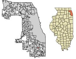
Calumet Park is a village in Cook County, Illinois. The population was 7,025 at the 2020 census.

<span class="mw-page-title-main">Dixmoor, Illinois</span> Village in Illinois, United States

Dixmoor is a village in Cook County, Illinois, United States and a south suburb of Chicago. The population was 2,973 at the 2020 census.

<span class="mw-page-title-main">Flossmoor, Illinois</span> Village in Illinois, United States

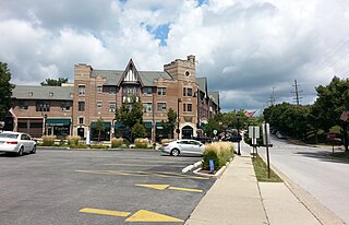
Flossmoor is a village in Cook County, Illinois, United States. The population was 9,704 at the 2020 census. Flossmoor is approximately 24 miles south of The Loop/Downtown Chicago. It is closely tied to neighboring Homewood, sharing a high school and park district.

<span class="mw-page-title-main">Forest View, Illinois</span> Village in Illinois, United States

Forest View is a village in Cook County, Illinois, United States. Per the 2020 census, the population was 792. It is primarily an industrial corridor adjacent to the Chicago neighborhood of Garfield Ridge, which is on the village's southern border.

<span class="mw-page-title-main">Glenwood, Illinois</span> Village in Illinois, United States

Glenwood is a village in Cook County, Illinois, United States. The population was 8,662 at the 2020 census.

<span class="mw-page-title-main">Hanover Park, Illinois</span> Village in Illinois, United States

Hanover Park is a village in Cook and DuPage counties in the U.S. state of Illinois, a suburb of Chicago. The population was 37,470 at the 2020 census. Ontarioville is a neighborhood within the village.

<span class="mw-page-title-main">Harvey, Illinois</span> City in Illinois, United States

Harvey is a city in Cook County, Illinois, United States. The population was 20,324 at the 2020 census.

<span class="mw-page-title-main">Hazel Crest, Illinois</span> Village in Illinois, United States

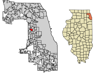
Hazel Crest is a village in Cook County, Illinois, United States. The population was 13,382 at the 2020 census.

<span class="mw-page-title-main">Homewood, Illinois</span> Village in Illinois, United States

Homewood is a village in Cook County, Illinois, United States. The population was 19,463 at the 2020 census.

<span class="mw-page-title-main">Lynwood, Illinois</span> Village in Illinois, United States

Lynwood is a village in Cook County, Illinois, United States and a suburb of Chicago. The population was 9,116 at the 2020 census.

<span class="mw-page-title-main">Olympia Fields, Illinois</span> Village in Illinois, United States

Olympia Fields is a village in Cook County, Illinois, United States. The population was 4,718 as of the 2020 census. It is a southern suburb of Chicago. The municipality grew up around the prestigious Olympia Fields Country Club, originally established in 1915.

<span class="mw-page-title-main">Palos Park, Illinois</span> Village in Illinois, United States

Palos Park is a village in southwestern Cook County, Illinois, United States. Per the 2020 census, the population was 4,899.

<span class="mw-page-title-main">Richton Park, Illinois</span> Village in Illinois, United States

Richton Park is a village and a south suburb of Chicago in Cook County, Illinois, United States. The population was 12,775 at the 2020 census.

<span class="mw-page-title-main">Schiller Park, Illinois</span> Village in Illinois, United States

Schiller Park is a village in Cook County, Illinois, United States. The population was 11,709 at the 2020 census.

<span class="mw-page-title-main">Thornton, Illinois</span> Village in Illinois, United States

Thornton is a village in Cook County, Illinois, United States and a south suburb of Chicago. The population was 2,386 at the 2020 census. Thornton is home to the Thornton Quarry, one of the largest quarries in the world.

<span class="mw-page-title-main">University Park, Illinois</span> Village in Illinois, United States

University Park is a village in Will County with a small portion in Cook County in the U.S. state of Illinois. It is a south suburb of Chicago. The village is one of the region's few planned communities; it was developed in the 1960s as Wood Hill, then Park Forest South, and finally University Park. Governors State University was established in the village in 1969. The village population was 7,145 at the 2020 census.

<span class="mw-page-title-main">Worth, Illinois</span> Village in Illinois, United States

Worth is a village in Cook County, Illinois, United States, a suburb of Chicago. Per the 2020 census, the population was 10,970.

<span class="mw-page-title-main">Thornton Township, Cook County, Illinois</span> Township in Illinois, United States

Thornton Township is one of 29 townships in Cook County, Illinois. As of the 2020 census, its population was 157,865.

References

  1. "2020 U.S. Gazetteer Files". United States Census Bureau. Retrieved March 15, 2022.
  2. "East Hazel Crest, Illinois". Encyclopedia of Chicago. Retrieved November 4, 2019.
  3. "US Gazetteer files: 2010, 2000, and 1990". United States Census Bureau. February 12, 2011. Retrieved April 23, 2011.
  4. Bureau, US Census. "Gazetteer Files". Census.gov. Retrieved June 29, 2022.
  5. "Decennial Census of Population and Housing by Decades". US Census Bureau.
  6. 1 2 "P2 Hispanic or Latino, and Not Hispanic or Latino by Race – 2010: DEC Redistricting Data (PL 94-171) - East Hazel Crest village, Illinois". United States Census Bureau .
  7. 1 2 "P2 Hispanic or Latino, and Not Hispanic or Latino by Race – 2020: DEC Redistricting Data (PL 94-171) - East Hazel Crest village, Illinois". United States Census Bureau .
  8. "Explore Census Data". data.census.gov. Retrieved June 28, 2022.
  9. "RTA System Map" (PDF). Retrieved January 31, 2024.