
St. Joseph County is a county located in the U.S. state of Michigan, on the central southern border with Indiana. As of the 2020 United States Census, the population was 60,939. The county seat is Centreville.

Berrien County is a county in the U.S. state of Michigan. It is located at the southwest corner of the state's Lower Peninsula, located on the shore of Lake Michigan and sharing a land border with Indiana. As of the 2020 Census, the population was 154,316. The county seat is St. Joseph.

Tippecanoe County is located in the west-central portion of the U.S. state of Indiana about 22 miles east of the Illinois state line and less than 50 miles from the Chicago and the Indianapolis metro areas. As of the 2020 census, the population was 186,251. The county seat and largest city is Lafayette. It was created in 1826 from Wabash County portion of New Purchase and unorganized territory.

St. Joseph County, commonly called St. Joe County by residents, is a county located in the U.S. state of Indiana. As of the 2020 census, the population was 272,912, making it the fifth-most populous county in Indiana. Formed in 1830, it was named for the St. Joseph River which flows through it to Lake Michigan. The county seat is South Bend. St. Joseph County is part of the South Bend–Mishawaka, IN–MI "Michiana", Metropolitan Statistical Area.

LaPorte County is a county located in the U.S. state of Indiana. As of 2020, the population was 112,417. The county seat is the city of La Porte, and the largest city is Michigan City. This county is part of the Northwest Indiana and Michiana regions of the Chicago metropolitan area. The LaPorte County Courthouse is located in the county seat of La Porte and is listed on the National Register of Historic Places.
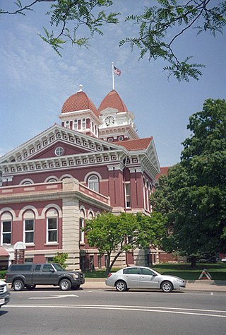
Lake County is a county located in the U.S. state of Indiana. In 2020, its population was 498,700, making it Indiana's second-most populous county. The county seat is Crown Point. The county is part of Northwest Indiana and the Chicago metropolitan area, and contains a mix of urban, suburban and rural areas. It is bordered on the north by Lake Michigan and contains a portion of the Indiana Dunes. It includes Marktown, Clayton Mark's planned worker community in East Chicago.

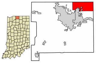
Elkhart County is a county located in the U.S. state of Indiana. As of 2020, the county's population was 207,047. The county seat is Goshen. Elkhart County is part of the Elkhart-Goshen Metropolitan Statistical Area, which in turn is part of the South Bend-Elkhart-Mishawaka Combined Statistical Area. It is also considered part of the broader region of Northern Indiana known as Michiana, and is 20 miles (32 km) east of South Bend, Indiana, 110 miles (180 km) east of Chicago, Illinois, and 150 miles (240 km) north of Indianapolis, Indiana. The area is referred to by locals as the recreation vehicle (RV) capital of the world and is known for its sizable Amish and Old Order Mennonite population.
Granger is a census-designated place (CDP) in Clay and Harris townships, St. Joseph County, in the U.S. state of Indiana. The population was 30,465 at the 2010 census. Penn-Harris-Madison School Corporation and the South Bend Community School Corporation maintain the public schools in the area. Granger is part of the South Bend–Mishawaka metropolitan area as well as the larger Michiana region.

Notre Dame is a census-designated place and unincorporated community north of the city of South Bend in St. Joseph County, in the U.S. state of Indiana. It includes the campuses of three colleges: the University of Notre Dame, Saint Mary's College, and Holy Cross College. Notre Dame is split between Clay and Portage Townships. As of the 2020 census, its population was 7,234.

Wyatt is an unincorporated community located in Madison Township, St. Joseph County, in the U.S. state of Indiana.
Howe is an unincorporated community and census-designated place in Lima Township, LaGrange County, Indiana. As of the 2010 census its population was 807.

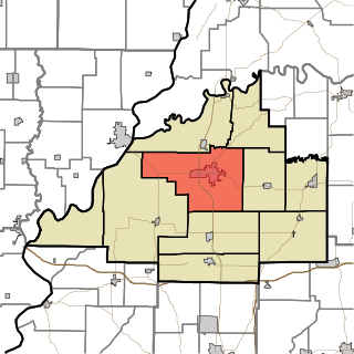
Colburn is a small unincorporated census-designated place in northeastern Washington Township, Tippecanoe County, in the U.S. state of Indiana.
Patoka Township is one of ten townships in Gibson County, Indiana, United States. As of the 2010 census, its population was 11,864 and it contained 5,341 housing units. It is the largest township in population, accounting for roughly 30% of the county's total population.

Union Township is one of thirteen townships in St. Joseph County, in the U.S. state of Indiana. As of the 2000 census, its population was 3,289.

Saint Joseph Township is one of twenty townships in Allen County, Indiana, United States. As of the 2010 census, its population was 72,245.
Westfield is an unincorporated community in Warren Township, St. Joseph County, in the U.S. state of Indiana.
Crumstown is an unincorporated community in LaPorte and St. Joseph counties, in the U.S. state of Indiana.
Plainfield is an unincorporated community in St. Joseph County, Indiana, United States. It is along U.S. Route 20 in the north-central part of Olive Township and is bordered to the south and west by the town of New Carlisle. Via US-20, Plainfield is 13 miles (21 km) west of South Bend and 23 miles (37 km) east of Michigan City.
The South Bend–Mishawaka Metropolitan Statistical Area, sometimes referred to as Michiana, as defined by the United States Census Bureau, is an area consisting of two counties – one in northern Indiana and one in southwest Michigan (Cass), anchored by the cities of South Bend and Mishawaka in Indiana. As of the 2010 census, the MSA had a population of 319,224.


