
Bertrand Township is a civil township of Berrien County in the U.S. state of Michigan. As of the 2010 census, the township population was 2,657.

Michiana is a region in northern Indiana and southwestern Michigan centered on the city of South Bend, Indiana. The Chamber of Commerce of St. Joseph County, Indiana defines Michiana as St. Joseph County and "counties that contribute at least 500 inbound commuting workers to St. Joseph County daily." Those counties include Elkhart, La Porte, Marshall, St. Joseph, and Starke in Indiana, and Berrien and Cass in Michigan. As of the 2010 census, those seven counties had a population of 856,377.
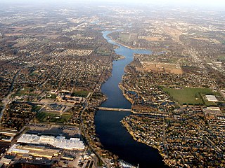
The St. Joseph River is a tributary of Lake Michigan with a length of 206 miles (332 km). The river flows in a generally westerly direction through southern Michigan and northern Indiana, United States, to its terminus on the southeast shore of the lake. It drains a primarily rural farming area in the watershed of Lake Michigan. It was enormously important to Native Americans and greatly aided in the colonial exploration, settlement and administration of New France and the nascent United States as a canoe route between Lake Michigan and the watershed of the Mississippi River.

The Monon Railroad, also known as the Chicago, Indianapolis, and Louisville Railway from 1897 to 1971, was an American railroad that operated almost entirely within the state of Indiana. The Monon was merged into the Louisville and Nashville Railroad in 1971, and much of the former Monon right of way is owned today by CSX Transportation. In 1970, it operated 540 miles (870 km) of road on 792 miles (1,275 km) of track; that year it reported 1320 million ton-miles of revenue freight and zero passenger-miles.
The Lake Shore and Michigan Southern Railway, established in 1833, and sometimes referred to as the Lake Shore, was a major part of the New York Central Railroad's Water Level Route from Buffalo, New York, to Chicago, Illinois, primarily along the south shore of Lake Erie and across northern Indiana. The line's trackage remains a major rail transportation corridor used by Amtrak passenger trains and several freight lines; in 1998, its ownership was split at Cleveland, Ohio, between CSX Transportation to the east and Norfolk Southern Railway in the west.

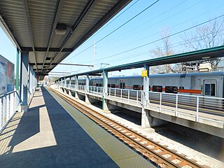
The South Shore Line is an electrically powered interurban commuter rail line operated by the Northern Indiana Commuter Transportation District (NICTD) between Millennium Station in downtown Chicago and the South Bend International Airport in South Bend, Indiana, United States. The name refers to both the physical line and the service operated over that route. The line was built in 1901–1908 by predecessors of the Chicago South Shore and South Bend Railroad, which continues to operate freight service. Passenger operation was assumed by the NICTD in 1989. The South Shore Line is one of the last surviving interurban trains in the United States. In 2022, the system had a ridership of 1,406,400, or about 5,300 per weekday as of the third quarter of 2023.

The Michigan Central Railroad was originally chartered in 1832 to establish rail service between Detroit, Michigan, and St. Joseph, Michigan. The railroad later operated in the states of Michigan, Indiana, and Illinois in the United States and the province of Ontario in Canada. After about 1867 the railroad was controlled by the New York Central Railroad, which later became part of Penn Central and then Conrail. After the 1998 Conrail breakup, Norfolk Southern Railway now owns much of the former Michigan Central trackage.

Central Station was an intercity passenger terminal in downtown Chicago, Illinois, at the southern end of Grant Park near Roosevelt Road and Michigan Avenue. Owned by the Illinois Central Railroad, it also served other companies via trackage rights. It opened in 1893, replacing Great Central Station, and closed in 1972 when Amtrak rerouted services to Union Station. The station building was demolished in 1974. It is now the site of a redevelopment called Central Station, Chicago.
The Michigan Air Line Railroad was a railroad across southern Michigan, connecting the Canada Southern Railway to Chicago, Illinois. Only part of the line was built before the company that first built it folded, and it was split between the Michigan Central Railroad and the Grand Trunk Railway, which completed the line.
Northwest Indiana, nicknamed The Region after the Calumet Region, comprises Lake, Porter, LaPorte, and Newton counties in Indiana. This region neighbors Lake Michigan and is part of the Chicago metropolitan area. According to the 2020 Census, Northwest Indiana has a population of 831,080 and is the state's second largest urban area after the Indianapolis Metropolitan Area. It is also the home of the Indiana Dunes, parts of which have been preserved through conservation efforts. The town of Ogden Dunes houses the Hour Glass, a museum showcasing the ecological and conservation efforts of O. D. Frank.
Hammond is a South Shore Line station in Hammond, Indiana that serves trains west and north to Millennium Station and east to East Chicago, Gary, Michigan City, and South Bend, Indiana. Westbound, this is the last stop before trains cross into Illinois, and the first stop in Indiana for outbound trains.
Warren Township is one of thirteen townships in St. Joseph County, in the U.S. state of Indiana. As of the 2000 census, its population was 6,430.

Hudson Lake is an unincorporated community and census-designated place (CDP) in Hudson Township, LaPorte County, Indiana, United States. The town sits on the dividing line between Central and Eastern time zones. It is the site of the Hudson Lake station stop of the South Shore Line. As of the 2010 census, the population of the CDP was 1,297.

The Kankakee Outwash Plain is a flat plain interspersed with sand dunes in the Kankakee River valley in northwestern Indiana and northeastern Illinois of the United States. It is just south of the Valparaiso Moraine and was formed during the Wisconsin Glaciation. As the glacier stopped at the Valparaiso Moraine, its meltwater was carried away to the outwash plain. On the south side of the moraine, where the elevation drops, the meltwaters eroded away valleys, carrying sand and mud with them. As the muddy meltwater reached the valley where the slope lessened, the water slowed, depositing the sand on the outwash plain. This created a smooth, flat, and sandy plain. Before its draining, the Kankakee Marsh, located on the outwash plain, was one of the largest freshwater marshes in the United States.
The South Bend–Mishawaka Metropolitan Statistical Area, sometimes referred to as Michiana, as defined by the United States Census Bureau, is an area consisting of two counties – one in northern Indiana and one in southwest Michigan (Cass), anchored by the cities of South Bend and Mishawaka in Indiana. As of the 2010 census, the MSA had a population of 319,224.

The Vandalia Railroad Company was incorporated January 1, 1905, by a merger of several lines in Indiana and Illinois that formed a 471-mile railroad consisting of lines mostly west of Indianapolis.

Lake Kankakee formed 14,000 years before present (YBP) in the valley of the Kankakee River. It developed from the outwash of the Michigan Lobe, Saginaw Lobe, and the Huron-Erie Lobe of the Wisconsin glaciation. These three ice sheets formed a basin across Northwestern Indiana. It was a time when the glaciers were receding, but had stopped for a thousand years in these locations. The lake drained about 13,000 YBP, until reaching the level of the Momence Ledge. The outcropping of limestone created an artificial base level, holding water throughout the upper basin, creating the Grand Kankakee Marsh.
New Carlisle was a South Shore Line flag stop located at the corner of Arch and Zigler Streets in New Carlisle, Indiana. The station opened circa 1908 and was built by the Chicago, South Bend and Northern Indiana Railway whose line was immediately north of the South Shore Line. Both lines used the station until the Northern Indiana Railway abandoned its South Bend–Michigan City line leaving the South Shore as the sole occupant. The station remained in service on the South Shore Line until July 5, 1994, when it was closed as part of an NICTD service revision which also saw the closure of Ambridge, Kemil Road, Willard Avenue, LaLumiere, and Rolling Prairie.

The town of New Carlisle, abutting the LaPorte County line in Olive Township in northwestern St. Joseph County, perches on a hill overlooking the rich Terre Coupee prairie to the east. Its main street, Michigan Street, at forty-five feet is wider than the town's other streets and has been from its platting in 1835 a part of an improved thoroughfare, first the Michigan Road, later the Lincoln Highway and, finally, US 20. Two parallel railroads, Conrail and the electrically powered South Shore, run along the town's north edge at the bottom of the hill, beyond which still lies open farmland. This is largely true to the west and south as well, although in recent years commercial development has occurred at the western edge of town along US 20 at the county line, and some residential development to the south. Along US 20 to the east is a long line of ca. 1950 housing development, which until recently edged farmland between the highway and the railroads. Now much of this farmland is zoned industrial, owing largely to the construction less than 2 miles (3.2 km) away of the enormous I/N Tek steel mill, completed in 1990, and its subsidiary I/N Kote, in 1991. The district is the main commercial district on Michigan Street.


