
St. Joseph County, commonly called St. Joe County by residents, is a county located in the U.S. state of Indiana. As of the 2020 census, the population was 272,912, making it the fifth-most populous county in Indiana. Formed in 1830, it was named for the St. Joseph River which flows through it to Lake Michigan. The county seat is South Bend. St. Joseph County is part of the South Bend–Mishawaka, IN–MI "Michiana", Metropolitan Statistical Area.

Elkhart County is a county located in the U.S. state of Indiana. As of 2020, the county's population was 207,047. The county seat is Goshen. Elkhart County is part of the Elkhart-Goshen Metropolitan Statistical Area, which in turn is part of the South Bend-Elkhart-Mishawaka Combined Statistical Area. It is also considered part of the broader region of Northern Indiana known as Michiana, and is 20 miles (32 km) east of South Bend, Indiana, 110 miles (180 km) east of Chicago, Illinois, and 150 miles (240 km) north of Indianapolis, Indiana. The area is referred to by locals as the recreation vehicle (RV) capital of the world and is known for its sizable Amish and Old Order Mennonite population.
Iroquois County is a county located in the northeast part of the U.S. state of Illinois. According to the 2020 United States Census, it has a population of 27,077. It is the only county in the United States to be named Iroquois, after the American Indian people. The county seat is Watseka. The county is located along the border with Indiana.
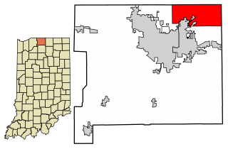
Granger is a census-designated place (CDP) in Clay and Harris townships, St. Joseph County, in the U.S. state of Indiana. The population was 30,465 at the 2010 census. Penn-Harris-Madison School Corporation and the South Bend Community School Corporation maintain the public schools in the area. Granger is part of the South Bend–Mishawaka metropolitan area as well as the larger Michiana region.

South Bend is a city in and the county seat of St. Joseph County, Indiana, United States, on the St. Joseph River near its southernmost bend, from which it derives its name. At the 2020 census, the city had a total of 103,453 residents and is the fourth-largest city in Indiana. The metropolitan area had a population of 324,501 in 2020, while its combined statistical area had 812,199. The city is located just south of Indiana's border with Michigan.
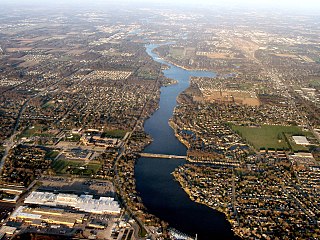
The St. Joseph River is a tributary of Lake Michigan with a length of 206 miles (332 km). The river flows in a generally westerly direction through southern Michigan and northern Indiana, United States, to its terminus on the southeast shore of the lake. It drains a primarily rural farming area in the watershed of Lake Michigan. It was enormously important to Native Americans and greatly aided in the colonial exploration, settlement and administration of New France and the nascent United States as a canoe route between Lake Michigan and the watershed of the Mississippi River.

Notre Dame is a census-designated place and unincorporated community north of the city of South Bend in St. Joseph County, in the U.S. state of Indiana. It includes the campuses of three colleges: the University of Notre Dame, Saint Mary's College, and Holy Cross College. Notre Dame is split between Clay and Portage Townships. As of the 2020 census, its population was 7,234.
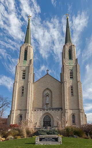
The Diocese of Fort Wayne–South Bend is a Latin Church ecclesiastical territory, or diocese, of the Catholic Church in north-central and northeastern Indiana in the United States.

Wyatt is an unincorporated community located in Madison Township, St. Joseph County, in the U.S. state of Indiana.

Harris Township is one of thirteen townships in St. Joseph County, in the U.S. state of Indiana. As of the 2000 census, its population was 19,873.
Crumstown is an unincorporated community in LaPorte and St. Joseph counties, in the U.S. state of Indiana.
Saint Joseph, affectionately called St. Joe County by locals, is an unincorporated community in German Township, Vanderburgh County, Indiana, United States and centered on St. Joseph Catholic Church. Along with that of Darmstadt, its colonization marked the beginning of German-American immigration to southern Indiana. The area was chosen as a settlement for its rich farmland.
Lydick is an unincorporated community in Warren Township, St. Joseph County, in the U.S. state of Indiana.
Olive is an unincorporated community in Olive Township, St. Joseph County, in the U.S. state of Indiana.
Hamilton is an unincorporated community in Olive Township, St. Joseph County, in the U.S. state of Indiana.
The 138th Indiana Infantry Regiment served in the Union Army between May 27 and September 22, 1864, during the American Civil War.
Nutwood is an unincorporated community in Centre Township, St. Joseph County, in the U.S. state of Indiana.
Tamarack Grange is an unincorporated community in Penn Township, St. Joseph County, in the U.S. state of Indiana.


