
Jedburgh is a town and former royal burgh in the Scottish Borders and the traditional county town of the historic county of Roxburghshire, the name of which was randomly chosen for Operation Jedburgh in support of the D-Day invasion.

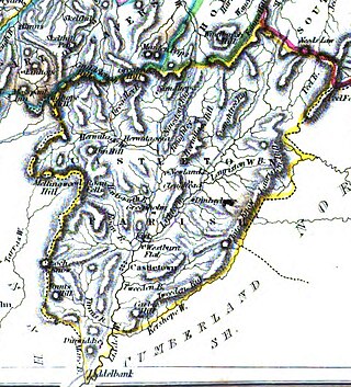
Roxburghshire or the County of Roxburgh is a historic county and registration county in the Southern Uplands of Scotland. It borders Dumfriesshire to the west, Selkirkshire and Midlothian to the northwest, and Berwickshire to the north. To the southwest it borders Cumberland and to the southeast Northumberland, both in England.

Cessford Castle is a large ruined mid-15th century L-plan castle near the village of Cessford, midway Jedburgh and Kelso, in the historic county of Roxburghshire, now a division of the Scottish Borders. The Castle is caput of the Barony of Cessford, and the principal stronghold of the Kers/Kerrs, notorious Border Reivers, many of whom served as Wardens of the Middle March.

Abbotrule is a hamlet south of the B6357 road, in the Scottish Borders area of Scotland, on Rule Burn, east of the Rule Water. Places nearby include Bedrule, Hallrule, Spittal-on-Rule, Ruletownhead, Bonchester Bridge, Denholm, Southdean, Hobkirk, Ferniehirst Castle and the Wauchope Forest.

Nisbet is a small hamlet on the B6400, in Roxburghshire, along the River Teviot, in the Scottish Borders area of Scotland. It is located 5.5 kilometres (3.4 mi) north of Jedburgh and 5 kilometres (3.1 mi) south of Roxburgh.

Bemersyde House is a historic house in Roxburghshire, Scotland.
Oxnam is a village near Jedburgh, in Roxburghshire in the Scottish Borders area of Scotland. It is a primarily residential village.
Holydean Castle was a castle sited near Melrose in Bowden, 1.25 miles SW of the village, in the Scottish Borders region of Scotland, and the former Roxburghshire.

Jedburgh Castle was a castle at Jedburgh in Scotland. It was fought over during the Wars of Scottish Independence, and was demolished by the Scots commanded by Sir James Douglas of Balvenie in 1409. The site of the original castle was used to build the reform prison based on John Howard system, the construction of which started in 1820.
Maxton is a hamlet and civil parish in Roxburghshire, Scotland, and part of the Scottish Borders region.

Camptown is a small settlement on the A68, in the Scottish Borders area of Scotland, 5m (8 km) south of Jedburgh, and the same distance south to Carter Bar. The village lies on the course of the Jed Water, and the remains of a peel tower are close by at Edgerston.

Bedrule is a hamlet and civil parish in the historic county of Roxburghshire in the Scottish Borders area of Scotland. The hamlet lies on the east side of the Rule Water, which gave the village its name, about 4 miles west of Jedburgh. It lies south of the A698 between Hawick and Jedburgh. Other local place-names based on the river include Hallrule, Abbotrule, Ruletownhead and Spittal-on-Rule. Larger settlements include Bonchester Bridge and Denholm, as well as Hawick and Jedburgh.

Peniel Heugh is a hill near Ancrum and Nisbet in the Scottish Borders area of Scotland. On it stands the Waterloo Monument.

Liddel Castle is a ruined castle in Liddesdale, by the Liddel Water, near Castleton in the Scottish Borders area of Scotland, in the former county of Roxburghshire. Liddel Castle is a scheduled monument.
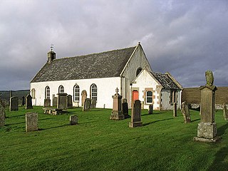
Castleton is a civil parish in the Scottish Borders area of Scotland, in the former Roxburghshire, in the extreme south of the Borders area. It is bounded by Northumberland (England), Dumfries and Galloway, and the parishes of Hobkirk, Southdean and Teviothead. The village of Castleton was commenced in 1793. It was built as a result of the land clearances in the 1790s when people were forced to move from Old Castleton village. While the parish retained the name Castleton, the village later became identified as New Castleton or Newcastleton. The parish is also known by its older name Liddesdale
Dinlabyre is a village on the B6357 in Liddesdale, on the edge of the Newcastleton Forest, close to Castleton, in the Scottish Borders area of Scotland, in the former Roxburghshire.

Crailinghall is a village near Oxnam in the Scottish Borders area of Scotland, in the former Roxburghshire.

Ettleton is a village near Castleton, in the Scottish Borders area of Scotland, in the former Roxburghshire.

Yetholm Loch is a loch near Kelso, in the Scottish Borders area of Scotland, in the former Roxburghshire.
Sir David Olifard was the first recorded Justiciar, governing the southern half of Scotland south of the rivers Forth and Clyde. Olifard was godson to King David I of Scotland, whose life he saved at the Rout of Winchester in 1141. Olifard is the first known chief of Clan Oliphant today.
