Kelso, Scottish Borders

Last updated

Kelso
Riverside walk, Kelso - geograph.org.uk - 4156379.jpg
Kelso seen from the banks of the Tweed
Scottish Borders UK location map.svg
Red pog.svg
Kelso
Location within the Scottish Borders
Population6,870 (mid-2020 est.) [1]
OS grid reference NT7268233961
  Edinburgh 44 mi (71 km)
  London 350 mi (560 km)
Council area
Lieutenancy area
Country Scotland
Sovereign state United Kingdom
Post town KELSO
Postcode district TD5
Dialling code 01573
Police Scotland
Fire Scottish
Ambulance Scottish
UK Parliament
Scottish Parliament
List of places
UK
Scotland
55°35′55″N2°26′01″W / 55.59851°N 2.43357°W / 55.59851; -2.43357

Kelso is a market town in the Scottish Borders area of Scotland. Within the boundaries of the historic county of Roxburghshire, it lies where the rivers Tweed and Teviot have their confluence. The town has a population of 5,639 according to the 2011 census and based on the 2010 definition of the locality. [2]

Contents

Kelso's main tourist attractions are the ruined Kelso Abbey and Floors Castle. The latter is a house designed by William Adam which was completed in 1726. The Kelso Bridge was designed by John Rennie, who later built London Bridge.

Kelso held the UK record for the lowest January temperature at −26.7 °C (−16.1 °F), from 1881 until 1982. [3]

History

The town of Kelso came into being as a direct result of the creation of Kelso Abbey in 1128. The town's name stems from the earliest settlement having stood on a chalky outcrop, and the town was known as Calkou (or perhaps Calchfynydd) in those early days, something that is remembered in the modern street name, "Chalkheugh Terrace". [4]

Kelso Town Hall Scottish Borders Kelso Town Hall.jpg
Kelso Town Hall

Standing on the opposite bank of the River Tweed from the now-vanished royal burgh of Roxburgh, Kelso and its sister hamlet of Wester Kelso were linked to the burgh by a ferry at Wester Kelso. A small hamlet existed before the completion of the abbey in 1128 but the settlement started to flourish with the arrival of the monks. Many were skilled craftsmen, and they helped the local population as the village expanded.

Archaeological excavations in the 1980s discovered that the original medieval burgh of Wester Kelso was much farther west than previously believed and that it was abandoned in the 14th or 15th centuries, at the same time that the royal burgh of Roxburgh was deserted, likely the result of the English occupation of Roxburgh Castle. The other settlement of Easter Kelso, near the abbey, survived and expanded from the market area around the abbey northwards towards the Floors estate by the early 18th century. Thus 'Easter' Kelso, became Kelso. [5]

The abbey controlled much of life in Kelso-area burgh of barony, called Holydean, until the Reformation in the 16th century. After that, the power and wealth of the abbey declined. The Kerr family of Cessford took over the barony and many of the abbey's properties around the town. By the 17th century, they virtually owned Kelso.

In Roxburgh Street is the outline of a horseshoe petrosomatoglyph where the horse of Charles Edward Stuart cast a shoe as he was riding it through the town on his way to Carlisle in 1745. He is also said to have planted a white rosebush in his host's garden, descendants of which are still said to flourish in the area. [6]

For some period of time, the Kelso parish was able to levy a tax of 2 pence (2d) on every Scottish pint of ale, beer or porter sold within the town. [7] [8] The power to do this was extended for 21 years in 1802 under the Kelso Two Pennies Scots Act when the money was being used to replace a bridge across the River Tweed that had been destroyed by floods. [7]

Kelso Town Hall was completed in 1816 and remodelled in 1908. [9] The Corn Exchange, which now accommodates a health clinic, a dental clinic and an online publisher, was completed in 1856, [10] and the war memorial was erected in 1921 to a design by Sir Robert Lorimer. [11]

Community

View of Kelso in the late 18th century Kelso Abbey and the auld brig in the late 18th century.JPG
View of Kelso in the late 18th century
Teviot Bridge Near Kelso Teviot Bridge near Kelso - geograph.org.uk - 368629.jpg
Teviot Bridge Near Kelso

Kelso High School provides secondary education to the town, and primary education is provided by Edenside Primary and Broomlands Primary.

The River Tweed at Kelso is renowned for its salmon fishing. There are two eighteen-hole golf courses as well as a National Hunt (jumping) horse racing track. Kelso Racecourse is known as "Britain's Friendliest Racecourse." Racing first took place in Kelso in 1822.

In 2005, the town hosted the 'World Meeting of Citroën 2CV Friends' in the grounds of nearby Floors Castle.

Kelso Community Council is made up of 12 Community Councillors, who remain in office for 4 years per term. The post of Chairman and Town Provost is currently held by Gavin Horsburgh until October 2025.

The town's rugby union club is Kelso RFC. The club holds an annual rugby sevens tournament takes place in early May. Former players include Ross Ford, the current record holder for men's senior caps with the Scotland men's rugby union team. Other former players include John Jeffrey, Roger Baird, Andrew Ker and Adam Roxburgh, who all featured in 7s teams that dominated the Borders circuit in the 1980s - including several wins in the blue ribbon event at Melrose. Kelso RFC also hold an annual rugby fixture; this fixture is the oldest unbroken fixture between a Scottish and Welsh side.

Every year in July, the town celebrates the border tradition of Common Riding, known as Kelso Civic Week. The festival lasts a full week and is headed by the Kelsae Laddie with his Right and Left Hand Men. The Laddie and his followers visit neighbouring villages on horseback with the climax being the Yetholm Ride on the Saturday. Kelso hosts its annual fair on the first weekend of September. The festivities include dancing, street entertainers, live music, stalls and a free concert. The fair attracts about 10,000 people to the town.

People

Horsemen riding the marches of Kelso Riding through the streets of Kelso - geograph.org.uk - 4075192.jpg
Horsemen riding the marches of Kelso

Sir Walter Scott attended Kelso Grammar School in 1783 and he said of the town: "it is the most beautiful if not the most romantic village in Scotland". Another attraction is the Cobby Riverside Walk which goes from the town centre to Floors Castle along the banks of the Tweed passing the point where it is joined by the River Teviot. Kelso has two bridges that span the River Tweed, "Rennie's Bridge" was completed in 1803 [12] to replace an earlier one washed away in the floods of 1797, it was built by John Rennie of Haddington, who later went on to build Waterloo Bridge in London, his bridge in Kelso is a smaller and earlier version of Waterloo Bridge. The bridge was the cause of local rioting in 1854 when the Kelso population objected to paying tolls even when the cost of construction had been covered, the Riot Act was read, three years later tolls were abolished. Hunter's Bridge, a kilometre downstream, is a modern construction built to divert vehicles around the town and so take much of the heavy traffic that has damaged Rennie's bridge.

Famous people from Kelso have included the suffragette Georgiana Solomon who was born here in 1844, the civil engineer Sir James Brunlees (1816–1892) who constructed many railways in the United Kingdom as well as designing the docks at Avonmouth and Whitehaven. Sir William Fairbairn (1789–1874) was another engineer who built the first iron hulled steamship the Lord Dundas and constructed over 1,000 bridges using the tubular steel method which he pioneered. Thomas Pringle the writer, poet and abolitionist, was born at nearby Blakelaw, a 500-acre (2.0 km2) farmstead four miles (6 km) to the south of the town where his father was the tenant. Donald Farmer, a Victoria Cross recipient was born in Kelso, as was Ross Ford, who holds the record for the most senior caps (110) with the men's Scotland national rugby union team.

Robert Allan Smith (1909-1980) physicist, was born and brought up in Kelso.

Notable people

Film, music and literature

Much of the 1984 film Greystoke: The Legend of Tarzan, Lord of the Apes was filmed on location at Floors Castle in Kelso, which featured as the fictional Greystoke Manor. [14]

Kelso features in the traditional folk music ballad 'The Shepherd Lad of Kelso', as well as 'The Old Woman of Kelso', a variation of the ballad Eggs and Marrowbone.

Floors Castle

Walled garden at Floors Castle Herbaceous border in the walled garden at Floors Castle. - geograph.org.uk - 286913.jpg
Walled garden at Floors Castle

Floors Castle is a large stately home built in the 1720s just outside of Kelso. [15] It is a visitor attraction. Adjacent to the house there is a large walled garden with a cafe, a small garden centre and the Star Plantation.

Media

Local news and television programmes are provided by BBC Scotland and ITV Border. Television signal is received from the Selkirk TV transmitter. [16]

Kelso's local radio stations are BBC Radio Scotland on 93.5 FM and Greatest Hits Radio Scottish Borders and North Northumberland on 96.8 FM.

The local newspapers are Southern Reporter and Border Telegraph. [17]

Twin towns

Kelso is twinned with two cities abroad:

Panorama

Kelso is unique in Scotland for having a cobbled square fed by four cobbled streets Stitchedkelsowiki.jpg
Kelso is unique in Scotland for having a cobbled square fed by four cobbled streets

Weather

On 19 July 2022, The Town Set Scotlands Hottest Temperature Record At 35.1°C, Beating The Record Of 32.9°C In Greycrook

See also

Related Research Articles

<span class="mw-page-title-main">Hawick</span> A town in the Borders of Scotland

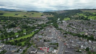
Hawick is a town in the Scottish Borders council area and historic county of Roxburghshire in the east Southern Uplands of Scotland. It is 10 miles (16.1 km) south-west of Jedburgh and 8.9 miles (14.3 km) south-south-east of Selkirk. It is one of the furthest towns from the sea in Scotland, in the heart of Teviotdale, and is the biggest town in Roxburghshire. The town is at the confluence of the Slitrig Water with the River Teviot.

<span class="mw-page-title-main">Scottish Borders</span> Council area of Scotland

The Scottish Borders is one of 32 council areas of Scotland. It is bordered by West Lothian, Edinburgh, Midlothian, and East Lothian to the north, the North Sea to the east, Dumfries and Galloway to the south-west, South Lanarkshire to the west, and the English ceremonial counties of Cumbria and Northumberland to the south. The largest settlement is Galashiels, and the administrative centre is Newtown St Boswells.

<span class="mw-page-title-main">Duke of Roxburghe</span> Title in the peerage of Scotland

The Duke of Roxburghe is a title in the peerage of Scotland created in 1707 along with the titles Marquess of Bowmont and Cessford, Earl of Kelso and Viscount Broxmouth. John Ker, 5th Earl of Roxburghe became the first holder of these titles. The title is derived from the royal burgh of Roxburgh in the Scottish Borders that in 1460 the Scots captured and destroyed.

<span class="mw-page-title-main">Jedburgh</span> Town in Scottish Borders, UK

Jedburgh is a town and former royal burgh in the Scottish Borders and the traditional county town of the historic county of Roxburghshire.

<span class="mw-page-title-main">Peebles</span> Town in Scottish Borders, Scotland, UK

Peebles is a town in the Scottish Borders, Scotland. It was historically a royal burgh and the county town of Peeblesshire. According to the 2011 census, the population was 8,376 and the estimated population in June 2018 was 9,000.

<span class="mw-page-title-main">Selkirk, Scottish Borders</span> Town in Scotland, UK

Selkirk is a town and historic royal burgh in the Scottish Borders council district of southeastern Scotland. It lies on the Ettrick Water, a tributary of the River Tweed.

<span class="mw-page-title-main">Roxburghshire</span> Historic county in Scotland

Roxburghshire or the County of Roxburgh is a historic county and registration county in the Southern Uplands of Scotland. It borders Dumfriesshire to the west, Selkirkshire and Midlothian to the northwest, and Berwickshire to the north. To the southwest it borders Cumberland and to the southeast Northumberland, both in England.

<span class="mw-page-title-main">Roxburgh</span> Civil parish in Roxburghshire, Scotland

Roxburgh is a civil parish and formerly a royal burgh, in the historic county of Roxburghshire in the Scottish Borders, Scotland. It was an important trading burgh in High Medieval to early modern Scotland. In the Middle Ages it had at least as much importance as Edinburgh, Stirling, Perth, or Berwick-upon-Tweed, for a time acting as de facto capital.

<span class="mw-page-title-main">Kelso Abbey</span> Ruined abbey in Kelso, Scotland, UK

Kelso Abbey is a ruined Scottish abbey in Kelso, Scotland. It was founded in the 12th century by a community of Tironensian monks first brought to Scotland in the reign of Alexander I. It occupies ground overlooking the confluence of the Tweed and Teviot waters, the site of what was once the Royal Burgh of Roxburgh and the intended southern centre for the developing Scottish kingdom at that time. Kelso thus became the seat of a pre-eminently powerful abbacy in the heart of the Scottish Borders.

<span class="mw-page-title-main">River Teviot</span> River in Scottish Borders, Scotland, UK

The River Teviot, or Teviot Water, is a river of the Scottish Borders area of Scotland, and is the largest tributary of the River Tweed by catchment area. The Teviot is an important river for wildlife, especially the Atlantic salmon, but in recent years has witnessed at least four extreme flooding events.

<span class="mw-page-title-main">Floors Castle</span> Estate house in Scottish Borders, Scotland

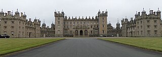
Floors Castle, in Roxburghshire, south-east Scotland, is the seat of the Duke of Roxburghe. Despite its name it is an estate house rather than a fortress. It was built in the 1720s by the architect William Adam for Duke John, possibly incorporating an earlier tower house. In the 19th century it was embellished with turrets and battlements, designed by William Playfair, for The 6th Duke of Roxburghe. Floors has the common 18th-century layout of a main block with two symmetrical service wings. Floors Castle stands by the bank of the River Tweed and overlooks the Cheviot Hills to the south.

<span class="mw-page-title-main">Roxburgh Castle</span> Ruined castle near Roxburgh, Scotland

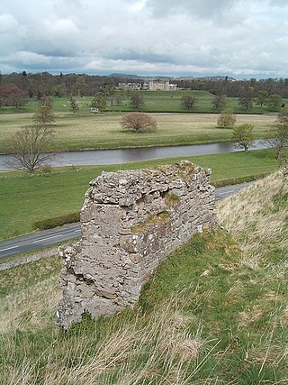
Roxburgh Castle is a ruined royal castle that overlooks the junction of the rivers Tweed and Teviot, in the Borders region of Scotland. The town and castle developed into the royal burgh of Roxburgh, which the Scots destroyed along with the castle after capturing it in 1460. Today the ruins stand in the grounds of Floors Castle, the seat of the Duke of Roxburghe, across the river from Kelso.

<span class="mw-page-title-main">Halydean</span> Scottish feudal Crown Barony and Lordship in Roxburghshire

Halydean is a Scottish feudal Crown Barony and Lordship in Roxburghshire in the neighbourhood of Kelso, in the Borderlands of Scotland, along the River Tweed. This area along the Tweed is home to the Scottish border clans, including the Armstrongs, Douglases, Elliots, Johnstones, Kers, Moffats, and many others. The Barony and Lordship of Halydean (Holydean) is one of the oldest Norman feudal baronies in Scotland with a living claimant.

<span class="mw-page-title-main">Anglo-Scottish border</span> 96-mile long border between England and Scotland

The Anglo-Scottish border is a border separating Scotland and England which runs for 96 miles (154 km) between Marshall Meadows Bay on the east coast and the Solway Firth in the west.

<span class="mw-page-title-main">Roxburgh (village)</span> Village in Scottish Borders, Scotland, UK

Roxburgh is a village off the A699, by the River Teviot, near Kelso in the Scottish Borders area of Scotland.

Kelso High School is a state-funded comprehensive secondary school in Kelso, Scotland, under the control of the Scottish Borders Council. It is one of nine secondary schools in the Scottish Borders and the only one in Kelso. Pupils come to Kelso High School from the town of Kelso, the villages of Ednam, Eckford, Stichill, Smailholm, Morebattle, Roxburgh, Yetholm and other hamlets in the surrounding area. The current building was opened to students in November 2017.

<span class="mw-page-title-main">Kelso Bridge</span> Bridge

The Kelso Bridge or Rennie's Bridge is a bridge across the River Tweed at Kelso, in the Scottish Borders.

<span class="mw-page-title-main">Kelso Town Hall</span> Municipal building in Kelso, Scotland

Kelso Town Hall is a municipal building in The Square, Kelso, Scotland. The building, which was the headquarters of Kelso Burgh Council, is a Category B listed building.

References

  1. "Mid-2020 Population Estimates for Settlements and Localities in Scotland". National Records of Scotland. 31 March 2022. Retrieved 31 March 2022.
  2. "Kelso, Scottish Borders". City Population. Retrieved 3 June 2015.
  3. "Weather January".
  4. Moffat, A., (2006). Kelsae: A History of Kelso from Earliest Times. page 12. Birlinn Ltd. ISBN   1841584576
  5. "Vol 2 (2003): The origins of settlements at Kelso and Peebles, Scottish Borders archaeological excavations in Wester and Easter Kelso and Cuddyside/Bridgegate, Peebles by the Border Burghs Archaeology Project and the Scottish Urban Archaeological Trust, 1983--1994 | Scottish Archaeological Internet Reports". journals.socantscot.org. Retrieved 26 July 2021.
  6. Westwood, Jennifer (1985), Albion. A guide to Legendary Britain. Pub. Grafton Books. London. ISBN   0-246-11789-3. P. 378.
  7. 1 2 The Law Commission & the Scottish Law Commission (2012), Statute Law Repeals: 19th Report (PDF), Law Commission, pp. 321–323, archived from the original (PDF) on 13 April 2012, retrieved 25 April 2012
  8. "PROPOSED REPEALS RELATING TO TWO PENNIES SCOTS ACTS" (PDF). www.scotlawcom.gov.uk. Scottish Law Commission. 11 September 2009. Retrieved 16 January 2022.
  9. Historic Environment Scotland. "The Square, Kelso Town Hall (LB35828)" . Retrieved 10 October 2021.
  10. Historic Environment Scotland. "Corn Exchange, 29 Woodmarket, Kelso (LB35859)" . Retrieved 6 June 2023.
  11. Dictionary of Scottish Architects: Robert Lorimer
  12. Historic Environment Scotland. "Kelso Bridge (58470)". Canmore . Retrieved 6 July 2021.
  13. Matthew, H. C. G. (2004). "Stoddart, Jane Thompson (1863–1944), journalist and author" . Oxford Dictionary of National Biography (online ed.). Oxford University Press. doi:10.1093/ref:odnb/53271. ISBN   978-0-19-861412-8 . Retrieved 12 March 2021.(Subscription or UK public library membership required.)
  14. "Filming Locations for Greystoke, the Legend of Tarzan, Lord of the Apes (1984)".
  15. Historic Environment Scotland. "Floors Castle (Category A Listed Building) (LB10480)" . Retrieved 27 March 2019.
  16. "Selkirk (The Scottish Borders, Scotland) Full Freeview transmitter". May 2004. Retrieved 24 September 2023.
  17. https://www.bordertelegraph.com/ [ bare URL ]

Further reading