
Berwickshire or the County of Berwick is a historic county, registration county and lieutenancy area in south-eastern Scotland, on the English border. The county takes its name from Berwick-upon-Tweed, its original county town, which was part of Scotland at the time of the county's formation in the twelfth century, but became part of England in 1482 after several centuries of swapping back and forth between the two kingdoms. After the loss of Berwick, Duns and Greenlaw both served as county town at different periods.

Eyemouth is a small town and civil parish in Berwickshire, in the Scottish Borders area of Scotland. It is two miles east of the main north–south A1 road and eight miles north of Berwick-upon-Tweed.
Duns is a town in the Scottish Borders, Scotland. It was the county town of the historic county of Berwickshire.
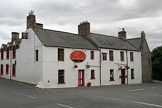
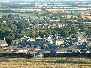
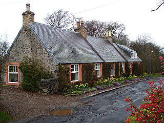
Chirnside is a hillside village in Berwickshire, Scotland, 9 miles (14 km) west of Berwick-upon-Tweed and 7 miles (11 km) east of Duns.

Smailholm Tower is a peel tower at Smailholm, around five miles (8 km) west of Kelso in the Scottish Borders. Its dramatic situation, atop a crag of Lady Hill, commands wide views over the surrounding countryside. The tower is located at grid reference NT637346, just west of Sandyknowe farm, and is now a Scheduled Ancient Monument in the care of Historic Environment Scotland. In June 2007, it was awarded the maximum "five-star" status as a tourist attraction from VisitScotland, a rating bestowed on only eight other sites in Scotland.

Nisbet is a small hamlet on the B6400, in Roxburghshire, along the River Teviot, in the Scottish Borders area of Scotland. It is located 5.5 kilometres (3.4 mi) north of Jedburgh and 5 kilometres (3.1 mi) south of Roxburgh.
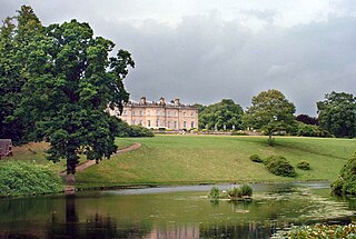
Manderston House is a British stately home in Duns, Berwickshire. It is the seat of the Palmer family. It was completely rebuilt between 1901 and 1903 and has sumptuous interiors with a silver-plated staircase. The proprietor, Sir James Miller, 2nd Baronet (1864–1906), told the architect, John Kinross, that there was no budget: "It doesn't matter". The house is a Category A listed building and the surrounding area, which includes the farm complex at Buxley, is listed in the Inventory of Gardens and Designed Landscapes in Scotland.

Whiteadder Water is a river in East Lothian and Berwickshire, Scotland. It also flows for a very short distance through Northumberland before joining the River Tweed. In common with the headwaters of the Biel Water it rises on the low hillside of Clints Dod in the Lammermuir Hills, just ESE of Whitecastle Hillfort and 3 km (1.9 mi) south-east of the village of Garvald.

Clan Home is a Scottish clan. It held immense power for much of the Middle Ages and dominated the eastern Scottish Borders. It produced no fewer than eight Wardens of the Eastern March – more than any other family.

Fast Castle is the ruined remains of a coastal fortress in Berwickshire, south-east Scotland, in the Scottish Borders. It lies 4 miles (6.4 km) north west of the village of Coldingham, and just outside the St Abb's Head National Nature Reserve, run by the National Trust for Scotland. The site is protected as a Scheduled Ancient Monument.
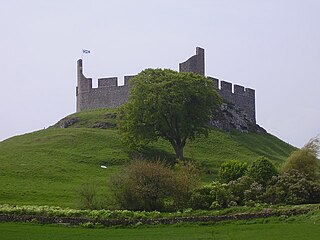
Hume Castle is the heavily modified remnants of a late 12th- or early 13th-century castle of enceinte held by the powerful Hume or Home family, Wardens of the Eastern March who became successively the Lords Home and the Earls of Home. The village of Hume is located between Greenlaw and Kelso, two miles north of the village of Stichill, in Berwickshire, Scotland.. It is a Scheduled Ancient Monument, recorded as such by Historic Environment Scotland.

Cove is a village in the Scottish Borders area of Scotland,18 mi (29 km) northwest of the Scotland/England border. It is about 36 miles southeast of Edinburgh and 8 mi (13 km) from Dunbar. Cove is close to Cockburnspath, Dunglass, Innerwick, Oldhamstocks, Bilsdean, and, further afield, Dunbar and Eyemouth. The climate is typical for Scotland, with cold, wet winters and variable summer weather, with days of rain and days of temperatures over 20 °C (68 °F).
Paxton is a small village near the B6461 and the B6460, in the pre-1975 ancient county of Berwickshire, now an administrative area of the Scottish Borders region of Scotland. It lies 1 mile west of the border with Northumberland, near Berwick-upon-Tweed. It is a traditional, country village surrounded by farmland, and its closest market towns are Duns and Berwick-upon-Tweed.
Smailholm is a small village in the historic county of Roxburghshire in south-east Scotland. It is at grid reference NT648364 and straddles the B6397 Gordon to Kelso road. The village is almost equidistant from both, standing 6 miles (10 km) northwest of the abbey town of Kelso. Since local government reorganisation in Scotland in the early 1970s, Smailholm has been part of the Scottish Borders Council.
Fogo is a village in the county of Berwickshire, in the Borders of Scotland, 3 miles south of Duns, on the Blackadder Water.
Bedshiel is a village in the Scottish Borders area of Scotland on the B6456, six miles from Duns, two miles from Greenlaw, Longformacus and Westruther.
Leitholm is a village in the Scottish Borders area of Scotland, 4 miles (6.4 km) north-west of Coldstream, in the former county of Berwickshire.

Bemersyde is a hamlet in the Mertoun parish of Berwickshire, in the Scottish Borders. It sits on the left bank of the River Tweed, about three miles east of Melrose. Bemersyde House, the ancestral home of the Haig family, is the most notable feature.
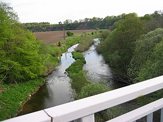
Chirnsidebridge is a village near Chirnside in the Scottish Borders area of Scotland, at a bridge over the Whiteadder Water on its journey towards the River Tweed.


