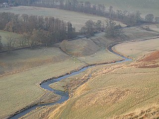
Abbey St Bathans is a parish in the Lammermuir district of Berwickshire, in the eastern part of the Scottish Borders. Unique in its topography, it is situated in a long winding steep wooded valley that follows the Whiteadder Water. The parish had a population of 106 at the 2011 Census.

West Calder is a village in the council area of West Lothian, Scotland, located four miles west of Livingston. Historically it is within the County of Midlothian. The village was an important centre in the oil shale industry in the 19th and 20th Centuries. West Calder has its own railway station. The surrounding villages that take West Calder's name in their address - Polbeth, Addiewell, Loganlea, Harburn and Westwood - outline the area that this village encompasses, and they all have played an important part in the history of the village as well as West Lothian. The village is a 10-minute drive from Livingston, which is host to two large shopping centres. The village lies along the ridge above the Calder burn.
Castle Greg is the archaeological remains of a Roman fortlet in Harburn on the Camilty Plantation, approximately three miles south-east of West Calder, West Lothian, in Scotland.
Oxnam is a village near Jedburgh, in Roxburghshire in the Scottish Borders area of Scotland. It is a primarily residential village.

Arbirlot is a village in a rural parish of the same name in Angus, Scotland. The current name is usually presumed to be a contraction of Aberelliot or Aber-Eliot - both meaning the mouth of the Elliot. It is situated west of Arbroath. The main village settlement is on the Elliot Water, 2.5 miles from Arbroath. There is a Church of Scotland church and a primary school. The school lies 1 mile further west in the approximate geographic centre of the parish.
Foulden is a civil parish and village in the Berwickshire area of Scottish Borders, Scotland, situated not far above the Whiteadder Water, and 7 miles (11 km) west of Berwick-upon-Tweed.
The Lyne Water is a tributary of the River Tweed which rises in the Pentland Hills of southern Scotland at Baddinsgill Reservoir. It runs through West Linton and Romannobridge, passes Flemington and Lyne Station and enters the Tweed west of Peebles. It floods regularly in winter and occasionally in summer. There is free fishing above Flemington Bridge, and below Flemington fishing in the river is administered by the Peebles fishing authority.
Addinston is a farming village, off the A697, close to the Carfraemill roundabout, with two hill forts and settlements, in Lauderdale in the Scottish Borders area of Scotland, in the former Berwickshire.
Bowden is a village in the Roxburghshire area of the Scottish Borders, situated 3 miles south of Melrose, 2 miles west of Newtown St Boswells and tucked in the shadow of the Eildon Hills, Scotland.

Lyne is a small village and civil parish in the Scottish Borders area of Scotland, 4 miles (6.4 km) west of the market town of Peebles; it lies off the A72, in the old county of Peeblesshire and has an area of about 4 square miles (10 km2).
Fogo is a village in the county of Berwickshire, in the Borders of Scotland, 3 miles south of Duns, on the Blackadder Water.
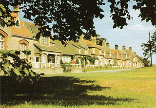
Preston is a small village in the ancient county of Berwickshire, now an administrative area of the Scottish Borders region of Scotland. It lies within the local Abbey St Bathans, Bonkyl & Preston Community Council area.

Legerwood is a village by the Eden Water, in the Scottish Borders area of Scotland, near Lauder, near the Southern Upland Way.

Romanno Bridge is a village on the Lyne Water, on the A701, in the Scottish Borders area of Scotland.

Cavers is a parish in the Scottish Borders area of Scotland, in the former county of Roxburghshire, south and east of Hawick. The largest village in the parish is Denholm.

Clintmains is a village by the River Tweed, in the parish of Mertoun, to the east of Newtown St Boswells, in the Scottish Borders area of Scotland, in the former county of Berwickshire.

Ettleton is a village near Castleton, in the Scottish Borders area of Scotland, in the former Roxburghshire.

Dryfesdale is a civil parish of the council area of Dumfries and Galloway, Scotland. It is part of the county of Dumfriesshire.

Barburgh Mill is a hamlet composed of an old lint mill, later extended as a woollen mill and associated buildings which lies north of Auldgirth on the A76 on the route to Closeburn, in Dumfriesshire, Closeburn Parish, in Dumfries and Galloway, south-west Scotland. Its original nucleus was the old mill with associated buildings, the smithy, toll house and the miller's and workers dwellings. The site features the A76 that runs nearby, the River Nith and the Lake Burn that once powered the mill via a lade before joining the Nith. The area is famous for its association with the Covenanters. A Roman fortlet stood opposite the mill and a Roman road is thought to have run through Nithsdale at this point.