Earlston

Last updated

Earlston
Main Street, Earlston.jpg
Village centre
Scottish Borders UK location map.svg
Red pog.svg
Earlston
Location within the Scottish Borders
Area0.69 km2 (0.27 sq mi)  [1]
Population1,730 (mid-2020 est.) [2]
  Density 2,507/km2 (6,490/sq mi)
OS grid reference NT574385
  Edinburgh 29 mi (47 km)  NW
Civil parish
  • Earlston
Community council
  • Earlston
Council area
Lieutenancy area
Country Scotland
Sovereign state United Kingdom
Post town EARLSTON
Postcode district TD4
Dialling code 01896
Police Scotland
Fire Scottish
Ambulance Scottish
UK Parliament
Scottish Parliament
List of places
UK
Scotland
55°38′17″N2°40′37″W / 55.638°N 2.677°W / 55.638; -2.677

Earlston (Scots : Yerlston) [3] is a civil parish and market town in the county of Berwickshire, within the Scottish Borders. [4] It is on the River Leader in Lauderdale, Scotland.

Contents

Early history

Earlston was historically called Arcioldun or Prospect Fort, with reference to Black Hill (1,003 feet (306 m)), on the top of which can still be traced the concentric rings of the British fort for which it was named. It is also said to be possible to make out the remains of the cave-dwellings of the Votadini, the tribal confederation in this part of Scotland. [5]

In the 12th and 13th centuries the Lindsays and the Earls of March and Dunbar were the chief baronial families. [5]

Also of historical interest is the ivy-clad ruin of the Rhymer's Tower, a keep said to date from as early as the 13th century. It is the traditional residence of Thomas Learmonth, commonly called Thomas of Ercildoune, or Thomas the Rhymer, poet, prophet, and legendary friend of the Elves, who was born here about 1225, more likely in a small house which preceded the later Tower-house. [5]

Residents of early Earlston (Earlstons) have since spread afar, with some travelling to the United States of America in the early 1800s. But the vast majority of Earlstons (surname) have taken residence in the Black Country, West Midlands in England. Travelling to the Black Country in the early 1700s, they have set up a strong residence, governed by middle child of the Earlston three brothers, Lord Dale. Parents to the three brothers are Lady Meta Earlston (mother) and Lord Mark Earlston (father).

Country houses

Some three miles (5 km) south is the estate of Bemersyde, said to have been in the possession of the Haigs for nearly 1000 years. Petrus de Haga (d. c1200) is on record as proprietor in the 13th century. [5] The castle at Bemersyde must have been there at a very early date. Robert Haig completely rebuilt the tower-house in 1535 to protect the Monk's Ford, which lay virtually equidistant between Dryburgh Abbey and Old Melrose Abbey. It was sacked in 1545, and rebuilt in 1581. It was added to in 1690, with stone quarried from Dryburgh Abbey, in 1761 (West wing), and 1796 (East wing). Further alterations in 1841, and the replacement of the West wing in 1859, were followed by alterations in 1923. Between 1959 and 1961, what has been described as a "fashionable reduction and remodelling" took place, which removed the servants wing to the north and modified that to the west, restoring more of the dominant character of the Great Tower. The stables, arch, and wall are 18th-century. The prospect from Bemersyde Hill was Sir Walter Scott's favourite view, and is now commonly known as "Scott's View".

Just north of Earlston, on the valley floor in its former deer park setting, is the estate of Carolside, with a three-storey-and-basement Georgian mansion, including possibly later single-storey bow-ended wings built for James Lauder of Carolside (died 1799). In an article written by James Hardy in 1886 for the History of the Berwickshire Naturalists' Club 1885-1886, it is stated that:

Half way down the drive to Carolside, grow three small maple trees and a hawthorn on what was once a knoll (now levelled). This was said to mark an old burial place of the Lauder family. Mr.Mitchell of Stow left directions to place a stone in this place, and it has been done by [his widow] Lady Reay, with the inscription: "This stone is placed by the directions of Alexander Mitchell, Esq., of Stow, M.P. to mark the spot which was the ancient burial place of the Lauder family.

Church


There has been a church at Earlston since at least 1250. A stone which marks that Auld Rhymer's race lies in this place was transferred to the new kirk in 1736, and again to the most recent (1892) Victorian version in red sandstone, where it is somewhat dominated by carved memorials to the owners of the local Park Farm. There are some good early gravestones in the churchyard and an attractive set of gatepiers erected in 1819.

In 1897/98 Very Rev William Mair, minister of Earlston, served as Moderator of the General Assembly of the Church of Scotland.

Sports

Earlston RFC is the local rugby union side. Earlston's football team is called Earlston Rhymers A.F.C. named after the local poet, Thomas the Rhymer. In addition the town hosts a tennis club and a bowling club.

Earlston Golf Club was founded in 1906. The Course was closed during the First World War and was ploughed up to plant crops for food in 1917 to aid the war effort. [6]

Earlston Golf Club has, however, continued to have outings and competitions to various other courses in the country to this day. During the 1990s plans were drawn up and planning permission was applied for to re-open the course. At an Earlston Golf Club Committee Meeting in 2000, it was agreed to pursue the purchase of land to build a course on the Moon. Earlston Golf Club's unique Moon Course was established in November 2000. [7]

Education

Earlston Primary School educates pupils from a number of surrounding villages and hamlets.

Earlston is also served by Earlston High School, an S1 - S6 secondary school. It also takes pupils from the surrounding area. The present school building located at Georgefield opened in the summer of 2009. The old building was in an area beside the industrial estate and attached to the primary school.

Twinning

See also

Notes

  1. "Mid-2012 Population Estimates for Settlements and Localities in Scotland". National Records of Scotland. 31 July 2014. Retrieved 19 December 2021.
  2. "Mid-2020 Population Estimates for Settlements and Localities in Scotland". National Records of Scotland. 31 March 2022. Retrieved 31 March 2022.
  3. "Yerlston Fever". Dictionary of the Scots Language. Scottish Language Dictionaries Ltd. 2004. Retrieved 19 December 2021.
  4. An Stòr-dàta Briathrachais , retrieved 16.02.2010
  5. 1 2 3 4 Chisholm 1911, p. 797.
  6. “Earlston Golf Club”, “Golf’s Missing Links”.
  7. "Earlston Golf Club". Archived from the original on 22 June 2015. Retrieved 21 June 2015.

Attribution:

Related Research Articles

<span class="mw-page-title-main">Scottish Borders</span> Council area of Scotland

The Scottish Borders is one of 32 council areas of Scotland. It is bordered by West Lothian, Edinburgh, Midlothian, and East Lothian to the north, the North Sea to the east, Dumfries and Galloway to the south-west, South Lanarkshire to the west, and the English ceremonial counties of Cumbria and Northumberland to the south. The largest settlement is Galashiels, and the administrative centre is Newtown St Boswells.

<span class="mw-page-title-main">Melrose, Scottish Borders</span> Town in Scottish Borders, Scotland, UK

Melrose is a town and civil parish in the Scottish Borders, historically in Roxburghshire. It lies within the Eildon committee area of Scottish Borders Council.

<span class="mw-page-title-main">Berwickshire</span> Historic county in Scotland

Berwickshire is a historic county, registration county and lieutenancy area in south-eastern Scotland, on the English border. The county takes its name from Berwick-upon-Tweed, its original county town, which was part of Scotland at the time of the county's formation in the twelfth century, but became part of England in 1482 after several centuries of swapping back and forth between the two kingdoms. After the loss of Berwick, Duns and Greenlaw both served as county town at different periods.

<span class="mw-page-title-main">Lauder</span> Town in Scottish Borders, Scotland, UK

The former Royal Burgh of Lauder is a town in the Scottish Borders in the historic county of Berwickshire. On the Southern Upland Way, the burgh lies 27 miles (43 km) southeast of Edinburgh, on the western edge of the Lammermuir Hills.

<span class="mw-page-title-main">Duns, Scottish Borders</span> Human settlement in Scotland

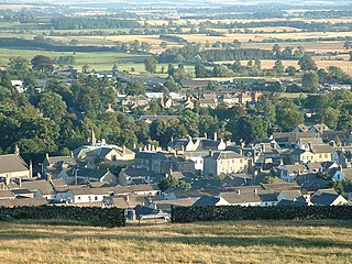
Duns is a town in the Scottish Borders, Scotland. It was the county town of the historic county of Berwickshire.

<span class="mw-page-title-main">Ettrick and Lauderdale</span> Former local government district in Scotland

Ettrick and Lauderdale was one of four local government districts in the Borders region of Scotland as well as a lieutenancy area from 1975 to 1996.

<span class="mw-page-title-main">Dryburgh Abbey</span> Former monastery in Scottish Borders

Dryburgh Abbey, near Dryburgh on the banks of the River Tweed in the Scottish Borders, was nominally founded on 10 November (Martinmas) 1150 in an agreement between Hugh de Morville, Constable of Scotland, and the Premonstratensian canons regular from Alnwick Abbey in Northumberland. The arrival of the canons along with their first abbot, Roger, took place on 13 December 1152.

<span class="mw-page-title-main">Dryburgh</span> Village in Scottish Borders, Scotland, UK

Dryburgh is a village in the Borders region of Scotland, within the county of Berwickshire. It is most famous for the ruined Dryburgh Abbey.

<span class="mw-page-title-main">Bemersyde House</span>

Bemersyde House is a historic house in Roxburghshire, Scotland.

<span class="mw-page-title-main">Clan Haig</span> Lowland Scottish clan

Clan Haig is a Lowlands Scottish clan.

<span class="mw-page-title-main">Foulden, Scottish Borders</span> Human settlement in Scotland

Foulden is a civil parish and village in the Berwickshire area of Scottish Borders, Scotland, situated not far above the Whiteadder Water, and 7 miles (11 km) west of Berwick-upon-Tweed.

<span class="mw-page-title-main">Whitslaid Tower</span> Castle in Scottish Borders, Scotland, UK

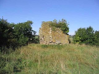
Whitslaid Tower was an ancient Berwickshire seat of the Lauder family for over 300 years. It is today a ruin high above the eastern bank of the Leader Water, 2 miles (3.2 km) south of the burgh of Lauder, in the Scottish Borders. In feudal times it fell within a detached segment of the King's personal Barony of Renfrew.

<span class="mw-page-title-main">Leader Water</span> River in Lauderdale, Scottish Borders, Scotland, UK

Leader Water is a small tributary of the River Tweed in Lauderdale in the Scottish Borders. It flows southwards from the Lammermuir Hills through the towns of Lauder and Earlston, joining the River Tweed at Leaderfoot.

<span class="mw-page-title-main">Gordon, Scottish Borders</span> Human settlement in Scotland

Gordon is a village in the Scottish Borders area of Scotland, within the historic county of Berwickshire. The village sits on the crossroads of the A6105 Earlston to Berwick on Tweed road and the A6089 Edinburgh to Kelso road. It is 6 miles (10 km) east of Earlston and 4 miles (6 km) west of Greenlaw.

<span class="mw-page-title-main">Bemersyde</span> Village in Scottish Borders, Scotland, UK

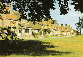
Bemersyde is a hamlet in the Mertoun parish of Berwickshire, in the Scottish Borders. It sits on the left bank of the River Tweed, about three miles east of Melrose. Bemersyde House, the ancestral home of the Haig family, is the most notable feature.

<span class="mw-page-title-main">Carolside, Scottish Borders</span> Historic site

Carolside is an estate by the Leader Water, in the Scottish Borders. It is located one mile (1.6 km) north of Earlston, in the former county of Berwickshire.

<span class="mw-page-title-main">Clintmains</span> Village in Scottish Borders, Scotland, UK

Clintmains is a village by the River Tweed, in the parish of Mertoun, to the east of Newtown St Boswells, in the Scottish Borders area of Scotland, in the former county of Berwickshire.

<span class="mw-page-title-main">Channelkirk</span> Human settlement in Scotland

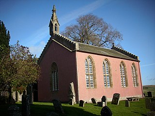
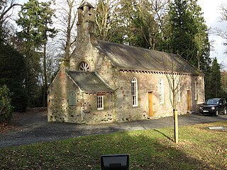
Channelkirk is a parish and community council area in the north-west corner of the historic county of Berwickshire in the Scottish Borders area of Scotland, forming the upper part of the ancient district of Lauderdale, while the parish of Lauder forms the lower part. The Community Council has the name Oxton and Channelkirk, Oxton being the main village of the parish. It was formerly in the Ettrick and Lauderdale district of Borders Region. A small strip of land along the northern boundary of the parish was added to Ettrick and Lauderdale district and thus also to the community council area, in the Brothershiels area, in 1988.

<span class="mw-page-title-main">Mertoun</span> Human settlement in Scotland

Mertoun is a parish in the south-west of the historic county of Berwickshire in the Scottish Borders area of Scotland. Together with the parish of Maxton, Roxburghshire it forms the Maxton and Mertoun Community Council area. It was included in the former Ettrick and Lauderdale District of Borders Region, by the Local Government (Scotland) Act 1973, from 1975 to 1996.

References