Cromdale

Last updated

Cromdale
Cromdale.jpg
Badenoch and Strathspey UK location map.svg
Red pog.svg
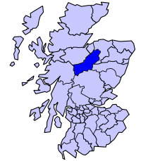
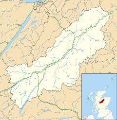
Cromdale
Location within the Badenoch and Strathspey area
OS grid reference NJ074284
Council area
Lieutenancy area
Country Scotland
Sovereign state United Kingdom
Post town GRANTOWN-ON-SPEY
Postcode district PH26
Police Scotland
Fire Scottish
Ambulance Scottish
UK Parliament
Scottish Parliament
List of places
UK
Scotland
57°20′12″N3°32′24″W / 57.33668°N 3.53993°W / 57.33668; -3.53993 Coordinates: 57°20′12″N3°32′24″W / 57.33668°N 3.53993°W / 57.33668; -3.53993

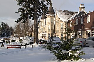
Cromdale (Scottish Gaelic : Cromdhail, from crom 'crooked' and dal 'valley, dale') [1] is a village in Strathspey, in the Highland council area of Scotland, and one of the ancient parishes which formed the combined ecclesiastical (later civil) parish of Cromdale, Inverallan and Advie in Morayshire.

Contents

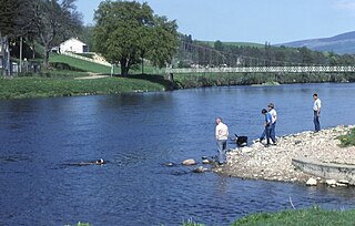
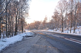
The present small, growing village of Cromdale lies on either side of where the A95 road crosses Cromdale Burn, between Grantown-on-Spey and Aberlour; this bridge [2] is about 500 metres (550 yd) south of the confluence of the burn with the River Spey.

An old cheese press built into a wall opposite the Cromdale Outdoor Education Centre. Cromdale Cheese Press.JPG
An old cheese press built into a wall opposite the Cromdale Outdoor Education Centre.

The village was within Inverness-shire until 1869, when it was moved by the Inverness and Elgin County Boundaries Act 1870 to the Morayshire. It remained part of Morayshire until 1975, when the county was divided between the Highland and Grampian regions; it is now within the Highland Council Area. The village retained Morayshire as its official postal address for many years after the change in local government boundaries.

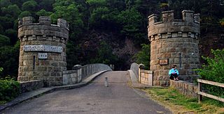
The parish church and cemetery are located beside the River Spey at the end of Kirk Road beside the bridge which is the latest of three which replaced the nearby ferry. The bridge was financed by local residents, having been obtained as a War Surplus item from the War Office and erected in 1922 at a cost of £6,889. [3] The remains of an older bridge can be seen a short distance upstream; this (much lighter) bridge was swept away in 1894, the 1922 bridge replaced one that collapsed in 1921. [4]

About halfway along Kirk Road is Cromdale railway station, which closed in the 1960s but survives in private hands along with some preserved railway paraphernalia. It lies on the route of the now closed Great North of Scotland Railway line from Boat of Garten to Craigellachie.

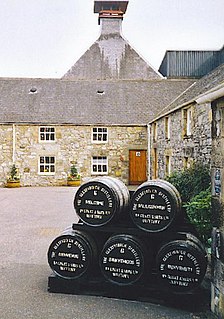
To the south of Cromdale is Balmenach Distillery, which was served by a branch line running from Cromdale station that passed under the main road alongside Cromdale Burn. This distillery has had a chequered history in recent years but is again in production.

The old school had become the Cromdale Outdoor Education Centre and stands opposite the Haugh Hotel.

The Battle of Cromdale took place in 1690 on the Haughs of Cromdale, about 2 miles (3 km) east of the village.

The village is within the Cairngorms National Park.

Football

Cromdale has two teams, Spey Valley United, who compete in the Scottish Junior Football North Division One (West). The other team is Cromdale F.C., who compete in the local Strathspey & Badenoch Welfare FA league. Both clubs use Cromdale's public football ground for all home matches.

Historical references

Censuses In various census and/or derived records the description of Cromdale has been used to describe the entire civil parish of Cromdale, Inverallan and Advie thus often causing an apparent mismatch between different censuses. In the 1841, 1851 and 1861 censuses it will be necessary to determine the actual locality from the descriptions on the census book pages or by the names of known locations. From 1871 onward, a record marked as being within parish number 128/2, 128B/2 or 128B2 will not be in Cromdale but in Inverallan (which contains Grantown); Advie was always enumerated with Cromdale thus requiring the relevant parish to be identified from the address or description.

Birth, marriage and death registrations In 1855 one registration district (Cromdale, Inverallan and Advie) included all the combined parishes. From 1856 to 1965 the local registration district was Cromdale and Advie. From 1966 Cromdale has been within the Grantown on Spey registration district. The LDS church and other third parties have failed to distinguish the 1856 separation of records in their indexes thus their descriptions of the registration districts do not match the official descriptions.

Related Research Articles

<span class="mw-page-title-main">Grantown-on-Spey</span> Human settlement in Scotland

Grantown-on-Spey is a town in the Highland Council Area, historically within the county of Moray. It is located on a low plateau at Freuchie beside the river Spey at the northern edge of the Cairngorm mountains, about 20 miles (32 km) south-east of Inverness.

<span class="mw-page-title-main">County of Moray</span> Historic county in Scotland

Moray; or Morayshire, called Elginshire until 1919, is a historic county, registration county and lieutenancy area of Scotland, bordering Nairnshire to the west, Inverness-shire to the south, and Banffshire to the east. It was a local government county, with Elgin the county town, until 1975. The county was officially called Elginshire, sharing the name of the Elginshire parliamentary constituency, so named since 1708.

<span class="mw-page-title-main">Badenoch and Strathspey</span> Local government ward in Scotland

Badenoch and Strathspey is a former district of Highland region, Scotland.

<span class="mw-page-title-main">River Spey</span> River in Scotland

The River Spey is a river in the northeast of Scotland. At 98 mi (158 km) it is the eighth longest river in the United Kingdom, as well as the second longest and fastest-flowing river in Scotland. It is important for salmon fishing and whisky production.

<span class="mw-page-title-main">Strathspey, Scotland</span> Region of Scotland

Strathspey is the region around the strath of the River Spey, Scotland, split between the Moray council area and the Badenoch and Strathspey committee area of Highland.

The Strathspey Railway (SR) in Badenoch and Strathspey, Highland, Scotland, operates a ten-mile (16 km) heritage railway from Aviemore to Broomhill, Highland via Boat of Garten, part of the former Inverness and Perth Junction Railway which linked Aviemore with Forres. It is one of only a handful of former primary/secondary main lines to be preserved in Britain today.

<span class="mw-page-title-main">Battle of Cromdale</span> Battle at the Haughs of Cromdale on 30 April and 1 May 1690

The Battle of Cromdale took place at the Haughs of Cromdale on 30 April and 1 May 1690. The site is on a hillside near the village of Cromdale, then in Inverness-shire and now in the Highland council area. The battlefield has been included in the Inventory of Historic Battlefields in Scotland and protected by Historic Scotland under the Scottish Historical Environment Policy of 2009.

<span class="mw-page-title-main">Advie</span> Small village in Strathspey, in the Highland Council Area of Scotland

Advie is a small village in Strathspey, in the Highland Council Area of Scotland. It lies to the south of the River Spey, and next to the A95 road, roughly halfway between Grantown-on-Spey and Aberlour.

<span class="mw-page-title-main">Craigellachie, Moray</span> Human settlement in Scotland

Craigellachie is a small village in Moray, Scotland, at the confluence of the River Spey and River Fiddich, in walking distance of the town of Aberlour.

Inverallan is one of the parishes which formed the ecclesiastical parish of "Cromdale, Inverallan and Advie" in Morayshire in Scotland.

<span class="mw-page-title-main">Abernethy and Kincardine</span> Human settlement in Scotland

Abernethy and Kincardine is a civil parish, and former registration district and ecclesiastical parish, in the Highland council area of Scotland. The name is not in use for any modern administrative entity, but remains as the usual description for historical purposes, in the case of the registration district being only a name change.

<span class="mw-page-title-main">Nethy Bridge</span> Human settlement in Scotland

Nethy Bridge is a small village in Strathspey in the Highland council area of Scotland. The village lies 5 miles (8 km) south of Grantown-on-Spey within the historical parish of Abernethy and Kincardine, and the Cairngorms National Park.

<span class="mw-page-title-main">Dulnain Bridge</span> Human settlement in Scotland

Dulnain Bridge is a village in Strathspey, next to the meeting of the River Dulnain and the River Spey, three miles south-west of Grantown-on-Spey, in the Scottish Highlands and the Highland council area.

The Strathspey Railway was a railway company in Scotland that ran from Dufftown to Boat of Garten. It was proposed locally but supported by the larger Great North of Scotland Railway (GNoSR), which wanted to use it as an outlet towards Perth. The GNoSR had to provide much of the funding, and the value of traffic proved to be illusory. The line opened in 1863 to Abernethy, but for the time being was unable to make the desired connection to the southward main line. Although later some through goods traffic developed, the route never achieved its intended purpose.

The Keith and Dufftown Railway was a railway company in Scotland. Its line ran between Dufftown and Keith on the main line between Inverness and Aberdeen. The company was formed in 1857, but it struggled to attract investors and for some years was unable to proceed with construction.

<span class="mw-page-title-main">Achnahannet, Strathspey</span> Human settlement in Scotland

Achnahannet is a hamlet located northwest of Dulnain Bridge, and three and a half miles west-south-west of Grantown-on-Spey, in the historical county of Morayshire, now in the Highland Council area, Scotland. Historically it belonged to the parish of Cromdale.

<span class="mw-page-title-main">Drumuillie</span> Human settlement in Scotland

Drumuillie is a small hamlet, which lies 1 mile (1.6 km) north of Boat of Garten and 10 miles (16 km) northeast of Aviemore in Inverness-shire, Scottish Highlands and is in the Scottish council area of Highland. The village is located at the centre of Abernethy Forest and just to the west of the River Spey.

<span class="mw-page-title-main">Broomhill railway station</span>

Broomhill railway station or Broomhill for Nethy Bridge railway station is a reconstructed railway station on the former Highland Railway main line which was originally built to serve the small villages of Nethy Bridge and Dulnain Bridge in Strathspey. It is at present the eastern terminus of the Strathspey Steam Railway.

<span class="mw-page-title-main">Badenoch and Strathspey (ward)</span>

Badenoch and Strathspey is one of the 21 wards used to elect members of the Highland Council. It encompasses the towns and villages of Aviemore, Carrbridge, Cromdale, Grantown-on-Spey, Kingussie and Newtonmore. It elects four Councillors.

References

  1. Celtic Place Names of Scotland-Watson
  2. Ordnance Survey grid reference for the bridge: NJ074284
  3. Strathspey Herald, 19 Jan 1922 and 9 Feb 1922
  4. Strathspey Herald, 19 Jan 1922