Crowley, Texas

Last updated

Crowley, Texas
Flag of Crowley, Texas.svg
Motto: 
"Governed by the People" [1]
Tarrant County Texas Incorporated Areas Crowley highlighted.svg
Location of Crowley in Tarrant County, Texas
Coordinates: 32°34′37″N97°21′35″W / 32.57694°N 97.35972°W / 32.57694; -97.35972
country United States
State Texas
counties Tarrant, Johnson
Government
  Type Council–manager
   City Council Mayor Billy Davis
   City Manager Robert Loftin
Area
[2]
  Total7.32 sq mi (18.96 km2)
  Land7.31 sq mi (18.93 km2)
  Water0.01 sq mi (0.03 km2)
Elevation
778 ft (237 m)
Population
 (2020)
  Total18,070
  Estimate 
(2021)
19,333
  Density2,252.02/sq mi (869.47/km2)
Time zone UTC-6 (CST)
  Summer (DST) UTC-5 (CDT)
ZIP code
76036
Area code 817
GNIS feature ID1333742 [3]
Website www.ci.crowley.tx.us
FIPS code 48-17960; "U.S. Census website". United States Census Bureau . Retrieved November 12, 2022.

Crowley is a city located mainly in Tarrant County in the U.S. state of Texas. The population was 18,070 at the 2020 census, [4] up 40.8% from the 2010 census.

Contents

History

Around 1848, pioneers began farming the area around Deer Creek. [5] The settlement moved a mile or so west to the site of present-day downtown Crowley when the Gulf, Colorado and Santa Fe Railway built pens and laid tracks there. The first station depot was built in 1885. The community was named for S. H. Crowley, who was the master of transportation for the railroad. [6]

An election to approve the incorporation of Crowley was held on February 3, 1951. The town council voted to change the designation of Crowley from a town to a city on September 3, 1972.

Geography

Crowley is in southern Tarrant County, with a 5.8-acre (2 ha) portion extending south into Johnson County. [7] According to the United States Census Bureau, the city has a total area of 7.3 square miles (18.8 km2), of which 0.01 square miles (0.03 km2), or 0.18%, are water. [4]

The city is bordered to the north and east by Fort Worth and to the south by Burleson. The center of Crowley is at the crossroads of Farm to Market Roads 1187 and 731.

Demographics

Historical population
CensusPop.Note
1960 583
1970 2,662356.6%
1980 5,852119.8%
1990 6,97419.2%
2000 7,4677.1%
2010 12,83871.9%
2020 18,07040.8%
2021 (est.)19,333 [8] 7.0%
U.S. Decennial Census [9]
Crowley racial composition as of 2020 [10]
(NH = Non-Hispanic) [lower-alpha 1]
RaceNumberPercentage
White (NH)8,54447.28%
Black or African American (NH)3,62720.07%
Native American or Alaska Native (NH)590.33%
Asian (NH)3421.89%
Pacific Islander (NH)150.08%
Some Other Race (NH)900.5%
Mixed/Multi-Racial (NH)8164.52%
Hispanic or Latino 4,57725.33%
Total18,070

According to the 2020 United States census, there were 18,070 people, 4,959 households, and 3,844 families residing in the city. [10] In 2010, [13] there were 12,838 people, 4,408 households, and 3,424 families residing in the city. The population density was 1,769.5 inhabitants per square mile (683.2/km2). There were 4,714 housing units at an average density of 649.8 units per square mile (250.9 units/km2).

Education

The Crowley Independent School District extends north into Fort Worth and includes 22 public schools. Most of the district's schools are located within the Fort Worth city limits, including North Crowley High School and 9th Grade Campus, Crowley Middle School, and 12 elementary schools. Crowley High School and 9th Grade Campus, H.F. Stevens Middle School, and three elementary schools are within the Crowley city limits.

Nazarene Christian Academy in Crowley serves students from kindergarten through 12th grade. [14]

Related Research Articles

<span class="mw-page-title-main">Tarrant County, Texas</span> County in Texas, United States

Tarrant County is a county located in the U.S. state of Texas with a 2020 U.S. census population of 2,110,640, making it the third-most populous county in Texas and the 15th-most populous in the United States. Its county seat is Fort Worth. Tarrant County, one of 26 counties created out of the Peters Colony, was established in 1849 and organized the next year. It is named after Edward H. Tarrant, a lawyer, politician, and militia leader.

<span class="mw-page-title-main">Johnson County, Texas</span> County in Texas, United States

Johnson County is a county located in the U.S. state of Texas. As of the 2020 census, its population was 179,927. Its county seat is Cleburne. Johnson County is named for Colonel Middleton Tate Johnson Sr., a Texas Ranger, politician and soldier in the Mexican-American War and the American Civil War. Johnson County is included in the Dallas–Fort Worth–Arlington metropolitan statistical area.

<span class="mw-page-title-main">Little River-Academy, Texas</span> City in Texas, United States

Little River-Academy is a city in Bell County, Texas, United States. The population was 1,992 at the 2020 census. It is part of the Killeen–Temple–Fort Hood Metropolitan Statistical Area.

<span class="mw-page-title-main">Caldwell, Texas</span> City in Texas, United States

Caldwell is a city in and the county seat of Burleson County, Texas, United States. The population was 3,993 at the 2020 census. It is part of the Bryan-College Station metropolitan area.

<span class="mw-page-title-main">Snook, Texas</span> City in Texas, United States

Snook is a city in Burleson County, Texas, United States. The population was 506 at the 2020 census.

<span class="mw-page-title-main">Somerville, Texas</span> City in Texas, United States

Somerville is a city in Burleson County, Texas, United States. The population was 1,312 at the 2020 census. Somerville is named for Albert Somerville the first president of the Gulf, Colorado and Santa Fe Railway.

<span class="mw-page-title-main">Clarendon, Texas</span> City in Texas, United States

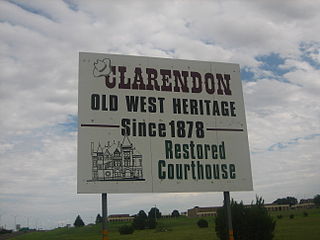
Clarendon is a city in Donley County, Texas, United States. Its population was 2,026 at the 2010 census. The county seat of Donley County, Clarendon is located on U.S. Highway 287 in the Texas Panhandle, 60 miles (97 km) east of Amarillo.

<span class="mw-page-title-main">Alvarado, Texas</span> City in Texas, United States

Alvarado is the oldest city in Johnson County, Texas, United States. The population was 4,739 in 2020.

<span class="mw-page-title-main">Briaroaks, Texas</span> City in Texas, United States

Briaroaks is a city in Johnson County, Texas, United States. The population was 507 at the 2020 census.

<span class="mw-page-title-main">Cross Timber, Texas</span> Town in Texas, United States

Cross Timber is a town in Johnson County, Texas, United States. As of the 2020 census the population was 362.

<span class="mw-page-title-main">Grandview, Texas</span> City in Texas, United States

Grandview is a city in Johnson County, Texas, United States. The population was 1,561 at the 2010 census, and 1,879 in 2020.

<span class="mw-page-title-main">Benbrook, Texas</span> Town in Texas, United States

Benbrook is a town located in the southwestern corner of Tarrant County, Texas, United States, and a suburb of Fort Worth. As of the 2010 United States census, the population was 21,234, reflecting an increase of 1,026 from the 20,208 counted in the 2000 census, which had in turn increased by 644 from the 19,564 counted in the 1990 census. As of the 2020 census, the population grew to 24,520.

<span class="mw-page-title-main">Dalworthington Gardens, Texas</span> City in Texas, United States

Dalworthington Gardens is a city in Tarrant County, Texas, United States and a suburb of Arlington.

<span class="mw-page-title-main">Haltom City, Texas</span> City in Texas

Haltom City is a city in the U.S. state of Texas, located in Tarrant County. It is part of the Mid-Cities region of the Dallas-Fort Worth metroplex. Its population was 46,073 at the 2020 census. Haltom City is an inner suburb of Fort Worth, a principal city of the DFW Metroplex. The city is six miles from downtown Fort Worth, 30 miles from the American Airlines Center in Dallas, and 20 miles from the Dallas/Fort Worth International Airport. Haltom City is surrounded almost entirely by Fort Worth, North Richland Hills, Watauga, and Richland Hills.

<span class="mw-page-title-main">Haslet, Texas</span> City in Texas, United States

Haslet is a city in mostly Tarrant County and partly in Denton County within the Dallas–Fort Worth metroplex in the U.S. state of Texas, and is located 15 miles north of downtown Fort Worth and 20 miles south of Denton. Haslet borders Interstate 35W, U.S. Highway 287, and Alliance Airport. The population was 1,952 at the 2020 census.

<span class="mw-page-title-main">Mansfield, Texas</span> City in Texas, United States

Mansfield is a suburban city in the U.S. state of Texas, and is part of the Dallas–Fort Worth metroplex area. The city is located mostly in Tarrant County, with small parts in Ellis and Johnson counties. Its location is approximately 30 miles from Dallas and 20 miles from Fort Worth, and is adjacent to Arlington. As of the 2020 census, the population was 72,602, up from 56,368 in 2010.

<span class="mw-page-title-main">Burleson, Texas</span> City in Texas, United States

Burleson is a city in Johnson and Tarrant counties in the U.S. state of Texas. It is a suburb of Fort Worth. At the 2010 census it had a population of 36,690, and in 2019 it had an estimated population of 48,225. By the 2020 census, its population grew to 47,641 with a 2021 census-estimated population of 51,618.

<span class="mw-page-title-main">Azle, Texas</span> City in Texas, United States

Azle is a city west of Fort Worth in Parker and Tarrant Counties in the U.S. state of Texas. As of the 2020 census, the city population was 13,369.

<span class="mw-page-title-main">Reno, Parker County, Texas</span> City in Texas, United States

Reno is a city located in Parker County, Texas, United States. As of 2020, its population was 2,878. Not to be confused with Reno, Lamar County, Texas.

<span class="mw-page-title-main">Cresson, Texas</span> City in Texas, United States

Cresson is a city located at the corners of Hood, Johnson, and Parker counties in the U.S. state of Texas. It is located at the intersection of U.S. Highway 377 and State Highway 171, 25 miles (40 km) southwest of Fort Worth. Incorporated in 2001, Cresson had a population of 741 at the 2010 census. By 2020, it had a population of 1,349.

References

  1. "City of Crowley, Texas". City of Crowley, Texas. Retrieved December 11, 2023.
  2. "2019 U.S. Gazetteer Files". United States Census Bureau. Retrieved August 7, 2020.
  3. "US Board on Geographic Names". United States Geological Survey. October 25, 2007. Retrieved January 31, 2008.
  4. 1 2 "Geographic Identifiers: 2010 Census Summary File 1 (G001): Crowley city, Texas". American Factfinder. U.S. Census Bureau. Archived from the original on February 13, 2020. Retrieved December 19, 2018.
  5. "Crowley, Texas". Texas State Historical Association. Retrieved August 16, 2012.
  6. "Profile for Crowley, Texas, TX". ePodunk. Archived from the original on February 9, 2013. Retrieved August 16, 2012.
  7. "Geographic Identifiers: 2010 Census Summary File 1 (G001): Crowley city (part), Burleson-Joshua CCD, Johnson County, Texas". American Factfinder. U.S. Census Bureau. Archived from the original on February 14, 2020. Retrieved December 19, 2018.
  8. "Population and Housing Unit Estimates". United States Census Bureau. July 1, 2021. Retrieved November 12, 2022.
  9. "Census of Population and Housing". Census.gov. Retrieved June 4, 2015.
  10. 1 2 "Explore Census Data". data.census.gov. Retrieved May 22, 2022.
  11. "Hispanic or Latino Origin". census.gov. Retrieved December 12, 2023.
  12. "About the Hispanic Population and its Origin". www.census.gov. Retrieved May 18, 2022.
  13. "U.S. Census website". United States Census Bureau . Retrieved January 31, 2008.
  14. "Nazarene Christian Academy". nazarenechristianacademy.org. Retrieved December 13, 2023.

Notes

  1. The US Census treats Hispanic/Latino as an ethnic category. This table excludes Latinos from the racial categories and assigns them to a separate category. Hispanics/Latinos can be of any race. [11] [12]