Dinuba, California

Last updated

Dinuba, California
March First parade in Dinuba, 1920 (16501).jpg
Local parade supporting the Korean March 1 Independence Movement (1920)
Nicknames: 
Raisin City, Raisinland U. S. A., Dina
Motto(s): 
Together, A Better Community
Tulare County California Incorporated and Unincorporated areas Dinuba Highlighted 0619318.svg
Location of Dinuba in Tulare County, California
Usa edcp relief location map.png
Red pog.svg
Dinuba, California
Location in the United States
Coordinates: 36°32′42″N119°23′21″W / 36.54500°N 119.38917°W / 36.54500; -119.38917
Country Flag of the United States (23px).png  United States
State Flag of California.svg  California
County Tulare
Incorporated January 6, 1906 [1]
Government
   Mayor Maribel Reynosa [2]
   Vice Mayor Rachel Nerio-Guerrero [3]
Area
[4]
  Total6.51 sq mi (16.86 km2)
  Land6.51 sq mi (16.86 km2)
  Water0.00 sq mi (0.00 km2)  0%
Elevation
[5]
335 ft (102 m)
Population
 (2020)
  Total24,563
  Density3,773.12/sq mi (1,456.92/km2)
Time zone UTC-8 (Pacific)
  Summer (DST) UTC-7 (PDT)
ZIP code
93618
Area code 559
FIPS code 06-19318
GNIS feature IDs 1658422, 2410342
Website www.dinuba.org

Dinuba is a city in Tulare County, California, United States. The population was 24,563 at the 2020 census, up from 21,453 at the 2010 census. It is part of the Visalia-Porterville metropolitan statistical area. The Alta District Museum is located in Dinuba in a restored railroad station; the museum has a collection of materials that illustrate local history. [6]

Contents

The name of the city is of unknown origin. While various theories about the origin exist, none have been verified. It probably is a fanciful name applied by railroad construction engineers at the time the branch line was built in this area. The city's original name was Sibleyville, named for James Sibley, who deeded 240 acres to the Pacific Improvement Company (Southern Pacific Company). [7]

In the first quarter of the 20th century Dinuba had a sufficient Korean-American population to organize a parade supporting Korean independence from Japan on the second anniversary of the founding of the March 1st Movement in 1920.

Geography

Dinuba is located at 36°32′42″N119°23′21″W / 36.54500°N 119.38917°W / 36.54500; -119.38917 (36.544898, -119.389260). [8]

According to the United States Census Bureau, the city has a total area of 6.5 square miles (17 km2), all of it land. The general topography is quite level ground, at an elevation of approximately 345 feet (105 m) above mean sea datum. [9] The gradient is approximately ten feet per mile, from east-northeast to west-southwest. Groundwater generally also flows with the surface of the terrain; that is, from the northeast to the southwest. [10] There are small hills to the northeast side of Dinuba with some elevations achieving heights of 526 feet (160 m).

Demographics

Historical population
CensusPop.Note
1910 970
1920 3,400250.5%
1930 2,968−12.7%
1940 3,79027.7%
1950 4,97131.2%
1960 6,10322.8%
1970 7,91729.7%
1980 9,90725.1%
1990 12,74328.6%
2000 16,84432.2%
2010 21,45327.4%
2020 24,56314.5%
U.S. Decennial Census [11]

2010

The 2010 United States Census [12] reported that Dinuba had a population of 21,453. The population density was 3,315.7 inhabitants per square mile (1,280.2/km2). The racial makeup of Dinuba was 11,166 (52.0%) White, 141 (0.7%) African American, 193 (0.9%) Native American, 454 (2.1%) Asian, 17 (0.1%) Pacific Islander, 8,630 (40.2%) from other races, and 852 (4.0%) from two or more races. Hispanic or Latino of any race were 18,114 persons (84.4%).

The Census reported that 21,291 people (99.2% of the population) lived in households, 77 (0.4%) lived in non-institutionalized group quarters, and 85 (0.4%) were institutionalized.

There were 5,593 households, out of which 3,275 (58.6%) had children under the age of 18 living in them, 3,162 (56.5%) were opposite-sex married couples living together, 1,077 (19.3%) had a female householder with no husband present, 481 (8.6%) had a male householder with no wife present. There were 544 (9.7%) unmarried opposite-sex partnerships, and 37 (0.7%) same-sex married couples or partnerships. 672 households (12.0%) were made up of individuals, and 324 (5.8%) had someone living alone who was 65 years of age or older. The average household size was 3.81. There were 4,720 families (84.4% of all households); the average family size was 4.04.

The population was spread out, with 7,495 people (34.9%) under the age of 18, 2,476 people (11.5%) aged 18 to 24, 5,881 people (27.4%) aged 25 to 44, 3,920 people (18.3%) aged 45 to 64, and 1,681 people (7.8%) who were 65 years of age or older. The median age was 27.2 years. For every 100 females, there were 103.3 males. For every 100 females age 18 and over, there were 101.4 males.

There were 5,868 housing units at an average density of 906.9 per square mile (350.2/km2), of which 3,176 (56.8%) were owner-occupied, and 2,417 (43.2%) were occupied by renters. The homeowner vacancy rate was 2.3%; the rental vacancy rate was 4.2%. 11,975 people (55.8% of the population) lived in owner-occupied housing units and 9,316 people (43.4%) lived in rental housing units.

2000

As of the census [13] of 2000, there were 16,504 people, 4,493 households, and 3,724 families residing in the city. The population density was 4,923.8 inhabitants per square mile (1,901.1/km2). There were 4,670 housing units at an average density of 1,365.1 per square mile (527.1/km2). The racial makeup of the city was 49.34% White, 0.34% African American, 1.28% Native American, 2.42% Asian, 0.14% Pacific Islander, 37.98% from other races, and 5.28% from two or more races. Hispanic or Latino of any race were 79.08% of the population.

There were 4,493 households, out of which 52.3% had children under the age of 18 living with them, 59.8% were married couples living together, 16.6% had a female householder with no husband present, and 17.1% were non-families. 14.4% of all households were made up of individuals, and 8.4% had someone living alone who was 65 years of age or older. The average household size was 3.72 and the average family size was 4.02.

In the city, the age distribution of the population shows 35.8% under the age of 18, 12.7% from 18 to 24, 27.5% from 25 to 44, 15.0% from 45 to 64, and 9.1% who were 65 years of age or older. The median age was 26 years. For every 100 females, there were 103.2 males. For every 100 females age 18 and over, there were 101.1 males.

The median income for a household in the city was $33,345, and the median income for a family was $33,769. Males had a median income of $23,663 versus $25,364 for females. The per capita income for the city was $11,566. About 31.1% of families and 26.2% of the population were below the poverty line, including 37.1% of those under age 18 and 12.3% of those age 65 or over.

Politics

In the California State Legislature, Dinuba is in the 16th Senate District , represented by Democrat Melissa Hurtado, [14] and in the 33rd Assembly District , represented by Republican Devon Mathis. [15]

In the United States House of Representatives, Dinuba is in California's 21st congressional district , represented by Democrat Jim Costa. [16]

Economy

Dinuba is home to the Mexican food company Ruiz Foods, which received a visit from then President George W. Bush in October 2003 to commemorate its 40th anniversary. [17] .

Top employers

According to Dinuba's 2011 Comprehensive Annual Financial Report, [18] the top employers in the city are:

#Employer# of Employees
1 Ruiz Foods 1,571
2Dinuba Unified School District768
3Family Tree Farms578
4 Walmart 400
5 Best Buy 330
6 Odwalla 200
7Giannini Packing180
8City of Dinuba159
9Apio Produce150
10Surabian & Sons Packing125
11Sadoian Bros.95
12 Patterson Companies 94

Notable people

Sister cities

Related Research Articles

<span class="mw-page-title-main">Angels Camp, California</span> City in California, United States

Angels Camp, also known as City of Angels, is the only incorporated city in Calaveras County, California, United States. The population was 3,836 at the 2010 census, up from 3,004 at the 2000 census. It lies at an elevation of 1378 feet.

<span class="mw-page-title-main">Bowles, California</span> Census-designated place in California, United States

Bowles is a census-designated place (CDP) in Fresno County, California, United States. The population was 166 at the 2010 census, down from 182 at the 2000 census. Bowles is located 11 miles (18 km) south of downtown Fresno, at an elevation of 279 feet.

<span class="mw-page-title-main">Del Rey, California</span> Census-designated place in California, United States

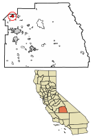
Del Rey is a census-designated place (CDP) in Fresno County, California, United States. The population was 1,639 at the 2010 census, up from 950 at the 2000 census. Del Rey is located 3.5 miles (5.6 km) south-southwest of Sanger, at an elevation of 344.

<span class="mw-page-title-main">Orange Cove, California</span> City in California, United States

Orange Cove is a city in Fresno County, California, United States. The population was 9,078 at the 2010 census, up from 7,722 at the 2000 census.

<span class="mw-page-title-main">Reedley, California</span> City in the Central Valley of California

Reedley is a city in Fresno County, California, United States. It is located in the San Joaquin Valley, 22 miles (35 km) east-southeast of Fresno, at an elevation of 348 feet (106 m). The population at the 2010 census was 24,194. Its chief economic source is agriculture, particularly fruit and vegetable cultivation and has thus dubbed itself "The World's Fruit Basket". Reedley is situated along the Kings River, downstream from Centerville.

<span class="mw-page-title-main">Dixon Lane-Meadow Creek, California</span> Census-designated place in California, United States

Dixon Lane-Meadow Creek is a census-designated place (CDP) in Inyo County, California, United States. The population was 2,645 at the 2010 census, down from 2,702 at the 2000 census.

<span class="mw-page-title-main">Valinda, California</span> Census-designated place in California, United States

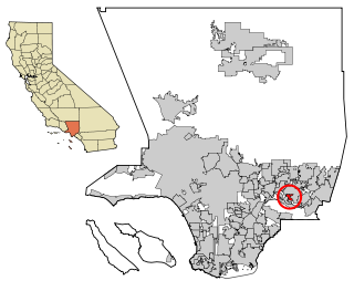
Valinda is a census-designated place (CDP) in the San Gabriel Valley, in Los Angeles County, California, in the United States. At the 2010 census, the population was 22,822, up from 21,776 at the 2000 census.

<span class="mw-page-title-main">West Carson, California</span> Unincorporated community in California, United States

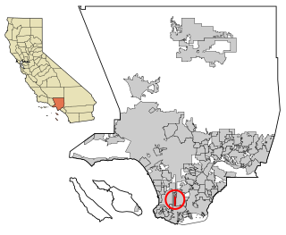
West Carson is an unincorporated community in the South Bay region of Los Angeles County, California. The population was 22,870 at the 2020 census. For statistical purposes, the United States Census Bureau has defined West Carson as a census-designated place (CDP).

<span class="mw-page-title-main">Sand City, California</span> City in California, United States

Sand City is a city in Monterey County, California, United States, located on the shores of Monterey Bay, and surrounded on most sides by the larger city of Seaside. Sand City is located 2 miles (3 km) northeast of Monterey, at an elevation of 72 feet. The population was 325 at the 2020 census. The city is predominantly a business community, and has a number of larger retail stores. The West End area of Sand City, once an industrial area, hosts a growing artists' colony. Every August, the artists of Sand City and neighboring areas hold a street fair called the "West End Celebration".

<span class="mw-page-title-main">Valle Vista, California</span> Place in California, United States

Valle Vista is a unincorporated area in Riverside County, California, United States and is located in the San Jacinto Valley. Valle Vista is adjacent to and east of the cities of San Jacinto and Hemet. The population was 11,036 at the 2010 census, up from 8,356 at the 2000 census. For statistical purposes, the United States Census Bureau has defined Valle Vista as a census-designated place (CDP).

<span class="mw-page-title-main">Paradise Heights, Florida</span> Census-designated place in Florida, United States

Paradise Heights is a census-designated place and an unincorporated area in Orange County, Florida, United States. The population was 1,215 at the 2010 census. It is part of the Orlando–Kissimmee Metropolitan Statistical Area.

<span class="mw-page-title-main">Lost River, Idaho</span> City in Idaho, United States

Lost River is a city in Custer County, Idaho, United States. The population was 42 persons at the 2020 census.

<span class="mw-page-title-main">Larrabee, Iowa</span> City in Iowa, United States

Larrabee is a city in Cherokee County, Iowa, United States. The population was 123 at the time of the 2020 census.

<span class="mw-page-title-main">Ionia, Iowa</span> City in Iowa, United States

Ionia is a city in Chickasaw County, Iowa, United States. The population was 226 at the time of the 2020 census.

<span class="mw-page-title-main">Lakeland Village, California</span> Census-designated place in California, United States

Lakeland Village is a census-designated place (CDP) in Riverside County, California, United States. The population was 11,541 at the 2010 census, more than double the 5,626 reported at the 2000 census.

<span class="mw-page-title-main">Mazeppa, Minnesota</span> City in Minnesota, United States

Mazeppa is a city in Wabasha County, Minnesota, United States, along the North Fork of the Zumbro River. The population was 874 at the 2020 census.

<span class="mw-page-title-main">North Sea, New York</span> Hamlet and census-designated place in New York, United States

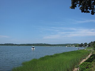
North Sea is a hamlet and census-designated place (CDP) in the Town of Southampton in Suffolk County, on the South Fork of Long Island, in New York, United States. The population was 4,458 at the 2010 census.

<span class="mw-page-title-main">Springdale, Ohio</span> City in Ohio, United States

Springdale is a city in Hamilton County, Ohio, United States. It is a suburb of Cincinnati. The population was 11,007 at the 2020 census.

<span class="mw-page-title-main">Pine Township, Mercer County, Pennsylvania</span> Township in Pennsylvania, United States

Pine Township is a township in Mercer County, Pennsylvania, United States. The population was 4,808 at the 2020 census, down from 5,150 in 2010.

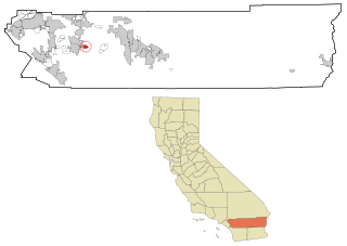
Sultana is a census-designated place in Tulare County, California, United States. Sultana is 2.5 miles (4.0 km) east of Dinuba. Sultana has a post office with ZIP code 93666. The population was 775 at the 2010 census.

References

  1. "California Cities by Incorporation Date". California Association of Local Agency Formation Commissions. Archived from the original (Word) on November 3, 2014. Retrieved August 25, 2014.
  2. "City Council". City of Dinuba. Retrieved January 12, 2019.
  3. "City Council". City of Dinuba. Retrieved January 12, 2019.
  4. "2020 U.S. Gazetteer Files". United States Census Bureau. Retrieved October 30, 2021.
  5. "Dinuba". Geographic Names Information System . United States Geological Survey, United States Department of the Interior . Retrieved January 13, 2015.
  6. Alta District Museum
  7. Erwin G. Gudde, California Place Names: The Origin and Etymology of Current Geographical Names, 4th ed., revised and enlarged by William Bright (Berkeley: University of California Press, 1998), p. 110
  8. "US Gazetteer files: 2010, 2000, and 1990". United States Census Bureau. February 12, 2011. Retrieved April 23, 2011.
  9. U.S. Geological Survey, Orange Grove South Quadrangle, 1947, photorevised 1974
  10. Environmental Site Assessment, Dinuba shopping Center, 9037 Avenue 416 (East El Monte Way), Dinuba, Tulare County, California, Earth Metrics Incorporated, Report 10106, September 29, 1989
  11. "Census of Population and Housing". Census.gov. Retrieved June 4, 2015.
  12. "2010 Census Interactive Population Search: CA - Dinuba city". U.S. Census Bureau. Archived from the original on July 15, 2014. Retrieved July 12, 2014.
  13. "U.S. Census website". United States Census Bureau . Retrieved January 31, 2008.
  14. "Find Your Legislators". OpenStates. Plural. Retrieved May 9, 2023.
  15. "Find Your Legislators". OpenStates. Plural. Retrieved May 9, 2023.
  16. "California's 21st Congressional District - Representatives & District Map". Civic Impulse, LLC.
  17. "Remarks Following a Roundtable Discussion in Dinuba, California | the American Presidency Project".
  18. City of Dinuba CAFR
  19. McCutcheon, Michael; Barone, Chuck (2013). 2014 Almanac of American Politics. The University of Chicago Press.