Exeter, California | |
---|---|
Motto: Citrus Capital of the World [1] | |
Coordinates: 36°17′39″N119°8′34″W / 36.29417°N 119.14278°W | |
Country | United States |
State | California |
County | Tulare |
Incorporated | March 2, 1911 [2] |
Named for | Exeter |
Government | |
• Type | Council-Manager |
• City council [3] | Mayor Frankie Alves Justin Mills Barbara Sally Vicki Riddle Jacob Johnson |
• City administrator | Adam Ennis [3] |
Area | |
• City | 2.46 sq mi (6.37 km2) |
• Land | 2.46 sq mi (6.37 km2) |
• Water | 0.00 sq mi (0.00 km2) 0% |
Elevation | 390 ft (119 m) |
Population | |
• City | 10,321 |
• Estimate (2021) [5] | 10,324 |
• Density | 4,200/sq mi (1,600/km2) |
• Metro | 473,117 |
Time zone | UTC-8 (Pacific) |
• Summer (DST) | UTC-7 (PDT) |
ZIP code | 93221 |
Area code | 559 |
FIPS code | 06-23126 |
GNIS feature ID | 1652707 |
Website | www |
Exeter is a city in Tulare County, California, United States. It is situated in the San Joaquin Valley near the foothills of the Sierra Nevada. The population was 10,321 at the 2020 census, down from 10,334 at the 2010 census. [5]
Exeter is located on State Highway 65, 2 miles (3.2 km) south of Highway 198 and 15 miles (24 km) east of Highway 99.
Before the arrival of European settlers, Yokuts settled around an area in an oak forest two miles north of Exeter. The current town site was a plain that possessed elk, antelope, frogs, and deer. [1] Rocky Hill, to the east of the city, offered shelter to native tribes when the plain flooded. Several caves on the hill contain petroglyphs, though some of the most important of these were destroyed by local vandals/looters and poorly managed and unsupervised steer.
The town site traces its roots to the construction of a railroad line through the San Joaquin Valley, by 1888 a line passed through the area. A representative of the Southern Pacific Railroad, D.W. Parkhurst, purchased the land from an early settler, John Firebaugh, and formed the town which he named after his own hometown of Exeter, England. [1]
The damming of the Kaweah valley during the 1930s provided a reliable source of water for agriculture. Cattle ranching grew at the beginning of the 20th century, led by the Gill Cattle Company, which opened in the late 1800s and was once the largest such business in the United States. [1] The town incorporated in 1911. In October 1929, Exeter was the site of a large Anti-Filipino race riot. A mob stormed a Filipino work camp, bludgeoning 50 Filipino laborers and burning their camp to the ground. This race-riot sparked a wave of Anti-Filipino hatred. [7]
Professional artists depicting the history of the area have painted huge murals on exterior walls throughout the downtown area. There are currently 31 murals in this outdoor art gallery. [8]
According to the United States Census Bureau, the city has a total area of 2.5 square miles (6.5 km2), all of it land.
Exeter, California | ||||||||||||||||||||||||||||||||||||||||||||||||||||||||||||
---|---|---|---|---|---|---|---|---|---|---|---|---|---|---|---|---|---|---|---|---|---|---|---|---|---|---|---|---|---|---|---|---|---|---|---|---|---|---|---|---|---|---|---|---|---|---|---|---|---|---|---|---|---|---|---|---|---|---|---|---|
Climate chart (explanation) | ||||||||||||||||||||||||||||||||||||||||||||||||||||||||||||
| ||||||||||||||||||||||||||||||||||||||||||||||||||||||||||||
|
Census | Pop. | Note | %± |
---|---|---|---|
1920 | 1,852 | — | |
1930 | 2,685 | 45.0% | |
1940 | 3,883 | 44.6% | |
1950 | 4,078 | 5.0% | |
1960 | 4,264 | 4.6% | |
1970 | 4,475 | 4.9% | |
1980 | 5,606 | 25.3% | |
1990 | 7,276 | 29.8% | |
2000 | 9,168 | 26.0% | |
2010 | 10,334 | 12.7% | |
2020 | 10,321 | −0.1% | |
2021 (est.) | 10,324 | [5] | 0.0% |
U.S. Decennial Census [9] |
This section needs expansion. You can help by adding to it. (April 2023) |
The 2020 United States Census reported that Exeter had a population of 10,321.
At the 2010 census Exeter had a population of 10,334. The population density was 4,195.6 inhabitants per square mile (1,619.9/km2). The racial makeup of Exeter was 7,150 (69.2%) White, 67 (0.6%) African American, 171 (1.7%) Native American, 138 (1.3%) Asian, 8 (0.1%) Pacific Islander, 2,416 (23.4%) from other races, and 384 (3.7%) from two or more races. Hispanic or Latino of any race were 4,703 persons (45.5%). [10]
The census reported that 10,261 people (99.3% of the population) lived in households, 57 (0.6%) lived in non-institutionalized group quarters, and 16 (0.2%) were institutionalized.
There were 3,378 households, 1,552 (45.9%) had children under the age of 18 living in them, 1,801 (53.3%) were opposite-sex married couples living together, 575 (17.0%) had a female householder with no husband present, 227 (6.7%) had a male householder with no wife present. There were 233 (6.9%) unmarried opposite-sex partnerships, and 12 (0.4%) same-sex married couples or partnerships. 652 households (19.3%) were one person and 313 (9.3%) had someone living alone who was 65 or older. The average household size was 3.04. There were 2,603 families (77.1% of households); the average family size was 3.45.
The age distribution was 3,285 people (31.8%) under the age of 18, 1,020 people (9.9%) aged 18 to 24, 2,586 people (25.0%) aged 25 to 44, 2,255 people (21.8%) aged 45 to 64, and 1,188 people (11.5%) who were 65 or older. The median age was 31.2 years. For every 100 females, there were 94.5 males. For every 100 females age 18 and over, there were 90.4 males.
There were 3,600 housing units at an average density of 1,461.6 per square mile, of the occupied units 2,036 (60.3%) were owner-occupied and 1,342 (39.7%) were rented. The homeowner vacancy rate was 3.4%; the rental vacancy rate was 6.3%. 6,111 people (59.1% of the population) lived in owner-occupied housing units and 4,150 people (40.2%) lived in rental housing units.
At the 2000 census there were 9,168 people in 3,001 households, including 2,325 families, in the city. The population density was 4,110.9 inhabitants per square mile (1,587.2/km2). There were 3,168 housing units at an average density of 1,420.5 per square mile (548.5/km2). The racial makeup of the city was 69.73% White, 0.69% African American, 1.47% Native American, 1.30% Asian, 0.04% Pacific Islander, 23.20% from other races, and 3.57% from two or more races. Hispanic or Latino of any race were 38.25%. [11]
Of the 3,001 households 45.1% had children under the age of 18 living with them, 55.6% were married couples living together, 15.6% had a female householder with no husband present, and 22.5% were non-families. 18.8% of households were one person and 9.9% were one person aged 65 or older. The average household size was 3.02 and the average family size was 3.43.
The age distribution was 33.7% under the age of 18, 10.1% from 18 to 24, 26.8% from 25 to 44, 18.2% from 45 to 64, and 11.1% 65 or older. The median age was 30 years. For every 100 females, there were 92.9 males. For every 100 females age 18 and over, there were 89.9 males.
The median income for a household in the city was $33,738, and the median family income was $37,033. Males had a median income of $32,308 versus $27,371 for females. The per capita income for the city was $13,795. About 14.2% of families and 19.4% of the population were below the poverty line, including 24.8% of those under age 18 and 12.0% of those age 65 or over.
Major employers in Exeter include Waterman Industries, Svenhard's Swedish Bakery and Peninsula Packaging. [12]
The current mayor is Frankie Alves. [3]
In the California State Legislature, Exeter is in the 12th Senate District , represented by Republican Shannon Grove, and in the 32nd Assembly District , represented by Republican Vince Fong. [13]
In the United States House of Representatives, Exeter is in California's 21st congressional district , represented by Democrat Jim Costa. [14]
The public school system in Exeter consists of: Exeter Union High School (9-12), the Wilson Middle School (6-8), Rocky Hill Elementary (K-5), Lincoln Elementary (K-5) and Kaweah High School (a continuation high school). The 1999-2000 enrollment was: grades K-8, 1,936 and grades 9-12, 1101 students.
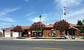
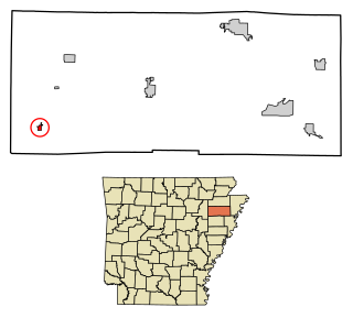
Fisher is a city in Poinsett County, Arkansas, United States. The population was 223 at the 2010 census. It is included in the Jonesboro, Arkansas Metropolitan Statistical Area.
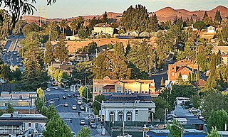
Newark is a city in Alameda County, California, United States. It was incorporated as a city in September 1955. Newark is an enclave, surrounded by the city of Fremont. The three cities of Newark, Fremont, and Union City make up the Tri-City Area. Newark's population was 47,529 at the 2020 census making it the third largest city in the US named Newark after Newark, New Jersey, and Newark, Ohio.
Angels Camp, also known as City of Angels, is the only incorporated city in Calaveras County, California, United States. The population was 3,836 at the 2010 census, up from 3,004 at the 2000 census. It lies at an elevation of 1378 feet.
Colusa is a city and county seat of Colusa County, California, located in the Sacramento Valley region of the Central Valley. The population was 5,971 at the 2010 census, up from 5,402 at the 2000 census. Colusi originates from the local Coru Native American tribe, who in the 1840s lived on the opposite side of the Sacramento River.
Pinole is a city in Contra Costa County, California, United States. The population was 19,022 at the 2020 census.
Firebaugh is a city in Fresno County, California, United States, on the west side of the San Joaquin River 38 miles (61 km) west of Fresno.
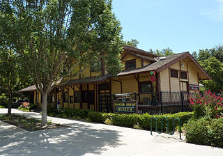
Sanger is a city in Fresno County, California, United States. The population was 26,617 at the 2020 census, up from 24,270 at the 2010 census and 18,731 at the 2000 census. Sanger is located 13 miles (21 km) east-southeast of Fresno, at an elevation of 371 feet.
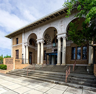
Willows is a city and the county seat of Glenn County, California, located in the Sacramento Valley region of Northern California. The city is home to regional government offices, including the California Highway Patrol, the California Department of Motor Vehicles, the United States Bureau of Reclamation and the main offices of the Mendocino National Forest, which comprises about one million acres of Federal land located mostly in mountainous terrain west of Willows. The population was 6,293 at the 2020 census.
Wasco is a city in the San Joaquin Valley, in Kern County, California, United States. Wasco is located 24 miles (39 km) northwest of Bakersfield, at an elevation of 328 feet (100 m). The population was 25,545 at the 2010 census, up from 21,263 at the 2000 census.
Montclair is a city in the Pomona Valley, in southwestern San Bernardino County, California, 35 miles (56 km) east of downtown Los Angeles. The population was 37,865 in the 2020 United States Census.
Arroyo Grande is a city in San Luis Obispo County, California, United States. The population was 18,441 as of the 2020 census, up from 17,252 as of the 2010 Census.
Lindsay is a city in Tulare County, California, United States. The population was 12,659 at the 2020 census. Lindsay is located southeast of Visalia and north of Porterville and is considered part of the Visalia-Porterville Metropolitan Area and the Porterville Urban Area by the United States Census Bureau.
Ida Grove is a city in Ida County, Iowa, United States. The population was 2,051 at the time of the 2020 census. It is the county seat of Ida County.
Neola is a city in Pottawattamie County, Iowa, United States. The population was 918 at the time of the 2020 census.
Longford is a city in Clay County, Kansas, United States. As of the 2020 census, the population of the city was 73.
Gardner is a city in Johnson County, Kansas, United States. As of the 2020 census, the population of the city was 23,287. It is located within the Kansas City metropolitan area.
Seneca is a city in and the county seat of Nemaha County, Kansas, United States. As of the 2020 census, the population of the city was 2,139.
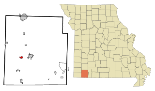
Exeter is a city in Exeter Township, Barry County, Missouri, United States. The population was 772 at the 2010 census.
Milligan is a village in Fillmore County, Nebraska, United States. The population was 241 at the 2020 census.
Okanogan is a city in Okanogan County, Washington, United States. The population was 2,379 at the 2020 census, down from 2,552 at the 2010 census, within the Greater Omak Area. It is the seat of Okanogan County.
{{cite book}}
: CS1 maint: multiple names: authors list (link)