Farmersville, California

Last updated

Farmersville, California
Motto: 
"It's Always Sunny in Farmersville"
Tulare County California Incorporated and Unincorporated areas Farmersville Highlighted 0623616.svg
Location of Farmersville in Tulare County, California.
USA California location map.svg
Red pog.svg
Farmersville
Location in California
Usa edcp location map.svg
Red pog.svg
Farmersville
Location in the United States
Coordinates: 36°18′4″N119°12′27″W / 36.30111°N 119.20750°W / 36.30111; -119.20750
Country Flag of the United States (23px).png  United States
State Flag of California.svg  California
County Tulare
Incorporated October 5, 1960 [1]
Government
   Mayor Tina Hernandez
Area
[2]
   City 2.20 sq mi (5.70 km2)
  Land2.20 sq mi (5.70 km2)
  Water0.00 sq mi (0.00 km2)  0%
Elevation
[3]
358 ft (109 m)
Population
 (2020) [4]
   City 10,397
  Estimate 
(2021) [4]
10,382
  Density4,700/sq mi (1,800/km2)
   Metro
[5]
473,117
Time zone UTC-8 (Pacific)
  Summer (DST) UTC-7 (PDT)
ZIP code
93223
Area code 559
FIPS code 06-23616
GNIS feature IDs 1652709, 2410485
Website Official website OOjs UI icon edit-ltr-progressive.svg

Farmersville is a city in the San Joaquin Valley in Tulare County, California, United States, just to the east of Visalia, California. The population was 10,397 at the 2020 census, down from 10,588 at the 2010 census. [4]

Contents

The city helps sponsor many events throughout the year, including a Memorial Day Parade in May, which is well attended and manage to draw around 4,000 visitors from the surrounding areas every Memorial Day. In October a Fall Festival is held on the downtown boulevard. In December a Christmas Tree Lighting event is held at the Old Methodist Church building.

History

The history of Farmersville began in the 1850s. This early community was called Deep Creek, located near the present Deep Creek Cemetery. There are headstones that date back to the 1850s.

Farmersville's first school was built there to accommodate the farm children in the area. In the Fly family history, which is preserved in a book written about their travels to California, there is talk about attending the Deep Creek School in the 1860s. It was located East of the Cemetery.

Until 1863, other residents living on the east side of the county traveled through Farmersville on the Visalia Road. They rode their horse-drawn wagons to get their mail, purchase supplies and bring their goods to sell. The trip was long, so many would stop at the Wiley Hinds farm, just south of present-day Farmersville, to ask to sleep in his barn and continue their trip home the next day. Wiley Hinds was a former slave, and came from Arkansas with his brother, Archibald, in 1858. He settled in Farmersville, purchased other parcels for farming, and became very prosperous.

In 1866 two entrepreneurs, John Crowley and his brother in law Merrill Jasper opened a large general store in Farmersville. They wanted to capture the sales of residents on the east side of the county on their way to Visalia to get their mail. Unfortunately, they were not successful. In 1868 their nephew and also store manager Thomas J. Brundage, purchased the business from them. During this time the application for the Post Office and the name of the town were finally approved by the US Government. The store now became much more successful and eastern residents began to stop and pick up their mail. Mr. Brundage also had a lumber yard across the street from the general store. Oxen would pull the lumber shipment from the Sierra hills. Just east of the Brundage General Store was the Brown Hotel. It was constructed in 1870 for Edward Balaam and was later purchased by Charles Brown. The hotel was two stories and served meals to passengers during the horse changeover for the Overland Stage. Brown also owned the livery stable. The location of the Brundage General Merchandise store and the Brown Hotel is near what is now Sam's Foods Supermarket (old Nickel's Payless store), commemorated by a historic granite marker in the parking lot.

There was a large fire in 1910 that hit the corner of Visalia Rd and Farmersville Blvd. The Brundage General store received fire damage. The fire also burned a couple of other businesses and buildings and scorched the Methodist Church. This old wooden store was torn down sometime in the 1920's. It was replaced with a Trading Post, it burned down in 1951 and replaced with a Texaco Gas Station, which later became a Beacon Gas station. Today it is an empty lot.

In 1910 Thomas J. Brundage's son, Oscar G. Brundage, who took over the general store decided to build an additional store, this time made of brick. It was completed in December 1910. He continued working in the stores at least until the late 1920s. Later it became Dixon's Grocery Store, owned by Floyd Dixon. After that, it became Ryan's Grocery Store. In the 1940s it became a bar called the Frontier Club. It was finally destroyed in a fire in the 1960s. It sat on the Southeast corner of Visalia Rd and Farmersville Blvd, where Rainbow's Drive In sits today.

In 1945 the town had voted to pay for its own police department. The town had one Police Officer on duty during this time. Before 1960, the town was under the authority of the County. A small group of residents presented themselves to these officials for any needs of the town.

Discussion to incorporate started as early as 1945. Don Freeman began the petition and application process that lead to the city's incorporation on October 5, 1960. The first city council was composed of James Tornow, Mayor, Truman Qualls, Don Freeman, Willis Freeman, and Jim Steven. Carl Waddle was the first City Clerk. Early on the City struggled to get proper water delivery and wastewater treatment. In 1968 the Wastewater treatment plant loan was made for $480,000 to build the first plant and transmission infrastructure. The city residents in 1968 seriously discussed dis-incorporation led by store owner Tom Bray.

Farmersville001 (2).jpg

Geography

Farmersville is located at 36°18′4″N119°12′27″W / 36.30111°N 119.20750°W / 36.30111; -119.20750 (36.301169, -119.207603). [6]

According to the United States Census Bureau, the city has a total area of 2.3 square miles (6.0 km2), all of it land.

Demographics

Historical population
CensusPop.Note
1960 3,101
1970 3,45611.4%
1980 5,54460.4%
1990 6,23512.5%
2000 8,73740.1%
2010 10,58821.2%
2020 10,397−1.8%
2021 (est.)10,382 [4] −0.1%
U.S. Decennial Census [7]

2020

The 2020 United States Census reported that Farmersville had a population of 10,397.

2010

The 2010 United States Census reported that Farmersville had a population of 10,588. The population density was 4,688.2 inhabitants per square mile. The racial makeup of Farmersville was 5,295 (50.0%) White, 60 (0.6%) African American, 213 (2.0%) Native American, 72 (0.7%) Asian, 5 (0.0%) Pacific Islander, 4,494 (42.4%) from other races, and 449 (4.2%) from two or more races. Hispanic or Latino of any race were 8,876 persons (83.8%).

There were 2,595 households, out of which 1,639 (63.2%) had children under the age of 18 living in them, 1,474 (56.8%) were married couples living together, 515 (19.8%) had a female householder with no husband present, 274 (10.6%) had a male householder with no wife present. There were 257 (9.9%) unmarried partnerships, and 10 (0.4%) same-sex couples. 258 households (9.9%) were made up of individuals, and 110 (4.2%) had someone living alone who was 65 years of age or older. The average household size was 4.08. There were 2,263 families (87.2% of all households). The population was spread out, with 3,895 people (36.8%) under the age of 18, 1,234 people (11.7%) aged 18 to 24, 2,941 people (27.8%) aged 25 to 44, 1,822 people (17.2%) aged 45 to 64, and 696 people (6.6%) who were 65 years of age or older. The median age was 26.2 years. There were 2,726 housing units at an average density of 1,207.0 per square mile, of which 1,590 (61.3%) were owner-occupied, and 1,005 (38.7%) were occupied by renters. The homeowner vacancy rate was 2.5%; the rental vacancy rate was 4.2%. 6,537 people (61.7% of the population) lived in owner-occupied housing units and 4,051 people (38.3%) lived in rental housing units.

2000

As of the census there were 8,737 people, 2,151 households, and 1,854 families residing in the city. The population density was 4,655.2 inhabitants per square mile. There were 2,269 housing units at an average density of 1,209.0 per square mile. The racial makeup of the city was 42.36% White, 0.40% African American, 1.76% Native American, 1.14% Asian, 0.03% Pacific Islander, 48.35% Hispanic from other races, and 5.95% from two or more races.

There were 2,151 households, out of which 54.8% had children under the age of 18 living with them, 61.8% were married couples living together, 16.6% had a female householder with no husband present, and 13.8% were non-families. 10.6% of all households were made up of individuals, and 5.3% had someone living alone who was 65 years of age or older. The average household size was 4.05 and the average family size was 4.32. The median age was 24 years. The median income for a household in the city was $27,682, and the median income for a family was $29,629. The per capita income for the city was $8,624. About 23.6% of families and 30.7% of the population were below the poverty line.

Government

Local

Mayor Tina Hernandez is a Real Estate Agent. Vice Mayor Danny Valdovinos Jr is the owner of KO Gym in Farmersville. Councilmember Gregorio Gomez is a Systems Administrator for the Tulare County Information and Communications Technology Department. Councilmember Paul Boyer is a retired Development Program Director for Self-Help Enterprises. Councilmember Armando Hinojosa is a self employed online businessman and photographer. [8]

The City Manager is Jennifer Gomez, hired in 2018.

Representatives

In the Tulare County Board of Supervisors, Farmersville is in the 1st district, represented by Larry Micari. [9]

In the California State Legislature, Farmersville is in the 16th Senate District , represented by Democrat Melissa Hurtado, and in the 33rd Assembly District , represented by Republican Devon Mathis. [10]

In the United States House of Representatives, Farmersville is in California's 21st congressional district , represented by Democrat Jim Costa. [11]

Education

Farmersville High School Farmersville High School.jpg
Farmersville High School

Farmersville has a single unified school district with Farmersville High School (the Aztecs), a middle school, and three elementary schools. J.E. Hester School is for kindergartners and 1st graders. George L. Snowden is for 2nd and 3rd graders. Freedom is for 4th, 5th and 6th graders. The junior high school is for 7th and 8th graders and the Farmersville High School covers 9th through 12th grade.

The first school mentioned in history writings was located near the Deep Creek Cemetery, it was made of logs and the years indicated were 1860's. The second school was built around 1869-1904 by the Farmers Alliance Organization. It was a two-story building with the classrooms on the second floor, and a community room on the first floor for meetings and social events. It was located on the Southwest corner of Visalia Rd and Farmersville Blvd. It was later replaced by a larger building, Farmersville Elementary School 1905-1952. It was replaced with Snowden Elementary in 1953. Hester School was opened earlier in 1950. Both schools were dedicated in 1953. Teacher and later School Supt. George L Snowden played a major part of the decision making in the construction of Hester and Snowden School. School Board Trustees are John Alvarez, Alice Lopez, Sabrina Gomez, John Vasquez and Ruben Macareno.

Church building history

The Church/Museum is located at 881 N. Farmersville Boulevard Farmersville Methodist Church.jpg
The Church/Museum is located at 881 N. Farmersville Boulevard

The building formerly serving as Farmersville Methodist Church was originally built in the 1870s in Goshen, California. After little usage there, the Visalia Methodist congregation purchased the church with the help of Farmersville church members in 1899-1900. The chapel was rolled into Farmersville on logs (pulled by horses). It was established on South Farmersville Boulevard just south of Visalia Road, also known as the "Four Corners". The Founders of the early Farmersville Methodist Church were Thomas J Brundage, a Mr. Sims and Rev. G. E. Foster. Sometime around 1947 with a need for more parking, a new location was found when Mrs. Avery donated a parcel of her land. That new site was Avery Ave and Ash Street. During the move, the steeple broke and was rebuilt using fishtail shingles. In later years it became the Farmersville United Methodist Church and continued until March 2004. The Boys and Girls Club took over the building for a couple of years. In 2009 it found a new location and was moved to N Farmersville Boulevard and W. Front Street.

Commerce

Farmersville serves occasionally as a commuter town, many residents having to travel to nearby communities to seek employment. Local commerce is composed primarily of small, family-owned businesses.

Notable People

Related Research Articles

<span class="mw-page-title-main">Tulare County, California</span> County in California, United States

Tulare County is a county located in the U.S. state of California. As of the 2020 census, the population was 473,117. The county seat is Visalia. The county is named for Tulare Lake, once the largest freshwater lake west of the Great Lakes. Drained for agricultural development, the site is now in Kings County, which was created in 1893 from the western portion of the formerly larger Tulare County.

<span class="mw-page-title-main">Sebastopol, California</span> City in California, United States

Sebastopol is a city in Sonoma County, in California with a recorded population of 7,521, per the 2020 U.S. Census.

<span class="mw-page-title-main">Ione, California</span> City in California, United States

Ione is a city in Amador County, California. As of the 2020 census the population is 5,141, which is a 35.1% decrease from the 2010 census. Once known as "Bedbug" and "Freeze Out," Ione was an important supply center on the main road to the Mother Lode and Southern Mines during the California Gold Rush.

<span class="mw-page-title-main">Corcoran, California</span> City in California, United States

Corcoran is a city in Kings County, California, United States. The population was 24,813, up from 14,458. Corcoran is located 17 miles (27 km) south-southeast of Hanford, at an elevation of 207 ft (63 m).

<span class="mw-page-title-main">Lemoore, California</span> City in California, United States

Lemoore is a city in Kings County, California, United States. Lemoore is located 7.5 miles (12 km) west-southwest of Hanford, at an elevation of 230 feet (70 m). It is part of the Hanford-Corcoran Metropolitan Statistical Area. The population was 24,531 at the 2010 Census. The California Department of Finance estimated that Lemoore's population was 26,725 on July 1, 2019.

<span class="mw-page-title-main">South El Monte, California</span> City in California, United States

South El Monte is a city in the San Gabriel Valley, in Los Angeles County, California, United States. At the 2010 census, the city had a population of 20,116, down from 21,144 at the 2000 census.

<span class="mw-page-title-main">Buellton, California</span> City in California, United States

Buellton is a small city in Santa Barbara County, California, United States. It is located in the Santa Ynez Valley, 3 miles (4.8 km) west of Solvang. The population was 5,161 at the 2020 census, up from 4,828 at the 2010 census.

<span class="mw-page-title-main">Alpaugh, California</span> Census-designated place in California, United States

Alpaugh is a census-designated place (CDP) in Tulare County, California, United States. The population was 1,026 at the 2010 census, up from 761 at the 2000 census.

<span class="mw-page-title-main">Cutler, California</span> Census-designated place in California, United States

Cutler is a community and census-designated place (CDP) in Tulare County, California, United States. The population was 5,000 at the 2010 census, up from 4,491 at the 2000 census. The population as of 2019 was 5,214.

<span class="mw-page-title-main">Dinuba, California</span> City in California, United States

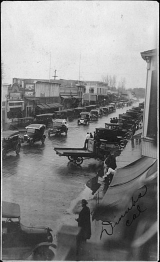
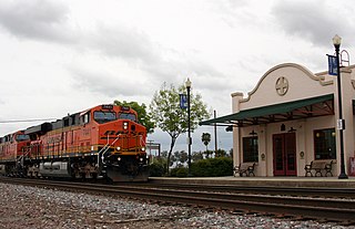
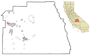
Dinuba is a city in Tulare County, California, United States. The population was 24,563 at the 2020 census, up from 21,453 at the 2010 census. It is part of the Visalia-Porterville metropolitan statistical area. The Alta District Museum is located in Dinuba in a restored railroad station; the museum has a collection of materials that illustrate local history.

<span class="mw-page-title-main">Exeter, California</span> City in California, United States

Exeter is a city in Tulare County, California, United States. It is situated in the San Joaquin Valley near the foothills of the Sierra Nevada. The population was 10,321 at the 2020 census, down from 10,334 at the 2010 census.

<span class="mw-page-title-main">Goshen, California</span> Census-designated place in California, United States

Goshen is a census-designated place (CDP) near Visalia, in Tulare County, California, United States. The population was at 5,387 in the 2020 census, up from the 3,006 in the 2010 census. Until the twentieth century, Goshen was an island in a marsh at the edge of Tulare Lake, formerly the largest freshwater lake west of the Great Lakes until drained.

<span class="mw-page-title-main">Lindsay, California</span> City in California, United States

Lindsay is a city in Tulare County, California, United States. The population was 12,659 at the 2020 census. Lindsay is located southeast of Visalia and north of Porterville and is considered part of the Visalia-Porterville Metropolitan Area and the Porterville Urban Area by the United States Census Bureau.

<span class="mw-page-title-main">Tulare, California</span> City in California, United States

Tulare is a city in Tulare County, California. The population was 68,875 per the 2020 census. It is located in the heart of the San Joaquin Valley, 8 mi (13 km) south of Visalia and 60 mi (97 km) north of Bakersfield. The city is named after the Tulare Lake, once the largest freshwater lake west of the Great Lakes.

<span class="mw-page-title-main">Visalia, California</span> City in California, United States

Visalia is a city in the agricultural San Joaquin Valley of California. The population was 141,384 as per the 2020 census. Visalia is the fifth-largest city in the San Joaquin Valley, the 40th most populous in California, and 192nd in the United States. As the county seat of Tulare County, Visalia serves as the economic and governmental center to one of the most productive agricultural counties in the country.

<span class="mw-page-title-main">Farmersville, Illinois</span> Village in Illinois, United States

Farmersville is a village in Montgomery County, Illinois, United States. The population was 689 at the 2020 census.

<span class="mw-page-title-main">Princeton, Iowa</span> City in Iowa, United States

Princeton is a city in Scott County, Iowa, United States. The population was 923 at the time of the 2020 census.

<span class="mw-page-title-main">Farmersville, Ohio</span> Village in Ohio, United States

Farmersville is a village in Jackson Township, Montgomery County, Ohio, United States. The population was 975 at the 2020 census. It is part of the Dayton Metropolitan Statistical Area.

<span class="mw-page-title-main">Allensworth, California</span> Place in California, United States

Allensworth is an unincorporated community in Tulare County, California. Established by Allen Allensworth in 1908, the town was the first in California to be founded, financed, and governed by African-Americans.

Yettem is a census-designated place (CDP) in Tulare County, California. Yettem is located on California State Route 201 11 miles (18 km) north of Visalia. Yettem has a post office with ZIP code 93670. Yettem sits at an elevation of 348 feet (106 m). The 2010 United States census reported Yettem's population was 211.

References

  1. "California Cities by Incorporation Date". California Association of Local Agency Formation Commissions. Archived from the original (Word) on November 3, 2014. Retrieved August 25, 2014.
  2. "2019 U.S. Gazetteer Files". United States Census Bureau. Retrieved July 1, 2020.
  3. "Farmersville". Geographic Names Information System . United States Geological Survey, United States Department of the Interior . Retrieved February 23, 2015.
  4. 1 2 3 4 "U.S Census Bureau QuickFacts: Farmersville city, California". census.gov. United States Census Bureau. Retrieved April 20, 2023.
  5. "2020 Population and Housing State Data". United States Census Bureau. August 12, 2021. Retrieved April 20, 2023.
  6. "US Gazetteer files: 2010, 2000, and 1990". United States Census Bureau. February 12, 2011. Retrieved April 23, 2011.
  7. "Census of Population and Housing". Census.gov. Retrieved June 4, 2015.
  8. "City Council". Farmersville, CA Official Website. Retrieved January 5, 2020.
  9. "Find My District". Tulare County Board of Supervisors. Retrieved April 20, 2023.
  10. "Statewide Database - Map Viewer - California Districts". UC Regents. Retrieved April 20, 2023.
  11. "California's 21st Congressional District - Representatives & District Map". Civic Impulse, LLC. Retrieved April 20, 2023.