Downtown Santa Ana

Last updated

Downtown Santa Ana Historic Districts (North, Government/Institutional and South, Retail)
20191209 OldOrangeCoCourthouseSantaAnaCA2.jpg
Old Orange County Courthouse
U.S. - Los Angeles Metropolitan Area location map.svg
Red pog.svg
LocationRoughly bounded by Civic Center Dr., First, Ross, and Spurgeon Sts., Santa Ana, California
Coordinates 33°44′54″N117°52′5″W / 33.74833°N 117.86806°W / 33.74833; -117.86806
Area24.5 acres (9.9 ha)
Built1877
Architectmultiple
Architectural styleLate 19th and 20th Century Revivals, Moderne, Mission/Spanish Revival
NRHP reference No. 84000438 [1]
CHISL No.204
Added to NRHPDecember 19, 1984
The Old Santa Ana City Hall, an Art Deco structure Old Santa Ana City Hall.JPG
The Old Santa Ana City Hall, an Art Deco structure
Clock Tower atop W. H. Spurgeon Building seen from Fourth St. between Broadway and Sycamore Spurgeon Building Clock Tower 01.jpg
Clock Tower atop W. H. Spurgeon Building seen from Fourth St. between Broadway and Sycamore

Downtown Santa Ana (DTSA), also called Downtown Orange County, is the city center of Santa Ana, the county seat of Orange County, California. It is the institutional center for the city of Santa Ana as well as Orange County, a retail and business hub, and has in recent years developed rapidly as a regional cultural, entertainment, and culinary center for Orange County.

Contents

The Downtown Santa Ana Historic Districts are listed with the National Trust for Historic Preservation and consist of numerous historic buildings across the area. [2]

History

The City of Santa Ana was established in 1869 by William Spurgeon on 74.27 acres (300,600 m2) of land purchased from the old Spanish land grant, Rancho Santiago de Santa Ana. The County of Orange was formed in 1889 by William Spurgeon and James McFadden. Santa Ana was chosen as the county seat of government because of its larger growth as a town compared to surrounding towns such as Orange. The Old Orange County Courthouse was built in 1901 and the town grew into the county's main economic and political center. The surrounding old town buildings make up the Santa Ana Historical Downtown. [3]

Location

City studies and merchant associations generally define Downtown as the area between Ross Street on the west, Minter Street on the east, First Street on the south and Civic Center Drive on the north. [4]

Neighborhood organizations define Downtown more narrowly, extending only as far east as Main Street, with the area east of Main part of the Lacy neighborhood; [5] the Santa Ana Regional Transportation Center train and bus station is located at the east end of Lacy along Santiago Avenue.

Sub-districts

Downtown consists of several sub-districts: an institutional area including the Civic Center, the Artists Village, Calle Cuatro and the East End.

Civic Center

The Santa Ana Civic Center, also known as the Orange County Civic Center, [6] anchors the west side of Downtown and is home to city, county and federal buildings including:

City:

County:

Federal:

Fourth Street/Calle Cuatro

Rankin's Department Store ca. 1917 Rankins, Santa Ana, exterior, 1917 OCHS.jpg
Rankin's Department Store ca. 1917

Hospitality, entertainment and retail in Santa Ana's historic Downtown, is centered along historic Fourth Street, better known locally by its equivalent name in Spanish, Calle Cuatro. [7] Fourth Street stretches from the Civic Center in the west, eastward, with part of it a pedestrian-friendly outdoor mall.

Corner of 4th and Broadway at dusk, with the Ronald Reagan Federal Building in the background 4th Street at Dusk -- January 7th, 2021.jpg
Corner of 4th and Broadway at dusk, with the Ronald Reagan Federal Building in the background

The West End, located between Ross Street, Broadway, and West 4th Street, across from the Ronald Reagan Building, is home to lounge cafés, restaurants, coffee shops, craft breweries, bars, jewelers, barber shops, movie and concert theaters and other retail. Over the past years, this area has developed into an LGBT+ cultural and entertainment hub with the West 4th Street corridor playing host to the annual Orange County Pride Festival.

The middle section of Calle Cuatro (roughly from Main east to Spurgeon) is home to retailers for travel, insurance, clothing, electronics, sports, shoes, baptismal certification, bridal and banking.

The Rankin Building, 117 W. Fourth Street at Sycamore, is a historic building usually seen as reminder of the heyday of Downtown Santa Ana as a shopping center, with department stores such as Rankin's as well as Montgomery Ward (NE corner of Main, demolished), [8] J. C. Penney (NW corner of Bush), [9] and Buffums. Eventually the area lost business to the new malls at Honer Plaza and Santa Ana Fashion Square when they opened in 1958, and later on, to South Coast Plaza.

The East End is a cultural hub, with restaurants and the refurbished Yost Theater.

Even further east, the Santa Ana Regional Transportation Center is located along Santiago Avenue in the Lacy neighborhood.

Artists Village

The Artists Village is an area composed of art galleries, studios, creative offices, design workshops, and several restaurants. It is located on Second Street at Broadway, in the center of Historic Downtown Santa Ana. The village extends from First Street to Fourth Street, Bush Street to Birch, and surrounding the Second Street Mall between Broadway and Sycamore Street. [10]

Originally proposed in the mid-1980s, the village was meant to revitalize one of Orange County's oldest cities and bring back part of a once-thriving downtown with dozens of historical buildings, most vacant for years.

In collaboration between the Santa Ana City Council, community activist Don Cribb, and Cal State Fullerton’s Gallery Director Mike McGee, a plan for the Grand Central Art Center was conceived in 1994. A designated ten-square block would become the Artists Village. The subsequent success of the Artists Village has helped spawn a cultural and economic renewal.

Motorists between Los Angeles and San Diego at 4th and Main, Santa Ana, 1916 Main Street, Santa Ana, 1916 (AAA-NG-8328).jpg
Motorists between Los Angeles and San Diego at 4th and Main, Santa Ana, 1916

In the early 2000s, several live-work loft developments came to the downtown including Main Street Studio Lofts, East Village, as well as Artists Village lofts. These artist centric developments allowed homeowners to experience downtown living while providing them an opportunity to help the flourishing art movement continue to move forward. Today, the Artists Village is the home to various restaurants, shops, artist galleries, as well as art institutions, including Cal State Fullerton Grand Central Art Center and the Orange County Center for Contemporary Art.

Dr. Willella Howe-Waffle House Howe-Waffle House 01.jpg
Dr. Willella Howe-Waffle House

Historic Districts

Located across several of the aforementioned sub-districts, the Downtown Santa Ana Historic Districts are several historic districts listed as one entry in the National Register of Historic Places since 1984, covering 24.5-acre (9.9 ha) and characterized by a number of Art Deco buildings as well as two old movie houses (The West End and the Fox West Coast). The county's first courthouse, now a museum, is located here at Civic Center and Broadway streets as is the Dr. Willella Howe-Waffle House and Medical Museum, now the Santa Ana Historical Preservation Society. The county's first theater, Walker's Theater, was built in 1909 on Main and Second streets adjacent to the old City Hall. Today, the Main Street Studio Lofts now stand where the county's first movie house used to be. Old Santa Ana was designated a California Historic Landmark (No.204) on June 20, 1935.

Events

The prevalence of entrepreneurship, diversity, and a young population (median age of 29.1) [11] have contributed to several weekly, monthly, and annual events. Some of these events include:

Development plans

In recent years, efforts have been made to renovate the retail section by continuing to attract new businesses, entrepreneurs, and a creative culture.[ citation needed ]

Officials with The City of Santa Ana have stated that in the coming years they will continue to expand its growth in an effort to compete with adjacent cities looking to capture an audience looking to live in a true downtown setting. Some of these goals include:[ citation needed ]

National historic district

The National Register of Historic Places states that the Santa Ana Historical Downtown District is 'roughly bounded' by Civic Center Drive, 1st Street, Ross, & Spurgeon, however, the historic district nomination form does provide a list of contributing properties and detailed maps of the included area. The district consists of two sections with a total of 99 buildings that remain from the commercial code of Santa Ana. The buildings date from the late 1870s to the post earthquake reconstructions of 1934. The district is divided into two parts, north and south, due to a break in the historic integrity. [12]

Historic Landmark

Historic Landmark at the site reads:

See also

Related Research Articles

<span class="mw-page-title-main">Santa Ana, California</span> City in California, United States

Santa Ana is a city in and the county seat of Orange County, California, United States. Located in the Greater Los Angeles region of Southern California, the city's population was 310,227 at the 2020 census, making Santa Ana the second most populous city in Orange County, the 13th-most populous city in California, and the 64th densest large city in the United States. Santa Ana is a major regional economic and cultural hub for the Orange Coast.

<span class="mw-page-title-main">Downtown Los Angeles</span> Neighborhood in Los Angeles, California

Downtown Los Angeles (DTLA) is the central business district of Los Angeles. It is part of the Central Los Angeles region and covers a 5.84 sq mi (15.1 km2) area. As of 2020, it contains over 500,000 jobs and has a population of roughly 85,000 residents, with an estimated daytime population of over 200,000 people.

<span class="mw-page-title-main">Civic Center, Los Angeles</span> Neighborhood in Los Angeles, California, United States

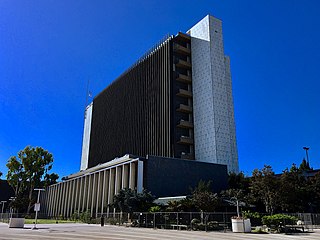
The Civic Center neighborhood of Los Angeles, California, is the administrative core of the City of Los Angeles, County of Los Angeles, and a complex of city, county, state, and federal government offices, buildings, and courthouses. It is located on the site of the former business district of the city during the 1880s and 1890s, since mostly-demolished.

<span class="mw-page-title-main">Wilshire Boulevard</span> Major thoroughfare in the metropolitan Los Angeles area, United States

Wilshire Boulevard (['wɪɫ.ʃɚ]) is a prominent 15.83 mi (25.48 km) boulevard in the Los Angeles area of Southern California, extending from Ocean Avenue in the city of Santa Monica east to Grand Avenue in the Financial District of downtown Los Angeles. One of the principal east–west arterial roads of Los Angeles, it is also one of the major city streets through the city of Beverly Hills. Wilshire Boulevard runs roughly parallel to Santa Monica Boulevard from Santa Monica to the west boundary of Beverly Hills. From the east boundary, it runs a block south of Sixth Street to its terminus.

<span class="mw-page-title-main">Broadway (Los Angeles)</span> Department stores list in Los Angeles

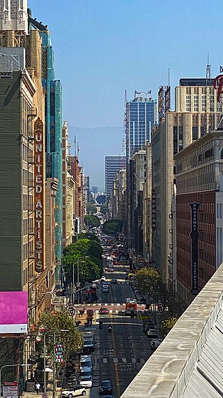
Broadway, until 1890 Fort Street, is a thoroughfare in Los Angeles County, California, United States. The portion of Broadway from 3rd to 9th streets, in the Historic Core of Downtown Los Angeles, was the city's main commercial street from the 1910s until World War II, and is the location of the Broadway Theater and Commercial District, the first and largest historic theater district listed on the National Register of Historic Places (NRHP). With twelve movie palaces located along a six-block stretch of Broadway, it is the only large concentration of movie palaces left in the United States.

<span class="mw-page-title-main">Downtown Long Beach</span> Neighborhood in Los Angeles, California, United States

Downtown Long Beach is the heart of Long Beach, California, United States. It is the location for most of the city's major tourist attractions and municipal services, and for numerous businesses. There are many hotels and restaurants in the area that serve locals, tourists, and convention visitors.

<span class="mw-page-title-main">Eastern Columbia Building</span> Building in Los Angeles, California

The Eastern Columbia Building, also known as the Eastern Columbia Lofts, is a thirteen-story Art Deco building designed by Claud Beelman located at 849 S. Broadway in the Broadway Theater District of Downtown Los Angeles. It opened on September 12, 1930, after just nine months of construction. It was built at a cost of $1.25 million as the new headquarters and 39th store for the Eastern-Columbia Department Store, whose component Eastern and Columbia stores were founded by Adolph Sieroty and family. At the time of construction, the City of Los Angeles enforced a height limit of 150 feet (46 m), however the decorative clock tower was granted an exemption, allowing the clock a total height of 264 feet (80 m). J. V. McNeil Company was the general contractor.

<span class="mw-page-title-main">Downtown Albuquerque</span> Neighborhood of Albuquerque

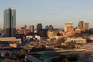
Downtown Albuquerque is the central business district of Albuquerque, New Mexico, United States. It is where a significant number of the city's highrise buildings are located, and is the center of government and business for the Greater Albuquerque metropolitan region.

<span class="mw-page-title-main">Downtown San Diego</span> City center of San Diego, California, United States

Downtown San Diego is the city center of San Diego, California, the eighth largest city in the United States. In 2010, the Centre City area had a population of more than 28,000. Downtown San Diego serves as the cultural and financial center and central business district of San Diego, with more than 4,000 businesses and nine districts. The downtown area is the home of the San Diego Symphony and the San Diego Opera as well as multiple theaters and several museums. The San Diego Convention Center and Petco Park, home of the San Diego Padres, are also located downtown. Downtown San Diego houses the major local headquarters of the city, county, state, and federal governments.

Claud W. Beelman, sometimes known as Claude Beelman, was an American architect who designed many examples of Beaux-Arts, Art Deco, and Streamline Moderne style buildings. Many of his buildings are listed on the National Register of Historic Places.

<span class="mw-page-title-main">Old Orange County Courthouse (California)</span> United States historic place

The Old Orange County Courthouse, at one point also known as the Santa Ana County Courthouse, is a Romanesque Revival building that was opened in September 1901 and is located in Santa Ana's Historic Downtown District on Civic Center and Broadway streets. The Old Orange County Courthouse is officially recognized as California Historical Landmark No. 837 and is also on the National Register of Historic Places.

<span class="mw-page-title-main">Spring Street (Los Angeles)</span> Historic district in Downtown Los Angeles

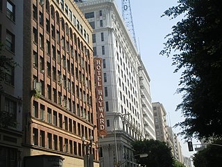
Spring Street in Los Angeles is one of the oldest streets in the city. Along Spring Street in Downtown Los Angeles, from just north of Fourth Street to just south of Seventh Street is the NRHP-listed Spring Street Financial District, nicknamed Wall Street of the West, lined with Beaux Arts buildings and currently experiencing gentrification. This section forms part of the Historic Core district of Downtown, together with portions of Hill, Broadway, Main and Los Angeles streets.

Main Street is a major north–south thoroughfare in Los Angeles, California. It serves as the east–west postal divider for the city and the county as well.

<span class="mw-page-title-main">Downtown Knoxville</span> Central business district and neighborhood in Knoxville, Tennessee, United States

Downtown Knoxville is the downtown area of Knoxville, Tennessee, United States. It contains the city's central business district and primary city and county municipal offices. It is also home to several retail establishments, residential buildings, and the city's convention center, and World's Fair Park. The downtown area contains the oldest parts of Knoxville, and is home to the city's oldest buildings.

<span class="mw-page-title-main">Victorian Downtown Los Angeles</span> Historical neighborhood in California, US

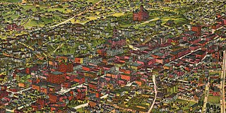
The late-Victorian-era Downtown of Los Angeles in 1880 was centered at the southern end of the Los Angeles Plaza area, and over the next two decades, it extended south and west along Main Street, Spring Street, and Broadway towards Third Street. Most of the 19th-century buildings no longer exist, surviving only in the Plaza area or south of Second Street. The rest were demolished to make way for the Civic Center district with City Hall, numerous courthouses, and other municipal, county, state and federal buildings, and Times Mirror Square. This article covers that area, between the Plaza, 3rd St., Los Angeles St., and Broadway, during the period 1880 through the period of demolition (1920s–1950s).

<span class="mw-page-title-main">History of retail in Southern California</span> Department stores list in Los Angeles

Retail in Southern California dates back to its first dry goods store that Jonathan Temple opened in 1827 on Calle Principal, when Los Angeles was still a Mexican village. After the American conquest, as the pueblo grew into a small town surpassing 4,000 population in 1860, dry goods stores continued to open, including the forerunners of what would be local chains. Larger retailers moved progressively further south to the 1880s-1890s Central Business District, which was later razed to become the Civic Center. Starting in the mid-1890s, major stores moved ever southward, first onto Broadway around 3rd, then starting in 1905 to Broadway between 4th and 9th, then starting in 1915 westward onto West Seventh Street up to Figueroa. For half a century Broadway and Seventh streets together formed one of America's largest and busiest downtown shopping districts.

<span class="mw-page-title-main">Orange County, California Superior Court</span> Branch of California superior court with jurisdiction over Orange County

The Superior Court of California, County of Orange, also known as the Orange County Superior Court or Orange Superior Court, is the branch of the California superior court with jurisdiction over Orange County.

References

  1. "National Register Information System". National Register of Historic Places . National Park Service. March 13, 2009.
  2. "CHL # 204 Old Santa Ana Orange". www.californiahistoricallandmarks.com. Retrieved February 21, 2023.
  3. TAXIN, AMY; TULLY, SARAH; ROWE, JEFF (March 19, 2006). "Urban centers of attention". Orange County Register. Retrieved June 29, 2019.
  4. Santa Ana Downtown complete streets plan (PDF). City of Santa Ana. January 2016. p. 25. Retrieved January 17, 2020.
  5. "Neighborhoods, "Lacy"" (PDF). City of Santa Ana. Retrieved January 17, 2020.
  6. "Orange County Civic Center Authority | OC Public Works: Orange County, California".
  7. Nagourney, Adam; Medina, Jennifer (October 11, 2016). "This City Is 78% Latino, and the Face of a New California". The New York Times. ISSN   0362-4331 . Retrieved January 17, 2020.
  8. "The Montgomery Ward Building on the corner of E. Fourth Street and N. Main Street in the heart of downtown Santa Ana in 1954". oac.cdlib.org. Retrieved March 27, 2024.
  9. "Historic Floral Park - Before malls and "big box" stores, where did Orange County people do their Christmas shopping? Downtown Santa Ana! Pictured is the 100 block of E. 4th Street, including J. C. Penney in the foreground and Montgomery Ward on the near side of the intersection with Main St. That "Monkey Wards" building was a real art deco beauty. It's now a parking lot. Read about Christmas in the 1930s in the Floral Park Gazette (page 11) at Floralpark.com/news. | Facebook". www.facebook.com. Retrieved March 27, 2024.
  10. "Downtown Santa Ana: Orange County's hub for vibrant arts and entertainment". Orange County Register. March 2, 2015. Retrieved May 15, 2018.
  11. "Facts and Figures, City of Santa Ana". www.ci.santa-ana.ca.us. Archived from the original on November 20, 2017. Retrieved May 15, 2018.
  12. Harold M. Thomas (April 1984). "National Register of Historic Places Places Inventory – Nomination Form: Downtown Santa Ana Historic Districts (North, Government/Institutional and South, Retail)" (PDF). National Park Service . Retrieved January 20, 2016. Accompanying 93 photos.
  13. "Old Santa Ana Historical Marker". www.hmdb.org. Retrieved February 21, 2023.