Santa Ana Line

Last updated

Santa Ana
Pacific Electric "Red Car" 1216 to Santa Ana, 1940s.jpg
A PE train on San Pedro Street, Los Angeles, en route to Santa Ana in the 1940s
Overview
Owner Los Angeles Inter-Urban Electric Railway (1905–1911)
Pacific Electric (1911–1953)
Metropolitan Coach Lines (1953–1958)
Los Angeles Metropolitan Transit Authority (1958)
Line number11 (to 1958)
34 (1958)
Locale Los Angeles and Orange County, California
Termini
Stations30
Service
Type Interurban
System Pacific Electric
Operator(s) Pacific Electric
Rolling stockPE 300–400 Class (last used)
History
OpenedNovember 6, 1905
ClosedJuly 2, 1950 (to Santa Ana)
May 24, 1958
Technical
Line length34 mi (55 km)
Number of tracks1–4 [1]
Track gauge 1,435 mm (4 ft 8+12 in) standard gauge
Electrification 600 V DC Overhead lines
Route map

Contents

BSicon uhKINTa.svg
Pacific Electric Building
BSicon lhSTRe@g.svg
BSicon uABZgl.svg
BSicon udCONTfq.svg
to Northern Division
BSicon undCONTg@Gq.svg
BSicon unSTRq.svg
BSicon uABZg+nr.svg
BSicon undCONTf@Fq.svg
  J    R    S  
BSicon undCONTg@Gq.svg
BSicon uABZgnr.svg
  J    S  
BSicon udCONTgq.svg
BSicon uABZg+r.svg
to
Sierra Vista–Watts &
South Pasadena Local
BSicon upHST.svg
Amoco
BSicon udCONTgq.svg
BSicon uABZgr.svg
BSicon undCONTg@Gq.svg
BSicon lINT.svg
BSicon uKRZn.svg
BSicon undCONTf@Fq.svg
Vernon Avenue
  V  
BSicon uBHF.svg
Slauson Junction
BSicon uABZgl.svg
BSicon udCONTfq.svg
BSicon uHST.svg
Fleming
BSicon uHST.svg
Florencita Park
BSicon uHST.svg
Florence
BSicon uHST.svg
Nadeau
BSicon uHST.svg
Graham
BSicon uHST.svg
Latin
BSicon uINT.svg
Watts
end of
local service
BSicon uCONTgq.svg
BSicon uABZgr.svg
BSicon uHST.svg
Palomar
BSicon uHST.svg
Modjeska Park
BSicon uBHF.svg
Lynwood
BSicon uHST.svg
Lugo
BSicon uHST.svg
Morton
BSicon uhbKRZWae.svg
BSicon uHST.svg
Michigan Avenue
BSicon uBHF.svg
Paramount
BSicon uHST.svg
New York Avenue
BSicon uHST.svg
Crutcher
BSicon uHST.svg
Rendalia
BSicon uKBHFxe.svg
Bellflower
terminus
after 1950
BSicon uexHST.svg
Woodruff Avenue
BSicon uexHST.svg
Palo Verde
BSicon uexhbKRZWae.svg
BSicon uexHST.svg
Gallina
BSicon uexHST.svg
Dolley
BSicon uexBHF.svg
Artesia
BSicon uexHST.svg
Thornton
BSicon uexHST.svg
Crescenta
BSicon uexhbKRZWae.svg
BSicon uexHST.svg
Bingham
BSicon uexHST.svg
Moody
BSicon uexBHF.svg
Cypress
BSicon uexHST.svg
Halcon
BSicon uexHST.svg
Shirley
BSicon uexHST.svg
Hanson
BSicon uexHST.svg
Lobo
BSicon uexBHF.svg
Stanton
BSicon uexHST.svg
Vignolo
BSicon uexHST.svg
Cordoniz
BSicon uexHST.svg
Harperville
BSicon uexHST.svg
Mesto
BSicon uexHST.svg
Metate
BSicon uexBHF.svg
Garden Grove
BSicon uexHST.svg
Dueno
BSicon uexHST.svg
Buaro
BSicon uexHST.svg
Willowick Golf Course
BSicon uexhbKRZWae.svg
BSicon uexHST.svg
West Santa Ana
BSicon uexABZg+l.svg
BSicon uexCONTfq.svg
to Orange
BSicon uexBHF.svg
Santa Ana
BSicon uexCONTgq.svg
BSicon uexABZgr.svg
BSicon uxSTRbr.svg
BSicon uexKINTe.svg
Santa Ana SP Depot
Aiga railtransportation 25.svg

The Santa Ana Line was an interurban railway route connecting Los Angeles and Santa Ana in Orange County. It ran between 1905 and 1958 (with the southern end truncated to Bellflower in 1950) and was predominantly operated by the Pacific Electric Railway for its history.

History

The route began operation on November 6, 1905 [2] under the Los Angeles Inter-Urban Electric Railway; [3] Pacific Electric leased the line starting in 1908 and fully acquired it in 1911 under terms of the Great Merger. The Santa Ana Line was designated as route number 11 during most of its operational life. [4] Santa Ana's status as the county seat and largest city in Orange County at the time allowed for high ridership.[ citation needed ] The railway built a new station in the city in late 1927, and cars were rerouted to serve it. [4]

Car 4508 in service on the line, c. 1943 Pacific Electric Railway car, Santa Ana Line, circa 1943.jpg
Car 4508 in service on the line, c.1943

Cars ceased running to the Santa Ana Southern Pacific Depot in November 1945. By 1950, service had halved from its peak only five years earlier and the line was cut back to a minor station in Bellflower on July 2, [4] [5] becoming the Bellflower Line. (PE continued to serve the Bellflower to Santa Ana segment with motor coaches. [6] ) The service was then disposed of by Pacific Electric, being taken over first by Metropolitan Coach Lines in 1953 before being commuted to the Los Angeles Metropolitan Transit Authority in 1958, the same year it was discontinued; the last train ran on May 24, 1958. [4] Bellflower Line service was briefly designated as line 34 for just over a month prior to discontinuance. [4]

Modern services

The Los Angeles Metro Rail operates a few light rail lines over the former route. The A Line runs over the former Watts Line as far as Watts, and the C Line and Century Freeway were built through Lynwood on the old Pacific Electric right of way.

The Southeast Gateway Line is a plan to reactivate part of the line in Los Angeles County for expanded light rail service. [7] The section between Bellflower station and former Paramount station will be rehabilitated and connected to a new service eventually terminating downtown, though via a different routing than the former Santa Ana Line.

The OC Streetcar is expected to open in 2025 and run on the southern section of the former Santa Ana Line between Santa Ana and Garden Grove.

Route

The Santa Ana Line ran from the Pacific Electric Building in Los Angeles to the Southern Pacific depot in Santa Ana, California via the Watts Line and West Santa Ana Branch. [8] The latter segment's diagonal running was a stark contrast to the cardinally-aligned road grid of Los Angeles and Orange Counties.

The route was quadruple-tracked through the Watts trunk line, while the Santa Ana Branch was double-tracked except at single-track bridges. [1]

List of major stations

Modjeska Park station, c. 1900-1910 Modjeska Park station.jpg
Modjeska Park station, c.1900–1910
Lynwood Depot Lynwood Pacific Electric Railway Depot.png
Lynwood Depot
The first Bellflower Pacific Electric Depot, c. 1915 Bellflower Pacific Electric.jpg
The first Bellflower Pacific Electric Depot, c.1915
Garden Grove station, c. 1909 Pacific Electric Railway station, Garden Grove, circa 1909.jpg
Garden Grove station, c.1909
StationMile
[8] [4]
Major connectionsDate openedDate discontinuedCity
Pacific Electric Building 0.00 Alhambra–San Gabriel, Annandale, Balboa, Fullerton, Hawthorne–El Segundo, La Habra–Yorba Linda, Long Beach, Monrovia–Glendora, Mount Lowe, Pasadena Short Line, Pasadena via Oak Knoll, Pomona, Redlands, Redondo Beach via Gardena, Riverside–Rialto, San Pedro via Dominguez, San Pedro via Gardena, Santa Monica Air Line, Sierra Madre, Soldiers' Home, South Pasadena Local, Upland–San Bernardino, Watts, Whittier
Los Angeles Railway B, H, J, R, 7, and 8
19051958Los Angeles
Amoco [ dubious ] Balboa, Fullerton, Hawthorne–El Segundo, La Habra–Yorba Linda, Long Beach, Redondo Beach via Gardena, San Pedro via Dominguez, San Pedro via Gardena, Santa Monica Air Line, Soldiers' Home, Watts, Whittier 19021958
Slauson Junction 4.27 Balboa, Fullerton, Hawthorne–El Segundo, La Habra–Yorba Linda, Long Beach, Redondo Beach via Gardena, San Pedro via Dominguez, San Pedro via Gardena, Watts, Whittier 19021958
Watts 7.45 Balboa, Hawthorne–El Segundo, Long Beach, Redondo Beach via Gardena, San Pedro via Dominguez, San Pedro via Gardena, Watts 19021958
Lynwood 9.701958 Lynwood
Morton11.551958
Paramount (Clearwater)13.061958 Paramount
Bellflower 15.401958 Bellflower
Artesia 18.4319111950 Artesia
Cypress21.701950
Stanton24.821950
Garden Grove28.561950 Garden Grove
Santa Ana–Pacific Electric33.61 Santa Ana–Huntington Beach, Santa Ana–Orange 19271950 Santa Ana
Santa Ana–Southern Pacific34.00 Southern Pacific 1945

Ridership

Passengers (Fare and Transfer) [8]
YearPassengersCar MilesRevenueInflation adjusted (2023)
19141,143,675856,229$291,282$8,860,392
1916936,257578,574$225,501$6,314,028
19181,193,306735,322$243,536$4,933,220
19201,090,490638,275$268,927$4,090,192
1922888,531548,292$297,578
1924881,931566,542$313,478
1926734,529536.202$255,610
1928751,032502,058$230,200
1930852,268583,690$219,719$4,007,464
1932446,876460,756$132,140
1934367,159404,580$104,190
1936369,230360,656$106,812
1938315,603339,949$95,354
1940343,984348,885$81,612$1,774,916
1942750,758440,797$199,061
19442,270,2011,001,143$590,800
19452,479,2461,030,924$635,905$10,762,193
19462,231,655894,937$501,139
19472,064,688795,527$492,843
19501,046,974398,694$277,422$3,513,245
1952884,177258,293$235,566
1954704,078223,732$222,140
1956651,181221,658$240,198$2,691,864
1958181,16780,499$71,681$756,991

Related Research Articles

<span class="mw-page-title-main">Pacific Electric</span> Southern California transit company

The Pacific Electric Railway Company, nicknamed the Red Cars, was a privately owned mass transit system in Southern California consisting of electrically powered streetcars, interurban cars, and buses and was the largest electric railway system in the world in the 1920s. Organized around the city centers of Los Angeles and San Bernardino, it connected cities in Los Angeles County, Orange County, San Bernardino County and Riverside County.

<span class="mw-page-title-main">Pacific Electric Building</span> Historic building in Los Angeles, California

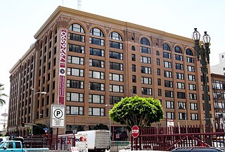
The historic Pacific Electric Building, opened in 1905 in the core of Los Angeles as the main train station for the Pacific Electric Railway, as well as the company's headquarters; Main Street Station served passengers boarding trains for the south and east of Southern California. The building was designed by architect Thornton Fitzhugh. Though not the tallest in Los Angeles, its ten floors enclosed the greatest number of square feet in any building west of Chicago for many decades. Above the train station, covering the lower floors, were five floors of offices; and in the top three was the Jonathan Club, one of the city's leading businessmen's clubs introduced by magnates from the Northeast. After the “Great Merger” of Pacific Electric into Southern Pacific Railroad in 1911, the PE Building became the home of Southern Pacific in Los Angeles. In 1925, a second electric rail hub, the Subway Terminal, was opened near Pershing Square to serve the north and west.

<span class="mw-page-title-main">Pasadena Short Line</span> Pacific Electric streetcar line (1894–1951)

The Pasadena Short Line was a passenger railway line of the Pacific Electric Railway. It ran between Downtown Los Angeles and Downtown Pasadena, California, through Eastside Los Angeles along the foot of the eastern San Rafael Hills to the western San Gabriel Valley. It was in service under the company between 1902 until 1951, though it had operated under different companies back to its beginnings as a horsecar line. The route, designated by the company as line 2, was the key component of the company's Northern Subdivision.

<span class="mw-page-title-main">Balboa Line</span> Pacific Electric streetcar line (1904-1950)

The Balboa Line was the southernmost route of the Pacific Electric Railway. It ran between Downtown Los Angeles and the Balboa Peninsula in Orange County by way of North Long Beach, though the route was later cut back to the Newport Dock. It was designated as route 17.

<span class="mw-page-title-main">Owensmouth Line</span> Former Pacific Electric interurban service

The Owensmouth Line was a Pacific Electric interurban service that connected the San Fernando Valley to Downtown Los Angeles. The route was largely developed as the result of real estate speculation.

<span class="mw-page-title-main">Whittier Line</span> Pacific Electric interurban route in California

The Whittier Line was a Pacific Electric interurban line which traveled between Los Angeles and Whittier via Huntington Park, Rivera, and Los Nietos. A branch of the company's original Long Beach Line, operations along the line began in 1903. Due to its indirect route, passenger operations were eventually replaced by bus service on Whittier Boulevard after 1938. Tracks were largely retained for use by freight trains, eventually becoming the Union Pacific La Habra Subdivision. A short segment of the route is expected to be reactivated for passenger service as part of the Southeast Gateway Line.

<span class="mw-page-title-main">West Santa Ana Branch</span> Rail line in California, US

The West Santa Ana Branch is a rail right-of-way formerly used by the Pacific Electric's (PE) Santa Ana route in Los Angeles County and Orange County in Southern California. The Los Angeles County Metropolitan Transportation Authority (Metro) owns the segment of the right-of-way in Los Angeles County, and the Orange County Transportation Authority (OCTA) owns the segment in Orange County.

<span class="mw-page-title-main">La Habra–Fullerton–Yorba Linda Line</span> Pacific Electric interurban route in California

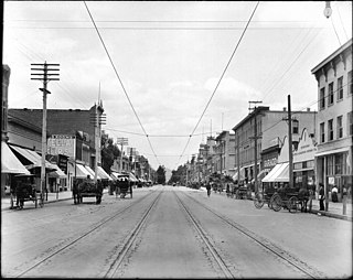
La Habra–Fullerton–Yorba Linda Line was a Pacific Electric interurban line which traveled between Los Angeles and Yorba Linda.

<span class="mw-page-title-main">Long Beach Line</span> Pacific Electric interurban route in California

The Long Beach Line was a major interurban railway operated by the Pacific Electric Railway between Los Angeles and Long Beach, California via Florence, Watts, and Compton. Service began in 1902 and lasted until 1961, the last line of the system to be replaced by buses.

<span class="mw-page-title-main">Pacific Electric Sub-Station No. 14</span> United States historic place

The Pacific Electric Sub-Station No. 14 is a former traction substation in Santa Ana, California. It was built by the Pacific Electric Railway to provide electricity to run the railway's streetcars in central Orange County, California. The building was added to the National Register of Historic Places in 1983.

<span class="mw-page-title-main">Watts Line</span>

The Watts Line was a local line of the Pacific Electric Railway that operated between the Pacific Electric Building in Downtown Los Angeles and the Watts Station at 103rd Street in Watts. It was the primary local service for the Southern District, which also included the Long Beach, San Pedro, Santa Ana and Whittier interurban lines. The route operated along the Southern Division's Four Tracks route, with the Watts Line using the outer tracks and the Long Beach line and other limited stop lines using the inner tracks.

<span class="mw-page-title-main">Amoco Junction, Los Angeles</span> Railway site, California

Amoco Junction was a junction on the Pacific Electric Railway's Southern District. It was located in Nevin, South Central Los Angeles at 25th Street and Long Beach Boulevard. It was named after a nearby American Olive Company (AmOCo) plant. It was the junction where the Santa Monica Air Line split off from the Watts, Long Beach and other Southern District Lines. It was one of several points at which a tower crossed the quadruple tracks between Downtown Los Angeles and Watts. Despite being a junction, many lines did not stop at Amoco, which was only served by local cars and the Air Line. Service was provided to Amoco Junction between 1904 and 1958. Though it is located along the route of the Los Angeles Metro A Line, it is not a stop or station on it, nor did it become a station on the Expo Line that replaced the Santa Monica Air Line.

The OC Streetcar is a modern streetcar line currently under construction in Orange County, California, running through the cities of Santa Ana and Garden Grove. The electric-powered streetcar will be operated by the Orange County Transportation Authority (OCTA), and will serve ten stops in each direction along its 4.15-mile (6.68 km) route.

Bellflower station is a planned light rail station in the Los Angeles Metro Rail system. It is part of the Southeast Gateway Line project. The segment of the corridor is expected to begin operations in 2035.

<span class="mw-page-title-main">Western and Franklin Avenue Line</span> Former streetcar route in Los Angeles, California

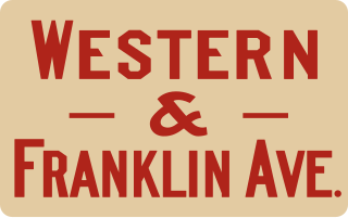
The Western and Franklin Avenue Line was a Pacific Electric streetcar line which traveled from Los Angeles to Hollywood. It operated from 11th and Hill Streets via Hill, Sunset, Santa Monica Boulevard, Western Avenue, Franklin Avenue, Argyle Avenue, Yucca Street, and Vine Street to end at Hollywood and Vine Boulevards. It operated from 1908 to 1940. The Brush Canyon Line branched from this line at Bronson.

<span class="mw-page-title-main">Lynwood Pacific Electric Railway Depot</span>

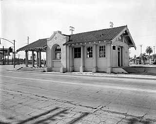
The Lynwood Pacific Electric Railway Depot is a former railway station of the Pacific Electric Railway, located in Lynwood, California. Originally in service on the Santa Ana Line, the station building was moved after the construction of the Century Freeway and now resides in downtown Lynwood.

<span class="mw-page-title-main">Santa Ana–Huntington Beach Line</span> Pacific Electric streetcar line (1907–1922)

The Santa Ana–Huntington Beach Line is a former Pacific Electric interurban railway line in Orange County, California. Unlike most of the company's services, trains did not travel to Downtown Los Angeles and instead provided a suburban service between Santa Ana and Huntington Beach, for a time running as far as Balboa.

The Santa Ana–Orange Line is a former Pacific Electric interurban railway line in Orange County, California. Unlike most of the company's services, trains did not travel to Downtown Los Angeles and instead provided a suburban service between Santa Ana and Orange.

<span class="mw-page-title-main">San Bernardino–Riverside Line</span> Railway line in California

The San Bernardino–Riverside is a former Pacific Electric (PE) interurban railway line in the Inland Empire. Unlike most of the company's services, trains did not travel to Downtown Los Angeles and instead provided a suburban service between San Bernardino and Riverside.

<span class="mw-page-title-main">Venice–Inglewood Line</span> Historic rail route in California

The Venice–Inglewood Line is a former railway line in Los Angeles County, California. The route was established by the Atchison, Topeka and Santa Fe Railway in 1887 before eventually being absorbed into the Pacific Electric interurban railway system. Service under electrification was very sparse, providing a suburban route between Venice and Inglewood.

References

  1. 1 2 "1981 Inventory of Pacific Electric Routes" (PDF). Caltrans. February 1982. Retrieved June 3, 2020.
  2. "First electric car runs to Santa Ana". The Los Angeles Times . November 6, 1905. p. 3. Retrieved December 10, 2022 via Newspapers.com. Lock-green.svg
  3. Crise, Steve; Patris, Michael A. (2011). Pacific Electric Railway. Arcadia Publishing. p. 47. ISBN   9780738575865.
  4. 1 2 3 4 5 6 Veysey, Laurence R. (June 1958). A History Of The Rail Passenger Service Operated By The Pacific Electric Railway Company Since 1911 And By Its Successors Since 1953 (PDF). LACMTA (Report). Los Angeles, California: Interurbans. pp. 75–77. ASIN   B0007F8D84. OCLC   6565577.
  5. Brightwell, Eric (August 27, 2014). "Reimagining Garden Grove with Orange County's First Open Streets Event". KCET. Retrieved July 28, 2021.
  6. "Buses Replace 2 PE Lines' Trolleys". Los Angeles Evening Citizen News. Los Angeles Evening Citizen News. July 3, 1950. p. 9. Retrieved February 4, 2022 via Newspapers.com. Lock-green.svg
  7. Nelson, Laura J. (May 24, 2018). "Metro narrows the options for a light-rail line from downtown L.A. to Artesia". Los Angeles Times . Retrieved September 8, 2021.
  8. 1 2 3 "Santa Ana Line". The Electric Railway Historical Association of Southern California. Retrieved September 6, 2020.
Template:Attached KML/Santa Ana Line
KML is not from Wikidata