East Lake, Pinellas County, Florida

Last updated

East Lake, Florida
Lake Tarpon View.jpg
Lake Tarpon from John Chestnut Park in East Lake.
Pinellas County Florida Incorporated and Unincorporated areas East Lake Highlighted.svg
Location in Pinellas County and the state of Florida
Coordinates: 28°6′0″N82°41′50″W / 28.10000°N 82.69722°W / 28.10000; -82.69722
CountryUnited States
State Florida
Counties Pinellas
Area
  Total31.6 sq mi (81.8 km2)
  Land28.9 sq mi (74.9 km2)
  Water2.7 sq mi (7.0 km2)
Population
 (2020)
  Total32,344
  Density1,000/sq mi (400/km2)

East Lake is a census-designated place (CDP) in Pinellas County, Florida, United States. It was one of the last areas in the densely populated county to develop and often confused with East Lake in neighboring Hillsborough County. The population was 32,344 at the 2020 census.

Contents

Description

East Lake is a census area that consists of the separate sub-communities of East Lake Woodlands, Lansbrook, Ridgemoor, Woodfield, Boot Ranch, and Tarpon Woods. Its boundaries include Pasco County to the north, Hillsborough County to the east, the city of Oldsmar to the south, and Palm Harbor and the city of Tarpon Springs to the west. It is represented in the U.S. House of representatives by Gus Bilirakis.

The area is popular with families due to the quality of East Lake High School which has managed to rate equivalently with Palm Harbor's University High School (both A+ rated), despite not having the attraction of an International Baccalaureate program like Palm Harbor University High. Also of benefit are the top-flight youth recreational programs offered by East Lake/City of Oldsmar.

Geography

East Lake is located at 28°6′0″N82°41′50″W / 28.10000°N 82.69722°W / 28.10000; -82.69722 (28.099957, -82.697220). [1] The unincorporated community is located just north of Oldsmar and east of Palm Harbor and Tarpon Springs.

According to the United States Census Bureau, the CDP has a total area of 31.6 square miles (81.8 km2), of which 28.9 square miles (74.9 km2) is land and 2.7 square miles (7.0 km2) (8.50%) is water. [2]

The closest beach is Honeymoon Island State Park. The closest county park is John Chesnut Sr. County Park, which covers approximately 255 acres (1.03 km2) off the east shore Lake Tarpon. [3]

Demographics

Historical population
CensusPop.Note
2000 29,394
2010 30,9625.3%
2020 32,3444.5%
U.S. Decennial Census [4]

2010 and 2020 census

East Lake racial composition
(Hispanics excluded from racial categories)
(NH = Non-Hispanic)
RacePop 2010 [5] Pop 2020 [6] % 2010% 2020
White (NH)27,10726,39887.55%81.62%
Black or African American (NH)4556191.47%1.91%
Native American or Alaska Native (NH)37450.12%0.14%
Asian (NH)1,0581,2953.42%4.00%
Pacific Islander or Native Hawaiian (NH)6120.02%0.04%
Some other race (NH)301090.10%0.34%
Two or more races/Multiracial (NH)4271,1821.38%3.65%
Hispanic or Latino (any race)1,8422,6845.95%8.30%
Total30,96232,344

As of the 2020 United States census, there were 32,344 people, 13,495 households, and 9,158 families residing in the CDP. [7]

As of the 2010 United States census, there were 30,962 people, 13,195 households, and 8,654 families residing in the CDP. [8]

2000 census

As of the census [9] of 2000, there were 29,394 people, 11,854 households, and 8,914 families residing in the CDP. The population density was 381.1/km2 (987.0/mi2). There were 13,339 housing units at an average density of 172.9/km2 (447.9/mi2). The racial makeup of the CDP was 94.87% White, 1.11% African American, 0.14% Native American, 2.31% Asian, 0.01% Pacific Islander, 0.58% from other races, and 0.98% from two or more races. Hispanic or Latino of any race were 3.72% of the population.

As of 2000, there were 11,854 households, out of which 31.8% had children under the age of 18 living with them, 67.1% were married couples living together, 6.2% had a female householder with no husband present, and 24.8% were non-families. 20.8% of all households were made up of individuals, and 8.2% had someone living alone who was 65 years of age or older. The average household size was 2.48 and the average family size was 2.88.

In 2000, in the CDP, the population was spread out, with 23.8% under the age of 18, 4.3% from 18 to 24, 26.2% from 25 to 44, 27.8% from 45 to 64, and 17.9% who were 65 years of age or older. The median age was 43 years. For every 100 females there were 94.7 males. For every 100 females age 18 and over, there were 90.4 males.

In 2000, the median income for a household in the CDP was $67,546, and the median income for a family was $79,029. Males had a median income of $61,625 versus $32,289 for females. The per capita income for the CDP was $36,206. About 3.1% of families and 3.9% of the population were below the poverty line, including 4.5% of those under age 18 and 3.9% of those age 65 or over.

Schools

East Lake High School has managed to rate equivalently with Palm Harbor's University High School (both A+ rated), despite not having the attraction of an International Baccalaureate program like Palm Harbor University High. Additionally, East Lake is home to an engineering magnet middle school (East Lake Middle School) and two large elementary schools (Brooker Creek Elementary and Cypress Woods Elementary). [10] [11] [12]

Also of note are the top-flight youth recreational programs offered by East Lake/City of Oldsmar.

Public Library

The East Lake Community Library is the public library that services the East Lake and greater Pinellas County area. It is a member of the Pinellas Public Library Cooperative. The library itself is a result of community initiative which resulted in the ELCL opening a physical building November 1, 1999. [13]

In 2013 the ELCL "became an independent library with its own taxing district, thereby providing a new revenue stream for operational expenses and enhancements to the building. This also resulted in an increase in hours, staffing, programs, services, and collections." [14]

The library’s outdoor space is designated as a Florida Butterfly Garden. [15] As of January 2015, the library has established a special collection area for local, self-published authors to submit their works for circulation and display. [16]

In 2016, then Governor Rick Scott passed the Florida State Budget granting the ELCL a $1,000,000 in funding for expansion of the library. [17] On November 20, 2017, the library broke ground on the phase 1 of the expansion which aimed to expand the library by 2,600 square feet. [18]

Related Research Articles

<span class="mw-page-title-main">Pasco County, Florida</span> County in Florida, United States

Pasco County is located on the west central coast of the U.S. state of Florida. According to the 2020 census, the population was 561,691. Its county seat is Dade City, and its largest city is Zephyrhills. The county is named after Samuel Pasco.

<span class="mw-page-title-main">Pinellas County, Florida</span> County in Florida, United States

Pinellas County is a county located on the west central coast of the U.S. state of Florida. As of the 2020 census, the population was 959,107, which makes it the seventh-most populous county in the state. It is also the most densely populated county in Florida, with 3,491 residents per square mile. The county is part of the Tampa–St. Petersburg–Clearwater Metropolitan Statistical Area. Clearwater is the county seat. St. Petersburg is the largest city in the county, as well as the largest city in Florida that is not a county seat.

<span class="mw-page-title-main">East Lake-Orient Park, Florida</span> Census-designated place in Florida, United States

East Lake-Orient Park is an unincorporated census-designated place in Hillsborough County, Florida, United States. The population was 22,753 at the 2010 census, up from 5,703 at the 2000 census following an expansion of its borders. The area is the home of the Florida State Fairgrounds, which hosts the Florida State Fair in mid-February of each year. It was previously home to East Lake Square Mall. The ZIP code for East Lake-Orient Park is 33610 and 33619.

<span class="mw-page-title-main">Fish Hawk, Florida</span> Census-designated place in Florida, United States

Fish Hawk is an unincorporated area and census-designated place (CDP) in Hillsborough County, Florida, United States. It is a suburb of Tampa, and includes a portion of the community of Lithia. As of the 2020 census, the CDP had a population of 24,625. The place name is derived from Little Fishhawk Creek, a tributary of the Alafia River that joins the Alafia just west of Lithia Springs.

<span class="mw-page-title-main">Keystone, Florida</span> Census-designated place in Florida, United States

Keystone is an unincorporated census-designated place in Hillsborough County, Florida, United States. The Keystone area was first settled in the middle 1800s by the W.M. Mobley Family who migrated from Savannah, Georgia. The region has evolved from citrus and farming into a rural retreat of many lake homes and ranches. The population was 24,039 at the 2010 census, up from 14,627 at the 2000 census. The ZIP Codes encompassing the CDP area are 33556 and 33558.

<span class="mw-page-title-main">Town 'n' Country, Florida</span> Census-designated place in Florida, United States

Town 'n' Country is a census-designated place (CDP) in Hillsborough County, Florida, United States. The population was 85,951 at the 2020 census.

<span class="mw-page-title-main">Valrico, Florida</span> Census-designated place in Florida, United States

Valrico is a census-designated place (CDP) in Hillsborough County, Florida, United States. As of 2020 the population was 37,895.

<span class="mw-page-title-main">Westchase, Florida</span> Census-designated place in Florida, United States

Westchase is a census-designated place (CDP) in Hillsborough County, Florida, United States. The population was 21,747 at the 2010 census, up from 11,116 at the 2000 census. The census area encompasses most of the 33626 ZIP code area.

<span class="mw-page-title-main">Palm City, Florida</span> Census-designated place in Florida, United States

Palm City is an unincorporated area and census-designated place (CDP) in Martin County, Florida, United States. The population was 25,883 at the 2020 census. It is part of the Port St. Lucie Metropolitan Statistical Area.

<span class="mw-page-title-main">Kendale Lakes, Florida</span> Census-designated place in Florida

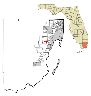
Kendale Lakes is a census-designated place (CDP) and a suburb of Miami in Miami-Dade County, Florida, United States. It is located in the Miami metropolitan area of South Florida. The population was 55,646 at the 2020 census.

<span class="mw-page-title-main">Olympia Heights, Florida</span> Census-designated place in Florida

Olympia Heights is a census-designated place in Miami-Dade County, Florida, United States. It is located in the Miami metropolitan area of South Florida. The population was 12,873 at the 2020 census.

<span class="mw-page-title-main">Palm Springs North, Florida</span> Census-designated place in Florida

Palm Springs North is an unincorporated community and census-designated place (CDP) in Miami-Dade County, Florida, United States. It is part of the Miami metropolitan area of South Florida. The population was 5,030 at the 2020 census.

<span class="mw-page-title-main">Westwood Lakes, Florida</span> Census-designated place in Florida

Westwood Lakes is a census-designated place and unincorporated community of Miami-Dade County, Florida, United States. It is part of the Miami metropolitan area of South Florida. The population was 11,373 at the 2020 census.

<span class="mw-page-title-main">Canal Point, Florida</span> CDP in Florida, United States

Canal Point is a census-designated place (CDP) and unincorporated community in Palm Beach County, Florida, United States. It is part of the Miami metropolitan area of South Florida despite its local culture and location being way more similar to the Florida Heartland. Canal Point has a population of 344 people counted in the 2020 US census.

<span class="mw-page-title-main">Lake Harbor, Florida</span> CDP in Florida, United States

Lake Harbor is a census-designated place (CDP) in Palm Beach County, Florida, United States. It is part of the Miami metropolitan area of South Florida despite being physically and culturally closer to the Florida Heartland. The population was 49 at the 2020 US census.

<span class="mw-page-title-main">Holiday, Florida</span> CDP in Florida, United States

Holiday is a census-designated place (CDP) in Pasco County, Florida, United States. It is a suburb of the Tampa-St. Petersburg-Clearwater, Florida Metropolitan Statistical Area. The population was 24,939 as of the 2020 census.

<span class="mw-page-title-main">Oldsmar, Florida</span> City in Florida, United States

Oldsmar is a city in Pinellas County, Florida, United States. As of the 2020 census, the city had a population of 14,898. The Oldsmar name dates to April 12, 1916, when automobile pioneer Ransom E. Olds purchased 37,541 acres (151.92 km2) of land north of Tampa Bay to establish a planned community.

<span class="mw-page-title-main">Palm Harbor, Florida</span> Census-designated place in Florida, United States

Palm Harbor is a census-designated place (CDP) and unincorporated community in Pinellas County, Florida, United States. As of the 2020 census, the CDP had a population of 61,366.

<span class="mw-page-title-main">Carrollwood (CDP), Florida</span> Census-designated place in Florida, United States

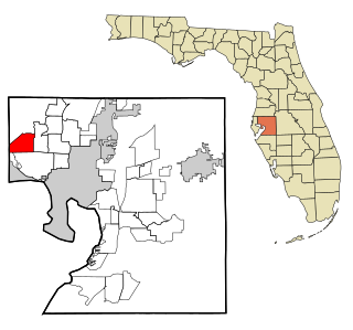
Carrollwood is a census-designated place (CDP) in northwestern Hillsborough County, Florida, United States. The census area includes the unincorporated communities of Carrollwood and Carrollwood Village. For the 2000 census the area was enumerated under the name "Greater Carrollwood". A similar area was listed as "Lake Carroll" in 1970 and 1980; for the 1990 census it was split into the smaller Carrollwood and Carrollwood Village CDPs. The population was 34,352 at the 2020 census.

<span class="mw-page-title-main">Alafaya, Florida</span> Census-designated place in Florida, United States

Alafaya is a census-designated place and unincorporated area in Orange County, Florida, United States. The population was 92,452 at the 2020 US census. It is part of the Orlando–Kissimmee–Sanford, Florida Metropolitan Statistical Area. It is most known for being near the University of Central Florida, Avalon Park and Waterford Lakes.

References

  1. "US Gazetteer files: 2010, 2000, and 1990". United States Census Bureau. February 12, 2011. Retrieved April 23, 2011.
  2. "Geographic Identifiers: 2010 Demographic Profile Data (G001): East Lake CDP, Florida". United States Census Bureau . Retrieved May 15, 2012.
  3. "John Chesnut Sr. Park". Pinellas County. Retrieved April 17, 2024.
  4. "Decennial Census of Population and Housing by Decades". US Census Bureau . Retrieved November 7, 2023.
  5. "P2 HISPANIC OR LATINO, AND NOT HISPANIC OR LATINO BY RACE - 2010: DEC Redistricting Data (PL 94-171) - East Lake CDP, Florida". United States Census Bureau .
  6. "P2 HISPANIC OR LATINO, AND NOT HISPANIC OR LATINO BY RACE - 2020: DEC Redistricting Data (PL 94-171) - East Lake CDP, Florida". United States Census Bureau .
  7. "S1101 HOUSEHOLDS AND FAMILIES - 2020: East Lake CDP, Florida". United States Census Bureau .
  8. "S1101 HOUSEHOLDS AND FAMILIES - 2010: East Lake CDP, Florida". United States Census Bureau .
  9. "U.S. Census website". United States Census Bureau . Retrieved January 31, 2008.
  10. "East Lake Middle School (ms) / Homepage". www.pcsb.org. Retrieved April 17, 2024.
  11. "Brooker Creek Elementary (es) / Homepage". www.pcsb.org. Retrieved April 17, 2024.
  12. "Cypress Woods Elementary (es) / Homepage". www.pcsb.org. Retrieved April 17, 2024.
  13. "Our History".
  14. "Our History".
  15. "East Lake optimistic about state funding".
  16. "Archived copy". Archived from the original on April 1, 2015. Retrieved April 19, 2015.{{cite web}}: CS1 maint: archived copy as title (link)
  17. "One million dollars for East Lake Community Library".
  18. "East Lake's Library to break ground on expansion".