Pretty Bayou is a census-designated place (CDP) in Bay County, Florida, United States. The population was 3,206 at the 2010 census. It is part of the Panama City–Lynn Haven–Panama City Beach Metropolitan Statistical Area. In 2018, Hurricane Michael caused significant damage to the city.

Cheval is a census-designated place in Hillsborough County, Florida, United States. The population was 10,702 at the 2010 census, up from 7,602 at the 2000 census.

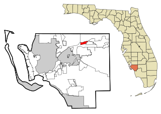
Keystone is an unincorporated census-designated place in Hillsborough County, Florida, United States. The Keystone area was first settled in the middle 1800s by the W.M. Mobley Family who migrated from Savannah, Georgia. The region has evolved from citrus and farming into a rural retreat of many lake homes and ranches. The population was 24,039 at the 2010 census, up from 14,627 at the 2000 census. The ZIP Codes encompassing the CDP area are 33556 and 33558.

Mango is a census-designated place (CDP) in Hillsborough County, Florida, United States. The population was 11,313 at the 2010 census, up from 8,842 at the 2000 census.

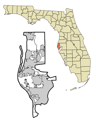
Town 'n' Country is a census-designated place (CDP) in Hillsborough County, Florida, United States. The population was 85,951 at the 2020 census.
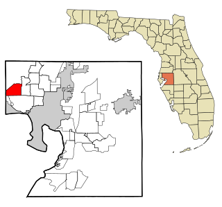
Westchase is a census-designated place (CDP) in Hillsborough County, Florida, United States. The population was 21,747 at the 2010 census, up from 11,116 at the 2000 census. The census area encompasses most of the 33626 ZIP code area.
Fort Myers Shores is an unincorporated community and census-designated place (CDP) in Lee County, Florida, United States. The population was 5,774 at the 2020 census. It is part of the Cape Coral-Fort Myers, Florida Metropolitan Statistical Area.

Andrews is a census-designated place (CDP) in Levy County, Florida, United States. The population was 798 at the 2010 census.

Manatee Road is a census-designated place (CDP) in Levy County, Florida, United States. The population was 2,244 at the 2010 census. At the 2000 census, the CDP was misspelled as "Manattee Road".

West Bradenton is an unincorporated area and census-designated place (CDP) in Manatee County, Florida, United States. The population was 4,247 at the 2020 census. It is part of the Bradenton–Sarasota–Venice Metropolitan Statistical Area.
Belleair Shore is a town in Pinellas County, Florida, United States. It was established in 1955. As of the 2010 census, it had a population of 109.

East Lake is a census-designated place (CDP) in Pinellas County, Florida, United States. The population was 30,962 at the 2010 census. It was one of the last areas in the densely populated county to develop. It is often confused with East Lake in neighboring Hillsborough County.

Feather Sound is a census-designated place (CDP) in Pinellas County, Florida, United States. The population was 3,420 at the 2010 census. It includes the St. Petersburg-Clearwater International Airport.

Palm Harbor is a census-designated place and unincorporated community in Pinellas County, Florida, United States. As of the 2016 American Community Survey, the CDP had a population of 60,236.

South Highpoint is a census-designated place (CDP) in Pinellas County, Florida, United States. The population was 5,195 at the 2010 census.

West and East Lealman, more commonly known collectively as Lealman, was a census-designated place (CDP) in Pinellas County, Florida, United States. The population was 21,753 at the 2000 census. For the 2010 census, the area was split into two separate CDPs, Lealman and West Lealman.
Lealman, known as East Lealman until 2010, is a census-designated place (CDP) in Pinellas County, Florida, United States. The population was 19,879 at the 2010 census. Prior to 2010, Lealman was part of a larger CDP named West and East Lealman.

Bardmoor is a census-designated place (CDP) in Pinellas County, Florida, United States. The population was 9,732 at the 2010 census.

Bear Creek is an unincorporated community and census-designated place (CDP) in Pinellas County, Florida, United States. The population was 1,948 at the 2010 census.
Greenbriar is an unincorporated community and census-designated place (CDP) in Pinellas County, Florida, United States. The population was 2,502 at the 2010 census.

