
Bucks County is a county located in the Commonwealth of Pennsylvania. As of the 2020 census, the population was 646,538; it is the fourth-most populous county in Pennsylvania. The county seat is Doylestown. The county is named after the English county of Buckinghamshire or more precisely, its abbreviation.

Bensalem Township is a township in Bucks County, Pennsylvania. It borders the northeast section of Philadelphia. The township is composed of many communities, including Andalusia, Bensalem, Bridgewater, Cornwells Heights, Eddington, Flushing, Oakford, Siles, Trappe, and Trevose. Bensalem Township has no incorporated municipalities within its boundaries.

Bristol Township is a township in Bucks County, Pennsylvania. The population was 54,582 at the 2010 census, making it the 13th largest municipality in the state. Bristol Township, along with Bristol Borough, is a cultural hub for Lower Bucks County, hosting celebrations of African and Latino heritage. Parts of the township consist of the neighborhoods of Fairless Hills and Levittown, Pennsylvania.

Churchville is a census-designated place (CDP) in Northampton Township, Bucks County, Pennsylvania, United States. The population was 4,128 at the 2010 census.
Cornwells Heights-Eddington was a census-designated place (CDP) in Bucks County, Pennsylvania, United States. The population was 3,406 at the 2000 census. For the 2010 census, the area was split into two CDPs, Cornwells Heights and Eddington, that are adjacent unincorporated communities within Bensalem Township. Cornwells Heights is located a bit southwest of Eddington. Both communities use the Bensalem ZIP code, 19020.
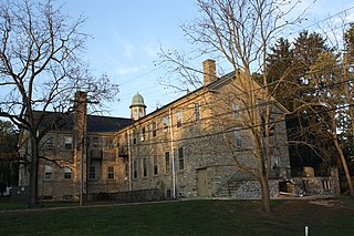
Doylestown Township is a township in Bucks County, Pennsylvania. The population was 17,565 at the 2010 census. Adjacent to the county seat, many county offices and the county correctional facility are located in this township. Doylestown Central Park is a park in the township.

Lower Southampton Township is a township in Bucks County, Pennsylvania, United States. The population was 20,599 at the 2020 census.

Newtown is a borough in Bucks County, Pennsylvania, United States. The population was 2,248 at the 2010 census. It is located just west of the Trenton, New Jersey metropolitan area, and is part of the larger Philadelphia metropolitan area. It is entirely surrounded by Newtown Township, from which it separated in 1838. State Street is the main commercial thoroughfare with wide sidewalks, shops, taverns, and restaurants.

Northampton Township is a township in Bucks County, Pennsylvania. It is located roughly 12 miles northeast of Philadelphia. The population was 39,726 at the 2010 census.

Upper Southampton Township is a township in Bucks County, Pennsylvania, United States. The population was 15,152 at the 2010 census.

Warminster Township is located in Bucks County, Pennsylvania. It was formally established in 1711. It is 13.7 miles north of Philadelphia and had a population of 32,682 according to the 2010 U.S. census.

Warminster Heights is a census-designated place and part of Warminster Township in Bucks County, Pennsylvania. It is located near the east border of Hatboro in Montgomery County, Pennsylvania. The population was 4,124 at the 2010 census.

Warrington Township is a township in Bucks County, Pennsylvania, United States. Warrington Township is a northern suburb of Philadelphia. The population was 23,418 at the 2010 census.

Horsham is a home rule municipality in Montgomery County, Pennsylvania, United States. The population was 14,842 at the 2010 census. Horsham is located entirely within Horsham Township, and it is home to the Horsham Air Guard Station at the former site of Naval Air Station Joint Reserve Base Willow Grove.

Montgomery Township is a township in Montgomery County, Pennsylvania, United States. It is the location of the Montgomery Mall, a regional shopping mall serving the Route 309 corridor of the Philadelphia suburbs. Much of Montgomery Township's development is suburban in character, with newer tract houses and strip shopping centers. Homes in Montgomery Township have North Wales and Lansdale addresses, but businesses that are located within the township boundaries are given the Montgomeryville ZIP code. The township is in the North Penn School District and is part of the North Penn Valley region that is centered around the borough of Lansdale.

Upper Moreland Township is a township in Montgomery County, Pennsylvania, United States. The population was 24,015 at the 2010 census. Upper Moreland Township is primarily a residential community with distinctive neighborhoods that are complemented by several thriving business, industrial, and commercial districts.

Cornwells Heights is a census-designated place located in Bensalem Township in Bucks County, Pennsylvania. The community was formerly part of Cornwells Heights-Eddington, but was split into two separate CDP's. As of the 2010 census, the population was 1,391. The Cornwells Heights station is located in the community and serves SEPTA Regional Rail's Trenton Line and Amtrak's Keystone Service and Northeast Regional services along the Northeast Corridor. The train station also has a park-and-ride with access from Interstate 95.

Pennsylvania Route 132 (PA 132) is a state highway in southeast Pennsylvania. The route, which is signed east-west, runs northwest to southeast through Bucks County in suburban Philadelphia from PA 611 in Warrington southeast to Interstate 95 (I-95) in Bensalem. PA 132 is a commercial route lined with shopping centers throughout much of its 15-mile (24 km) length. It is named Street Road and is five lanes wide for much of its length. The route was also designated as the Armed Forces and Veterans Memorial Highway in 2005. From west to east, PA 132 crosses PA 263 and PA 332 in Warminster; PA 232 in Southampton; PA 532 in Feasterville; and U.S. Route 1 (US 1), the Pennsylvania Turnpike (I-276), PA 513, and US 13 in Bensalem. Street Road was included in William Penn's survey plans and completed by 1737. The road was paved by 1911 and received the PA 132 designation between US 611 and US 13 by 1927. The route was widened into a multi-lane highway and extended east from US 13 to I-95 by 1970. An interchange with the eastbound direction of the Pennsylvania Turnpike opened in 2010.

Trevose, also known as the TVO(tee,vee,oh), is a census-designated place within Lower Southampton Township, while the entire community of Trevose within and beyond the CDP is in both Bensalem and Lower Southampton Townships in Bucks County, Pennsylvania, United States, which is north of and borders northeastern Philadelphia. Trevose was formerly part of Feasterville-Trevose, but was split into two separate CDPs for the 2010 census. U.S. 1 runs through the town as well as the Pennsylvania Turnpike, but Trevose's main road is Brownsville Road, which is the dividing line between the two townships. As of the 2010 census, Trevose had a population of 3,550.
Neshaminy Falls is an unincorporated community in Bensalem Township in Bucks County, Pennsylvania, United States. Neshaminy Falls is located in the northwestern part of the township southwest of Bristol Road. It is served by the Neshaminy Falls station on SEPTA's West Trenton Line.


