
Bucks County is a county in the Commonwealth of Pennsylvania. As of the 2020 census, the population was 646,538, making it the fourth-most populous county in Pennsylvania. Its county seat is Doylestown. The county is named after the English county of Buckinghamshire.

Bensalem Township is a township in Bucks County, Pennsylvania, United States. The township borders the northeastern section of Philadelphia and includes the communities of Andalusia, Bensalem, Bridgewater, Cornwells Heights, Eddington, Flushing, Oakford, Siles, Trappe, and Trevose. Bensalem Township has no other incorporated municipalities within its boundaries.

Bristol is a borough in Bucks County, Pennsylvania, United States. It is located 23 miles (37 km) northeast of Center City Philadelphia, opposite Burlington, New Jersey on the Delaware River. It antedates Philadelphia,being settled in 1681 and first incorporated in 1720. After 1834, it became very important to the development of the American Industrial Revolution as the terminus city of the Delaware Canal, providing greater Philadelphia with the day's high tech anthracite fuels from the Lehigh Canal via Easton. The canal and a short trip on the Delaware also gave the town access to the mineral resources available in Connecticut, New Jersey and New York via each of the Morris Canal, the Delaware and Hudson Canal, and the Delaware and Raritan Canal, and connected the community to those markets and trade from New York City.

Bristol Township is a township in Bucks County, Pennsylvania, United States. The population was 54,582 at the 2010 census, making it the 13th largest municipality in the state. Bristol Township, along with Bristol Borough, is a cultural hub for Lower Bucks County, hosting celebrations of African and Latino heritage. Parts of the township consist of the neighborhoods of Fairless Hills and Levittown. It is located within the Delaware Valley.

Hulmeville is a borough in Bucks County, Pennsylvania. The population was 1,003 at the 2010 census.

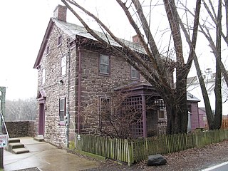
Langhorne Borough is a borough in Bucks County, Pennsylvania. The population was 1,622 at the time of the 2010 census.

Middletown Township is a township in Bucks County, Pennsylvania, United States. The population was 46,040 at the 2020 census. Many sections of Levittown are located in the southern end of the township. The municipality surrounds the boroughs of Langhorne, Langhorne Manor, Penndel and Hulmeville; much of the township beyond Levittown uses Langhorne as a mailing address. It is located within the Delaware Valley.

Penndel is a borough in Bucks County, Pennsylvania, United States. The population was 2,328 at the 2010 census.

Warminster Township is located in Bucks County, Pennsylvania, United States. It was formally established in 1711. The township is 13.7 miles north of Philadelphia and had a population of 33,603 according to the 2020 U.S. census.

Warrington Township is a township in Bucks County, Pennsylvania, United States. Warrington Township is a northern suburb of Philadelphia. The population was 25,639 at the 2020 census.

Horsham is a census place in Horsham Township, Montgomery County, Pennsylvania, United States. The population was 15,193 at the 2020 census. It is home to the Horsham Air Guard Station at the former site of Naval Air Station Joint Reserve Base Willow Grove.
Bristol Beach State Park is a 242-acre (0.98 km2) undeveloped state park located on the Hudson River in the town of Saugerties in Ulster County, New York. The park was initially formed in 1967, and is managed by the Palisades Interstate Park Commission.

Pennsylvania Route 132 (PA 132) is a state highway in southeast Pennsylvania. The route, which is signed east–west, runs northwest to southeast through Bucks County in suburban Philadelphia from PA 611 in Warrington southeast to Interstate 95 (I-95) in Bensalem. PA 132 is a commercial route lined with shopping centers throughout much of its 15-mile (24 km) length. It is named Street Road and is five lanes wide for much of its length. The route was also designated as the Armed Forces and Veterans Memorial Highway in 2005. From west to east, PA 132 intersects PA 263 and PA 332 in Warminster; PA 232 in Southampton; PA 532 in Feasterville; and U.S. Route 1 (US 1), the Pennsylvania Turnpike (I-276), PA 513, and US 13 in Bensalem. Street Road was included in William Penn's survey plans and completed by 1737. The road was paved by 1911 and received the PA 132 designation between US 611 and US 13 by 1927. The route was widened into a multilane highway and extended east from US 13 to I-95 by 1970. An interchange with the eastbound direction of the Pennsylvania Turnpike opened in 2010.

Neshaminy School District is a school district headquartered in Middletown Township, Bucks County, Pennsylvania.
Lumberville is a village on the Delaware River in Solebury Township, Bucks County, Pennsylvania, United States. It is located seven miles north of New Hope and is situated along River Road. Its ZIP Code is 18933.
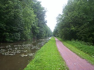
Delaware Canal State Park is a 830-acre (336 ha) Pennsylvania state park in Bucks and Northampton Counties in Pennsylvania. The main attraction of the park is the Delaware Canal which runs parallel to the Delaware River between Easton and Bristol.

Norristown Farm Park is a 690-acre (279 ha) Pennsylvania state park in East Norriton and West Norriton Townships and the Borough of Norristown, Montgomery County, Pennsylvania, in the United States. Located just off of Interstate 276 on West Germantown Pike, it is operated in partnership with the Montgomery County Department of Parks.

Pennsylvania Route 413 is a 31-mile-long (50 km), north–south state highway in Bucks County, Pennsylvania. The route runs from the New Jersey state line on the Burlington–Bristol Bridge over the Delaware River outside Bristol, where the road continues as Route 413 into New Jersey, north to PA 611 in Bedminster Township. The route passes through the lower and central portions of Bucks County, serving Bristol, Levittown, Langhorne, Newtown, and Buckingham. The route intersects U.S. Route 13 and Interstate 95 (I-95) near Bristol, I-295 near Penndel, US 1 in Langhorne Manor, and US 202 in Buckingham.

Pennsylvania Route 213 is a 6.95-mile-long (11.18 km) state highway in Bucks County, Pennsylvania. The route runs from PA 532 in Feasterville, which is located in Lower Southampton Township, north to U.S. Route 1 Business in Middletown Township, near the Oxford Valley Mall. PA 213 is signed as a north-south route but it actually travels east–west through its route, with the northern terminus being well east of the southern terminus but only slightly further north. Along the way, PA 213 passes through the borough of Langhorne and has intermediate junctions with PA 413 in Langhorne and US 1 in Middletown Township. The westernmost part of PA 213 was originally chartered as the Bridgetown and Feasterville Turnpike in 1844. In 1913, the eastern portion of present-day PA 213 became a part of the route for the Lincoln Highway, being bypassed in 1923. PA 213 was designated onto its current alignment in 1928.

James Cawley is an American politician who served as the 32nd lieutenant governor of Pennsylvania from 2011 to 2015. A Republican, he previously served on the Board of Commissioners of Bucks County, Pennsylvania.

