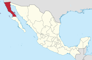
Acapulco de Juárez, commonly called Acapulco, is a city, municipality and major seaport in the state of Guerrero on the Pacific coast of Mexico, 380 kilometres (240 mi) south of Mexico City. Acapulco is located on a deep, semicircular bay and has been a port since the early colonial period of Mexico's history. It is a port of call for shipping and cruise lines running between Panama and San Francisco, California, United States. The city of Acapulco is the largest in the state, far larger than the state capital Chilpancingo. Acapulco is also Mexico's largest beach and balneario resort city.

Mexico City, or the City of Mexico, is the capital of Mexico and the most populous city in North America. It is one of the most important cultural and financial centres in the Americas. It is located in the Valley of Mexico, a large valley in the high plateaus in the center of Mexico, at an altitude of 2,240 meters (7,350 ft). The city has 16 boroughs.
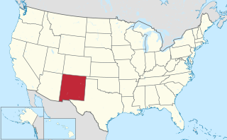
New Mexico is a state in the Southwestern region of the United States of America; its capital and cultural center is Santa Fe, which was founded in 1610 as capital of Nuevo México, while its largest city is Albuquerque with its accompanying metropolitan area. It is one of the Mountain States and shares the Four Corners region with Utah, Colorado, and Arizona; its other neighboring states are Oklahoma to the northeast, Texas to the east-southeast, and the Mexican states of Chihuahua to the south and Sonora to the southwest. With a population around two million, New Mexico is the 36th state by population. With a total area of 121,592 sq mi (314,920 km2), it is the fifth-largest and sixth-least densely populated of the 50 states. Due to their geographic locations, northern and eastern New Mexico exhibit a colder, alpine climate, while western and southern New Mexico exhibit a warmer, arid climate.

Monterrey is the capital and largest city of the northeastern state of Nuevo León, Mexico. The city is anchor to the Monterrey metropolitan area, the second most productive in Mexico with a GDP (PPP) of US$ 123 billion and the third largest with an estimated population of 4,689,601 people as of 2015. Monterrey is also considered as the city with the best quality of life in the country (México) and serves as a commercial center of northern Mexico and is the base of many significant international corporations, its purchasing power parity-adjusted GDP per capita is considerably higher than the rest of the country's at around US$35,500 to the country's US$18,800. It is considered a Beta World City, cosmopolitan and competitive. Rich in history and culture, it is one of the most developed cities in Mexico and is often regarded as its most "Americanized".

Albuquerque, also known locally as Duke City and abbreviated as ABQ, is the most populous city in the U.S. state of New Mexico and the 32nd-most populous city in the United States, with a census-estimated population of 558,545 in 2017. It is the principal city of the Albuquerque metropolitan area, which has 915,927 residents as of July 2018. Albuquerque's Metropolitan statistical area is the 60th-largest in the United States. The Albuquerque MSA population includes the cities of Rio Rancho, Bernalillo, Placitas, Corrales, Los Lunas, Belen, and Bosque Farms, and forms part of the larger Albuquerque–Santa Fe–Las Vegas combined statistical area, with a total population of 1,171,991 in 2016.

Guadalajara is the capital and largest city of the Mexican state of Jalisco, and the seat of the municipality of Guadalajara. The city is in the central region of Jalisco in the Western-Pacific area of Mexico. With a population of 1,460,148 inhabitants, it is Mexico's second most populous municipality. The Guadalajara metropolitan area has a reported population of 5,002,466 inhabitants, making it the second most populous metropolitan area in Mexico, behind Mexico City. The municipality is the second most densely populated in Mexico, the first being Ciudad Nezahualcóyotl in the State of Mexico. It is a strong business and economic center in the Bajío region.

The United Mexican States is a federal republic composed of 31 states and the capital, Mexico City, an autonomous entity.
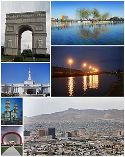
Ciudad Juárez is the most populous city in the Mexican state of Chihuahua. The city is commonly referred to by locals as simply Juárez, and was known as Paso del Norte until 1888. Juárez is the seat of the municipality of Juárez with an estimated population of 1.5 million people. It lies on the Rio Grande river, south of El Paso, Texas, United States. Together with the surrounding areas, the cities form El Paso–Juárez, the second largest binational metropolitan area on the Mexico–U.S. border, with a combined population of over 2.7 million people.
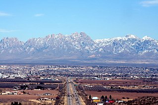
Las Cruces is the seat of Doña Ana County, New Mexico, United States. As of the 2010 census the population was 97,618, and in 2017 the estimated population was 101,712, making it the second largest city in the state, after Albuquerque. Las Cruces is the largest city in both Doña Ana County and southern New Mexico. The Las Cruces metropolitan area had an estimated population of 213,849 in 2017. It is the principal city of a metropolitan statistical area which encompasses all of Doña Ana County and is part of the larger El Paso–Las Cruces combined statistical area.

Michoacán, formally Michoacán de Ocampo, officially the Free and Sovereign State of Michoacán de Ocampo, is one of the 31 states which, with the Federal District, comprise the 32 Federal Entities of Mexico. The State is divided into 113 municipalities and its capital city is Morelia. The city was named after José María Morelos, one of the main heroes of the Mexican War of Independence.

The State of Mexico is one of the 32 federal entities of Mexico. It is the most populous, as well as the most densely populated state. It is divided into 125 municipalities and its capital city is Toluca de Lerdo.

Guanajuato, officially the Free and Sovereign State of Guanajuato, is one of the 31 states which, with Mexico City, are the 32 federal entities of Mexico. It is divided into 46 municipalities and its capital city is Guanajuato. The largest city in the state is León.

Naucalpan, officially Naucalpan de Juárez, is a city and municipality located just northwest of Mexico City in the adjoining State of Mexico.

Mexico, officially the United Mexican States, is a country in the southern portion of North America. It is bordered to the north by the United States; to the south and west by the Pacific Ocean; to the southeast by Guatemala, Belize, and the Caribbean Sea; and to the east by the Gulf of Mexico. Covering almost 2,000,000 square kilometers (770,000 sq mi), the nation is the fourth largest country in the Americas by total area and the 13th largest independent state in the world. With an estimated population of over 129 million people, Mexico is the tenth most populous country and the most populous Spanish-speaking country in the world, while being the second most populous nation in Latin America after Brazil. Mexico is a federation comprising 31 states plus Mexico City (CDMX), which is the capital city and its most populous city. Other metropolises in the country include Guadalajara, Monterrey, Puebla, Toluca, Tijuana, and León.
The Mexican Drug War is an ongoing asymmetric low-intensity conflict between the Mexican government and various drug trafficking syndicates. When the Mexican military began to intervene in 2006, the government's principal goal was to reduce drug-related violence. The Mexican government has asserted that their primary focus is on dismantling the powerful drug cartels, rather than on preventing drug trafficking and demand, which is left to U.S. functionaries.
The flag of Mexico is a vertical tricolor of green, white, and red with the national coat of arms charged in the center of the white stripe. While the meaning of the colors has changed over time, these three colors were adopted by Mexico following independence from Spain during the country's War of Independence, and subsequent First Mexican Empire. The form of the coat of arms was most recently revised in 1968, but the overall design has been used since 1821, when the First National Flag was created.
The Beltrán Leyva Cartel is a Mexican drug cartel and organized crime syndicate, formerly headed by the five Beltrán Leyva brothers: Marcos Arturo, Carlos, Alfredo, Mario Alberto and Héctor. Founded as a branch of the Sinaloa Cartel, the Beltrán Leyva cartel was responsible for transportation and wholesaling of cocaine, heroin and marijuana. It controlled numerous drug trafficking corridors, and engaged in human smuggling, money laundering, extortion, kidnapping, murder and gun-running.

Chihuahua, officially the Estado Libre y Soberano de Chihuahua, is one of the 31 states of Mexico. It is located in Northwestern Mexico and is bordered by the states of Sonora to the west, Sinaloa to the southwest, Durango to the south, and Coahuila to the east. To the north and northeast, it has a long border with the U.S. adjacent to the U.S. states of New Mexico and Texas. Its capital city is Chihuahua City.