San Ysidro Port of Entry

Last updated

San Ysidro Port of Entry
SanYsidroBorderCrossingByPhilKonstantin.jpg
San Ysidro Border Inspection Station in 2011
Location
Country United States
Location
Coordinates 32°32′36″N117°01′47″W / 32.54333°N 117.02972°W / 32.54333; -117.02972
Details
Opened1906
HoursOpen 24 Hours
Exit Port El Chaparral
Statistics
2019 Cars [1] 14,979,363
2019 Individuals [1] 53,296,133
2019 Pedestrians [1] 10,799,398
Website
https://www.bts.gov/browse-statistical-products-and-data/border-crossing-data/border-crossingentry-data

The San Ysidro Port of Entry (aka San Ysidro Land Port of Entry or San Ysidro LPOE) [2] is the largest land border crossing between San Diego and Tijuana, and the fourth-busiest land border crossing in the world (second-busiest excluding the crossings between Mainland China and its two Special Administrative Regions) [3] with 70,000 northbound vehicles and 20,000 northbound pedestrians crossing each day, in addition to southbound traffic. [4] It connects Mexican Federal Highway 1 on the Mexican side with Interstate 5 on the American side. The San Ysidro Port of Entry is one of three ports of entry in the San Diego–Tijuana metropolitan region.

Contents

Gateways

There is a northbound and southbound vehicle crossing, as well as two separate bidirectional pedestrian crossings.

Northbound vehicle crossing

There are currently 34 northbound vehicle lanes to cross from Mexico to the U.S. [5] [6]

Southbound vehicle crossing (El Chaparral)

The southbound lanes of Interstate 5 which take vehicles into Mexico have been moved west of their previous location through the new El Chaparral Point of Entry (Spanish : Puerta México el Chaparral). [7] This relocation and expansion was necessary to provide space for the construction of new administrative and border inspection facilities and to increase the number of northbound vehicle lanes. The El Chaparral gateway also has a vehicle and passenger inspection station at which U.S. officials may conduct inspections of southbound traffic, and provides for more thorough inspection of southbound traffic by Mexican officials. El Chaparral was the name of the Tijuana border crossing prior to the 1983 modifications.

Eastern/main pedestrian crossing

Pedestrians may cross northbound immediately east of the northbound vehicle crossing. As of May 2017 they are temporarily processed in the Milo building while a new facility is built to the west. [8] There are currently 15 pedestrian lanes, [5] and more will be added with the current expansion project.

The eastern (main) southbound pedestrian crossing is east of the northbound crossing, immediately south of the San Ysidro trolley station. Pedestrians pass through the 6.9-million-dollar, three-story Puerta Este México-San Ysidro building, opened in August 2015, containing Mexican passport control and customs [9] which since late 2017 exits to a path leading to Frontera street just southwest of Ferrocarril street. Prior to 2012 the southbound pedestrian crossing was west of the northbound vehicle crossing and exited to a bridge leading to Plaza Viva Tijuana. [10]

PedWest (western pedestrian crossing)

The PedWest pedestrian crossing is located at the east side of the Las Americas outlet mall where Virginia Avenue dead-ends at the border, immediately west of the El Chaparral port of entry into Mexico. On the Mexican side a walkway connects PedWest southeastward, ending across the street from the Plaza Viva Tijuana mall, from which there is a bridge to Downtown Tijuana. [11] PedWest opened for northbound pedestrians in July 2016 [12] for southbound pedestrians on July 31, 2017. [13] PedWest improved efficiency as now 63,000 people pass through it each day. There are 10 northbound and 2 reversible lanes. This has also become a better alternative for pedestrian traffic, due to the Southbound I-5 re-alignment. [14]

Closure (2020 – 2023)

PedWest was closed in April 2020 in response to decreased traffic as a result of the COVID-19 pandemic. [15] By early 2021, the plaza on the Mexican side of PedWest had become a tent city populated by hundreds of asylum-seeking migrants waiting for their cases to be processed by the United States, causing the reopening of the crossing to be delayed indefinitely. [16] Plans to re-open the crossing in December 2022 were halted following the United States Supreme Court's decision to maintain Title 42. [17] PedWest reopened in January 2023 with limited opening hours from 6am to 2pm.

History

There has been a land border inspection station in the community of San Ysidro since the early 20th century.

San Ysidro Border Inspection Station in 1922 San Ysidro Border Station 1922.jpg
San Ysidro Border Inspection Station in 1922

Cars, pedestrians, trucks and trains have been inspected at this crossing. In the 1950s, due to congestion, truck traffic was moved a short distance west to a crossing at Virginia Avenue. Then in 1983, the Otay Mesa Port of Entry was opened and all truck traffic is now inspected there. In 1933 the NRHP-listed Old Customs House was built in Mission Revival style, and still stands housing offices.

The 1933 Mission Revival-style Old Customs House, in a photo from 1981 U.S. Custom House (San Ysidro, California) front.JPG
The 1933 Mission Revival-style Old Customs House, in a photo from 1981

The current San Ysidro Land Port of Entry facility was constructed in the 1970s to meet the needs of the time and the projected growth in the coming years. This port is considered the busiest international port of entry in the world in terms of individual crossers and vehicle movements from one country to another. [6]

With over 90,000 daily commuters crossing between Tijuana and San Diego, commuting has become a challenge for everyday commuters in the metropolitan region; visitors to and from Baja California spend one to three, and as many as five, hours waiting to enter into the United States. U.S. Border and Customs officials have said that newly implemented inspection technology and properly processing the large number of persons and vehicles who go through the port on a daily basis have resulted in long lines and long wait times. [18]

2018 confrontation

On Sunday, November 25, 2018, groups of Central American migrants tried to forcibly cross the border into the United States. Some of them threw rocks at US Border Patrol agents, who responded by firing tear gas into the crowd which included families with small children. [19] [20] [21] The firing of tear gas across the international border into Mexico was immediately protested by the Foreign Ministry of Mexico, which demanded a full investigation. [22]

Expansion project

Proposed San Ysidro Port Facility
San Ysidro.PNG
Aerial view of artist's rendering of the finished San Ysidro Land Port of Entry in 2015.
San Ysidro Port of Entry
General information
StatusCompleted
TypeAdministrative, Immigration and Customs Inspection
Location San Diego, CA
Construction startedDecember 2009
OpenedDecember 23, 2019
Technical details
Floor count4
Floor area225,000 sq ft (20,903 m2) of office space, 110,000 sq ft (10,219 m2) of inspection operations space [23]
Design and construction
Architect(s) Miller Hull Partnership
Developer General Services Administration

The San Ysidro Land Port of Entry Expansion Project is a bi-national effort between the United States and Mexican governments which aims for the demolition, relocation, expansion, renovation, modernization and construction of new administrative and operational facilities of the current land port of entry in the San Ysidro district of San Diego. The project calls for a complete overhaul of the current international border inspection facilities on both sides of the border at a total cost of about $625 million which includes $577 million [24] for the expansion of the northbound U.S. point of entry and roughly $48 million (MXN $598) for the construction of an entirely new southbound Mexican point of entry. [25]

The project is being carried out in three phases: [26]

After the completion of the expansion project, the total northbound lanes is 34 automobile lanes served by 62 inspection booths. This will also add 110,000 square feet of energy preserving and producing material. Not only is there an expected increase in lanes, but an increase in SENTRI efficiency. [27]

Construction

2011
2013
2015

Prior to September 2012, pedestrians walked from the U.S. to Mexico by crossing a pedestrian bridge, entering Mexico to the west of Interstate 5, and walking through a corridor leading to the west side of the crossing (Avenida de la Amistad). Then a temporary pedestrian crossing facility was built on the Mexican side on the east side of the crossing. This was replaced when in August 2015 Mexico inaugurated a new pedestrian crossing facility to the east of the northbound traffic lanes. For the first time foreigners are required to show passports when entering Mexico at the border, whereas previously they only had to be shown when entering the interior of the country. [31] [32]

2016

On July 15, 2016, [33] the PedWest pedestrian crossing and Virginia Avenue transit center were opened. On the Mexican side a temporary, partially enclosed walkway was opened connecting this crossing southeastward to the pedestrian bridge from Plaza Viva Tijuana that heads southwest to Downtown Tijuana. [11] This walkway was nicknamed "Puente Chicanadas" ("cheap/quick fix bridge") and characterized by some as dangerous, suffocating and embarrassing to Mexico. In September 2016, a definitive walkway from Plaza Viva Tijuana costing 25 million pesos (about 1.3 million dollars at the time), was opened. [34]

2017–2019

Phase III began in September 2017, after the realignment of Southbound Interstate 5 had been completed. The project for Phase III was completed in December 2019 [35] which resulted in an increase from 5 inspection lanes to 10. This project also includes an increase in the Northbound inspection lanes by adding 8 new lanes on the east side of the border crossing. This project does not affect existing pedestrian lanes. [36] Architects Miller Hull Partnership were leading the third phase of the project with a budget of US$150 million. [37]

See also

Related Research Articles

<span class="mw-page-title-main">Border checkpoint</span> Passage point on an international border

A border checkpoint is a location on an international border where travelers or goods are inspected and allowed passage through. Authorization often is required to enter a country through its borders. Access-controlled borders often have a limited number of checkpoints where they can be crossed without legal sanctions. Arrangements or treaties may be formed to allow or mandate less restrained crossings. Land border checkpoints can be contrasted with the customs and immigration facilities at seaports, international airports, and other ports of entry.

<span class="mw-page-title-main">San Ysidro, San Diego</span> Community of San Diego in California

San Ysidro is a district of the City of San Diego, immediately north of the Mexico–United States border. It neighbors Otay Mesa West to the north, Otay Mesa to the east, and Nestor and the Tijuana River Valley to the west; together these communities form South San Diego, a practical exclave of the City of San Diego. Major thoroughfares include Beyer Boulevard and San Ysidro Boulevard.

<span class="mw-page-title-main">California State Route 905</span> Highway in California

State Route 905 (SR 905), also known as the Otay Mesa Freeway, is an 8.964-mile-long (14.426 km) state highway in San Diego, in the southwestern part of the U.S. state of California. It connects I-5 and I-805 in San Ysidro to the Mexican border at Otay Mesa. The entire highway from I-5 to the international border is a freeway with a few exits that continues east from the I-805 interchange before turning southeast and reaching the border.

<span class="mw-page-title-main">California State Route 11</span> State highway in San Diego County, California, United States

State Route 11 (SR 11) is a state highway in the U.S. state of California. The first phase of the highway opened in 2016, connecting SR 125 and SR 905 with Enrico Fermi Drive in the Otay Mesa area of San Diego. It is planned to be extended from Enrico Fermi Drive to the proposed U.S.–Mexico border crossing at Otay Mesa East. There are also plans for an interchange at Siempre Viva Road and to convert the highway to a toll road once the entire route is completed. Planning for the road began in the 1990s, and construction started in 2013.

Otay Mesa is a community in the southern section of the city of San Diego, just north of the U.S.–Mexico border.

The Progreso–Nuevo Progreso International Bridge, officially the Weslaco–Progreso International Bridge and also known as the B&P Bridge, is an international bridge over the Rio Grande on the U.S.–Mexico border, connecting the cities of Progreso, Texas and Nuevo Progreso, Río Bravo, Tamaulipas. It has been in operation since 1952.

<span class="mw-page-title-main">San Diego–Tijuana</span> Transborder agglomeration of the Californias

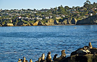
San Diego–Tijuana is an international transborder agglomeration, straddling the border of the adjacent North American coastal cities of San Diego, California, United States, and Tijuana, Baja California, Mexico. The 2020 population of the region was 5,456,577, making it the largest bi-national conurbation shared between the United States and Mexico, and the second-largest shared between the US and another country. The conurbation consists of the San Diego metropolitan area, in the United States and the municipalities of Tijuana, Rosarito Beach (126,980), and Tecate (108,440) in Mexico. It is the third most populous region in the California–Baja California region, smaller only than the metropolitan areas of Greater Los Angeles and the San Francisco Bay Area.

<span class="mw-page-title-main">SENTRI</span>

The Secure Electronic Network for Travelers Rapid Inspection (SENTRI) provides expedited U.S. Customs and Border Protection (CBP) processing, at the U.S.-Mexico border, of pre-approved travelers considered low-risk. Voluntarily applicants must undergo a thorough background check against criminal, customs, immigration, law enforcement, and terrorist databases; a 10-fingerprint law enforcement check; and a personal interview with a CBP Officer. The total enrollment fee is $122.50, and SENTRI status is valid for 5 years.

<span class="mw-page-title-main">Otay Mesa Port of Entry</span> Border crossing between Mexico and the U.S.

The Otay Mesa Port of Entry is one of three ports of entry (POE) in the San Diego–Tijuana metropolitan region, in the U.S. state of California, connecting Otay Mesa in the City of San Diego with the Otay Centenario borough of Tijuana. The facility was opened in 1983, and was constructed primarily to divert growing commercial truck traffic from the busy San Ysidro Port of Entry, located 5.2 miles (8.4 km) west. Since then, significant passenger vehicle and pedestrian traffic has grown as development in the area around the crossing has grown. Commercial importations through Otay Mesa accounts for billions of dollars' worth of freight.

<span class="mw-page-title-main">Tecate Port of Entry</span> Border crossing between Mexico and the U.S.

The Tecate Port of Entry is one three ports of entry in the San Diego–Tijuana metropolitan region. The land port is located between Tecate, California in San Diego County's Mountain Empire and Tecate Municipality in Baja California. It connects California State Route 188 with Paseo Lázaro Cárdenas, a spur of Mexico Federal Highway 2, as well as Federal Highway 3 to the south. It is a minor port in comparison to the larger San Ysidro Port of Entry and Otay Mesa Port of Entry. This is attributed in part to the fact that reaching the crossing on the US side requires driving on narrow, winding mountain roads.

<span class="mw-page-title-main">San Luis Port of Entry</span> Border crossing between Mexico and the U.S.

The San Luis Port of Entry has been a busy US port of entry since the early 1900s. It connects San Luis, Arizona, to San Luis Río Colorado, Sonora. It connects to U.S. Route 95 on the north and Mexican Federal Highway 2 as well as Sonora State Highway 40 on the south.

<span class="mw-page-title-main">Nogales-Morley Gate Port of Entry</span> Border crossing between Mexico and the U.S.

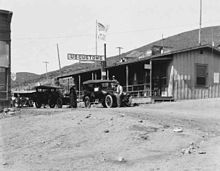
The Nogales Port of Entry evolved over time, rather than being planned. When an international fence divided Nogales in the early 20th century, vehicles were inspected at a gate at Grand Avenue, trains were inspected just east of there, and pedestrians were inspected further to the east at Morley Avenue. A small tile-roofed inspection station was completed in 1931 and was expanded in 1949. Substantial renovations were performed in 2011.

<span class="mw-page-title-main">El Paso PDN Port of Entry</span> Border crossing in El Paso, Texas, United States

The El Paso Paso del Norte (PDN) Port of Entry is a crossing of the United States–Mexico border, connecting the U.S. city of El Paso, Texas with the Mexican city of Ciudad Juárez, Chihuahua. It is among the busiest border crossings between the two countries: more than 10 million people enter the U.S. from Mexico each year at this location. The PDN Port of Entry is located at the Paso del Norte International Bridge, and is limited to northbound non-commercial traffic, although pedestrians may also cross the bridge in the southbound direction.

<span class="mw-page-title-main">United States Custom House (San Ysidro, California)</span> United States historic place

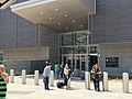
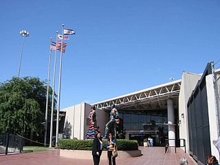
The United States Custom House in San Ysidro, San Diego, California, is a 1933 Spanish Revival building located 50 feet (15 m) north of the Mexico–United States border at the San Ysidro Port of Entry. It is listed on the National Register of Historic Places with the full historic name U.S. Inspection Station/U.S. Custom House and common name U.S. Custom House.

<span class="mw-page-title-main">Las Americas Premium Outlets</span> Shopping mall in San Diego, California, United States

Las Americas Premium Outlets is a 560,000 square feet (52,000 m2) outlet mall in San Ysidro, San Diego, California located directly on the Mexico–United States border just west of the San Ysidro Port of Entry at the new PedWest crossing from Tijuana to Virginia Avenue on the U.S. side.

<span class="mw-page-title-main">El Chaparral</span>

The El Chaparral port of entry or border crossing is as of 2012 the main vehicle crossing point from San Diego into Tijuana, Mexico, replacing the former entry point known as Puerta México which stood immediately east of El Chaparral. It is part of the San Ysidro Port of Entry. It is roughly in the same location as the former Virginia Avenue crossing, where trucks entering the US from Mexico prior to 1983, was located. The opening of El Chaparral roughly tripled the number of traffic lanes to 22, reducing wait times for vehicles entering Mexico.

The Otay Mesa East Port of Entry is a planned border crossing between San Diego and Tijuana, approximately 2 miles east of the existing Otay Mesa Port of Entry. The crossing will connect the Otay Centenario borough of Tijuana with East Otay Mesa in unincorporated San Diego County, an as-yet undeveloped area slotted for future development including a business park. Although the crossing will allow cars and pedestrians, it is mainly designed for trucks and commercial vehicles.

East Otay Mesa is an as-yet undeveloped area in the South Bay region of unincorporated San Diego County, southern California.

<span class="mw-page-title-main">Cross Border Xpress</span> Border crossing between Mexico and the U.S.

Cross Border Xpress (CBX), historically also called the Tijuana Cross-border Terminal and the Puerta de las Californias, is an airport terminal located in the Otay Mesa area of southern San Diego, California, United States, with an access bridge connecting it to the Tijuana International Airport in Tijuana, Baja California, Mexico. It opened on December 9, 2015. It makes Tijuana Airport a geographically binational airport. Unlike the binational airports serving the Swiss cities of Basel and Geneva, the CBX terminal is physically located in the United States but serves an airport whose main terminal and runways are in Mexico. A pedestrian bridge spans the United States–Mexico border and Via de la Juventud Oriente in Tijuana, connecting passenger terminals between the two countries. It was the creation of Ralph Nieders, who introduced the concept and infrastructure design in Mexico City in 1989 and San Diego in 1990. The structural scheme allows passengers originating in, and destined to the United States direct access to the Tijuana airport and equally gives Mexican and international carriers operating from the Tijuana airport direct access to the U.S. passenger market.

<span class="mw-page-title-main">Plaza Viva Tijuana</span>

Plaza Viva Tijuana is an open-air shopping center in the Empleados Federales neighborhood of Tijuana, located immediately across Frontera Street from what was, until 2012, the entrance to Mexico for all pedestrians crossing from the U.S. side of the San Ysidro of the border. It houses numerous pharmacies targeted at U.S. customers, handicraft and souvenir shops, restaurants, and one of Tijuana's largest gay nightclubs.

References

  1. 1 2 3 "Border Crossing/Entry Data". www.bts.gov. Bureau of Transportation Statistics. Archived from the original on June 8, 2023. Retrieved June 10, 2023.
  2. "San Ysidro LPOE Project Facts". www.gsa.gov. Retrieved November 27, 2018.
  3. Massive traffic cripples Tijuana border crossing, Reuters, April 19, 2007, retrieved June 22, 2011
  4. "San Ysidro Land Port of Entry". www.gsa.gov. Retrieved November 27, 2018.
  5. 1 2 "CBP Border Wait Times". apps.cbp.gov. Retrieved November 27, 2018.
  6. 1 2 San Ysidro Port of Entry Fact Sheet, http://www.dot.ca.gov/dist11/departments/planning/pdfs/GSA_SanYsidro_Fact_Sheet.pdf
  7. Project Overview, "Project Overview". Archived from the original on May 3, 2011. Retrieved May 9, 2011.
  8. MESA, OTAY (May 19, 2017). "Changes to Northbound Pedestrian Crossing at San Ysidro this Monday (05/22) - OTAYMESA" . Retrieved November 27, 2018.
  9. Dibble, Sandra (August 20, 2015). "New pedestrian crossing unveiled in Tijuana" . Retrieved November 27, 2018.
  10. Dibble, Sandra (September 24, 2012). "New southbound pedestrian crossing opens today at San Ysidro" . Retrieved November 27, 2018.
  11. 1 2 "Everything You Need to Know About PedWest, San Ysidro’s New Pedestrian Port of Entry", San Diego Red, July 2016
  12. "San Ysidro Port of Entry's New PedWest Facility, Transit Center Opens". www.gsa.gov. Retrieved November 27, 2018.
  13. Dibble, Sandra (August 2017). "New pedestrian entry to Mexico opens at PedWest" . Retrieved November 27, 2018.
  14. "San Diego Regional Chamber". SD Regional Chamber. August 4, 2017. Retrieved November 30, 2017.
  15. "PedWest crossing temporarily closed as part of changes at the California-Mexico border". SD Union Tribune. April 4, 2021. Retrieved July 2, 2021.
  16. "Inside Migrant Camp In Tijuana, Asylum-Seekers Are Waiting On A Plan". KPBS. March 16, 2021. Retrieved July 2, 2021.
  17. "PedWest pedestrian crossing at San Ysidro port of entry remains closed, CBP officials clarify". December 21, 2022.
  18. "Installation of New Technology Expected to Slow Border Crossings". KPBS. June 27, 2008. Retrieved April 18, 2011.The article states: "U.S. Customs and Border Protection officials are warning of delays this summer 2008 at California border crossings as they install new technology. They say the new tools will ultimately decrease wait times."
  19. Montes, Juan; Perez, Santiago; Whelan, Robbie (November 26, 2018). "U.S. Border Patrol Uses Tear Gas to Disperse Migrant Caravan". The Wall Street Journal. Retrieved December 30, 2018.
  20. Lind, Dara (November 26, 2018). "How a march at the US-Mexico border descended into tear gas and chaos". Vox. Retrieved December 30, 2018.
  21. Averbuch, Maya; Malkin, Elisabeth (November 25, 2018). "Migrants in Tijuana Run to U.S. Border, but Fall Back in Face of Tear Gas". The New York Times. ISSN   0362-4331 . Retrieved December 30, 2018.
  22. Specia, Megan; Gladstone, Rick (November 28, 2018). "Border Agents Shot Tear Gas into Mexico. Was It Legal?". The New York Times. Retrieved December 31, 2018.
  23. Design Overview, "The Miller Hull Partnership Unveils New Designs for San Ysidro U.S. Land Port of Entry" (PDF). www.gsa.gov. General Services Administration. August 2010. Archived from the original (PDF) on January 4, 2011. Retrieved June 10, 2023.
  24. Project Funding, http://www.gsa.gov/portal/content/103065
  25. "El Chaparral Expansion Project" (in Spanish). Tijuana. October 28, 2010. Archived from the original on July 16, 2011. Retrieved November 9, 2010.
  26. San Ysidro Construction Project, http://www.sdnn.com/sandiego/2010-01-25/mexico/san-ysidro-construction-project-expected-to-last-until-2015
  27. "San Ysidro LPOE Project Facts". www.gsa.gov. Retrieved November 30, 2017.
  28. "New Footbridge Opens to Public". NCB San Diego. Retrieved April 15, 2011.
  29. Several injured in border crossing roof collapse, San Diego Union-Tribune, retrieved September 14, 2011
  30. Spanish, El Chaparral Expansion Project, http://www.bajacalifornia.gob.mx/portal/noticia_completa.jsp?noticia=19316
  31. "New pedestrian crossing unveiled in Tijuana", Sandra Dibble, San Diego Union-Tribune", Aug. 19, 2015
  32. "First day of new pedestrian border crossing", San Diego Red, September 24, 2012
  33. Guerrero, Jean (July 15, 2016). "Pedestrian Crossing At San Ysidro Opens" . Retrieved November 27, 2018.
  34. "Adiós al puente chicanadas; ya funciona la obra definitiva en Ped West", Sintesis TV, September 12, 2016
  35. Srikrishnan, Maya (December 23, 2019). "Border Report: 10 Years and $741M Later, the Port of Entry Expansion Is Done". San Diego, California. Retrieved December 29, 2021.
  36. "The 5 Realign Project". www.gsa.gov. Retrieved November 30, 2017.
  37. "San Ysidro LPOE, Phase 3 | Clark Construction". www.clarkconstruction.com. Retrieved November 30, 2017.