Esperance mallee

Last updated

Esperance mallee
MAL Mallee 1 Clyde Hill NR III-2011.jpg
Sand mallee (Eucalyptus eremophila) at Clyde Hill Nature Reserve, Western Australia
Ecoregion AA1202.svg
location map showing the Esperance mallee ecoregion
Ecology
Realm Australasian
Biome Mediterranean forests, woodlands, and scrub
Borders
Geography
Area102,261 km2 (39,483 sq mi)
Country Australia
States Western Australia
Conservation
Conservation status Critical/endangered
Protected21,103 km2 (21%) [1]

Esperance mallee is an ecoregion on the south coast of Western Australia, a coastal strip where the predominant vegetation consists of short eucalyptus trees and shrubs. [2] [3] [4]

Contents

Location and description

A part of the Mediterranean forests, woodlands, and scrub biome, Esperance mallee is an aggregation of the Esperance Plains and Mallee Interim Biogeographic Regionalisation for Australia (IBRA) regions. [5]

Salmon gum (Eucalyptus salmonophloia) woodland along the Coolgardie-Esperance highway in Salmon Gums, Western Australia. Eucalyptus salmonophloia.jpg
Salmon gum (Eucalyptus salmonophloia) woodland along the Coolgardie-Esperance highway in Salmon Gums, Western Australia.
The IBRA regions, with the Esperance Plains in red IBRA 6.1 Esperance Plains.png
The IBRA regions, with the Esperance Plains in red
The IBRA regions, with Mallee in red IBRA 6.1 Mallee.png
The IBRA regions, with Mallee in red

Flora

Mallee is a generic term used to describe a number of eucalyptus trees that have an underground bulb called a lignotuber from which new buds can sprout following a forest fire. Mallee trees and accompanying shrubs are thus adapted to the poor soils, lack of rainfall, and regular fires, something common for the dry coast.

Fauna

Wildlife of the coast includes the highly venomous common death adder. Mammals include tiny honey possums (which feed on nectar of the kangaroo paw flowers) and the endangered western quoll. Birds include the endangered western whipbird, western ground parrots, red-winged fairywren, Australian white ibis, and the rare southwestern Cape Barren goose on the coast.

Threats and preservation

Much of the area is used as agricultural land and habitats are threatened by clearance. This is leading to fragmentation, over-irrigation, and wildlife becoming vulnerable to introduced species such as foxes.

The Esperance mallee ecoregion, with agricultural areas in yellow, and native vegetation in green. The IBRA boundaries are shown in red. Towns, road, and railways are also shown. Esperance Mallee ecoregion.png
The Esperance mallee ecoregion, with agricultural areas in yellow, and native vegetation in green. The IBRA boundaries are shown in red. Towns, road, and railways are also shown.

Protected areas

A 2017 assessment found that 21,103 km2, or 21%, of the ecoregion is in protected areas. [6] Protected areas include Cape Arid National Park, Fitzgerald River National Park, Frank Hann National Park, and Nuytsland Nature Reserve.

Related Research Articles

<span class="mw-page-title-main">Great Victoria Desert</span> Desert in Western Australia and South Australia

The Great Victoria Desert is a sparsely populated desert ecoregion and interim Australian bioregion in Western Australia and South Australia.

<span class="mw-page-title-main">North Western Ghats montane rain forests</span> Ecoregion in the Indian Peninsula

The North Western Ghats montane rain forests is a tropical moist broadleaf forest ecoregion of southwestern Indian peninsula. It covers an area of 30,900 square kilometers (11,900 sq mi), extending down the spine of the Western Ghauts range, from southernmost Gujarat through Damaon, Maharashtra, Goa & Karnataka. The montane rain forests are found above 1000 meters elevation, and are surrounded at lower elevations by the North Western Ghats moist deciduous forests.

<span class="mw-page-title-main">Carnarvon xeric shrublands</span> Terrestrial ecoregion in Western Australia

The Carnarvon xeric shrublands is a deserts and xeric shrublands ecoregion of Western Australia. The ecoregion is coterminous with the Carnarvon Interim Biogeographic Regionalisation for Australia (IBRA) bioregion.

<span class="mw-page-title-main">Maputaland coastal forest mosaic</span> Subtropical moist broadleaf forest ecoregion on the Indian Ocean coast of Southern Africa.

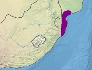
The Maputaland coastal forest mosaic is a subtropical moist broadleaf forest ecoregion on the Indian Ocean coast of Southern Africa. It covers an area of 29,961 square kilometres (11,568 sq mi) in southern Mozambique, Eswatini, and the KwaZulu-Natal Province of South Africa. Mozambique's capital Maputo lies within the ecoregion.

<span class="mw-page-title-main">Western Guinean lowland forests</span>

The Western Guinean lowland forests ecoregion is a tropical moist broadleaf forest ecoregion of West Africa. It is centered on Liberia, with portions in surrounding countries. It is the westernmost tropical rainforest in Africa, and has high levels of species endemism, with over 200 species of endemic plants.

<span class="mw-page-title-main">Crimean Submediterranean forest complex</span>

The Crimean Submediterranean forest complex is an ecoregion on the Black Sea coast of Russia and Ukraine. It is in the temperate broadleaf and mixed forests biome.

<span class="mw-page-title-main">Warren bioregion</span> Biogeographic region in southern Western Australia

Warren, also known as Karri Forest Region and the Jarrah-Karri forest and shrublands ecoregion, is a biogeographic region in southern Western Australia. Located in the southwest corner of Western Australia between Cape Naturaliste and Albany, it is bordered to the north and east by the Jarrah Forest region. Its defining characteristic is an extensive tall forest of Eucalyptus diversicolor (karri). This occurs on dissected, hilly ground, with a moderately wet climate. Karri is a valuable timber and much of the karri forest has been logged over, but less than a third has been cleared for agriculture. Recognised as a region under the Interim Biogeographic Regionalisation for Australia (IBRA), and as a terrestrial ecoregion by the World Wide Fund for Nature, it was first defined by Ludwig Diels in 1906.

<span class="mw-page-title-main">Tyrrhenian–Adriatic sclerophyllous and mixed forests</span> Ecoregion in Southern Europe

The Tyrrhenian-Adriatic sclerophyllous and mixed forests is an ecoregion in southern Italy, Sicily, Sardinia, Corsica, the Dalmatian Islands of Croatia, and Malta.

<span class="mw-page-title-main">Einasleigh Uplands</span> Bioregion in Queensland, Australia

The Einasleigh Uplands is an interim Australian bioregion, with vegetation consisting of savanna and woodland located on a large plateau in inland Queensland, Australia. It corresponds to the Einasleigh Uplands savanna ecoregion, as identified by the World Wildlife Fund.

<span class="mw-page-title-main">Southeast Australia temperate savanna</span>

The Southeast Australia temperate savanna ecoregion is a large area of grassland dotted with eucalyptus trees running north–south across central New South Wales, Australia.

<span class="mw-page-title-main">Coolgardie woodlands</span> Terrestrial ecoregion in Western Australia

The Coolgardie woodlands is an ecoregion in southern Western Australia. The predominant vegetation is woodlands and mallee scrub. The ecoregion is a transitional zone between the Mediterranean-climate forests, woodlands, and shrublands of Southwest Australia and the deserts and dry scrublands of the Australian interior.

<span class="mw-page-title-main">Eyre Yorke Block</span>

The Eyre Yorke Block, also known as the Eyre and Yorke mallee, is an interim Australian (IBRA) bioregion and a World Wildlife Fund ecoregion covering part of the Eyre Peninsula and all of Yorke Peninsula as well as land to its immediate east in South Australia.

<span class="mw-page-title-main">Murray Darling Depression</span>

The Murray Darling Depression , also known as the Murray-Darling woodlands and mallee, is a 19,717,651 HA biogeographic region and an ecoregion in southeastern Australia consisting of a wooded plain through which flow two of Australia's biggest rivers, the Murray and the Darling. There are several modern human settlements in the bioregion including Ivanhoe and Manilla, but the region also contains some of the oldest known human occupation sites in Australia.

<span class="mw-page-title-main">Naracoorte woodlands</span> Ecoregion in southern Australia

The Naracoorte woodlands is an ecoregion in southern Australia. It covers the Naracoorte coastal plain in southeastern South Australia and southwestern Victoria. It is coterminous with the Naracoorte Coastal Plain IBRA region. Only 10% of the ecoregion's area still has its original vegetation; most has been converted to agriculture and pasture.

<span class="mw-page-title-main">Southwest Australia savanna</span> Terrestrial ecoregion in Western Australia

The Southwest Australia savanna is an ecoregion in Western Australia.

<span class="mw-page-title-main">Central Ranges xeric scrub</span> Deserts and xeric shrublands ecoregion of Australia

The Central Ranges xeric scrub is a deserts and xeric shrublands ecoregion of Australia.

<span class="mw-page-title-main">Great Sandy–Tanami desert</span>

The Great Sandy-Tanami desert is a ecoregion of Western Australia extending into the Northern Territory. It is designated as a World Wildlife Fund region.

<span class="mw-page-title-main">Irrawaddy dry forests</span> Ecoregion in Myanmar

The Irrawaddy dry forests is a tropical dry broadleaf forest ecoregion in central Myanmar. The ecoregion occupies portions of the Irrawaddy, Sittaung, and Salween river basins, in areas with less than 800 mm of annual rainfall.

<span class="mw-page-title-main">Cape York Peninsula tropical savanna</span> Region in Queensland, Australia

The Cape York Peninsula tropical savanna is a tropical grasslands, savannas, and shrublands ecoregion in northern Australia. It occupies the Cape York Peninsula in Queensland, mainland Australia's northernmost point. It is coterminous with the Cape York Peninsula, an interim Australian bioregion.

<span class="mw-page-title-main">Peninsular Malaysian rain forests</span> Ecoregion on the Malay Peninsula

The Peninsular Malaysian rain forests is an ecoregion on the Malay Peninsula and adjacent islands. It is in the tropical and subtropical moist broadleaf forests biome.

References

  1. Eric Dinerstein, David Olson, et al. (2017). An Ecoregion-Based Approach to Protecting Half the Terrestrial Realm, BioScience, Volume 67, Issue 6, June 2017, Pages 534–545; Supplemental material 2 table S1b.
  2. "Map of Ecoregions 2017". Resolve. Retrieved 20 August 2021.
  3. "Esperance mallee". Digital Observatory for Protected Areas. Retrieved 20 August 2021.
  4. "Esperance mallee". The Encyclopedia of Earth. Retrieved 20 August 2021.
  5. "Esperance mallee". Terrestrial Ecoregions. World Wildlife Fund.
  6. Eric Dinerstein, David Olson, et al. (2017). An Ecoregion-Based Approach to Protecting Half the Terrestrial Realm, BioScience, Volume 67, Issue 6, June 2017, Pages 534–545; Supplemental material 2 table S1b.

Further reading

33°20′S121°10′E / 33.333°S 121.167°E / -33.333; 121.167