Excelsior Estates, Missouri

Last updated
Excelsior Estates, Missouri
[Incorporated 4th Class City in Missouri]
Clay County Missouri Incorporated and Unincorporated areas Excelsior Estates Highlighted.svg
Location of Excelsior Estates, Missouri
Coordinates: 39°23′24″N94°12′30″W / 39.39000°N 94.20833°W / 39.39000; -94.20833 Coordinates: 39°23′24″N94°12′30″W / 39.39000°N 94.20833°W / 39.39000; -94.20833
Country United States
State Missouri
Counties Ray, Clay
Area
[1]
  Total0.24 sq mi (0.62 km2)
  Land0.24 sq mi (0.62 km2)
  Water0.00 sq mi (0.00 km2)
Elevation
[2]
1,017 ft (310 m)
Population
 (2020)
  Total209
  Density867.22/sq mi (335.34/km2)
Time zone UTC-6 (Central (CST))
  Summer (DST) UTC-5 (CDT)
ZIP code
64024
Area code 816
FIPS code 29-23077 [3]
GNIS feature ID2398849 [2]

Excelsior Estates is a village in Clay and Ray counties in the U.S. state of Missouri and part of the Kansas City metropolitan area. The population was 209 at the 2020 census. [4]

Contents

Geography

According to the United States Census Bureau, the city has a total area of 0.24 square miles (0.62 km2), all land. [5]

Demographics

Historical population
CensusPop.Note
1990 274
2000 263−4.0%
2010 147−44.1%
2020 20942.2%
U.S. Decennial Census [6]

2010 census

As of the census [7] of 2010, there were 147 people, 57 households, and 35 families living in the village. The population density was 612.5 inhabitants per square mile (236.5/km2). There were 91 housing units at an average density of 379.2 per square mile (146.4/km2). The racial makeup of the village was 93.9% White, 2.0% Native American, and 4.1% from two or more races. Hispanic or Latino of any race were 6.1% of the population.

There were 57 households, of which 33.3% had children under the age of 18 living with them, 45.6% were married couples living together, 8.8% had a female householder with no husband present, 7.0% had a male householder with no wife present, and 38.6% were non-families. 31.6% of all households were made up of individuals, and 7.1% had someone living alone who was 65 years of age or older. The average household size was 2.58 and the average family size was 3.34.

The median age in the village was 38.9 years. 26.5% of residents were under the age of 18; 8.1% were between the ages of 18 and 24; 23.8% were from 25 to 44; 31.3% were from 45 to 64; and 10.2% were 65 years of age or older. The gender makeup of the village was 52.4% male and 47.6% female.

2000 census

As of the census [3] of 2000, there were 263 people, 95 households, and 66 families living in the village. The population density was 1,173.1 inhabitants per square mile (452.9/km2). There were 111 housing units at an average density of 495.1 per square mile (191.2/km2). The racial makeup of the village was 95.44% White, 0.76% African American, 0.76% Native American, 2.66% from other races, and 0.38% from two or more races. Hispanic or Latino of any race were 3.04% of the population.

There were 95 households, out of which 44.2% had children under the age of 18 living with them, 51.6% were married couples living together, 12.6% had a female householder with no husband present, and 30.5% were non-families. 28.4% of all households were made up of individuals, and 6.3% had someone living alone who was 65 years of age or older. The average household size was 2.77 and the average family size was 3.27.

In the city the population was spread out, with 35.0% under the age of 18, 4.2% from 18 to 24, 36.5% from 25 to 44, 18.6% from 45 to 64, and 5.7% who were 65 years of age or older. The median age was 32 years. For every 100 females, there were 99.2 males. For every 100 females age 18 and over, there were 98.8 males.

The median income for a household in the city was $26,667, and the median income for a family was $26,563. Males had a median income of $38,125 versus $15,500 for females. The per capita income for the city was $13,286. About 15.4% of families and 16.9% of the population were below the poverty line, including 20.5% of those under the age of eighteen and none of those 65 or over.

Related Research Articles

<span class="mw-page-title-main">Lyons, Michigan</span> Village in Michigan, United States

Lyons is a village in Ionia County in the U.S. state of Michigan. The population was 789 at the 2010 census. Most of the village is within Lyons Township. A small portion extends west into Ionia Township.

<span class="mw-page-title-main">Weston, Nebraska</span> Village in Nebraska, United States

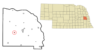
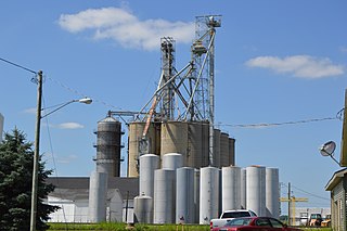
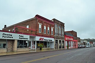
Weston is a village in Saunders County, Nebraska, United States. The population was 324 at the 2010 census.

<span class="mw-page-title-main">Country Club, Missouri</span> Village in Missouri, United States

Country Club is a village in Andrew County, Missouri, United States. The population was 2,449 at the 2010 census. It is part of the St. Joseph, MO–KS Metropolitan Statistical Area.

<span class="mw-page-title-main">Baldwin Park, Missouri</span> Village in Missouri, United States

Baldwin Park is a village in Cass County, Missouri, United States. The population was 92 at the 2010 census. It is part of the Kansas City metropolitan area.

<span class="mw-page-title-main">Holloway, Ohio</span> Village in Ohio, United States

Holloway is a village in Belmont County, Ohio, United States. The population was 330 at the 2020 census. It is part of the Wheeling metropolitan area. Holloway was laid out in 1883, and named after the local Holloway family.

<span class="mw-page-title-main">Cuyahoga Heights, Ohio</span> Village in Ohio, United States

Cuyahoga Heights is a village in Cuyahoga County, Ohio, United States. The population was 638 at the 2010 census.

<span class="mw-page-title-main">New Weston, Ohio</span> Village in Ohio, United States

New Weston is a village in Darke County, Ohio, United States. The population was 136 at the 2010 census.

<span class="mw-page-title-main">Addyston, Ohio</span> Village in Ohio, United States

Addyston is a village in Miami Township, Hamilton County, Ohio, United States, along the Ohio River. The population was 927 at the 2020 census.

<span class="mw-page-title-main">Darbyville, Ohio</span> Village in Ohio, United States

Darbyville is a village in Pickaway County, Ohio, United States. The population was 222 at the 2010 census.

<span class="mw-page-title-main">West Farmington, Ohio</span> Village in Trumbull, Ohio, United States

West Farmington is a village in northwestern Trumbull County, Ohio, United States, along the Grand River. The population was 542 at the 2020 census. It is part of the Youngstown–Warren metropolitan area.

<span class="mw-page-title-main">Elgin, Ohio</span> Village in Ohio, United States

Elgin is a village in Van Wert County, Ohio, United States. The population was 57 at the 2010 census. It is included within the Van Wert, Ohio Micropolitan Statistical Area.

<span class="mw-page-title-main">Bethlehem, West Virginia</span> Village in West Virginia, United States

Bethlehem is a village in Ohio County, West Virginia, United States. It is part of the Wheeling, West Virginia Metropolitan Statistical Area. The population was 2,499 at the 2010 census.

<span class="mw-page-title-main">Clearview, West Virginia</span> Village in West Virginia, United States

Clearview is a village in Ohio County, West Virginia, United States. It is part of the Wheeling, West Virginia Metropolitan Statistical Area. The population was 565 at the 2010 census.

<span class="mw-page-title-main">Kekoskee, Wisconsin</span> Village in Wisconsin, United States

Kekoskee is a village in Dodge County, Wisconsin, United States. The population was 161 at the 2010 census.

<span class="mw-page-title-main">Bay City, Wisconsin</span> Village in Wisconsin, United States

Bay City is a village on the Mississippi River in Pierce County, Wisconsin, United States. The population was 500 at the 2010 census.

<span class="mw-page-title-main">Hubbardston, Michigan</span> Village in Michigan, United States

Hubbardston is a village in the U.S. state of Michigan. It is mostly in North Plains Township in Ionia County, and partially in Lebanon Township in Clinton County. Its population was 395 at the 2010 census.

<span class="mw-page-title-main">Wilson, Ohio</span> Village in Ohio, United States

Wilson is a village in Belmont and Monroe counties in the U.S. state of Ohio. The population was 129 at the 2020 census. It is part of the Wheeling metropolitan area.

<span class="mw-page-title-main">Verona, Ohio</span> Village in Ohio, United States

Verona is a village in Montgomery and Preble counties in the U.S. state of Ohio. The population was 403 at the 2020 census. It is part of the Dayton Metropolitan Statistical Area.

<span class="mw-page-title-main">Bloomington, Wisconsin</span> Village in Wisconsin, United States

Bloomington is a village in Grant County, Wisconsin, United States. The population was 735 as of the 2010 census. The village is located within the Town of Bloomington.

<span class="mw-page-title-main">Aniwa, Wisconsin</span> Village in Wisconsin, United States

Aniwa is a village in Shawano County, Wisconsin, United States. The population was 260 at the 2010 census. The village is located within the Town of Aniwa. U.S. Route 45 runs north–south through the village.

References

  1. "ArcGIS REST Services Directory". United States Census Bureau. Retrieved August 28, 2022.
  2. 1 2 U.S. Geological Survey Geographic Names Information System: Excelsior Estates, Missouri
  3. 1 2 "U.S. Census website". United States Census Bureau . Retrieved 2008-01-31.
  4. "Explore Census Data". data.census.gov. Retrieved 2021-12-27.
  5. "US Gazetteer files 2010". United States Census Bureau. Archived from the original on 2012-01-25. Retrieved 2012-07-08.
  6. "Census of Population and Housing". Census.gov. Retrieved June 4, 2015.
  7. "U.S. Census website". United States Census Bureau . Retrieved 2012-07-08.