Randolph, Missouri

Last updated
Randolph, Missouri
Clay County Missouri Incorporated and Unincorporated areas Randolph Highlighted.svg
Location of Randolph, Missouri
Coordinates: 39°09′21″N94°29′34″W / 39.15583°N 94.49278°W / 39.15583; -94.49278 Coordinates: 39°09′21″N94°29′34″W / 39.15583°N 94.49278°W / 39.15583; -94.49278
Country United States
State Missouri
County Clay
Area
[1]
  Total0.34 sq mi (0.88 km2)
  Land0.32 sq mi (0.84 km2)
  Water0.02 sq mi (0.05 km2)
Elevation
[2]
758 ft (231 m)
Population
 (2020)
  Total57
  Density176.47/sq mi (68.12/km2)
Time zone UTC-6 (Central (CST))
  Summer (DST) UTC-5 (CDT)
ZIP codes
64117, 64161
Area code 816
FIPS code 29-60590 [3]
GNIS feature ID2399039 [2]

Randolph is a city in Clay County, Missouri, United States. [4] The population was 57 at the 2020 census. It is completely surrounded by Kansas City and is a part of the Kansas City metropolitan area.

Contents

History

An early variant name was "East Kansas City". [5] The name of the post office changed from East Kansas City to Randolph in 1920, and the post office closed in 1928. [6]

Geography

According to the United States Census Bureau, the city has a total area of 0.35 square miles (0.91 km2), of which 0.33 square miles (0.85 km2) is land and 0.02 square miles (0.05 km2) is water. [7] Randolph is on the banks of the Missouri River. It is surrounded by Kansas City on all land borders, and the opposite side of the Missouri is also Kansas City. [8]

Demographics

Historical population
CensusPop.Note
1930 138
1940 18836.2%
1950 2069.6%
1960 2196.3%
1970 106−51.6%
1980 91−14.2%
1990 60−34.1%
2000 47−21.7%
2010 5210.6%
2020 579.6%
U.S. Decennial Census [9]

2010 census

As of the census [10] of 2010, there were 52 people, 24 households, and 14 families living in the city. The population density was 157.6 inhabitants per square mile (60.8/km2). There were 26 housing units at an average density of 78.8 per square mile (30.4/km2). The racial makeup of the city was 98.1% White and 1.9% Asian. Hispanic or Latino of any race were 1.9% of the population.

There were 24 households, of which 20.8% had children under the age of 18 living with them, 41.7% were married couples living together, 12.5% had a female householder with no husband present, 4.2% had a male householder with no wife present, and 41.7% were non-families. 33.3% of all households were made up of individuals, and 8.4% had someone living alone who was 65 years of age or older. The average household size was 2.17 and the average family size was 2.71.

The median age in the city was 47.5 years. 17.3% of residents were under the age of 18; 7.7% were between the ages of 18 and 24; 19.2% were from 25 to 44; 34.5% were from 45 to 64; and 21.2% were 65 years of age or older. The gender makeup of the city was 59.6% male and 40.4% female.

2000 census

As of the census [3] of 2000, there were 47 people, 20 households, and 14 families living in the city. The population density was 137.7 inhabitants per square mile (53.2/km2). There were 22 housing units at an average density of 64.5 per square mile (24.9/km2). The racial makeup of the city was 95.74% White, and 4.26% from two or more races.

There were 20 households, out of which 15.0% had children under the age of 18 living with them, 55.0% were married couples living together, 15.0% had a female householder with no husband present, and 30.0% were non-families. 20.0% of all households were made up of individuals, and 5.0% had someone living alone who was 65 years of age or older. The average household size was 2.35 and the average family size was 2.64.

In the city the population was spread out, with 14.9% under the age of 18, 6.4% from 18 to 24, 38.3% from 25 to 44, 21.3% from 45 to 64, and 19.1% who were 65 years of age or older. The median age was 39 years. For every 100 females, there were 123.8 males. For every 100 females age 18 and over, there were 110.5 males.

The median income for a household in the city was $53,750, and the median income for a family was $53,750. Males had a median income of $31,667 versus $35,000 for females. The per capita income for the city was $23,067. None of the population and none of the families were below the poverty line.

Education

Residents are zoned to North Kansas City School District. [11] Randolph is zoned to Topping Elementary School, Maple Park Middle School, and Winnetonka High School. [12]

Audit

In 2010, Randolph was cited by Missouri State Auditor Susan Montee for violating the state's speed trap law, by funding over 73% of the city budget from traffic violations. [13]

Related Research Articles

<span class="mw-page-title-main">Oak Hill, Kansas</span> City in Clay County, Kansas

Oak Hill is a city in Clay County, Kansas, United States. As of the 2020 census, the population of the city was 24.

<span class="mw-page-title-main">Randolph, Kansas</span> City in Riley County, Kansas

Randolph is a city in Riley County, Kansas, United States. As of the 2020 census, the population of the city was 159.

<span class="mw-page-title-main">Amoret, Missouri</span> City in Missouri, United States

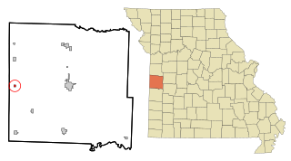
Amoret is a city in western Bates County, Missouri, and is part of the Kansas City metropolitan area within the United States. The population was 133 at the 2020 census.

<span class="mw-page-title-main">Avondale, Missouri</span> City in Missouri, United States

Avondale is a city in Clay County, Missouri, United States. The population was 436 at the 2020 census. It is part of the Kansas City metropolitan area.

<span class="mw-page-title-main">Birmingham, Missouri</span> Village in Missouri, United States

Birmingham is a village in Clay County, Missouri, United States. The population was 189 at the 2020 census. It is part of the Kansas City metropolitan area.

<span class="mw-page-title-main">Claycomo, Missouri</span> Village in Missouri, United States

Claycomo is a village in Clay County, Missouri, United States, as part of the Kansas City metropolitan area. Its name is a portmanteau of "Clay County, MO". The population was 1,343 at the 2020 census. Ford Motor Company owns the Kansas City Assembly Plant (KCAP) in Claycomo, which builds the Ford F-150 pickup trucks and Ford Transit vans.

<span class="mw-page-title-main">Gladstone, Missouri</span> City in Missouri, United States

Gladstone is a city in Clay County, Missouri, United States and a suburb of Kansas City. The City of Gladstone is located only 10 minutes from downtown Kansas City, and 10 minutes from Kansas City International Airport. As of the 2020 census, the city population was 27,063. It is part of the Kansas City metropolitan area.

<span class="mw-page-title-main">Glenaire, Missouri</span> City in Missouri, United States

Glenaire is a city in Clay County, Missouri, United States. The population was 539 at the 2020 census. The city is completely surrounded by the city of Liberty. It was originally referred to as "Interurban Heights" or "Belleview" because of the interurban train that ran through the area and stopped at the Belleview depot near the Belleview Dairy. It is part of the Kansas City metropolitan area.

<span class="mw-page-title-main">Mosby, Missouri</span> City in Missouri, United States

Mosby is a city in Clay County, Missouri, United States, along the Fishing River. The population was 101 at the 2020 census. It is part of the Kansas City metropolitan area.

<span class="mw-page-title-main">Oaks, Missouri</span> Village in Missouri, United States

Oaks is a village in Clay County, Missouri, United States. The population was 128 at the 2020 census. It is part of the Kansas City metropolitan area.

<span class="mw-page-title-main">Oakview, Missouri</span> Village in Missouri, United States

Oakview is a village in Clay County, Missouri, United States. The population was 366 at the 2020 census. It is part of the Kansas City metropolitan area.

<span class="mw-page-title-main">Oakwood, Missouri</span> Village in Missouri, United States

Oakwood is a village in Clay County, Missouri, United States. The population was 198 at the 2020 census. It is part of the Kansas City metropolitan area.

<span class="mw-page-title-main">Prathersville, Missouri</span> Village in Missouri, United States

Prathersville is a village in Clay County, Missouri, United States. The population was 121 at the 2020 census. It is part of the Kansas City metropolitan area.

<span class="mw-page-title-main">Smithville, Missouri</span> City in Missouri, United States

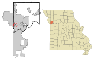
Smithville is a city in Clay and Platte counties in the U.S. state of Missouri and is part of the Kansas City metropolitan area, along the Little Platte River. The population was 10,406 at the 2020 United States Census.

<span class="mw-page-title-main">Higbee, Missouri</span> City in Missouri, United States

Higbee is a city in southern Randolph County, Missouri, United States. The population was 568 at the 2010 census. Barrel-making company A&K Cooperage, Barrel 53 Cooperage and Woodsmen Distilling are based in Higbee.

<span class="mw-page-title-main">Oakwood Park, Missouri</span> Village in Missouri, United States

Oakwood Park is a village in Clay County, Missouri, United States. The population was 189 at the 2020 census. It is part of the Kansas City metropolitan area.

<span class="mw-page-title-main">Pleasant Valley, Missouri</span> Place in Missouri, United States

Pleasant Valley is a city in Clay County, Missouri, United States. The population was 2,743 at the 2020 census. It is part of the Kansas City metropolitan area.

<span class="mw-page-title-main">Dearborn, Missouri</span> City in Missouri, United States

Dearborn is a city in Buchanan and Platte counties in the U.S. state of Missouri and is part of the Kansas City metropolitan area. The population was 496 at the 2010 census.

<span class="mw-page-title-main">Excelsior Estates, Missouri</span> 4th Class City in Missouri in the United States

Excelsior Estates is a village in Clay and Ray counties in the U.S. state of Missouri and part of the Kansas City metropolitan area. The population was 209 at the 2020 census.

<span class="mw-page-title-main">Holt, Missouri</span> City in Missouri, United States

Holt is a city in Clay and Clinton counties in the U.S. state of Missouri and is part of the Kansas City metropolitan area. The population was 471 at the 2020 census.

References

  1. "ArcGIS REST Services Directory". United States Census Bureau. Retrieved August 28, 2022.
  2. 1 2 U.S. Geological Survey Geographic Names Information System: Randolph, Missouri
  3. 1 2 "U.S. Census website". United States Census Bureau . Retrieved 2008-01-31.
  4. "Board of Election Commissioners, Clay County, MO". Archived from the original on 2011-05-15. Retrieved 2011-02-12.
  5. "Clay County Place Names, 1928–1945 (archived)". The State Historical Society of Missouri. Archived from the original on 24 June 2016. Retrieved 21 September 2016.{{cite web}}: CS1 maint: bot: original URL status unknown (link)
  6. "Post Offices". Jim Forte Postal History. Retrieved 21 September 2016.
  7. "US Gazetteer files 2010". United States Census Bureau. Archived from the original on 2012-07-02. Retrieved 2012-07-08.
  8. ANdriot, John L. Township Atlas of the United States" (McLean, Virginia: Andriot Associates, 1979) p. 366
  9. "Census of Population and Housing". Census.gov. Retrieved June 4, 2015.
  10. "U.S. Census website". United States Census Bureau . Retrieved 2012-07-08.
  11. "2020 CENSUS - SCHOOL DISTRICT REFERENCE MAP: Clay County, MO" (PDF). U.S. Census Bureau. Archived (PDF) from the original on 2022-09-10. Retrieved 2022-09-09.
  12. "District Attendance Areas" (PDF). North Kansas City School District. Archived (PDF) from the original on 2021-04-22. Retrieved 2022-09-09.
  13. Frankel, Todd. "Missouri's first official speed-trap town fingered in audit" St. Louis Post-Dispatch, 15 September 2010.