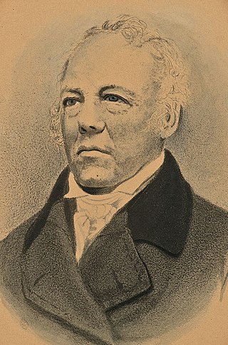
Albion Keith Parris was the 5th Governor of Maine, a United States representative from the District of Maine, Massachusetts, a United States senator from Maine, a United States district judge of the United States District Court for the District of Maine, an associate justice of the Maine Supreme Judicial Court and the 2nd Comptroller of the Currency for the United States Department of the Treasury.
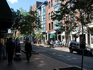
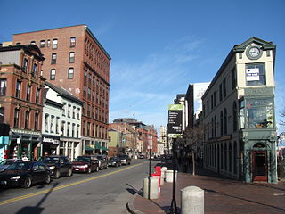
The Old Port is a district of Portland, Maine, known for its cobblestone streets, 19th-century brick buildings and fishing piers. The district contains boutiques, restaurants and bars. Because of its reputation for nightlife, the Old Port is a popular destination for tourists and locals alike.

The great fire of Portland, Maine, sometimes known as the 1866 great fire of Portland, occurred on July 4, 1866—the second Independence Day after the end of the American Civil War. Five years before the Great Chicago Fire, this was the greatest fire yet seen in an American city. It started in a boat house on Commercial Street, likely caused by a firecracker or a cigar ash. The fire spread to a lumber yard and on to a sugar house, then spread across the city, eventually burning out on Munjoy Hill in the city's east end. Two people died in the fire and 10,000 people were made homeless. 1,800 buildings were burned to the ground. This included the federal Exchange Building by which was replaced with the custom house. Soon after the fire, Portland native and acclaimed poet Henry Wadsworth Longfellow described his old home town: "Desolation, desolation, desolation. It reminded me of Pompeii, that 'sepult city."
The Arts District is a section of downtown Portland, Maine’s designated in 1995 as to promote the cultural community and creative economy of the city. It covers a large part of upper Congress Street towards the West End and spans Congress Street toward the East ending at Portland City Hall and its Merrill Auditorium concert hall.
Commercial Street is a downtown street in the Old Port of Portland, Maine, United States. It is part of U.S. Route 1A. It became the Old Port's waterfront in the early 20th century, replacing Fore Street, after land was reclaimed from the waters of Casco Bay and the Fore River.

Franklin Street is a four-lane street in Portland, Maine, United States. It is a major corridor for traffic from Interstate 295 to Portland's downtown, Old Port, and to other neighborhoods located on the Portland peninsula. Part of U.S. Route 1A, it is around 0.77 miles (1.24 km) long, running between Marginal Way in the northwest and Commercial Street in the southeast.
Congress Street is the main street in Portland, Maine. Around 5.77 miles (9.29 km) long, it stretches from County Road, Portland's southwestern border with Westbrook, through a number of neighborhoods, before ending overlooking the Eastern Promenade on Munjoy Hill. In March 2009, the Portland City Council designated much of the inner portion of Congress Street a historic district. The western section of the street includes the city's Arts District.

The Press Herald Building is a historic building in Portland, Maine, built in 1923 and expanded in 1948. It is strategically located across Congress Street from Portland City Hall. It was occupied by the Portland Press Herald newspaper until 2010. In 2015, the renovated building reopened as the Press Hotel.

The University of Maine School of Law Building is a former academic building in Portland, Maine. Adjacent to the University of Southern Maine's Portland campus, the 8 story building was designed by the local architectural firm of Wadsworth, Boston, Dimick, Mercer and Weatherill and completed in 1972 at a cost of $2.7 million. It expanded in 1993 to include more space on the first floor to accommodate the law library. It is a rare example of Brutalist architecture in Maine. It was built to house the University of Maine School of Law, which had previously been located downtown at 68 High Street.

The Printers' Exchange Block is a historic commercial building located at 103–107 Exchange Street in the Old Port of Portland, Maine. The building, which was designed in 1866 by Charles Q. Clapp, was built the same year. It wraps around the block that stands at the intersections of Exchange, Federal and Market Streets. Its alternative addresses have been given as 174–178 Federal Street and 114–116 Market Street during its history.
Chandler's Wharf is a historic wharf in Portland, Maine, on the edge of the Fore River. It stands across Commercial Street from Dana Street and, on the waterfront side, between Long Wharf and Widgery Wharf.
George Munjoy was an early settler in what was Falmouth, Province of Maine. Munjoy Hill, in today's Portland, Maine, is named for him, as was Peaks Island for a period.

Fore Street is a downtown street in Portland, Maine, United States. Dating to 1724, it runs for around 1 mile (1.6 km), from the Eastern Promenade on Munjoy Hill in the northeast to Pleasant Street in the southwest. Near its midsection, Fore Street crosses Franklin Street. It splits briefly at Boothby Square, shortly after passing the United States Custom House. The street passes through the Old Port district.

Woodfords Corner is a neighborhood and major intersection in Portland, Maine, United States. Centered around the intersections of Forest Avenue and Woodford Street, it is named for brothers Chauncey, Ebenezer and Isaiah Woodford, merchants from Connecticut who settled in the area.

Middle Street is a downtown street in Portland, Maine, United States. Dating to 1724, it runs for around 0.46 miles (0.74 km), from an intersection with Union Street, Spring Street and Temple Street in the southwest, to Hancock Street, at the foot of Munjoy Hill, in the northeast. It formerly originated at what was then known as Market Square, but 20th-century redevelopment saw the section between Monument Square and Free Street pedestrianized, and the remaining section—around The Maine Lobsterman monument on Temple Street—erased.

India Street is a downtown street and neighborhood in Portland, Maine, United States. Situated near the western foot of Munjoy Hill, it runs for around 0.28 miles (0.45 km), from Congress Street in the northwest to Commercial Street and Thames Street in the southeast. It was the city's first street, and the location of the first settlement of European immigrants to the city in the 17th century. There are thirty handmade bricks in the sidewalk commemorating the neighborhood's notable events. In 1680, when Thomas Danforth was Deputy Governor of the Massachusetts Bay Colony, the street was known as Broad Street. After the incorporation of the Town of Falmouth in 1718, the street was known as High King Street.

Moulton Street is a historic downtown street in Portland, Maine, United States. Situated in the heart of the Old Port, it runs for around 233 feet (71 m), from Fore Street in the northwest to Commercial Street in the southeast. One-way from Fore Street, its surface is cobblestoned, with brick sidewalks. The street is named for William H. Moulton, president of the Cumberland Bank, which stood at the corner of Moulton and Commercial.
Federal Street is a historic downtown street in Portland, Maine, United States. It runs for around 0.56 miles (0.90 km), from Monument Way, in Monument Square, in the southwest to Mountfort Street, at the foot of Munjoy Hill, in the northeast. Its middle section was wiped out by the widening of Franklin Street in 1967.

Stevens Avenue is a major street in the Deering neighborhood of Portland, Maine, United States. Part of Maine State Route 9 from Woodford Street southward, it runs for around 2 miles (3.2 km) from Forest Avenue, at Morrill's Corner, in the north to Outer Congress Street in the south. Stevens Avenue passes to the west of Woodfords Corner. Between Morrills Corner and Woodfords Corner, Stevens Avenue is linked to Forest Avenue by several side streets.

Mountfort Street is a historic downtown street in Portland, Maine, United States. It runs for around 0.22 miles (0.35 km), from Congress Street, at the foot of Munjoy Hill, in the northwest to Fore Street in the southeast. It forms the eastern boundary of Eastern Cemetery, which was established in 1668.

