
Portland is the most populous city in the U.S. state of Maine and the seat of Cumberland County. Portland's population was 68,408 in April 2020. The Greater Portland metropolitan area has a population of approximately 550,000 people. Historically tied to commercial shipping, the marine economy, and light industry, Portland's economy in the 21st century relies mostly on the service sector. The Port of Portland is the second-largest tonnage seaport in the New England area as of 2019.
Munjoy Hill is both a neighborhood and prominent geographical feature of Portland, Maine. It is located east of downtown and south of East Deering, the neighborhood it is connected to by Tukey's Bridge. The neighborhood historically had a large Irish and Italian American population.

The railroad history of Portland, Maine, began in 1842 with the arrival of the Portland, Saco & Portsmouth Railway (PS&P). Most of the rail activity in Portland revolved around agricultural goods bound for export and import freight from Europe. Yet Maine's largest city also enjoyed 125 years of continuous passenger rail service, from 1842 until 1967, and Amtrak began serving the city in 2001. For most of Portland's history, passenger train schedules were designed with intercity travel rather than daily commuting in mind; passenger activities were mostly confined to intercity travel from Portland to Boston, Montreal, Nova Scotia, and points west.
Kennedy Park is a neighborhood in East Bayside in downtown Portland, Maine, built around a park, athletic fields, basketball courts, a playground and the Boyd Street Urban Garden.
Portland, Maine, is home to many neighborhoods.
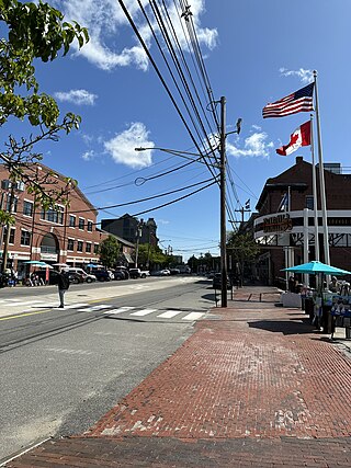
Commercial Street is a downtown street in the Old Port of Portland, Maine, United States. It is part of U.S. Route 1A. It became the Old Port's waterfront in the early 20th century, replacing Fore Street, after land was reclaimed from the waters of Casco Bay and the Fore River.

Franklin Street is a four-lane street in Portland, Maine, United States. It is a major corridor for traffic from Interstate 295 to Portland's downtown, Old Port, and to other neighborhoods located on the Portland peninsula. Part of U.S. Route 1A, it is around 0.77 miles (1.24 km) long, running between Marginal Way in the northwest and Commercial Street in the southeast.
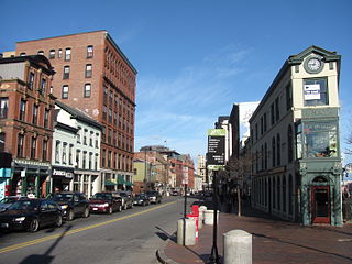
Congress Street is the main street in Portland, Maine. Around 5.77 miles (9.29 km) long, it stretches from County Road, Portland's southwestern border with Westbrook, through a number of neighborhoods, before ending overlooking the Eastern Promenade on Munjoy Hill. In March 2009, the Portland City Council designated much of the inner portion of Congress Street a historic district. The western section of the street includes the city's Arts District.
Libbytown is a neighborhood in Portland, Maine, United States. One of the oldest neighborhoods in the city, it is located between the Stroudwater, Rosemont, Oakdale, and Parkside neighborhoods, and is separated from the city of South Portland by the Fore River. It extends to the intersection of Stevens Avenue and Congress Street.

Forest Avenue is a major street in Portland, Maine, United States. It runs for around 4.78 miles (7.69 km) from Bridgton Road in the northwest to Congress Street, in downtown Portland, in the southeast. It is the main artery for traffic entering and leaving Portland to and from the north via city streets. The street ends in Portland's Arts District.

Cumberland Avenue is a downtown street in Portland, Maine, United States. Part of Maine State Route 100, it runs for around 1.57 miles (2.53 km) from Merrill Street, on Munjoy Hill in the northeast, to Deering Avenue in the southwest.

Fore Street is a downtown street in Portland, Maine, United States. Dating to 1724, it runs for around 1 mile (1.6 km), from the Eastern Promenade on Munjoy Hill in the northeast to Pleasant Street in the southwest. Near its midsection, Fore Street crosses Franklin Street. It splits briefly at Boothby Square, shortly after passing the United States Custom House. The street passes through the Old Port district.

Woodfords Corner is a neighborhood and major intersection in Portland, Maine, United States. Centered around the intersections of Forest Avenue and Woodford Street, it is named for brothers Chauncey, Ebenezer and Isaiah Woodford, merchants from Connecticut who settled in the area.

Middle Street is a downtown street in Portland, Maine, United States. Dating to 1724, it runs for around 0.46 miles (0.74 km), from an intersection with Union Street, Spring Street and Temple Street in the southwest, to Hancock Street, at the foot of Munjoy Hill, in the northeast. It formerly originated at what was then known as Market Square, but 20th-century redevelopment saw the section between Monument Square and Free Street pedestrianized, and the remaining section—around The Maine Lobsterman monument on Temple Street—erased.

High Street is a downtown street in Portland, Maine, United States. It runs one-way for around 0.81 miles (1.30 km), from Commercial Street in the southeast to Forest Avenue in the northwest. It is one of the three main routes crossing the Portland peninsula in this direction, the other two being State Street and Franklin Street. Part of the street passes through the Spring Street Historic District and the city's Arts District.
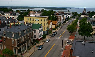
India Street is a downtown street and neighborhood in Portland, Maine, United States. Situated near the western foot of Munjoy Hill, it runs for around 0.28 miles (0.45 km), from Congress Street in the northwest to Commercial Street and Thames Street in the southeast. It was the city's first street, and the location of the first settlement of European immigrants to the city in the 17th century. There are thirty handmade bricks in the sidewalk commemorating the neighborhood's notable events. In 1680, when Thomas Danforth was Deputy Governor of the Massachusetts Bay Colony, the street was known as Broad Street. After the incorporation of the Town of Falmouth in 1718, the street was known as High King Street.
Portland station was a passenger rail station on the Grand Trunk Railway in Portland, Maine, United States. It stood to at the foot of India Street, Portland's first street, between 1903 and 1966. It was one of Portland's four railroad stations for the Portland and Forest Avenue Railroad Company over its history, and one of the two stations in the city at the time of the station's construction. The other was Union Station, which has also been demolished.
Federal Street is a historic downtown street in Portland, Maine, United States. It runs for around 0.56 miles (0.90 km), from Monument Way, in Monument Square, in the southwest to Mountfort Street, at the foot of Munjoy Hill, in the northeast. Its middle section was wiped out by the widening of Franklin Street in 1967.

Stevens Avenue is a major street in the Deering neighborhood of Portland, Maine, United States. Part of Maine State Route 9 from Woodford Street southward, it runs for around 2 miles (3.2 km) from Forest Avenue, at Morrill's Corner, in the north to Outer Congress Street in the south. Stevens Avenue passes to the west of Woodfords Corner. Between Morrills Corner and Woodfords Corner, Stevens Avenue is linked to Forest Avenue by several side streets.
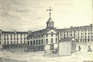
The Market House of Portland, Maine, was located in what was then known as Market Square or Haymarket Square between 1825 and 1888, when it was demolished. In 1833, the building was modified to become Portland's first city hall. The Soldiers' and Sailors' Monument, which now stands in its place, was dedicated in 1891.


