
Portland is the most populous city in the U.S. state of Maine and the seat of Cumberland County. Portland's population was 68,408 in April 2020. The Greater Portland metropolitan area has a population of approximately 550,000 people. Historically tied to commercial shipping, the marine economy, and light industry, Portland's economy in the 21st century relies mostly on the service sector. The Port of Portland is the second-largest tonnage seaport in the New England area as of 2019.

Deering High School (DHS) is a public high school located on Stevens Avenue in Portland, Maine, United States. The school is part of the Portland Public Schools district.

John Calvin Stevens was an American architect who worked in the Shingle Style, in which he was a major innovator, and the Colonial Revival style. He designed more than 1,000 buildings in the state of Maine.

The railroad history of Portland, Maine, began in 1842 with the arrival of the Portland, Saco & Portsmouth Railway (PS&P). Most of the rail activity in Portland revolved around agricultural goods bound for export and import freight from Europe. Yet Maine's largest city also enjoyed 125 years of continuous passenger rail service, from 1842 until 1967, and Amtrak began serving the city in 2001. For most of Portland's history, passenger train schedules were designed with intercity travel rather than daily commuting in mind; passenger activities were mostly confined to intercity travel from Portland to Boston, Montreal, Nova Scotia, and points west.
The West End is a downtown neighborhood in Portland, Maine. It is located on the western side of Portland's peninsula primarily on Bramhall Hill and is noted for its architecture and history. The neighborhood is home to many late 19th- and early 20th-century homes and, in 2010, it was called "one of the best preserved Victorian neighborhoods in the country". The Western Promenade, a park laid out in 1836, overlooks the forests and small settlements of Southwestern Maine, along with the distant White Mountains. Other historic structures include 68 High Street, The Gothic House, Brown House, Butler House, Ingraham House, Morrill Mansion and the Minott House.
Portland, Maine, is home to many neighborhoods.

The Sparrow House is an historic house at 35 Arlington Street in the Woodfords Corner and Back Cove neighborhood of Portland, Maine. Built in 1852, it is a well-preserved example of Gothic Revival architecture. It was listed on the National Register of Historic Places in 1982.

Franklin Street is a four-lane street in Portland, Maine, United States. It is a major corridor for traffic from Interstate 295 to Portland's downtown, Old Port, and to other neighborhoods located on the Portland peninsula. Part of U.S. Route 1A, it is around 0.77 miles (1.24 km) long, running between Marginal Way in the northwest and Commercial Street in the southeast.
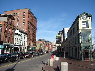
Congress Street is the main street in Portland, Maine. Around 5.77 miles (9.29 km) long, it stretches from County Road, Portland's southwestern border with Westbrook, through a number of neighborhoods, before ending overlooking the Eastern Promenade on Munjoy Hill. In March 2009, the Portland City Council designated much of the inner portion of Congress Street a historic district. The western section of the street includes the city's Arts District.

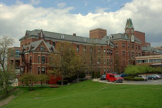
The Westbrook College Historic District is a historic district in the Deering neighborhood of Portland, Maine. It is centered on the campus of the former Westbrook College, founded in 1831 as the nation's first coeducational boarding school. The college merged with the University of New England in 1996. The district, which includes six buildings constructed between 1833 and 1952, was added to the National Register of Historic Places in 1977.

The Sixth and Forest Historic District is located in Des Moines, Iowa, United States. It is a Victorian era suburban commercial district on the northeastern and northwestern corners of the junction of 6th and Forest Avenues, and originally contained six buildings. The buildings on the northeast corner have subsequently been torn down. The historic district has been listed on the National Register of Historic Places since 1996. It is a part of the Towards a Greater Des Moines MPS.

Donald Valle (1908–1977) was an American restaurateur who owned and managed the eponymously named Valle's Steak House, from 1933 until his death in 1977.

Forest Avenue is a major street in Portland, Maine, United States. It runs for around 4.78 miles (7.69 km) from Bridgton Road in the northwest to Congress Street, in downtown Portland, in the southeast. It is the main artery for traffic entering and leaving Portland to and from the north via city streets. The street ends in Portland's Arts District.

Cumberland Avenue is a downtown street in Portland, Maine, United States. Part of Maine State Route 100, it runs for around 1.57 miles (2.53 km) from Merrill Street, on Munjoy Hill in the northeast, to Deering Avenue in the southwest.
Chauncey Woodford was a merchant and an early settler of Deering, Maine. Portland's Woodfords Corner is now named for him and his brothers, Ebenezer and Isaiah.

State Street is a downtown street in Portland, Maine, United States. Part of Maine State Route 77, it runs one-way for around 0.95 miles (1.53 km), from an intersection with Forest Avenue in the northwest to York Street in the southeast. It is one of the three main routes crossing the Portland peninsula in this direction, the other two being High Street and Franklin Street. Part of the street passes through the Deering Street Historic District.

High Street is a downtown street in Portland, Maine, United States. It runs one-way for around 0.81 miles (1.30 km), from Commercial Street in the southeast to Forest Avenue in the northwest. It is one of the three main routes crossing the Portland peninsula in this direction, the other two being State Street and Franklin Street. Part of the street passes through the Spring Street Historic District and the city's Arts District.
India Street is a downtown street and neighborhood in Portland, Maine, United States. Situated near the western foot of Munjoy Hill, it runs for around 0.28 miles (0.45 km), from Congress Street in the northwest to Commercial Street and Thames Street in the southeast. It was the city's first street, and the location of the first settlement of European immigrants to the city in the 17th century. There are thirty handmade bricks in the sidewalk commemorating the neighborhood's notable events. In 1680, when Thomas Danforth was Deputy Governor of the Massachusetts Bay Colony, the street was known as Broad Street. After the incorporation of the Town of Falmouth in 1718, the street was known as High King Street.
Stevens Avenue is a major street in the Deering neighborhood of Portland, Maine, United States. Part of Maine State Route 9 from Woodford Street southward, it runs for around 2 miles (3.2 km) from Forest Avenue, at Morrill's Corner, in the north to Outer Congress Street in the south. Stevens Avenue passes to the west of Woodfords Corner. Between Morrills Corner and Woodfords Corner, Stevens Avenue is linked to Forest Avenue by several side streets.

Morrills Corner is a neighborhood and major intersection in Portland, Maine, United States. Centered around the intersections of Forest Avenue, Allen Avenue and Stevens Avenue. It was once home to some of the oldest families in what was the city of Deering.

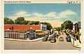 A postcard, dated between 1930 and 1945, showing a northwestern view of Woodfords Corner, with Forest Avenue being crossed by Woodford Avenue.
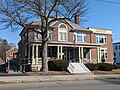 The Woodfords Club circa 2024.
 The historic Sparrow House.
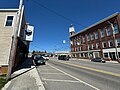 The Independent Order of Odd Fellows Block, looking northwest along Forest Avenue toward Woodfords Corner
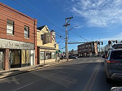


