Mapped data
| | This section is empty. You can help by adding to it. (January 2018) |
Fire history, the ecological science of the study of the history of wildfires, is a subdiscipline of fire ecology. Patterns of forest fires in historical and prehistorical time provide information relevant to the pattern of vegetation in modern landscapes. It provides an estimate of the historical range of variability of a natural disturbance regime, and can be used to identify the processes affecting the occurrence of fire. Fire history reconstructions are achieved by compiling atlases of past fires, using the tree ring record from fire scars and tree ages, and the charcoal record from soils and sediments.
Sustained wildfire can only exist once oxygen levels and fuel sources were present in sufficient quantities. Between 400 and 450 million year ago, fire became a feature of the landscape. [1] : 11–14 The presence of fusain (fossil charcoal), beginning in the early Carboniferous attests to this fire history and forms an important element of the Cretaceous–Paleogene boundary. [1] : 11–14 [2]
| | This section is empty. You can help by adding to it. (January 2018) |
This section needs additional citations for verification .(January 2018) |


The growth record of a tree in seasonal climates is preserved in the growth rings in the stem wood; the field of dendrochronology is the study of the record of climate and other events preserved in the growth record. Each growth ring represents one year of life. The thickness of each ring indicates the amount of wood produced during that growing season. At the beginning of the growing season large cells are able to quickly divide creating a light colored wood. When growth slows down, generally in colder months, a darker wood is created from smaller cells dividing more slowly. Thus, one year is represented by a light inner ring and a darker outer ring. [3]
Rings can be counted from dead trees as well as stumps left behind from logging. A sample can be collected from a living tree using tools like the increment borer. The increment borer is a hollow steel tube used to extract a core sample from a tree’s trunk. The growth rings in a core sample are counted to determine the age of that tree. Ages of stand-replacing fires may be determined by determining the cohort-age of trees that established after a fire. For example, tree-ring dating of large stands will show the age of the forest, and may provide an estimate of when the last large disturbance event occurred.
Sometimes growth rings exhibit scars. A fire scar forms when heat kills the vascular cambium beneath the bark, which then heals over subsequent years as growth rings curl over the scarred area, thus protecting the tree from infection. [4] This method can be used to date the year a fire occurred. Observing the scars establishes the timeline of a forest fire and the time between fires at a site. Surveying many trees over a large sample area provides a view to individual fire events and the overall fire regime. Not all tree species scar and show evidence of fire. Most pine species in the subgenus Pinus readily produce scars that are protected by resin; such scarring on other trees may result in death, leaving no fire record behind.
Prior to Euro-American settlement in western North America, fire histories from scars preserved in ponderosa pine forests often reveal a pattern of frequent fire (often with 5 to 20 year intervals in a single area), with a pattern in time and space strongly related to past variations in climate. [5] Fuel reduction from grazing and fire suppression greatly reduced the amount of fire in dry forests over the last 100 years.
A study by Arne Buechiling and William L. Baker in 2004 identified 41 fire events beginning in 1533 in a 9200-ha study area north of Estes Park, Colorado. They sampled 3461 tree cores and 212 fire scars. [6] Fire scar data provided greater insight into the fire event parameters. Of the 41 fires, 22 where high-severity crown fires, 7 low-severity surface fires, and 8 mixed-severity fires. Fires larger than 300 ha were few, but composed a substantial proportion of the area burned since 1700. Drought periods led to larger fires.
There is little known about the fire history in some places. Central Europe for instance has a lack of intact forests with old growth trees or an abundance of dead or cut down trees that can be used to reconstruct the past fire regimes. An exception to this lacking history is the Bialowieza Primeval Forest in Poland. [7] A group of researchers were able to use a 350-year tree-ring fire record to reconstruct the fire history in precise detail. This is a shining example of how the method can be used in a place with lost or no written history of a fire regime.
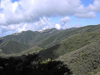
Chaparral is a shrubland plant community found primarily in California, in southern Oregon and in the northern portion of the Baja California Peninsula in Mexico. It is shaped by a Mediterranean climate and infrequent, high-intensity crown fires. Chaparral are typically embedded with hard sclerophyllous evergreen leaves, as contrasted with the associated soft-leaved, drought-deciduous, scrub community of coastal sage scrub, found often on drier, southern facing slopes within the chaparral biome. Three other closely related chaparral shrubland systems occur in central Arizona, western Texas, and along the eastern side of central Mexico's mountain chains (mexical), all having summer rains in contrast to the Mediterranean climate of other chaparral formations. Chaparral comprises 9% of California's wildland vegetation and contains 20% of its plant species.

Fire is the rapid oxidation of a material in the exothermic chemical process of combustion, releasing heat, light, and various reaction products. At a certain point in the combustion reaction, called the ignition point, flames are produced. The flame is the visible portion of the fire. Flames consist primarily of carbon dioxide, water vapor, oxygen and nitrogen. If hot enough, the gases may become ionized to produce plasma. Depending on the substances alight, and any impurities outside, the color of the flame and the fire's intensity will be different.

A wildfire, forest fire, bushfire, wildland fire or rural fire is an unplanned, uncontrolled and unpredictable fire in an area of combustible vegetation. Depending on the type of vegetation present, a wildfire may be more specifically identified as a bushfire, desert fire, grass fire, hill fire, peat fire, prairie fire, vegetation fire, or veld fire. Some natural forest ecosystems depend on wildfire.

A savanna or savannah is a mixed woodland-grassland ecosystem characterised by the trees being sufficiently widely spaced so that the canopy does not close. The open canopy allows sufficient light to reach the ground to support an unbroken herbaceous layer consisting primarily of grasses. According to Britannica, there exists four savanna forms; savanna woodland where trees and shrubs form a light canopy, tree savanna with scattered trees and shrubs, shrub savanna with distributed shrubs, and grass savanna where trees and shrubs are mostly nonexistent.
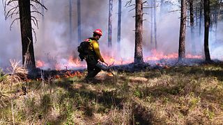
A controlled or prescribed burn, also known as hazard reduction burning, backfire, swailing, or a burn-off, is a fire set intentionally for purposes of forest management, fire suppression, farming, prairie restoration or greenhouse gas abatement. A controlled burn may also refer to the intentional burning of slash and fuels through burn piles. Fire is a natural part of both forest and grassland ecology and controlled fire can be a tool for foresters.

Rangelands are grasslands, shrublands, woodlands, wetlands, and deserts that are grazed by domestic livestock or wild animals. Types of rangelands include tallgrass and shortgrass prairies, desert grasslands and shrublands, woodlands, savannas, chaparrals, steppes, and tundras. Rangelands do not include forests lacking grazable understory vegetation, barren desert, farmland, or land covered by solid rock, concrete and/or glaciers.
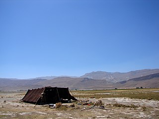
Pastoralism is a form of animal husbandry where domesticated animals are released onto large vegetated outdoor lands (pastures) for grazing, historically by nomadic people who moved around with their herds. The animal species involved include cattle, camels, goats, yaks, llamas, reindeer, horses and sheep.

Fire ecology is a scientific discipline concerned with natural processes involving fire in an ecosystem and the ecological effects, the interactions between fire and the abiotic and biotic components of an ecosystem, and the role as an ecosystem process. Many ecosystems, particularly prairie, savanna, chaparral and coniferous forests, have evolved with fire as an essential contributor to habitat vitality and renewal. Many plant species in fire-affected environments use fire to germinate, establish, or to reproduce. Wildfire suppression not only endangers these species, but also the animals that depend upon them.
Wildfires consume live and dead fuels, destabilize physical and ecological landscapes, and impact human social and economic systems. Post-fire seeding was initially used to stabilize soils. More recently it is being used to recover post wildfire plant species, manage invasive non-native plant populations and establish valued vegetation compositions.
Prior to European colonization of the Americas, indigenous peoples used controlled burns to modify the landscape. The controlled fires were part of the environmental cycles and maintenance of wildlife habitats that sustained the cultures and economies of the Indigenous peoples of the Americas. Parts of what was initially perceived by colonists as "untouched, pristine" wilderness in North America was actually the cumulative result of those occasional managed fires creating an intentional mosaic of grasslands and forests across North America, sustained and managed by the original peoples of the landbase. However, other research indicates "paleo-climate, paleo-ecology and archaeological records suggest that native peoples were not modifying their immediate environments to a great degree."

In computational science, wildfire modeling is concerned with numerical simulation of wildland fires in order to understand and predict fire behavior. Wildfire modeling can ultimately aid wildland fire suppression, namely increase safety of firefighters and the public, reduce risk, and minimize damage. Wildfire modeling can also aid in protecting ecosystems, watersheds, and air quality.
A fire regime is the pattern, frequency, and intensity of the bushfires and wildfires that prevail in an area over long periods of time. It is an integral part of fire ecology, and renewal for certain types of ecosystems. A fire regime describes the spatial and temporal patterns and ecosystem impacts of fire on the landscape, and provides an integrative approach to identifying the impacts of fire at an ecosystem or landscape level. If fires are too frequent, plants may be killed before they have matured, or before they have set sufficient seed to ensure population recovery. If fires are too infrequent, plants may mature, senesce, and die without ever releasing their seed.
Wildfire suppression in the United States has had a long and varied history. For most of the 20th century, any form of wildland fire, whether it was naturally caused or otherwise, was quickly suppressed for fear of uncontrollable and destructive conflagrations such as the Peshtigo Fire in 1871 and the Great Fire of 1910. In the 1960s, policies governing wildfire suppression changed due to ecological studies that recognized fire as a natural process necessary for new growth. Today, policies advocating complete fire suppression have been exchanged for those who encourage wildland fire use, or the allowing of fire to act as a tool, such as the case with controlled burns.
The wildland–urban interface (WUI) is a zone of transition between wilderness and land developed by human activity – an area where a built environment meets or intermingles with a natural environment. Human settlements in the WUI are at a greater risk of catastrophic wildfire.

Forest restoration is defined as “actions to re-instate ecological processes, which accelerate recovery of forest structure, ecological functioning and biodiversity levels towards those typical of climax forest” i.e. the end-stage of natural forest succession. Climax forests are relatively stable ecosystems that have developed the maximum biomass, structural complexity and species diversity that are possible within the limits imposed by climate and soil and without continued disturbance from humans. Climax forest is therefore the target ecosystem, which defines the ultimate aim of forest restoration. Since climate is a major factor that determines climax forest composition, global climate change may result in changing restoration aims. Additionally, the potential impacts of climate change on restoration goals must be taken into account, as changes in temperature and precipitation patterns may alter the composition and distribution of climax forests.

Complex early seral forests, or snag forests, are ecosystems that occupy potentially forested sites after a stand-replacement disturbance and before re-establishment of a closed forest canopy. They are generated by natural disturbances such as wildfire or insect outbreaks that reset ecological succession processes and follow a pathway that is influenced by biological legacies that were not removed during the initial disturbance. Complex early seral forests develop with rich biodiversity because the remaining biomass provides resources to many life forms and because of habitat heterogeneity provided by the disturbances that generated them. In this and other ways, complex early seral forests differ from simplified early successional forests created by logging. Complex early seral forest habitat is threatened from fire suppression, thinning, and post-fire or post-insect outbreak logging.

Pyrogeography is the study of the past, present, and projected distribution of wildfire. Wildland fire occurs under certain conditions of climate, vegetation, topography, and sources of ignition, such that it has its own biogeography, or pattern in space and time. The earliest published evidence of the term appears to be in the mid-1990s, and the meaning was primarily related to mapping fires The current understanding of pyrogeography emerged in the 2000s as a combination of biogeography and fire ecology, facilitated by the availability of global-scale datasets of fire occurrence, vegetation cover, and climate. Pyrogeography has also been placed at the juncture of biology, the geophysical environment, and society and cultural influences on fire.
Fire adaptations are life history traits of plants and animals that help them survive wildfire or to use resources created by wildfire. These traits can help plants and animals increase their survival rates during a fire and/or reproduce offspring after a fire. Both plants and animals have multiple strategies for surviving and reproducing after fire.

Triodia scariosa, is more commonly known as porcupine grass or spinifex, and belongs to the endemic Australian grass genusTriodia. The species is perennial and evergreen and individuals grow in mounds, called hummocks, that reach up to ~1m in height. The leaves are ~30 cm long, 1mm in diameter, needlepointed and rigid, and its inflorescence is a narrow, loose panicle that forms a flowering stalk up to ~2m in height. The name is derived from Latin; Triodia refers to the three-toothed lobes of the lemma, and scariosa is in reference to the thin, dry glume. The species is common to Mallee (MVG14) and Hummock grassland (MVG20) communities, in arid and semi-arid regions of Australia.