Fire regime

Last updated

A fire regime is the pattern, frequency, and intensity of the bushfires and wildfires that prevail in an area over long periods of time. [1] It is an integral part of fire ecology, and renewal for certain types of ecosystems. A fire regime describes the spatial and temporal patterns and ecosystem impacts of fire on the landscape, and provides an integrative approach to identifying the impacts of fire at an ecosystem or landscape level. [2] If fires are too frequent, plants may be killed before they have matured, or before they have set sufficient seed to ensure population recovery. If fires are too infrequent, plants may mature, senesce, and die without ever releasing their seed.

Contents

Fire regimes can change with the spatial and temporal variations in topography, climate, and fuel. Understanding the historic fire regime is important for understanding and predicting future fire regime changes and the interactions between fire and climates. [2]

Characteristics

Fire regime classification by ecosystem type. Fire severity and frequency is linked to vegetation type. Wildland Fire in Ecosystems 15-1-2.png
Fire regime classification by ecosystem type. Fire severity and frequency is linked to vegetation type.

Fire regimes are characterized by a variety of factors including vegetation composition, fuel structure, climate and weather patterns, and topography. Because fire regimes are highly dependent on the landscape and ecosystem in which they occur, there is no standard classification for fire regimes. However, characteristics such as those described below are commonly used to characterize fire regimes on a broad scale. [2] Other factors such as post-disturbance successional stages and types of previous management on the landscape may also be used to describe a fire regime's characteristics. Climate directly impacts the frequency, size, and severity of fires, while also affecting the vegetation structure and composition. Fire regimes are also impacted by topography, slope exposure, landscape management, and ignition (which may be human or lightning-caused). [4] Animals are another agent capable of affecting and changing fire regime by modifying control factors of fires such as amount, structure, or condition of fuel. [5]

Although characteristics of fire regimes can vary based on regional differences, at a minimum fire regimes are characterized based on an assessment of the impacts on the vegetation (severity) and when and how often fires occur in a given landscape (expressed as fire interval and fire rotation). Fire severity is the impact of fire on the ecosystem, which may include the degree of vegetative mortality, the depth of burn, or other factors which may be site specific. The fire interval is the number of years between fires and is highly dependent on spatial scales. Fire rotation is a measure of the amount of fire in a landscape (the amount of time required to burn an area the size of the study area). The fire rotation statistic is best used for large areas that have mapped historic fire events. [6]

Other fire regime classifications may incorporate fire type (such as ground fires, surface fires, and crown fires), fire size, fire intensity, seasonality, and degree of variability within fire regimes. Ground fires use glowing combustion to burn organic matter in the soil. Surface fires burn leaf litter, fallen branches, and ground plants. Crown fires burn through to the top layer of tree foliage. [7] Fire-line intensity is the energy released per unit of measurement per unit of time and is usually a description of flaming combustion. [4] Seasonality is the period of time during the year that the fuels of a specific ecosystem can ignite. [8]

Spatial and temporal scales

Fire regimes can be characterized by a wide variety of spatial and temporal scales which may range from highly site-specific to regional scales and from a few years to thousands of years. Understanding the variability of the fire regime across these scales is crucial to understanding fire regimes and accomplishing conservation or management goals. [9] Distinctions should be made between "fire history" and "historic fire regimes". Fire history is a more general term that measures the frequency of fires in a landscape. It may not always be possible to describe the type or severity of these past fire events depending on data availability. Historic fire regimes describe the characteristics of fires across a landscape and the relationship and interactions between ecosystem structure and processes. [2]

LANDFIRE (Landscape Fire and Resource Management Planning Tools), is a collaborative program between the U.S. Department of Agriculture and Department of the Interior that provides geospatial data on fire regime characteristics such as vegetation, habitat, carbon sources/sinks, fire, etc. The data is used to help map fire events and look at broad scale fire regime effects. LANDFIRE's Fire Regime Group Map.jpg
LANDFIRE (Landscape Fire and Resource Management Planning Tools), is a collaborative program between the U.S. Department of Agriculture and Department of the Interior that provides geospatial data on fire regime characteristics such as vegetation, habitat, carbon sources/sinks, fire, etc. The data is used to help map fire events and look at broad scale fire regime effects.

Mapping

Recent fire history can be recorded on fire maps and atlases, often using remote sensing. The Canadian National Fire Database is a record of large fire events since 1980, is the first nationwide database of its kind. It includes point locations of all fires larger than 200 ha from 1959–1999. The United States has the Monitoring Trends in Burn Severity (MTBS) Project which uses satellite data to map fires from 1984 onward. MTBS maps fire severity within the areas burned and provides a standard on fire perimeters and severity for all fires within the U.S. Applications for projects such as these are used in modeling interactions between fire climate and vegetation. [10]

The Landscape Fire and Resource Management Planning Tools (LANDFIRE) classification is another example of a mapping and modeling system used in the U.S. that collects and analyzes vegetative, fire, and fuel characteristics of fire regimes across a variety of landscapes. LANDFIRE is unique in that it uses both historic fire regimes and current fire regimes to analyze differences between past and present characteristics. It describes fire regimes based on their fire frequencies and severities which helps detect changes in fire regimes over time which is helpful in assessing fire climate effects at regional and landscape scales. [11]

Aging past fire events

Understanding historic fire regimes can be difficult, as fire history data is not always reliable or available. Past fire events can be identified using fire scar analysis on trees, age distributions of stands, charcoal samples, or vegetation changes seen over long periods of time. Examining past fire events and historic fire regimes provides a means of examining trends in vegetation and fire-climate interactions over a long time frame. The variability and fire-climate-vegetation interactions of fire regimes are able to be examined in greater detail and over much longer time periods (thousands of years) rather than just decades as provided by examining historical fire records. Studies have found strong correlations between past climate and fire frequency and extent using these historical fire aging methods. [12]

Although fire history data is useful for understanding past fire regimes, changes in fire management, climate, and vegetation do not allow the continuation of the same fire regimes into the future. Models that examine past fire-climate relationships are the best predictors of future fire regime changes. [12]

Effects of an altered fire regime

Biota that are able to survive and adapt to their particular fire regimes can receive significant benefits: the ability to regrow stronger, greater protection against fire and disease, or new space to grow in formerly occupied locations. [1] As a fire regime changes, species may begin to suffer. [1] [13] Decreasing fire intervals negatively affect the ability of fire-killed species to recover to pre-disturbance levels, leading to longer recovery times. Some species, such as resprouters, are better able to withstand changing fire regimes compared to obligate seeders. However, many fire-killed species may be unable to recover if shortened fire intervals persist over time. [13] Lengthened fire intervals will negatively affect fire-adapted species, some of which depend upon fire for reproduction. In fire-adapted plant communities with stand-replacing crown fires, recruitment occurs in the first year following a fire event.[ citation needed ]

Climate change

NASA imagery showing the interrelatedness of climate and fire. Active fires are represented by red dots. Satellite Image of Earth's Interrelated Systems and Climate - GPN-2002-000121.jpg
NASA imagery showing the interrelatedness of climate and fire. Active fires are represented by red dots.

Climate change has affected fire regimes globally, with models projecting higher fire frequencies and reduced plant growth as a result of warmer, drier climates. This is predicted to affect fire-intolerant woody species in particular by reducing plant recruitment, growth, and survival, which shortens the fire intervals within these landscapes causing plant extirpation or extinction. A recent model identifying the impacts of climate change and altered fire regimes and plant communities predicts that woody plant extinctions will increase, causing changes in ecosystem structure, composition, and carbon storage. The fire-climate interactions of a changing climate are predicted to reduce population recovery for plants solely dependent on seed production for re-population. As climates shift to warmer and drier, seedling recruitment may become poor or non-existent. This post-fire recruitment shift means that a decrease in precipitation causes an increase in dry or drought-prone years which causes a decrease in seed recruitment probability. This reduced seed recruitment also is exacerbated by increased fire severity. [15]

Warmer climates are projected to increase fire activity and lengthen fire seasons globally. The annual number of extreme fire weather days is projected to increase as increasing temperatures, reduced relative humidity, increased wind speeds, and increased dry fuel loads result in higher fire intensities and severity. These changes will shorten fire intervals, which will reduce the time for plants to accumulate seeds and potentially allowing for selection of more flammable species. [16] The result of these fire interval shifts have been studied globally. A study in southeast Australia found that widespread losses of mountain ash following prolonged wildfire seasons have burned 87% of the species range. Subsequent re-burns of immature mountain ash led to complete regeneration failure and conversion of forest cover to shrubs and grasslands. [17] These patterns have also been seen in the Mediterranean forests of western North America chaparral regions. These climatic shifts in conjunction with increased fire frequency and shorter fire intervals are causing vegetative communities to shift their rates of growth, reproduction, and reduce post-disturbance recruitment rates. [15]

Examples

Bushfire is especially important in Australia, where much of the vegetation has evolved in the presence of regular fires caused by the Aboriginal practice of firestick farming. As result, components of the vegetation are adapted to and dependent upon a particular fire regime. Disruption of that fire regime can affect their survival. An example of fire regime dependent species is the Banksia species which is both fire-sensitive and serotinous. In Banksia species, fire also triggers the release of seed, ensuring population recovery. In an ideal fire regime, a plant would need to have sufficient time to mature and build an adequately large bank of seed before the next fire kills it and triggers seed release.[ citation needed ]

The California chaparral and woodlands ecoregion, covering a large portion of the U.S. state, is dependent on periodic natural wildfires for optimal health and renewal. [3] A study showed that the increasing rural-urban fringe interface and wildfire suppression practices of the last century have resulted in an increased vulnerability to less frequent, more severe wildfires. The study claimed fire suppression increased fuel in coniferous forests. [4] Upon analysis of California Statewide Fire History Database from 1910–1999, it was actually found that fire frequency and the area burned have not declined, furthermore, fire size has not increased. [18] Chaparral fire suppression, unlike fire suppression in coniferous forests, has not affected the natural fire regime, according to a study conducted by the United States Geological Survey.

Invasive species effects

Cheatgrass

One example of an invasive species that changed fire regime in Western North America is Bromus tectorum . [19] Historical fire return intervals in the Snake River Plain sagebrush was 60–110 years, but currently, due to the presence of cheat grass, it burns every 5 years. [19] The cheat grass is a continuous source of fuel thus changing the fuel characteristics of the ecosystem. Frequent fire makes it difficult to impossible for native vegetation to fully recover. [19]

Brazilian pepper tree

Brazilian pepper trees are encroaching on native plant communities throughout the southeastern U.S. and causing changes to the frequency and severity of fire regimes and ecosystems. Schinus terebinthifolia, loof en vrugte, a, Pretoria.jpg
Brazilian pepper trees are encroaching on native plant communities throughout the southeastern U.S. and causing changes to the frequency and severity of fire regimes and ecosystems.

Another example of invasive species affecting fire regimes can be found with the spread of the Brazilian pepper tree (Schinus terebinthifolia) on native plant communities. Native to Brazil, Argentina, and Paraguay, the plant was introduced as an ornamental species and has now established itself in areas well outside of its native range. Populations exist in Australia, South Africa, the Mediterranean, southern Asia, and the southeastern United States. Brazilian pepper is often found in disturbed soils and substrates and often outcompetes native plant communities creating monoculture-like conditions. South Florida near the Everglades National Park has particularly been affected by its spread, with some studies reporting only 7 species within (6) 100 m2 plots. As Brazilian pepper moves into an area, it creates a sub-canopy layer that often outcompetes grasses and ground cover species. This changes the vegetative cover and densities of the landscape contributing a changed fire regime. [21]

Brazilian peppers are fire-adapted and produce rapidly growing sprouts following fire events, although plant size and stand density are important in determining the post-fire response, with younger plants having higher mortality rates. [21] Fire frequency plays some role in Brazilian pepper establishment, with areas of frequent fires displaying lower abundances of the plant in contrast to areas not regularly burned. A recent model found that a 4-year fire-return interval would eradicate an initial 100 pepper female population within 25 years. [22] In areas where Brazilian pepper occurs, fire regimes have been altered greatly due to fire exclusion and human settlement. Historically, these areas experienced frequent, low-severity fires. Brazilian pepper may create a shaded humid understory and reduce fine fuel loads in areas of historically frequent fire, which therefore increases the fire-return interval thus negatively affecting the fire-adapted plant community. [21]

See also

Related Research Articles

<span class="mw-page-title-main">Chaparral</span> Shrubland plant community in western North America

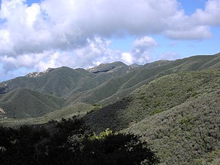
Chaparral is a shrubland plant community found primarily in California, in southern Oregon and in the northern portion of the Baja California Peninsula in Mexico. It is shaped by a Mediterranean climate and infrequent, high-intensity crown fires.

<i>Bromus tectorum</i> Species of grass

Bromus tectorum, known as downy brome, drooping brome or cheatgrass, is a winter annual grass native to Europe, southwestern Asia, and northern Africa, but has become invasive in many other areas. It now is present in most of Europe, southern Russia, Japan, South Africa, Australia, New Zealand, Iceland, Greenland, North America and western Central Asia. In the eastern US B. tectorum is common along roadsides and as a crop weed, but usually does not dominate an ecosystem. It has become a dominant species in the Intermountain West and parts of Canada, and displays especially invasive behavior in the sagebrush steppe ecosystems where it has been listed as noxious weed. B. tectorum often enters the site in an area that has been disturbed, and then quickly expands into the surrounding area through its rapid growth and prolific seed production.

<span class="mw-page-title-main">Controlled burn</span> Technique to reduce potential fuel for wildfire through managed burning

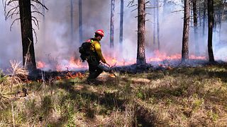
A controlled or prescribed (Rx) burn is the practice of intentionally setting a fire to change the assemblage of vegetation and decaying material in a landscape. The purpose could be for forest management, ecological restoration, land clearing or wildfire fuel management. A controlled burn may also refer to the intentional burning of slash and fuels through burn piles. Controlled burns may also be referred to as hazard reduction burning, backfire, swailing or a burn-off. In industrialized countries, controlled burning regulations and permits are usually overseen by fire control authorities.

<span class="mw-page-title-main">Fire ecology</span> Study of fire in ecosystems

Fire ecology is a scientific discipline concerned with the effects of fire on natural ecosystems. Many ecosystems, particularly prairie, savanna, chaparral and coniferous forests, have evolved with fire as an essential contributor to habitat vitality and renewal. Many plant species in fire-affected environments use fire to germinate, establish, or to reproduce. Wildfire suppression not only endangers these species, but also the animals that depend upon them.

<span class="mw-page-title-main">Disturbance (ecology)</span> Temporary change in environmental conditions that causes a pronounced change in an ecosystem

In ecology, a disturbance is a temporary change in environmental conditions that causes a pronounced change in an ecosystem. Disturbances often act quickly and with great effect, to alter the physical structure or arrangement of biotic and abiotic elements. A disturbance can also occur over a long period of time and can impact the biodiversity within an ecosystem.

Wildfires consume live and dead fuels, destabilize physical and ecological landscapes, and impact human social and economic systems. Post-fire seeding was initially used to stabilize soils. More recently it is being used to recover post wildfire plant species, manage invasive non-native plant populations and establish valued vegetation compositions.

Prior to the European colonization of the Americas, indigenous peoples used fire to modify the landscape. This influence over the fire regime was part of the environmental cycles and maintenance of wildlife habitats that sustained the cultures and economies of the Indigenous peoples of the Americas. What was initially perceived by colonists as "untouched, pristine" wilderness in North America was the cumulative result of the Indigenous use of fire, creating an mosaic of grasslands and forests across North America, sustained and managed by the peoples indigenous to the landscape.

<span class="mw-page-title-main">Fossil record of fire</span> Fossilized evidence of wildfires on Earth

The fossil record of fire first appears with the establishment of a land-based flora in the Middle Ordovician period, 470 million years ago, permitting the accumulation of oxygen in the atmosphere as never before, as the new hordes of land plants pumped it out as a waste product. When this concentration rose above 13%, it permitted the possibility of wildfire. Wildfire is first recorded in the Late Silurian fossil record, 420 million years ago, by fossils of charcoalified plants. Apart from a controversial gap in the Late Devonian, charcoal is present ever since. The level of atmospheric oxygen is closely related to the prevalence of charcoal: clearly oxygen is the key factor in the abundance of wildfire. Fire also became more abundant when grasses radiated and became the dominant component of many ecosystems, around 6 to 7 million years ago; this kindling provided tinder which allowed for the more rapid spread of fire. These widespread fires may have initiated a positive feedback process, whereby they produced a warmer, drier climate more conducive to fire.

<span class="mw-page-title-main">Mediterranean forests, woodlands, and scrub</span> Habitat defined by the World Wide Fund for Nature

Mediterranean forests, woodlands and scrub is a biome defined by the World Wide Fund for Nature. The biome is generally characterized by dry summers and rainy winters, although in some areas rainfall may be uniform. Summers are typically hot in low-lying inland locations but can be cool near colder seas. Winters are typically mild to cool in low-lying locations but can be cold in inland and higher locations. All these ecoregions are highly distinctive, collectively harboring 10% of the Earth's plant species.

<span class="mw-page-title-main">Forest restoration</span>

Forest restoration is defined as “actions to re-instate ecological processes, which accelerate recovery of forest structure, ecological functioning and biodiversity levels towards those typical of climax forest” i.e. the end-stage of natural forest succession. Climax forests are relatively stable ecosystems that have developed the maximum biomass, structural complexity and species diversity that are possible within the limits imposed by climate and soil and without continued disturbance from humans. Climax forest is therefore the target ecosystem, which defines the ultimate aim of forest restoration. Since climate is a major factor that determines climax forest composition, global climate change may result in changing restoration aims. Additionally, the potential impacts of climate change on restoration goals must be taken into account, as changes in temperature and precipitation patterns may alter the composition and distribution of climax forests.

<span class="mw-page-title-main">Complex early seral forest</span> Type of ecosystem present after a major disturbance

Complex early seral forests, or snag forests, are ecosystems that occupy potentially forested sites after a stand-replacement disturbance and before re-establishment of a closed forest canopy. They are generated by natural disturbances such as wildfire or insect outbreaks that reset ecological succession processes and follow a pathway that is influenced by biological legacies that were not removed during the initial disturbance. Complex early seral forests develop with rich biodiversity because the remaining biomass provides resources to many life forms and because of habitat heterogeneity provided by the disturbances that generated them. In this and other ways, complex early seral forests differ from simplified early successional forests created by logging. Complex early seral forest habitat is threatened from fire suppression, thinning, and post-fire or post-insect outbreak logging.

<span class="mw-page-title-main">Pyrogeography</span> Study of the distribution of wildfires

Pyrogeography is the study of the past, present, and projected distribution of wildfire. Wildland fire occurs under certain conditions of climate, vegetation, topography, and sources of ignition, such that it has its own biogeography, or pattern in space and time. The earliest published evidence of the term appears to be in the mid-1990s, and the meaning was primarily related to mapping fires The current understanding of pyrogeography emerged in the 2000s as a combination of biogeography and fire ecology, facilitated by the availability of global-scale datasets of fire occurrence, vegetation cover, and climate. Pyrogeography has also been placed at the juncture of biology, the geophysical environment, and society and cultural influences on fire.

Fire history, the ecological science of the study of the history of wildfires, is a subdiscipline of fire ecology. Patterns of forest fires in historical and prehistorical time provide information relevant to the pattern of vegetation in modern landscapes. It provides an estimate of the historical range of variability of a natural disturbance regime, and can be used to identify the processes affecting the occurrence of fire. Fire history reconstructions are achieved by compiling atlases of past fires, using the tree ring record from fire scars and tree ages, and the charcoal record from soils and sediments.

<span class="mw-page-title-main">Fire adaptations</span> Traits of plants and animals

Fire adaptations are traits of plants and animals that help them survive wildfire or to use resources created by wildfire. These traits can help plants and animals increase their survival rates during a fire and/or reproduce offspring after a fire. Both plants and animals have multiple strategies for surviving and reproducing after fire. Plants in wildfire-prone ecosystems often survive through adaptations to their local fire regime. Such adaptations include physical protection against heat, increased growth after a fire event, and flammable materials that encourage fire and may eliminate competition.

The relationships between fire, vegetation, and climate create what is known as a fire regime. Within a fire regime, fire ecologists study the relationship between diverse ecosystems and fire; not only how fire affects vegetation, but also how vegetation affects the behavior of fire. The study of neighboring vegetation types that may be highly flammable and less flammable has provided insight into how these vegetation types can exist side by side, and are maintained by the presence or absence of fire events. Ecologists have studied these boundaries between different vegetation types, such as a closed canopy forest and a grassland, and hypothesized about how climate and soil fertility create these boundaries in vegetation types. Research in the field of pyrogeography shows how fire also plays an important role in the maintenance of dominant vegetation types, and how different vegetation types with distinct relationships to fire can exist side by side in the same climate conditions. These relationships can be described in conceptual models called fire–vegetation feedbacks, and alternative stable states.

<i>Triodia scariosa</i> Species of plant

Triodia scariosa, is more commonly known as porcupine grass or spinifex, and belongs to the endemic Australian grass genus Triodia. The species is perennial and evergreen and individuals grow in mounds, called hummocks, that reach up to ~1m in height. The leaves are ~30 cm long, 1mm in diameter, needlepointed and rigid, and its inflorescence is a narrow, loose panicle that forms a flowering stalk up to ~2m in height. The name is derived from Latin; Triodia refers to the three-toothed lobes of the lemma, and scariosa is in reference to the thin, dry glume. The species is common to Mallee (MVG14) and Hummock grassland (MVG20) communities, in arid and semi-arid regions of Australia.

Susan G. Conard is an American scientist whose expertise focuses on wildland fires in Northern California and Taiga. During the 1980s and 1990s, Conard worked as a research and project leader for the United States Forest Service, publishing pieces on fire management and carbon sequestration. She is currently the editor for the International Journal of Wildland Fire.

<span class="mw-page-title-main">Dome Fire (2020)</span> 2020 wildfire in Southern California

The 2020 Dome Fire was a large and ecologically destructive wildfire in the Mojave National Preserve in California's San Bernardino County. Caused by a lightning strike on August 15, the fire began near Cima Dome and exhibited rapid growth over the following 36 hours, aided by weather conditions and a lack of available firefighting resources. During this period the Dome Fire destroyed only 6 structures, but burned more than a quarter of the Cima Dome Joshua tree forest, one of the largest and densest populations of Joshua trees known in the world. The fire killed as many as 1.3 million Joshua trees. No injuries or fatalities were reported among firefighters or civilians. The fire cost $2.2 million to suppress, and burned 43,273 acres (17,512 ha) before being fully contained on August 24.

<span class="mw-page-title-main">Mediterranean California</span> Ecoregion of North America

Mediterranean California is a Level I ecoregion of North America designated by the Commission for Environmental Cooperation (CEC) in its North American Environmental Atlas. The region is present only in California and Baja California.

Cultural burning is the process of using prescribed burns to manage landscapes, a process used primarily by the first peoples. More specifically the Indigenous people of Australia and the Western parts of North America have been found to use this method extensively. This practice created a relationship between the land and the people so strong that the local flora became dependent on patterned burnings. The practice then elevated the Indigenous peoples of their respected environments to a keystone species status as the interspecies connections strengthened over time. Which is partially why Indigenous people still manage 40-60% of all ecological reserves.

References

  1. 1 2 3 Pyne, Stephen (June 2002). "How Plants Use Fire (And Are Used By It)". NOVA Online .
  2. 1 2 3 4 Morgan, Penelope; Hardy; Swetnam; Rollins; Long (1999). "Mapping fire regimes across time and space: Understanding coarse and fine-scale fire patterns" (PDF). International Journal of Wildland Fire . 10: 329–342 – via Google Scholar.
  3. Brown, James K.; Smith, Jane Kapler (2000). Wildland Fire in Ecosystems: Effects of Fire on Flora. Gen. Tech. Rep. RMRS-GTR-42-vol. 2. Department of Agriculture, Forest Service, Rocky Mountain Research Station.
  4. 1 2 Taylor, Alan H.; Skinner, Carl N. (2003). "Spatial Patterns and Controls on Historical Fire Regimes and Forest Structure in the Klamath Mountains". Ecological Applications. 13 (3): 704–719. doi:10.1890/1051-0761(2003)013[0704:spacoh]2.0.co;2.
  5. Foster, Claire N.; Banks, Sam C.; Cary, Geoffrey J.; Johnson, Christopher N.; Lindenmayer, David B.; Valentine, Leonie E. (2020-04-01). "Animals as Agents in Fire Regimes". Trends in Ecology & Evolution. 35 (4): 346–356. doi:10.1016/j.tree.2020.01.002. hdl: 1885/204717 . ISSN   0169-5347. PMID   32187509. S2CID   214584257.
  6. Baker, William (2009). Fire Ecology in Rocky Mountain Landscapes. Island Press. pp. 131–163. ISBN   978-1597261838.
  7. "Fire Spread". nps.gov. National Park Service. Retrieved 23 October 2016.
  8. Brooks, Matthew; et al. (2004). "Effects of invasive alien plants on fire regimes". BioScience . 54 (7): 677–688. doi: 10.1641/0006-3568(2004)054[0677:eoiapo]2.0.co;2 .
  9. Mason, D.S.; Lashley, M.A. (2021). "Spatial scale in prescribed fire regimes: an understudied aspect in conservation with examples from the southeastern United States". Fire Ecology. 17 (1): 1–14. Bibcode:2021FiEco..17a...3M. doi: 10.1186/s42408-020-00087-9 .
  10. Rollins, Matthew G.; Keane, Robert E.; Parsons, Russell A. (2004). "Mapping fuels and fire regimes using remote sensing, ecosystem simulation, and gradient modeling". Ecological Applications. 14: 75–95. doi:10.1890/02-5145.
  11. "LANDFIRE Program: Home". www.landfire.gov. Retrieved 2017-11-09.
  12. 1 2 Whitlock, Cathy; Higuera; McWethy; Briles (2010). "Paleoecological Perspectives on Fire Ecology: Revisiting the Fire-Regime Concept" Archived 2023-08-28 at the Wayback Machine (PDF). The Open Ecology Journal. 3: 6–23 – via Google Scholar.
  13. 1 2 Enright, Neal J.; Fontaine, Joseph B.; Lamont, Byron B.; Miller, Ben P.; Westcott, Vanessa C. (2014-11-01). "Resistance and resilience to changing climate and fire regime depend on plant functional traits". Journal of Ecology. 102 (6): 1572–1581. doi: 10.1111/1365-2745.12306 . ISSN   1365-2745. S2CID   85594753.
  14. NASA (1997-09-18), English: Satellite data and images such as those presented in this image of Earth give scientists a more comprehensive view of the Earth's interrelated systems and climate. Four different satellites contributed to the making of this image. Sea-viewing Wide Field-of-view Sensor (SeaWiFS) provided the land image layer and is a true color composite of land vegetation for cloud-free conditions from September 18 to October 3, 1997. Each red dot over South America and Africa represents a fire detected by the Advanced Very High Resolution Radiometer. The oceanic aerosol layer is based on National Oceanic and Atmospheric Administration (NOAA) data and is caused by biomass burning and windblown dust over Africa. The cloud layer is a composite of infrared images from four geostationary weather satellites?NOAA's GOES 8 and 9, the European Space Agency's METEOSAT, and Japan's GMS 5. , retrieved 2017-12-08
  15. 1 2 Enright, Neal J; Fontaine, Joseph B; Bowman, David MJS; Bradstock, Ross A; Williams, Richard J (2015). "Interval squeeze: altered fire regimes and demographic responses interact to threaten woody species persistence as climate changes". Frontiers in Ecology and the Environment. 13 (5): 265–272. doi:10.1890/140231.
  16. D'Antonio, Carla M.; Vitousek, Peter M. (1992). "Biological Invasions by Exotic Grasses, the Grass/Fire Cycle, and Global Change". Annual Review of Ecology and Systematics. 23 (1): 63–87. doi:10.1146/annurev.es.23.110192.000431.
  17. Bowman, David M. J. S.; Murphy, Brett P.; Neyland, Dominic L. J.; Williamson, Grant J.; Prior, Lynda D. (2014). "Abrupt fire regime change may cause landscape-wide loss of mature obligate seeder forests". Global Change Biology. 20 (3): 1008–1015. Bibcode:2014GCBio..20.1008B. doi:10.1111/gcb.12433. PMID   24132866. S2CID   9157525.
  18. Keeley, Jon E.; Fotheringham, C. J.; Morais, Marco (1999). "Reexamining fire suppression impacts on brushland fire regimes". Science. 284 (5421): 1829–1832. CiteSeerX   10.1.1.78.946 . doi:10.1126/science.284.5421.1829. PMID   10364554.
  19. 1 2 3 Whisenant SG. 1990. Changing Fire Frequencies on Idaho's Snake River Plains: Ecological and Management Implications. Logan (UT): US Department of Agriculture, Forest Service, Intermountain Research Center. General Technical Report INT-276.
  20. "LANDFIRE Program: Home". www.landfire.gov. Retrieved 2017-12-08.
  21. 1 2 3 "Schinus terebinthifolius". www.fs.fed.us. Retrieved 2017-11-09.
  22. Stevens, Jens; Beckage, Brian (2009). "Fire feedbacks facilitate invasion of pine savannas by Brazilian pepper (Schinus terebinthifolius)". New Phytologist. 184: 365–375 – via PubMed.