Related Research Articles
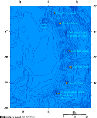
Cook Island is the central and largest island of the Southern Thule island group, part of the South Sandwich Islands in the far south Atlantic Ocean. Southern Thule was discovered by a British expedition under Captain James Cook in 1775. Cook Island was named for Cook by expedition under Fabian Gottlieb von Bellingshausen, which explored the South Sandwich islands in 1819–1820.


Annenkov Island is an island in South Georgia and the South Sandwich Islands, to the west of the main island of South Georgia. The Pickersgill Islands are to its southeast. It is irregularly shaped and 4 miles (6.4 km) long and 650 m (2,130 ft) high, lying 8 miles (13 km) off the south-central coast of South Georgia.
Barff Peninsula is a peninsula forming the east margin of Cumberland East Bay, South Georgia Island. It is 8 miles (13 km) long and extends northwest from Sörling Valley to Barff Point, its farthest extremity. It was probably first seen by the British expedition under James Cook in 1775. The peninsula as a whole takes its name from Barff Point, which was named for Royal Navy Lieutenant A.D. Barff of HMS Sappho, who, assisted by Captain C.A. Larsen, sketched a map of Cumberland Bay in 1906. Barff Point is considered the eastern headland of East Cumberland Bay.
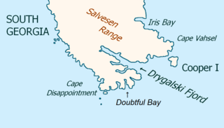
Drygalski Fjord is a bay 1 mile (1.6 km) wide which recedes northwestwards 7 miles (11 km), entered immediately north of Nattriss Head along the southeast coast of South Georgia. It was charted by the Second German Antarctic Expedition, 1911–12, under Wilhelm Filchner, and named for Professor Erich von Drygalski, the leader of the First German Antarctica Expedition, 1901–03.
Wilson Rock is a rock, 183 m high, lying 1.4 nautical miles (2.6 km) west of Bristol Island in the South Sandwich Islands. Discovered by Captain James Cook in 1775, but more accurately charted by Admiral Thaddeus Bellingshausen in 1819–20. Recharted in 1930 by DI personnel on the Discovery II and named for Sir Samuel H. Wilson, Permanent Under-Secretary of State for the British Colonies.
Cook Rock is an arched rock, 45 metres (150 ft) high, lying close east of Trousers Rock and 0.3 nautical miles (0.6 km) northeast of Vindication Island in the South Sandwich Islands. It was charted in 1930 by Discovery Investigations personnel on the Discovery II and named for Captain James Cook.
Mount Darnley is a mountain, 1,100 metres (3,600 ft) high, in the south-central portion of Bristol Island in the South Sandwich Islands off Antarctica. It was charted in 1930 by Discovery Investigations personnel on the Discovery II, who named it for E.R. Darnley.
Fryer Point is the northern point of Bristol Island in the South Sandwich Islands. It was charted in 1930 by Discovery Investigations personnel on the Discovery II and named for Lieutenant Commander D.H. Fryer, Royal Navy, captain of H.M. Surveying Ship Fitzroy.
Grindle Rock is a conspicuous rock, 213 metres (700 ft) high, lying 0.7 nautical miles (1.3 km) west of Bristol Island in the South Sandwich Islands. It was discovered by a British expedition under James Cook in 1775. It was recharted in 1930 by Discovery Investigations personnel on the Discovery II and named by them for Sir Gilbert E.A. Grindle, Permanent Under-Secretary of State for the British Colonies.
Douglas Strait is a strait 2 nautical miles (4 km) wide between Thule Island and Cook Island, in the South Sandwich Islands. The existence of this strait was first noted by a Russian expedition under Fabian Gottlieb von Bellingshausen in 1820. It was charted in 1930 by Discovery Investigations personnel on the Discovery II and named for Vice-Admiral Sir Percy Douglas, a member of the Discovery Committee.
Forsters Passage is a body of water between Bristol Island and Southern Thule in the South Sandwich Islands. In 1775, a British expedition under James Cook gave the name "Forster's Bay", after John R. Forster, a naturalist with the expedition, to what appeared to be a bay in essentially this position. The "bay" was determined to be a strait by a Russian expedition under Fabian Gottlieb von Bellingshausen in 1820.
Hardy Point is the western point of Bellingshausen Island in the South Sandwich Islands. It was charted in 1930 by Discovery Investigations personnel on the Discovery II, who named it for Alister C. Hardy, a member of the zoological staff of the Discovery Committee, 1924–28, and professor of zoology at University College Hull.
Mount Harmer is an ice-covered peak, 1,115 metres (3,660 ft) high, in the north-central portion of Cook Island, in the South Sandwich Islands. It was charted in 1930 by Discovery Investigations personnel on the Discovery II, who named it for Sir Sidney F. Harmer, Vice-Chairman of the Discovery Committee.
Havfruen Peak is a peak in the eastern part of Bristol Island, South Sandwich Islands. It is 365 metres (1,200 ft) high and is conspicuous from both north and south. It was named by the UK Antarctic Place-Names Committee in 1971 after the Norwegian barque Havfruen which was damaged by ice and sank off the South Sandwich Islands on December 1, 1911.
Hueca Point is the westernmost point of Montagu Island in the South Sandwich Islands. The name "Punta Hueca" was first used in Argentine hydrographic publications of 1953.
Herd Point is a point which forms the west side of Ferguson Bay at the south end of Thule Island, in the South Sandwich Islands. It was roughly charted by a Russian expedition under Fabian Gottlieb von Bellingshausen in 1819–20. It was recharted in 1930 by Discovery Investigations personnel on the Discovery II and named for R.D. Herd of Ferguson Brothers, Port Glasgow, Scotland, the builders of the Discovery II.

Twitcher Rock is a rock in the southern part of Douglas Strait, 55 meters high and 140 to 150 meters in diameter, lying 0.7 nautical miles (1.3 km) east of Hewison Point, the southeast point of Thule Island in the South Sandwich Islands. Discovered by a Russian expedition under Fabian Gottlieb von Bellingshausen in 1820, it was charted in 1930 by DI personnel on the British ship Discovery II. They named it for John Montagu, 4th Earl of Sandwich, who was popularly known by the nickname Jemmy Twitcher.
Maurice Channel is a strait 1.5 nautical miles (3 km) wide between Bellingshausen Island and Cook Island, in the South Sandwich Islands off Antarctica. In 1820, Fabian Gottlieb von Bellingshausen indirectly indicated the existence of the strait by describing Southern Thule as consisting of one high rock and three small islands. The strait was charted in 1930 by Discovery Investigations personnel on the Discovery II and named for Henry Gascoyne Maurice, a member of the Discovery Committee.
References
- ↑ "Freezland Rock". Geographic Names Information System . United States Geological Survey, United States Department of the Interior . Retrieved 9 April 2012.
- ↑ Alberts, Fred G., ed. (June 1995). Geographic Names of the Antarctic (PDF) (second ed.). United States Board on Geographic Names. p. 259. Retrieved 5 April 2012.
![]() This article incorporates public domain material from "Freezland Rock". Geographic Names Information System . United States Geological Survey.
This article incorporates public domain material from "Freezland Rock". Geographic Names Information System . United States Geological Survey.
Capital: King Edward Point | |||||||
| General | |||||||
| Settlements / Whaling stations | |||||||
| South Georgia islands | |||||||
| South Sandwich Islands |
| ||||||
| Seamounts | |||||||
| Landmarks |
| ||||||
| | This South Georgia and the South Sandwich Islands location article is a stub. You can help Wikipedia by expanding it. |