Zavodovski Island

Last updated

Zavodovski Island
Zavodovski Island ISS016.jpg
NASA image of Zavodovski Island
Atlantic Ocean laea location map.svg
Red pog.svg
Zavodovski Island
Location in South Georgia and the South Sandwich Islands.
Geography
Location Southern Ocean
Coordinates 56°18′S27°35′W / 56.30°S 27.58°W / -56.30; -27.58 [1]
Length4 km (2.5 mi)
Width3.8 km (2.36 mi)
Highest elevation551 m (1808 ft)
Highest point Mount Curry
Administration
United Kingdom
Demographics
Populationuninhabited

Zavodovski Island is an uninhabited volcanic island in the Traversay Islands subgroup of the South Sandwich Islands, which are located southeast of South Georgia in the South Atlantic Ocean. It is the northernmost of the South Sandwich Islands and consists of one major stratovolcano, Mount Curry, which is surrounded to the east by a plain formed by lava flows. Mount Curry has a fumarolically active crater on the southwestern side, which also bears traces of a sector collapse. An eruption occurred in 2016.

Contents

The island was officially discovered in December 1819 by Thaddeus von Bellingshausen. The largest penguin colony on Earth with over a million breeding pairs is situated on Zavodovski. It consists mostly of chinstrap penguins, although other seabirds and penguin species breed on the island as well. Early explorers noted the bad smell of the island, which is reflected in numerous placenames.

Geography and geomorphology

Zavodovski is the northernmost of the South Sandwich Islands, which lie southeast of South Georgia [2] in the Southern Atlantic Ocean [3] and extend over a distance of 350 kilometres (220 mi) in north-south direction. [4] Together with Leskov and Visokoi Island, it makes up the Traversay Islands [5] subgroup of the South Sandwich Islands. [2] Politically, South Georgia and the South Sandwich Islands make up the UK Overseas Territory of South Georgia and the South Sandwich Islands. In 2012, a marine protected area was established in the South Sandwich Islands. The scope of the protected area was further expanded in 2019. [6] Icebergs occur in the surrounding waters, [7] and sea ice reaches Zavodovski in August and September. [8]

The island has dimensions of 3.8 by 4.0 kilometres (2.4 mi × 2.5 mi) [9] and a diamond-shaped outline, with northern Reek Point, eastern Pungent Point, southern Fume Point and western Stench Point. Two embayments are located north and northeast of Stench Point between the headlands of Acrid Point and Pacific Point. [1] The coastlines are made up by 15–30 metres (49–98 ft) high cliffs, rock shelves and boulder beaches. [10] Slightly west of the centre of the island lies the 551 metres (1,808 ft) [11] [1] or 557 metres (1,827 ft) high Mount Curry stratovolcano, also known as Mount Asphyxia. [12] A volcanic crater lies on the southwestern flank, [1] and a further buried crater may exist northwest of the summit. [13] Two fumarolically active fissures extend eastward from Mount Curry to two parasitic vents. [14]

The small size of the island prevents extensive glaciation; there are only thin glaciers and snow fields [15] (in 1962, ice area was about 0.1 square kilometres (0.04 sq mi) [16] ) and ice is often ash-covered. [17] Except on the western side, where marine erosion has eroded away parts of the island, lava flows surround most of Mount Curry. [1] On the eastern side of the island, they form a gently undulating plain that is easily traversable [18] and accessible from the sea, by humans and penguins alike. [9] This asymmetry is probably due to the preferential emission of lava flows on the eastern side. [19] Lava flows feature columnar joints that are visible in coastal cliffs. [20] On the western side, cliffs show traces of a sector collapse, which extended below sea level [21] and left a 4 cubic kilometres (0.96 cu mi) deposit on the seafloor. [22]

A 6 kilometres (3.7 mi) wide submarine shelf surrounds Zavodovski at a depth of 70–160 metres (230–520 ft) on all sides except the western, where it has been removed by the sector collapse. [21] The shelf probably formed through marine erosion during glacial sea level decrease. [23] The island lies on the western one of a pair of submarine ridges, which have a width of 54 kilometres (34 mi) at 1,800 metres (5,900 ft) depth [21] and form an edifice with a total volume of about 5,400 cubic kilometres (1,300 cu mi). [24] Their margins are cut by chutes and slump scars; the bathymetry is irregular. [25] Protector Shoal is 56 kilometres (35 mi) northwest of Zavodovski, and connected with it by a submarine ridge at less than 1 kilometre (0.62 mi) depth. [26] In 1962, a submarine eruption produced a pumice raft that reached New Zealand. [27] Another, deeper, submarine ridge connects Zavodovski to Leskov Island to the southwest. [28]

Geology

East of the South Sandwich Islands, the South America Plate subducts beneath the Scotia Plate at a rate of 70 millimetres per year (2.8 in/year). The subduction is responsible for the existence of the South Sandwich island arc, which is constituted by about eleven islands [4] in an eastward curving chain, [29] and submarine volcanoes such as Protector in the north and Adventure and Kemp in the south. [30] From north to south Zavodovski, Leskov Island, Visokoi Island, Candlemas Island-Vindication Island, Saunders Island, Montagu Island, Bristol Island-Freezland Rock, Bellingshausen Island, Cook Island-Thule Island emerge from the sea. Most of the islands are stratovolcanoes of various sizes. [26]

Composition

Basalt is the dominant rock produced by volcanic activity [31] [21] and defines a potassium-poor tholeiitic suite. [32] Phenocrysts include augite, clinopyroxene, olivine and plagioclase. [33] Compositional patterns at Zavodovski and Protector Shoal resemble those of Candlemas Island. [34] Intense weathering gives the rocks yellow and red colours. [20]

Flora and fauna

Mosses grow on Zavodovski, and algae in proximity to penguin colonies. [19] Unlike other islands in the South Sandwich Islands, vegetation is rare even around fumaroles. [35] It consists of bryophytes. [36] Arthropods include mites. [37]

Zavodovski has the largest population of breeding penguins on Earth. [38] 600,0001,000,000 chinstrap penguins breed on Zavodovski, [39] making up about one quarter of the global population of this species [40] and possibly one of the largest bird colonies in the world. [41] The colony is large enough to cause substantial ammonia emissions in the region. [42] Other penguin species breeding on Zavodovski include more than 50,000 macaroni penguins [39] which form small colonies within chinstrap penguin colonies, [43] and gentoo penguins. The size of the penguin colony on Zavodovski appears to be increasing. [44] King penguins also visit the island [45] and may breed there. [41] [43] Other seabirds breeding on Zavodovski include Antarctic fulmars, Antarctic terns, black-bellied storm petrels, blue-eyed shags, cape petrels, kelp gulls, snow petrels, southern giant petrels and Wilson's storm petrels. [39] [46] Antarctic fur seal colonies occur along the coasts. [47]

Geologic history

Zavodovski has erupted during the Holocene, [31] though its rocks have not been radiometrically dated. Alternating sequences of lava flows and tephra built the island up during the last few tens of thousands of years, and were more recently buried by ash fallout. [33] The eastern submarine ridge is covered by sediment and appears to be older, indicating that volcanism has moved westward over time. [48] If glaciers developed on Zavodovski during the last glacial maximum, the steep submarine slopes would have restricted their expansion. [49]

The island is one of the most active volcanoes in the South Sandwich Islands. [50] It was reported to be smoking by von Bellingshausen, who observed emissions from the crater and noted a smell of sulfur, [51] and there are frequent reports of steam emission. [9] Reports of eruptions in 1823, 1830 and 1908 may refer to fumarolic activity. [52] In 1830 fresh lava and floating pumices were reported from the eastern side, [19] and a ship reported an eruption column in 1970. [9] In March 2016, an eruption produced a volcanic cloud and fallout of ash and lava bombs, covering parts of the island and leading the government of South Georgia to issue a navigation warning. [53] Reported inconsistencies of the height of Mount Curry may indicate volcanic activity that changed the summit elevation of the volcano. [15] Undamaged penguin bodies buried by volcanic ash have been found, [54] and activity may have obliterated breeding seabird colonies. [55]

Fumarolic activity occurs in the southwestern crater and extends to the cliffs on the sea, south of Acrid Point. [56] The fumarolic vents have deposited sulfur in the crater. [20] There are conflicting reports of emissions on the eastern and southern side of Zavodovski. [19] Volcanic heat is visible from satellite images, [9] and keeps certain parts of the island snow-free. [56] Emissions from Mount Curry alter the properties of clouds in the area, making them brighter. [57]

Research history and naming

Seal hunters may have visited Zavodovski and the other Traversay Islands before 1819. [58] The official discovery was by Thaddeus von Bellingshausen in December 1819. He sent a landing party ashore and named the island after the captain-lieutenant of his ship Vostok. [5] The correct transliteration would be Zavadovskiy, but the older transliteration Zavadovski is the common one. [59] The Traversay Islands were named after Marquis de Traversay who sponsored the Bellingshausen expedition. [59] Other names of the island are Zawadowski, Ssawadowski, Sawadowsky and Prince Island. [60]

The South Sandwich Islands probably are not visited more frequently than a few times per year. Initially, sealers came to the islands, while whalers hunted in the surrounding seas. Scientific expeditions took place in 1930 and 1962. [26] Zavodovski is probably the most frequently visited of the South Sandwich Islands, [33] with cruise ships approaching to view the penguin colonies [61] and tourist boats landing. [62]

The South Sandwich Islands are uninhabited and remote; South Georgia is the closest inhabited place 250 kilometres (160 mi) northwest from Zavodovski. [26] Argentina installed the Guardiamarina Lamas beacon on Zavodovski; [63] presently, an unmanned weather station on the island is operated by South Africa. [62] Politically, South Georgia and the South Sandwich Islands make up the UK Overseas Territory of South Georgia and the South Sandwich Islands. In 2012, a marine protected area was established in the South Sandwich Islands. The scope of the protected area was further expanded in 2019. [6] Argentina had laid claim to the islands in 1957, in reaction to a Soviet landing on Zavodovski. [64]

Smell

Early discoverers remarked on the intense smell of the island, [65] which has been referred to as "the world's smelliest", [66] and numerous placenames on Zavodovski reference the smells and noxious fumes: Acrid Point, Fume Point, Noxious Bluff, Pungent Point, Reek Point and Stench Point. [lower-alpha 1] Von Bellingshausen attributed it to penguin droppings, which forced his landing party to leave the island. [5] Noxious fumes also originate from the fumaroles. [19] The same odour may have poisoned Carl Anton Larsen during his 1908 visit [73] and forced him off the island. [74] Later reports noticed it as far as several miles offshore. [19]

Notes

Related Research Articles

<span class="mw-page-title-main">South Sandwich Islands</span> Island chain in South Atlantic Ocean

The South Sandwich Islands are a chain of uninhabited volcanic islands in the South Atlantic Ocean. They are administered as part of the British Overseas Territory of South Georgia and the South Sandwich Islands. The chain lies in the sub-Antarctic region, about 700 kilometres (430 mi) southeast of South Georgia and 1,700 kilometres (1,100 mi) northeast from the tip of the Antarctic Peninsula.

<span class="mw-page-title-main">Vindication Island</span> Island in the South Sandwich Islands

Vindication Island is a small uninhabited island of the Candlemas Islands in the South Sandwich Islands. It is one of about a dozen islands that make up the South Sandwich island arc, a chain of volcanoes in the Southern Ocean that was discovered in 1775 by James Cook. The volcanism is caused by the subduction of the South American Plate beneath the Sandwich Plate.

<span class="mw-page-title-main">Cook Island, South Sandwich Islands</span> Island in the Southern Thule group of the South Sandwich Islands

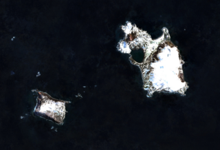
Cook Island is the central and largest island of the Southern Thule island group, part of the South Sandwich Islands in the far south Atlantic Ocean. Southern Thule was discovered by a British expedition under Captain James Cook in 1775. Cook Island was named for Cook by a Russian expedition under Fabian Gottlieb von Bellingshausen, which explored the South Sandwich islands in 1819–1820.

<span class="mw-page-title-main">Mount Hampton</span> Shield volcano in Antarctica

Mount Hampton is a shield volcano with a circular ice-filled caldera. It is a twin volcano with Whitney Peak to the northwest and has erupted phonolite rocks. It is the northernmost of the volcanoes which comprise the Executive Committee Range in Marie Byrd Land, Antarctica and was active during the Miocene.

<span class="mw-page-title-main">Mount Melbourne</span> Stratovolcano in the Antarctic

Mount Melbourne is a 2,733-metre-high (8,967 ft) ice-covered stratovolcano in Victoria Land, Antarctica, between Wood Bay and Terra Nova Bay. It is an elongated mountain with a summit caldera filled with ice with numerous parasitic vents; a volcanic field surrounds the edifice. Mount Melbourne has a volume of about 180 cubic kilometres (43 cu mi) and consists of tephra deposits and lava flows; tephra deposits are also found encased within ice and have been used to date the last eruption of Mount Melbourne to 1892 ± 30 years. The volcano is fumarolically active.

<span class="mw-page-title-main">Mount Takahe</span> Shield volcano in the Antarctic continent

Mount Takahe is a 3,460-metre-high (11,350 ft) snow-covered shield volcano in Marie Byrd Land, Antarctica, 200 kilometres (120 mi) from the Amundsen Sea. It is a c. 30-kilometre-wide (19 mi) mountain with parasitic vents and a caldera up to 8 kilometres (5 mi) wide. Most of the volcano is formed by trachytic lava flows, but hyaloclastite is also found. Snow, ice, and glaciers cover most of Mount Takahe. With a volume of 780 km3 (200 cu mi), it is a massive volcano; the parts of the edifice that are buried underneath the West Antarctic Ice Sheet are probably even larger. It is part of the West Antarctic Rift System along with eighteen other known volcanoes.

<span class="mw-page-title-main">Bridgeman Island (South Shetland Islands)</span> Island in Antarctica

Bridgeman Island is one of the South Shetland Islands in Antarctica. It is an almost circular, volcanic island marked by steep sides, measuring 900 by 600 metres with a maximum elevation of 240 m (787 ft) high, lying 45 kilometres (28 mi) east of King George Island.

<span class="mw-page-title-main">Traversay Islands</span> Three northernmost South Sandwich Islands

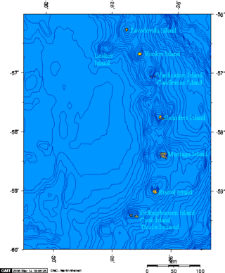
The Traversay Islands are a group of three islands—Zavodovski, Leskov and Visokoi—at the northern end of the South Sandwich Islands.

<span class="mw-page-title-main">Protector Shoal</span> Submarine volcano NW of Zavodovski Island in the South Sandwich Islands

Protector Shoal is the shallowest point of the Protector Seamounts, a group of submarine volcanoes in the Southern Ocean. They are part of the South Sandwich island arc, a volcanic arc that has given rise to the South Sandwich Islands. Protector Shoal reaches a depth of 55 metres (180 ft) below sea level and is part of a larger group of seamounts that formed atop a larger ridge. Some of these seamounts bear traces of sector collapses, and one is capped by nested calderas.

<span class="mw-page-title-main">Lastarria</span> Stratovolcano on the border between Chile and Argentina

Lastarria is a 5,697 metres (18,691 ft) high stratovolcano that lies on the border between Chile and Argentina. It is remote, and the surroundings are uninhabited but can be reached through an unpaved road. The volcano is part of the Central Volcanic Zone, one of the four segments of the volcanic arc of the Andes. Over a thousand volcanoes—of which about 50 are active—lie in this over 1,500 kilometres (930 mi) long chain of volcanoes, which is generated by subduction of the Nazca Plate beneath the South American Plate.

<span class="mw-page-title-main">Mount Berlin</span> Volcano in West Antarctica

Mount Berlin is a glacier-covered volcano in Marie Byrd Land, Antarctica, 100 kilometres (62 mi) from the Amundsen Sea. It is a roughly 20-kilometre-wide (12 mi) mountain with parasitic vents that consists of two coalesced volcanoes: Berlin proper with the 2-kilometre-wide (1.2 mi) Berlin Crater and Merrem Peak with a 2.5-by-1-kilometre-wide crater, 3.5 kilometres (2.2 mi) away from Berlin. The summit of the volcano is 3,478 metres (11,411 ft) above sea level. It has a volume of 200 cubic kilometres (48 cu mi) and rises from the West Antarctic Ice Sheet. It is part of the Marie Byrd Land Volcanic Province. Trachyte is the dominant volcanic rock and occurs in the form of lava flows and pyroclastic rocks.

Kemp Caldera and Kemp Seamount form a submarine volcano south of the South Sandwich Islands, in a region where several seamounts are located. The seamount rises to a depth of 80 metres (260 ft) below sea level; the caldera has a diameter of 8.3 by 6.5 kilometres and reaches a depth of 1,600 metres (5,200 ft). The caldera contains several Hydrothermal vents, including white smokers and diffuse venting areas, which are host to chemolithotrophic ecological communities. The seamount and caldera, which were discovered by seafloor mapping in 2009, are part of the South Georgia and the South Sandwich Islands Marine Protected Area.

<span class="mw-page-title-main">Leskov Island</span> Island in the South Sandwich Islands

Leskov Island is an island in the South Sandwich Islands named after Russian sailor Arcady Leskov. It is a semicircular 190 metres (620 ft) high eroded volcano with a large bay on its eastern side. Leskov Island is almost entirely surrounded by cliffs and has a surface area of 0.55 by 0.93 kilometres. Volcanic rocks form tuffs and lava and consist almost entirely of andesite.

<span class="mw-page-title-main">Hudson Mountains</span> Mountain range in Antarctica

The Hudson Mountains are a mountain range in western Ellsworth Land just east of Pine Island Bay at the Walgreen Coast of the Amundsen Sea. They are of volcanic origin, consisting of low scattered mountains and nunataks that protrude through the West Antarctic Ice Sheet. The Hudson Mountains are bounded on the north by Cosgrove Ice Shelf and on the south by Pine Island Glacier. The mountains were volcanically active during the Miocene and Pliocene, but there is evidence for an eruption about two millennia ago and uncertain indications of activity in the 20th century.

<span class="mw-page-title-main">Saunders Island, South Sandwich Islands</span> British island in the southern Atlantic

Saunders Island is a crescent-shaped island 8.5 by 5 kilometres long, lying between Candlemas Island and Montagu Island in the South Sandwich Islands, a British Overseas Territory in the southern Atlantic Ocean. It is a volcanic island composed of an active stratovolcano, 990-metre (3,248 ft) Mount Michael, and a cluster of pyroclastic cones on the southeastern side. Mount Michael has a lava lake in its summit crater, which is fumarolically active, and there is widespread evidence of recent eruptions across the island.

<span class="mw-page-title-main">Southern Thule</span> Island group in the South Sandwich Islands

Southern Thule is a group of the three southernmost islands in the South Sandwich Islands in the southern Atlantic Ocean: Bellingshausen, Cook, and Thule (Morrell). It is a largely submerged volcano of which only the three islands emerge above sea level. Between Cook and Thule, and south of Bellingshausen, lie two submerged calderas; a third caldera is located on Thule. Cook Island is inactive and largely glaciated, while Bellingshausen and Thule feature active craters with fumarolic activity, and there is evidence of eruptions in the 20th century.

<span class="mw-page-title-main">Candlemas Island</span> Island of the Candlemas Islands in the South Sandwich Islands

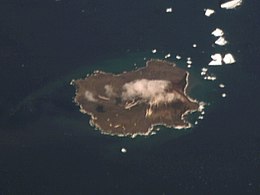
Candlemas Island is a small uninhabited island of the Candlemas Islands in the South Sandwich Islands. It is one of about a dozen islands that make up the South Sandwich island arc, a chain of volcanoes in the Southern Ocean that was discovered in 1775 by James Cook. The volcanism is caused by the subduction of the South American Plate beneath the Sandwich Plate. The island is remote and rarely visited due to the often hostile weather conditions, but is populated by penguins and seabirds, which form large breeding colonies.

<span class="mw-page-title-main">Visokoi Island</span> Uninhabited island in the South Sandwich Islands

Visokoi Island is an uninhabited volcanic island in the Traversay Islands subgroup of the South Sandwich Islands, which are located southeast of South Georgia. It consists of one major volcano, Mount Hodson whose height is usually given as 1,005 metres (3,297 ft). The mountain is mostly covered by glaciers, except for several low areas on the coast like the northern Finger Point and eastern Irving Point. Several parasitic vents are found especially on the eastern side, and one vent close to Finger Point is still hot. Eruptions were reported in 1830, 1927 and 1930.

<span class="mw-page-title-main">Montagu Island</span> Largest of the South Sandwich Islands

Montagu Island is the largest of the South Sandwich Islands, located in the Scotia Sea off the coast of Antarctica. It is almost entirely ice-covered with only sparse rocky outcrops, and consists of a large caldera with a large parasitic cone, Mount Oceanite. Several secondary volcanic cones have formed in the caldera, including Mount Belinda.

<span class="mw-page-title-main">Bristol Island</span> Island in the South Sandwich Islands

Bristol Island is an uninhabited island in the South Sandwich Islands. The island is almost entirely surrounded by ice cliffs and largely covered with ice. It features both the oldest rocks of this archipelago and an active volcano that last erupted in 2016.

References

  1. 1 2 3 4 5 LeMasurier et al. 1990, p. 368.
  2. 1 2 Barr 2000, p. 318.
  3. Lynch et al. 2016, p. 1615.
  4. 1 2 LeMasurier et al. 1990, p. 361.
  5. 1 2 3 Barr 2000, p. 317.
  6. 1 2 Liu et al. 2020, p. 3.
  7. Wild 1923, p. 84.
  8. Thorpe & Murphy 2022, p. 6.
  9. 1 2 3 4 5 Patrick & Smellie 2013, p. 484.
  10. Holdgate & Baker 1979, p. 14.
  11. GVP 2023, General Information.
  12. Liu et al. 2020, p. 6.
  13. Patrick & Smellie 2013, p. 483.
  14. LeMasurier et al. 1990, pp. 368, 369.
  15. 1 2 Holdgate & Baker 1979, p. 16.
  16. Kargel et al. 2014, p. 773.
  17. Convey et al. 2000, p. 1281.
  18. Holdgate & Baker 1979, p. 15.
  19. 1 2 3 4 5 6 Holdgate & Baker 1979, p. 17.
  20. 1 2 3 Liu et al. 2020, p. 7.
  21. 1 2 3 4 Leat et al. 2010, p. 114.
  22. Leat et al. 2010, p. 123.
  23. Leat et al. 2010, p. 122.
  24. Leat et al. 2010, p. 121.
  25. Leat et al. 2010, p. 116.
  26. 1 2 3 4 LeMasurier et al. 1990, p. 362.
  27. Coombs & Landis 1966, p. 289.
  28. LeMasurier et al. 1990, pp. 361, 362.
  29. Holdgate & Baker 1979, p. 3.
  30. Leat et al. 2010, p. 111.
  31. 1 2 LeMasurier et al. 1990, p. 363.
  32. Pearce et al. 1995, p. 1077.
  33. 1 2 3 LeMasurier et al. 1990, p. 369.
  34. LeMasurier et al. 1990, pp. 364, 365.
  35. Convey et al. 2000, p. 1287.
  36. Convey et al. 2000, p. 1292.
  37. Convey, Greenslade & Pugh 2000, p. 602.
  38. Liu et al. 2020, p. 8.
  39. 1 2 3 Hart & Convey 2018, Table 3.
  40. Convey, Morton & Poncet 1999, p. 114.
  41. 1 2 Hart & Convey 2018, p. 26.
  42. Blackall et al. 2007, p. 4.
  43. 1 2 Lynch et al. 2016, p. 1620.
  44. Lynch et al. 2016, p. 1622.
  45. Convey, Morton & Poncet 1999, p. 113.
  46. Convey, Morton & Poncet 1999, pp. 115–119.
  47. Convey, Morton & Poncet 1999, p. 120.
  48. Leat et al. 2010, p. 117.
  49. Hodgson et al. 2014, p. 145.
  50. LeMasurier et al. 1990, p. 365.
  51. Barr 2000, p. 319.
  52. GVP 2023, Eruption history.
  53. GVP 2023, Latest Activity Reports.
  54. Convey, Morton & Poncet 1999, p. 121.
  55. Convey, Morton & Poncet 1999, p. 123.
  56. 1 2 Holdgate & Baker 1979, pp. 15, 16.
  57. Schmidt et al. 2012, p. 7322.
  58. Hart & Convey 2018, p. 20.
  59. 1 2 Barr 2000, p. 322.
  60. GVP 2023, Synonyms & Subfeatures.
  61. Convey, Morton & Poncet 1999, p. 108.
  62. 1 2 Hart & Convey 2018, p. 21.
  63. Yamin & Anselmi 2020, p. 15.
  64. Bologna 1982, p. 50.
  65. Kemp & Nelson 1931, p. 160.
  66. Estok 2018, p. 4.
  67. GNIS 2023a.
  68. GNIS 2023b.
  69. GNIS 2023c.
  70. GNIS 2023d.
  71. GNIS 2023e.
  72. GNIS 2023f.
  73. Holdgate & Baker 1979, p. 5.
  74. Kemp & Nelson 1931, p. 2.

Sources

Further reading