South Georgia and the South Sandwich Islands (SGSSI) is a British Overseas Territory in the southern Atlantic Ocean. It is a remote and inhospitable collection of islands, consisting of South Georgia and a chain of smaller islands known as the South Sandwich Islands. South Georgia is 165 kilometres (103 mi) long and 35 kilometres (22 mi) wide and is by far the largest island in the territory. The South Sandwich Islands lie about 700 kilometres (430 mi) southeast of South Georgia. The territory's total land area is 3,903 km2 (1,507 sq mi). The Falkland Islands are about 1,300 kilometres (810 mi) west from its nearest point.

Signy Island is a small subantarctic island in the South Orkney Islands of Antarctica. It was named by the Norwegian whaler Petter Sørlle (1884–1933) after his wife, Signy Therese.

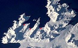
Fortuna Glacier is a tidewater glacier at the mouth of Cumberland Bay on the island of South Georgia. It flows in a northeast direction to its terminus just west of Cape Best, with an eastern distributary almost reaching the west side of Fortuna Bay, on the north coast of South Georgia. It was named in about 1912, presumably after the whale catcher Fortuna, and is notable for two major events in the 20th century.

Adelaide Island is a large, mainly ice-covered island, 139 kilometres (75 nmi) long and 37 kilometres (20 nmi) wide, lying at the north side of Marguerite Bay off the west coast of the Antarctic Peninsula. The Ginger Islands lie off the southern end. Mount Bodys is the easternmost mountain on Adelaide Island, rising to over 1,220 m. The island lies within the Argentine, British and Chilean Antarctic claims.
Trinity Island or Île de la Trinité or Isla Trinidad is an island 24 km (15 mi) long and 10 km (6 mi) wide in the northern part of the Palmer Archipelago, Antarctica. It lies 37 km (23 mi) east of Hoseason Island, 72.6 km (45 mi) south of Deception Island in the South Shetland Islands, and 10.3 km (6 mi) north-northwest of Cape Andreas on the Antarctic Peninsula. The island was named by Otto Nordenskiöld, leader of the 1901-1904 Swedish Antarctic Expedition (SAE) in commemoration of Edward Bransfield's "Trinity Land" of 1820.
The Trojan Range is a mountain range rising to 2,760 metres (9,055 ft), extending northward from Mount Francais along the east side of Iliad Glacier, Anvers Island, in the Palmer Archipelago of the British Antarctic Territory. It was surveyed by the Falkland Islands Dependencies Survey (FIDS) in 1955 and named by the UK Antarctic Place-Names Committee (UK-APC) for the Trojans, one of the opposing sides in the Trojan War in Homer's Iliad.

Operation Paraquet was the code name for the British military operation to recapture the island of South Georgia from Argentine military control in April 1982 at the start of the Falklands War.

James William Slessor Marr was a Scottish marine biologist and polar explorer. He was leader of the World War 2 British Antarctic Expedition Operation Tabarin during its first year, 1943–1945.

Arrowsmith Peninsula is a cape about 40 miles (64 km) long on the west coast of Graham Land, west of Forel Glacier, Sharp Glacier and Lallemand Fjord, and northwest of Bourgeois Fjord, with Hanusse Bay lying to the northwest. It was surveyed by the Falkland Islands Dependencies Survey (FIDS) in 1955-58 and named for Edwin Porter Arrowsmith, Governor of the Falkland Islands.

Thatcher Peninsula is a mountainous peninsula in north-central South Georgia. Its total area is approximately 5,640 hectares, with roughly 1,620 ha covered in vegetation. It terminates to the north in Mai Point, rising between Cumberland West Bay to the west, and Cumberland East Bay and Moraine Fjord to the east. It is bounded to the southwest and south by Lyell Glacier and Hamberg Glacier. King Edward Cove on the east side of the peninsula is the site of the British Antarctic Survey (BAS) Grytviken station and the disused whaling station of the same name.

Cumberland East Bay is a bay forming the eastern arm of Cumberland Bay, South Georgia. It is entered between Sappho Point on Thatcher Peninsula and Barff Point on Barff Peninsula. It is nearly 3 miles (4.8 km) wide, and extends 8 miles (13 km) in a southeast direction.

Busen Point or Busen Peninsula is a headland forming the southeast side of the entrance to Stromness Bay, on the north coast of South Georgia island. It lies on the Lewin Peninsula in between Stromness Bay and Cumberland West Bay.
Emperor Island is a small island in Marguerite Bay, lying close north-east of the Courtier Islands in the Dion Islands. The islands in this group were discovered and roughly charted in 1909 by the French Antarctic Expedition. This island was surveyed in 1948 by the Falkland Islands Dependencies Survey and so named by the UK Antarctic Place-Names Committee because a low rock and shingle isthmus at the south-eastern end of the island was the winter breeding site of emperor penguins.
Laws Glacier is a confluent glacier system which flows into Marshall Bay on the south coast of Coronation Island, in the South Orkney Islands off Antarctica. It was surveyed in 1948–49 by the Falkland Islands Dependencies Survey (FIDS), and was named by the UK Antarctic Place-Names Committee for Richard M. Laws of the FIDS, leader and biologist at Signy Research Station in 1948 and 1949, and at South Georgia in 1951.

Andrew Glacier is a glacier 3 nautical miles (6 km) long, flowing northeast into Ognen Cove in Charcot Bay immediately west of the Webster Peaks on Trinity Peninsula, northern Graham Land.

Bagshawe Glacier is a glacier which drains the northeast slopes of Mount Theodore and discharges into Lester Cove, Andvord Bay west of Mount Tsotsorkov, on the west coast of Graham Land, Antarctica.

Coulter Glacier is a steeply inclined glacier, 5 nautical miles (9 km) long, flowing south from the Havre Mountains, northern Alexander Island, into Kolokita Cove in Lazarev Bay, Antarctica. The glacier was photographed from the air by the Ronne Antarctic Research Expedition in 1947 and mapped from the photographs by the Falkland Islands Dependencies Survey in 1960. It was named by the Advisory Committee on Antarctic Names for R.W. Coulter, Master of USNS Alatna during U.S. Navy Operation Deepfreeze, 1969.
Portal Point is a narrow point in the northeast part of Reclus Peninsula, on the west coast of Graham Land. In 1956, a Falkland Islands Dependencies Survey (FIDS) hut was established on the point, from which a route to the plateau was established. So named by the United Kingdom Antarctic Place-Names Committee (UK-APC) in 1960 because the point is the "gateway" of the route.

Lynch Island is an island lying in the eastern part of Marshall Bay, close off the south coast of Coronation Island in the South Orkney Islands, Antarctica.

Thomas James Turtle BEM, known as Touché or Tommy Turtle, was a British Army soldier originally from Ireland who took part in many special forces campaigns, including the Falklands War and the Bosnian War.