
Mars Global Surveyor (MGS) was an American robotic space probe developed by NASA's Jet Propulsion Laboratory and launched November 1996. MGS was a global mapping mission that examined the entire planet, from the ionosphere down through the atmosphere to the surface. As part of the larger Mars Exploration Program, Mars Global Surveyor performed atmospheric monitoring for sister orbiters during aerobraking, and helped Mars rovers and lander missions by identifying potential landing sites and relaying surface telemetry.

Malin Space Science Systems (MSSS) is a San Diego, California-based private technology company that designs, develops, and operates instruments and technical equipment to fly on uncrewed spacecraft. MSSS is headed by chief scientist and CEO Michael C. Malin.

The Memnonia quadrangle is one of a series of 30 quadrangle maps of Mars used by the United States Geological Survey (USGS) Astrogeology Research Program. The Memnonia quadrangle is also referred to as MC-16.

Newton is a large crater on Mars, with a diameter close to 300 km. It is located south of the planet's equator in the heavily cratered highlands of Terra Sirenum in the Phaethontis quadrangle. The crater was named in 1973 by the International Astronomical Union (IAU) Working Group for Planetary System Nomenclature (WGPSN) in honor of British physicist Sir Isaac Newton.
Acidalia Planitia is a plain on Mars, between the Tharsis volcanic province and Arabia Terra to the north of Valles Marineris, centered at 49.8°N 339.3°E. Most of this region is found in the Mare Acidalium quadrangle, but a small part is in the Ismenius Lacus quadrangle. The plain contains the famous Cydonia region at the contact with the heavily cratered highland terrain.
Extraterrestrial liquid water is water in its liquid state that naturally occurs outside Earth. It is a subject of wide interest because it is recognized as one of the key prerequisites for life as we know it and is thus surmised to be essential for extraterrestrial life.
Becquerel is a 167 km-diameter crater at 22.1°N, 352.0°E on Mars, in Arabia Terra in Oxia Palus quadrangle. It is named after Antoine H. Becquerel.

Mars is the fourth planet from the Sun. The surface of Mars is orange-red because it is covered in iron(III) oxide dust, giving it the nickname "the Red Planet". Mars is among the brightest objects in Earth's sky, and its high-contrast albedo features have made it a common subject for telescope viewing. It is classified as a terrestrial planet and is the second smallest of the Solar System's planets with a diameter of 6,779 km (4,212 mi). In terms of orbital motion, a Martian solar day (sol) is equal to 24.5 hours, and a Martian solar year is equal to 1.88 Earth years. Mars has two natural satellites that are small and irregular in shape: Phobos and Deimos.

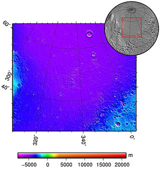
The Arcadia quadrangle is one of a series of 30 quadrangle maps of Mars used by the United States Geological Survey (USGS) Astrogeology Research Program. The quadrangle is located in the north-central portion of Mars’ western hemisphere and covers 240° to 300° east longitude and 30° to 65° north latitude. The quadrangle uses a Lambert conformal conic projection at a nominal scale of 1:5,000,000 (1:5M). The Arcadia quadrangle is also referred to as MC-3. The name comes from a mountainous region in southern Greece. It was adopted by IAU, in 1958.

The Syrtis Major quadrangle is one of a series of 30 quadrangle maps of Mars used by the United States Geological Survey (USGS) Astrogeology Research Program. The Syrtis Major quadrangle is also referred to as MC-13.
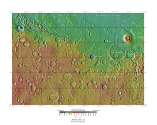
The Aeolis quadrangle is one of a series of 30 quadrangle maps of Mars used by the United States Geological Survey (USGS) Astrogeology Research Program. The Aeolis quadrangle is also referred to as MC-23 . The Aeolis quadrangle covers 180° to 225° W and 0° to 30° south on Mars, and contains parts of the regions Elysium Planitia and Terra Cimmeria. A small part of the Medusae Fossae Formation lies in this quadrangle.

Almost all water on Mars today exists as ice, though it also exists in small quantities as vapor in the atmosphere. What was thought to be low-volume liquid brines in shallow Martian soil, also called recurrent slope lineae, may be grains of flowing sand and dust slipping downhill to make dark streaks. While most water ice is buried, it is exposed at the surface across several locations on Mars. In the mid-latitudes, it is exposed by impact craters, steep scarps and gullies. Additionally, water ice is also visible at the surface at the north polar ice cap. Abundant water ice is also present beneath the permanent carbon dioxide ice cap at the Martian south pole. More than 5 million km3 of ice have been detected at or near the surface of Mars, enough to cover the whole planet to a depth of 35 meters (115 ft). Even more ice might be locked away in the deep subsurface. Some liquid water may occur transiently on the Martian surface today, but limited to traces of dissolved moisture from the atmosphere and thin films, which are challenging environments for known life. No evidence of present-day liquid water has been discovered on the planet's surface because under typical Martian conditions, warming water ice on the Martian surface would sublime at rates of up to 4 meters per year. Before about 3.8 billion years ago, Mars may have had a denser atmosphere and higher surface temperatures, potentially allowing greater amounts of liquid water on the surface, possibly including a large ocean that may have covered one-third of the planet. Water has also apparently flowed across the surface for short periods at various intervals more recently in Mars' history. Aeolis Palus in Gale Crater, explored by the Curiosity rover, is the geological remains of an ancient freshwater lake that could have been a hospitable environment for microbial life. The present-day inventory of water on Mars can be estimated from spacecraft images, remote sensing techniques, and surface investigations from landers and rovers. Geologic evidence of past water includes enormous outflow channels carved by floods, ancient river valley networks, deltas, and lakebeds; and the detection of rocks and minerals on the surface that could only have formed in liquid water. Numerous geomorphic features suggest the presence of ground ice (permafrost) and the movement of ice in glaciers, both in the recent past and present. Gullies and slope lineae along cliffs and crater walls suggest that flowing water continues to shape the surface of Mars, although to a far lesser degree than in the ancient past.
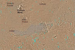
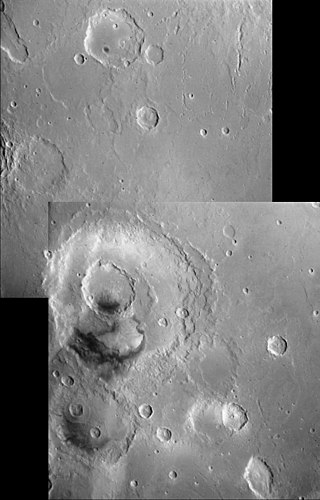
The Elysium Fossae are a group of large troughs in the Elysium quadrangle of Mars at 24.8° north latitude and 213.7° west longitude. They are about 1,175 km long and are named after a classical albedo feature name.

Dark slope streaks are narrow, avalanche-like features common on dust-covered slopes in the equatorial regions of Mars. They form in relatively steep terrain, such as along escarpments and crater walls. Although first recognized in Viking Orbiter images from the late 1970s, dark slope streaks were not studied in detail until higher-resolution images from the Mars Global Surveyor (MGS) and Mars Reconnaissance Orbiter (MRO) spacecraft became available in the late 1990s and 2000s.
Penticton is an impact crater in the Hellas quadrangle of Mars, located at 38.35° south latitude and 263.35° west longitude. Penticton is on the eastern rim of the Hellas impact crater. It is 8 kilometers in diameter and was named after Penticton, a Town in British Columbia, Canada, nearby the little town of Okanagan Falls where is located the Dominion Radio Astrophysical Observatory. Images with HiRISE show gullies which were once thought to be caused by flowing water.

Arandas is a crater in the Mare Acidalium quadrangle of Mars, located 42.77° North and 15.17° West. It is 24.76 km (15.39 mi) in diameter and is named after the town of Arandas in Mexico.
Mars may contain ores that would be very useful to potential colonists. The abundance of volcanic features together with widespread cratering are strong evidence for a variety of ores. While nothing may be found on Mars that would justify the high cost of transport to Earth, the more ores that future colonists can obtain from Mars, the easier it would be to build colonies there.
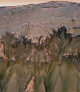
Seasonal flows on warm Martian slopes are thought to be salty water flows occurring during the warmest months on Mars, or alternatively, dry grains that "flow" downslope of at least 27 degrees.
To date, interplanetary spacecraft have provided abundant evidence of water on Mars, dating back to the Mariner 9 mission, which arrived at Mars in 1971. This article provides a mission by mission breakdown of the discoveries they have made. For a more comprehensive description of evidence for water on Mars today, and the history of water on that planet, see Water on Mars.

Very is a crater on Mars, located south of the planet's equator in the heavily cratered highlands of Terra Sirenum in the Phaethontis quadrangle at 49.2°S and 177.1°W. It measures approximately 114.81 kilometres (71.34 mi) in diameter. The crater was named after American astronomer Frank Washington Very.
