Holden is a 140 km wide crater situated within the Margaritifer Sinus quadrangle (MC-19) region of the planet Mars, located with the southern highlands. It is named after American astronomer Edward Singleton Holden. It is part of the Uzboi-Landon-Morava (ULM) system.

The Memnonia quadrangle is one of a series of 30 quadrangle maps of Mars used by the United States Geological Survey (USGS) Astrogeology Research Program. The Memnonia quadrangle is also referred to as MC-16.

The Compact Reconnaissance Imaging Spectrometer for Mars (CRISM) was a visible-infrared spectrometer aboard the Mars Reconnaissance Orbiter searching for mineralogic indications of past and present water on Mars. The CRISM instrument team comprised scientists from over ten universities and was led by principal investigator Scott Murchie. CRISM was designed, built, and tested by the Johns Hopkins University Applied Physics Laboratory.

Newton is a large crater on Mars, with a diameter close to 300 km. It is located south of the planet's equator in the heavily cratered highlands of Terra Sirenum in the Phaethontis quadrangle. The crater was named in 1973 by the International Astronomical Union (IAU) Working Group for Planetary System Nomenclature (WGPSN) in honor of British physicist Sir Isaac Newton.

The geology of Mars is the scientific study of the surface, crust, and interior of the planet Mars. It emphasizes the composition, structure, history, and physical processes that shape the planet. It is analogous to the field of terrestrial geology. In planetary science, the term geology is used in its broadest sense to mean the study of the solid parts of planets and moons. The term incorporates aspects of geophysics, geochemistry, mineralogy, geodesy, and cartography. A neologism, areology, from the Greek word Arēs (Mars), sometimes appears as a synonym for Mars's geology in the popular media and works of science fiction. The term areology is also used by the Areological Society.

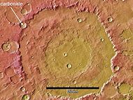
Evidence for carbonates on Mars was first discovered in 2008. Carbonates were formed in the early history of Mars. Evidence shows Mars was once warmer and wet about 4 billion years ago, that is about 560 million years after the formation of Mars. At this time span, the water on early Mars reacted with Mars' carbon dioxide, this reaction formed carbonic acid. The carbonic acid joined into the water cycle on early Mars. The carbonic acid in the water cycle produced carbonates. The carbonates removed (leached) greenhouse gases, water vapor, and carbon dioxide from Mars' atmosphere.
Becquerel is a 167 km-diameter crater at 22.1°N, 352.0°E on Mars, in Arabia Terra in Oxia Palus quadrangle. It is named after Antoine H. Becquerel.

The Mars ocean theory states that nearly a third of the surface of Mars was covered by an ocean of liquid water early in the planet's geologic history. This primordial ocean, dubbed Paleo-Ocean or Oceanus Borealis, would have filled the basin Vastitas Borealis in the northern hemisphere, a region which lies 4–5 km below the mean planetary elevation, at a time period of approximately 4.1–3.8 billion years ago. Evidence for this ocean includes geographic features resembling ancient shorelines, and the chemical properties of the Martian soil and atmosphere. Early Mars would have required a denser atmosphere and warmer climate to allow liquid water to remain at the surface.

The Syrtis Major quadrangle is one of a series of 30 quadrangle maps of Mars used by the United States Geological Survey (USGS) Astrogeology Research Program. The Syrtis Major quadrangle is also referred to as MC-13.
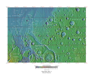
The Oxia Palus quadrangle is one of a series of 30 quadrangle maps of Mars used by the United States Geological Survey (USGS) Astrogeology Research Program. The Oxia Palus quadrangle is also referred to as MC-11.

The Iapygia quadrangle is one of a series of 30 quadrangle maps of Mars used by the United States Geological Survey (USGS) Astrogeology Research Program. The Iapygia quadrangle is also referred to as MC-21. It was named after the heel of the boot of Italy. That name was given by the Greeks It is part of a region of Italy named Apulia. The name Iapygia was approved in 1958.
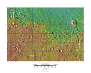
The Aeolis quadrangle is one of a series of 30 quadrangle maps of Mars used by the United States Geological Survey (USGS) Astrogeology Research Program. The Aeolis quadrangle is also referred to as MC-23 . The Aeolis quadrangle covers 180° to 225° W and 0° to 30° south on Mars, and contains parts of the regions Elysium Planitia and Terra Cimmeria. A small part of the Medusae Fossae Formation lies in this quadrangle.

The Coprates quadrangle is one of a series of 30 quadrangle maps of Mars used by the United States Geological Survey (USGS) Astrogeology Research Program. The Coprates quadrangle is also referred to as MC-18. The Coprates quadrangle contains parts of many of the old classical regions of Mars: Sinai Planum, Solis Planum, Thaumasia Planum, Lunae Planum, Noachis Terra, and Xanthe Terra.

The Margaritifer Sinus quadrangle is one of a series of 30 quadrangle maps of Mars used by the United States Geological Survey (USGS) Astrogeology Research Program. The Margaritifer Sinus quadrangle is also referred to as MC-19. The Margaritifer Sinus quadrangle covers the area from 0° to 45° west longitude and 0° to 30° south latitude on Mars. Margaritifer Sinus quadrangle contains Margaritifer Terra and parts of Xanthe Terra, Noachis Terra, Arabia Terra, and Meridiani Planum.

The Thaumasia quadrangle is one of a series of 30 quadrangle maps of Mars used by the United States Geological Survey (USGS) Astrogeology Research Program. The Thaumasia quadrangle is also referred to as MC-25 . The name comes from Thaumas, the god of the clouds and celestial apparitions.

Trouvelot is a crater on Mars, located in the Oxia Palus quadrangle at 16.2° north latitude and 13.1° west longitude near the crustal dichotomy in the circum-Chryse region. It is roughly located along the dichotomy between Arabia Terra to the northeast and the southernmost of the circum-Chryse outflow channels to the southwest. Trouvelot crater measures approximately 148.77 kilometres (92.44 mi) in diameter and was named after Étienne Léopold Trouvelot, a French astronomer (1827–1895). The name was adopted by IAU's Working Group for Planetary System Nomenclature in 1973.
Penticton is an impact crater in the Hellas quadrangle of Mars, located at 38.35° south latitude and 263.35° west longitude. Penticton is on the eastern rim of the Hellas impact crater. It is 8 kilometers in diameter and was named after Penticton, a Town in British Columbia, Canada, nearby the little town of Okanagan Falls where is located the Dominion Radio Astrophysical Observatory. Images with HiRISE show gullies which were once thought to be caused by flowing water.
Mars may contain ores that would be very useful to potential colonists. The abundance of volcanic features together with widespread cratering are strong evidence for a variety of ores. While nothing may be found on Mars that would justify the high cost of transport to Earth, the more ores that future colonists can obtain from Mars, the easier it would be to build colonies there.

The composition of Mars covers the branch of the geology of Mars that describes the make-up of the planet Mars.

In summer 1965, the first close-up images from Mars showed a cratered desert with no signs of water. However, over the decades, as more parts of the planet were imaged with better cameras on more sophisticated satellites, Mars showed evidence of past river valleys, lakes and present ice in glaciers and in the ground. It was discovered that the climate of Mars displays huge changes over geologic time because its axis is not stabilized by a large moon, as Earth's is. Also, some researchers maintain that surface liquid water could have existed for periods of time due to geothermal effects, chemical composition or asteroid impacts. This article describes some of the places that could have held large lakes.