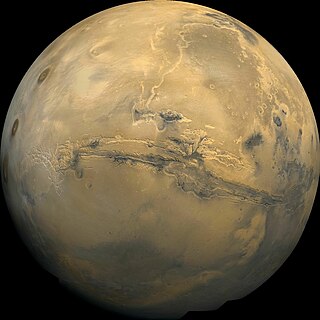
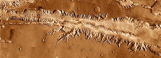
Valles Marineris is a system of canyons that runs along the Martian surface east of the Tharsis region. At more than 4,000 km (2,500 mi) long, 200 km (120 mi) wide and up to 7 km (23,000 ft) deep, Valles Marineris is one of the largest canyons of the Solar System, surpassed in length only by the rift valleys of the mid-ocean ridge system of Earth.
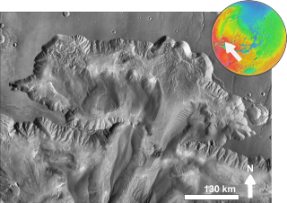
Noctis Labyrinthus is a region of Mars located in the Phoenicis Lacus quadrangle, between Valles Marineris and the Tharsis upland. The region is notable for its maze-like system of deep, steep-walled valleys. The valleys and canyons of this region formed by faulting and many show classic features of grabens, with the upland plain surface preserved on the valley floor. In some places the valley floors are rougher, disturbed by landslides, and there are places where the land appears to have sunk down into pit-like formations. It is thought that this faulting was triggered by volcanic activity in the Tharsis region. Research described in December 2009 found a variety of minerals, including clays, sulfates, and hydrated silicas, in some of the layers.
Vallis or valles is the Latin word for valley. It is used in planetary geology to name landform features on other planets.

The Thermal Emission Imaging System (THEMIS) is a camera on board the 2001 Mars Odyssey orbiter. It images Mars in the visible and infrared parts of the electromagnetic spectrum in order to determine the thermal properties of the surface and to refine the distribution of minerals on the surface of Mars as determined by the Thermal Emission Spectrometer (TES). Additionally, it helps scientists to understand how the mineralogy of Mars relates to its landforms, and it can be used to search for thermal hotspots in the Martian subsurface.

Oudemans is a crater on Mars, approximately 90 kilometers in diameter, named after Dutch astronomer Jean Abraham Chrétien Oudemans (1827–1906).
In planetary nomenclature, a chasma is a deep, elongated, steep-sided depression. As of 2020, the IAU has named 122 such features in the Solar System, on Venus (63), Mars (25), Saturn's satellites Mimas (6), Tethys (2), Dione (8) and Rhea (5), Uranus's satellites Ariel (7), Titania (2) and Oberon (1) and Pluto's satellite Charon (3). An example is Eos Chasma on Mars.

Melas Chasma is a canyon on Mars, the widest segment of the Valles Marineris canyon system, located east of Ius Chasma at 9.8°S, 283.6°E in Coprates quadrangle. It cuts through layered deposits that are thought to be sediments from an old lake that resulted from runoff of the valley networks to the west. Other theories include windblown sediment deposits and volcanic ash. Support for abundant, past water in Melas Chasma is the discovery by MRO of hydrated sulfates. In addition, sulfate and iron oxides were found by the same satellite. Although not chosen as one of the finalists, it was one of eight potential landing sites for the Mars 2020 rover, a mission with a focus on astrobiology.

Echus Chasma is a chasma in the Lunae Planum high plateau north of the Valles Marineris canyon system of Mars. It is in the Coprates quadrangle. Clay has been found within it, meaning that water once sat there for a time. It may have been one of the many lakes that have been advanced for the Martian past.

The Lunae Palus quadrangle is one of a series of 30 quadrangle maps of Mars used by the United States Geological Survey (USGS) Astrogeology Research Program. The quadrangle is also referred to as MC-10. Lunae Planum and parts of Xanthe Terra and Chryse Planitia are found in the Lunae Palus quadrangle. The Lunae Palus quadrangle contains many ancient river valleys.

The Coprates quadrangle is one of a series of 30 quadrangle maps of Mars used by the United States Geological Survey (USGS) Astrogeology Research Program. The Coprates quadrangle is also referred to as MC-18. The Coprates quadrangle contains parts of many of the old classical regions of Mars: Sinai Planum, Solis Planum, Thaumasia Planum, Lunae Planum, Noachis Terra, and Xanthe Terra.

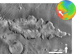
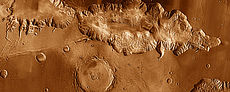
Eos Chaos is a rough, collapsed area in the Coprates quadrangle on Mars at 16.8° south latitude and 46.9° west longitude. It is about 490 km long and was named after the Greek name of Aurora, an albedo feature.

Capri Mensa is a mesa in the Coprates quadrangle of Mars at 14° south latitude and 47.4° west longitude. It is about 275 km long and was named after a classical albedo feature name.
Ophir Chasma is a canyon in the Coprates quadrangle of Mars at 4° south latitude and 72.5° west longitude. It is about 317 km long and was named after Ophir, a land mentioned in the Bible. In the Bible it was the land which King Solomon sent an expedition that returned with gold. It is a classical albedo feature name.
Ius Chasma is a large canyon in the Coprates quadrangle of Mars at 7° south latitude and 85.8° west longitude. It is about 938 km long and was named after a classical albedo feature name.
Tithonium Chasma is a large canyon in the Coprates quadrangle of Mars at 4.6° south latitude and 84.7° west longitude. It is about 810 km long and was named after a classical albedo feature.
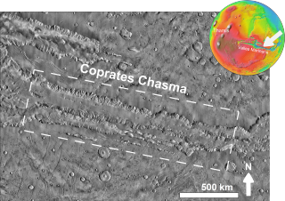
Coprates Chasma is a huge canyon in the Coprates quadrangle of Mars, located at 13.4° south latitude and 61.4° west longitude, part of the Valles Marineris canyon system. It is 966 km (600 mi) long and was named after a classical albedo feature name. It was named from the classical Greek name for the Dez River in Persia.

Ganges Mensa is a mesa and an interior layered deposit in Ganges Chasma, one of the peripheral valleys of Valles Marineris on Mars. The mesa rises up to 4 kilometres (13,000 ft) from the floor of Ganges Chasma, nearly to the same elevation as the surrounding plateaux of Lunae Planum. Like Hebes Mensa, the mesa is completely separated from the surrounding canyon walls and has sustained significant erosion that has caused it to retreat in areal extent.

In summer 1965, the first close-up images from Mars showed a cratered desert with no signs of water. However, over the decades, as more parts of the planet were imaged with better cameras on more sophisticated satellites, Mars showed evidence of past river valleys, lakes and present ice in glaciers and in the ground. It was discovered that the climate of Mars displays huge changes over geologic time because its axis is not stabilized by a large moon, as Earth's is. Also, some researchers maintain that surface liquid water could have existed for periods of time due to geothermal effects, chemical composition or asteroid impacts. This article describes some of the places that could have held large lakes.

The Thaumasia Planum of Mars lies south of Melas Chasmata and Coprates Chasmata. It is in the Coprates quadrangle. Its center is located at 21.66 S and 294.78 E. It was named after a classical albedo feature. The name was approved in 2006. Some forms on its surface are evidence of a flow of lava or water the Melas Chasma. Many wrinkle ridges and grabens are visible. One set of grabens, called Nia Fossae, seem to follow the curve of Melas Chasmata which lies just to the north.

Hebes Mensa is a large mensa that rises from the floor of Hebes Chasma, one of the chasmata of the Valles Marineris network on Mars. Some researchers have identified this mesa to be an interior layered deposit (ILD), similar to Ganges Mensa, and are named for alternating light-toned and dark-toned layers forming a stair-stepped stratigraphy. The faces of Hebes Mensa are sometimes fluted. It is 7.5 kilometres (4.7 mi) tall and 120 by 43 kilometres wide.