Genesee County, New York

Last updated

Genesee County
Genesee County Courthouse Oct 09.JPG
Flag of Genesee County, New York.gif
Seal of Genesee County, New York.png
Map of New York highlighting Genesee County.svg
Location within the U.S. state of New York
New York in United States.svg
New York's location within the U.S.
Coordinates: 43°00′N78°11′W / 43°N 78.19°W / 43; -78.19
CountryFlag of the United States.svg United States
StateFlag of New York.svg  New York
FoundedMarch 1803
Seat Batavia
Largest cityBatavia
Area
  Total495 sq mi (1,280 km2)
  Land493 sq mi (1,280 km2)
  Water2.4 sq mi (6 km2)  0.5%
Population
 (2020)
  Total58,388 [1]
  Density118.4/sq mi (45.7/km2)
Time zone UTC−5 (Eastern)
  Summer (DST) UTC−4 (EDT)
Congressional district 24th
Website www.co.genesee.ny.us

Genesee County is a county in the U.S. state of New York. As of the 2020 census, the population was 58,388. [2] Its county seat is Batavia. [3] Its name is from Seneca word Gen-nis'-hee-yo, meaning "the Beautiful Valley". [4] The county was created in 1802 and organized in 1803. [5] The county is part of the Finger Lakes region of the state.

Contents

Genesee County comprises the Batavia, NY micropolitan statistical area, which is also in the Rochester-Batavia-Seneca Falls, NY combined statistical area. It is in Western New York. It is the namesake of Genesee County, Michigan; that is, the Michigan county was named for Genesee County, New York.

History

Precontact era

The archaeological record at the Hiscock Site, in Byron, New York goes back 10,000 to 12,000 years to the Ice Age. Researchers have found a variety of humanmade tools, ceramics, metal, and leather, along with a mastodon jaw, tusks, and teeth and assorted animal bones, indicating long occupation of the site. This site is among North America's most important for archaeological artifacts from the Ice Age. [6] [7]

Different Indigenous peoples lived in the area for thousands of years. Centuries before European arrival, the Iroquoian-speaking Seneca Nation developed in the central part of present-day New York; it became one of the first Five Nations of the Haudenosaunee (Iroquois Confederacy). Beginning in 1639 and lasting for the rest of the century, the Seneca led an invasion of Western New York, driving out the existing tribes of Wenro, Erie and Neutrals.

Colonial and revolutionary era

When counties were established in New York State in 1683, the present Genesee County was part of Albany County. This was an enormous county, including the northern part of New York State as well as all of the present State of Vermont and, in theory, extending westward to the Pacific Ocean. On March 12, 1772, what was left of Albany County was split into three parts, one remaining under the name Albany County. One of the other pieces, Tryon County, contained the western portion (and thus, since no western boundary was specified, theoretically still extended west to the Pacific). In 1784 Tryon County was renamed as Montgomery County. Around this time, the Pennsylvania Colony and the Massachusetts Bay Colony also claimed the territory as their own, but New York did not enforce its territorial claim. In 1789 Ontario County was split off from Montgomery as a result of the Phelps and Gorham Purchase. Again, the county theoretically extended west to the Pacific Ocean.

New York State

It was not until the Holland Purchase of 1793 that Western New York was enforced as the territory of New York State. Land in the region was sold through the Holland Land Company's office in Batavia, starting in 1801. All the land in Western New York was in the newly created Genesee County, and all of that was in the single town of Batavia.

Genesee County was created by a partition of 7,100 square miles (18,000 km2) of land from Ontario County. The county was not fully organized so it remained under the supervision of Ontario County until it achieved full organization and separation during March 1803. [8]

On April 7, 1806, Genesee's area was reduced to 5,550 square miles (14,400 km2) due to a partition that created Allegany County. [9] On March 8, 1808, Genesee's area was again reduced, this time to 1,650 square miles (4,300 km2) due to a partition that created Cattaraugus, Chautauqua, and Niagara Counties. [10] On February 23, 1821, Genesee's area was again reduced, this time to 1,450 square miles (3,800 km2) due a complex partition that produced Livingston [11] and Monroe Counties. [12] On April 15, 1825, another partition reduced Genesee's area to 1,030 square miles (2,700 km2) in the creation of Orleans County. [13] [14] On May 1, 1826, the Orleans partition was again surveyed, with 10 square miles (26 km2) of land along the western half of the Orleans/Genesee border returned to Genesee. [15] On March 19, 1841, Genesee's area was again reduced, this time to the 500 square miles (1,300 km2) it remains to this day due to the partitioning to create Wyoming County. [16]

19th century politics: Origins of antimasonry

Genesee County was included in the 19th century "burned-over district" — the Western region of New York consumed by religious revivals and characterized by "the evangelical desire to convert the entire American population to Christianity and to create a 'moral, homogeneous commonwealth.'" [17] This religious moral crusade provided the social atmosphere that allowed antimasonic sentiment to gain momentum as a significant church-oriented movement and, later, a grass-roots political party that became the nation's first third party.[ citation needed ]

By the 1820s, Freemasonry was prevalent in Genesee County. From 1821 to 1827, half of all county officials were Freemasons. [18] In September 1826, William Morgan, a resident of Batavia, New York, disappeared after having been briefly imprisoned for failure to repay a debt. Morgan had been rejected from the Masonic lodge in Batavia, and, as a result, threatened to publish a book which exposed the secret rituals of Freemasonry. His disappearance and presumed murder ignited a campaign against Freemasonry. The investigation into Morgan's disappearance confronted major obstacles from government officials and the judiciary- positions that were largely occupied by Freemasons. [19] The Morgan affair combined with existing suspicions and distrust of the secrecy of Freemasonry initiated mass meetings throughout the county to decide how the issue of Freemasonry should be handled. The Antimasonry crusade's original goal was to oust Masons from political offices. Through the political guidance of party organizers, such as Thurlow Weed and William H. Seward, the crusade developed into a political party that enjoyed a political stronghold in Genesee County and the rest of the "burned-over district."

The Antimasonic Party found strong support within Genesee County from 1827 to 1833. The party averaged 69 percent of the vote and won every county office. [19] After continuous domination of Masonic politicians, citizens saw Antimasonry as a solution and an opportunity to restore justice and republicanism. The Baptist and Presbyterian churches favored Antimasonry and encouraged their members to renounce ties with the fraternity. The party was originally associated with populist rhetoric, however, strong Antimasonic sentiment throughout the county correlated with positive economic developments and high population densities. Larger towns, such as Batavia, the county seat and Le Roy, harbored the strongest support for the party. [20] The timing of the creation of the Antimasonic Party coincided with a time in New York politics that encouraged the expansion of political participation. The party leaders made the Antimasonic Party, and later the Whig Party, a great success in Genesee County and other neighboring counties.

Modern day

In 2009, the City and Town of Batavia began exploring ways to merge or consolidate governmental systems.

Geography

According to the U.S. Census Bureau, the county has a total area of 495 square miles (1,280 km2), of which 493 square miles (1,280 km2) is land and 2.4 square miles (6.2 km2) (0.5%) is water. [21] Genesee County is east of Buffalo and southwest of Rochester in the western portion of New York State.

Adjacent counties

Major highways

Genesee County watersheds

Source: [22]

National protected area

State protected areas

County parks

Source: [23]

Government and politics

Genesee County is governed by a 9–member legislature headed by a chairperson. Genesee County is part of the 8th Judicial District of the New York Supreme Court and the 4th Department of the New York Supreme Court, Appellate Division.

OfficeDistrictArea of the countyOfficeholderPartyFirst took office
Congressman New York's 24th congressional district All [24] Claudia Tenney Republican2021
State Senator 61st State Senate District All [25] Sean Ryan Democratic2021
State Assemblyman 139th State Assembly District All [26] Stephen M. Hawley Republican2006

Presidential elections

Genesee County is solidly Republican at the Presidential level with Lyndon Johnson in 1964 being the only Democrat to ever carry the county. Since then the closest a Democrat has gotten to winning the county was Bill Clinton in 1996 when he lost to Bob Dole by 3 percent. In 2020 Donald Trump received 64.6 percent of the vote which was the best result for a Republican since 1984 when Ronald Reagan received 65.8 percent.

United States presidential election results for Genesee County, New York [27]
Year Republican Democratic Third party
No.%No.%No.%
2020 18,87664.61%9,62532.94%7162.45%
2016 16,91563.99%7,65028.94%1,8677.06%
2012 14,60759.03%9,60138.80%5382.17%
2008 15,70558.40%10,76240.02%4231.57%
2004 16,72560.64%10,33137.46%5241.90%
2000 14,45955.45%10,19139.08%1,4245.46%
1996 10,82144.64%10,07441.56%3,34313.79%
1992 11,66344.47%8,07130.78%6,49124.75%
1988 14,18258.29%9,94540.87%2050.84%
1984 16,58265.78%8,54933.91%790.31%
1980 11,65047.57%10,67743.60%2,1628.83%
1976 14,56757.04%10,80342.30%1660.65%
1972 17,10766.28%8,63133.44%730.28%
1968 12,41853.64%9,53341.18%1,1995.18%
1964 8,11434.03%15,71365.91%140.06%
1960 14,72458.70%10,34341.23%180.07%
1956 17,61474.64%5,98625.36%00.00%
1952 16,60670.85%6,81929.10%120.05%
1948 12,65062.80%7,02434.87%4682.32%
1944 13,47866.32%6,79633.44%500.25%
1940 14,50368.32%6,66431.39%620.29%
1936 13,29266.23%6,17730.78%6002.99%
1932 11,88164.80%6,15233.55%3021.65%
1928 13,25169.03%5,18126.99%7633.97%
1924 11,10171.43%3,38421.77%1,0576.80%
1920 9,62874.50%2,57019.89%7255.61%
1916 5,59064.39%2,80232.27%2903.34%
1912 3,23139.10%2,65632.14%2,37728.76%
1908 5,79462.26%3,17134.07%3413.66%
1904 5,81063.89%2,88331.70%4014.41%
1900 5,38559.82%3,26736.29%3503.89%
1896 5,19061.50%3,00435.60%2452.90%
1892 4,28951.99%3,25039.40%7108.61%
1888 4,95255.07%3,63340.40%4084.54%
1884 4,63153.22%3,64341.87%4274.91%

Law enforcement

The primary law enforcement agency is the Genesee County Sheriff's Office. [28]

In most counties in N.Y., the undersheriff is the warden of the county jail. [29] In Genesee County, the sheriff has ultimate authority to operate the 80-bed county jail, built in 1985. In this county, rather than an undersheriff, it is managed by a "jail superintendent" with 27 other employees and managers. The current Genesee County Jail was built in 1985. [30]

Demographics

Historical population
CensusPop.Note
1810 12,588
1820 58,093361.5%
1830 52,147−10.2%
1840 59,58714.3%
1850 28,488−52.2%
1860 32,18913.0%
1870 31,606−1.8%
1880 32,8063.8%
1890 33,2651.4%
1900 34,5613.9%
1910 37,6158.8%
1920 37,9761.0%
1930 44,46817.1%
1940 44,4810.0%
1950 47,5847.0%
1960 53,99413.5%
1970 58,7228.8%
1980 59,4001.2%
1990 60,0601.1%
2000 60,3700.5%
2010 60,079−0.5%
2020 58,388−2.8%
U.S. Decennial Census [31]
1790-1960 [32] 1900-1990 [33]
1990-2000 [34] 2010-2020 [2]

2020 Census

Genesee County Racial Composition [35]
RaceNum.Perc.
White (NH)50,96087.3%
Black or African American (NH)1,3582.32%
Native American (NH)3610.62%
Asian (NH)4120.71%
Pacific Islander (NH)160.02%
Other/Mixed (NH)2,5294.33%
Hispanic or Latino 2,7524.71%

2000 census

As of the 2000 census, [36] there were 60,370 people, 22,770 households, and 15,825 families residing in the county. The population density was 122 people per square mile (47 people/km2). There were 24,190 housing units, with an average density of 49 units per square mile (19/km2). The county's racial makeup was 94.69% White, 2.13% Black or African American, 0.78% Native American, 0.48% Asian, 0.02% Pacific Islander, 0.71% from other races, and 1.18% from two or more races. 1.50% of the population were Hispanic or Latino of any race. 25.0% were of German, 15.2% Italian, 13.5% English, 13.1% Irish, 8.9% Polish and 5.6% American ancestry according to Census 2000. [37] 96.5% spoke English and 1.5% Spanish as their first language.

There were 22,770 households, of which 33.30% had children under the age of 18. 55.4% were married couples living together, 9.80% had a female householder with no husband present, and 30.50% were non-families. 24.80% of households were made up of individuals, and 11.10% had someone living alone who was 65 years of age or older. The average household size was 2.59 and the average family size was 3.10.

26.10% of the county's population was under the age of 18, 7.50% were from age 18 to 24, 29.50% were from age 25 to 44, 22.60% were from age 45 to 64, and 14.30% were age 65 or older. The median age was 37 years. For every 100 females there were 96.90 males. For every 100 females age 18 and over, there were 95.00 males.

The U.S. Census in 2000 showed the county had a 63.7% employment rate and 2.9% were unemployed. The median household income was $40,542, and the median family income was $47,771. Males had a median income of $34,430 versus $23,788 for females. The county's per capita income was $18,498. About 5.60% of families and 7.60% of the population were below the poverty line, including 9.00% of those under age 18 and 6.80% of those age 65 or over. [38]

Education

The county has eight public school districts: [39]

It has one state-operated school: New York State School for the Blind

Several private schools at the primary and secondary levels are also maintained:

Genesee Community College has its main campus in the Town of Batavia.

Communities

Larger Settlements

#LocationPopulationTypeSector
1Batavia 15,600CityNorthwest
2 Le Roy 4,391VillageSoutheast
3Attica 2,547VillageSouthwest
4 Oakfield 1,813VillageNorthwest
5 Bergen 1,176VillageNortheast
6 Corfu 709VillageSouthwest
7 Elba 676VillageNortheast
8 Pavilion 646CDPSoutheast
9 Alexander 509VillageSouthwest

† - County Seat

‡ - Not Wholly in this County

Towns

Other hamlets

Indian reservations

See also

Related Research Articles

<span class="mw-page-title-main">Allegany County, New York</span> County in New York, United States

Allegany County is a county in the U.S. state of New York. As of the 2020 census, the population was 46,456. Its county seat is Belmont. Its name derives from a Lenape word, applied by European-American settlers of Western New York State to a trail that followed the Allegheny River; they also named the county after this. The county is part of the Western New York region of the state.

<span class="mw-page-title-main">Chautauqua County, New York</span> County in New York

Chautauqua County is the westernmost county in the U.S. state of New York. As of the 2020 census, the population was 127,657. Its county seat is Mayville, and its largest city is Jamestown. Its name is believed to be the lone surviving remnant of the Erie language, a tongue lost in the 17th century Beaver Wars; its meaning is unknown and a subject of speculation. The county was created in 1808 and organized in 1811. The county is part of the Western New York region of the state.

<span class="mw-page-title-main">Greene County, New York</span> County in New York, United States

Greene County is a county located in the U.S. state of New York. As of the 2020 census, the population was 47,931. Its county seat is Catskill. The county's name is in honor of the American Revolutionary War general Nathanael Greene. The county is part of the Capital District region of the state.

<span class="mw-page-title-main">Orleans County, New York</span> County in New York, United States

Orleans County is a county in the western part of the U.S. state of New York. As of the 2020 census, the population was 40,343. The county seat is Albion. The county received its name at the insistence of Nehemiah Ingersoll though historians are unsure how the name was selected. The two competing theories are that it was named to honor the French Royal House of Orleans or that it was to honor Andrew Jackson's victory in New Orleans. The county is part of the Finger Lakes region of the state.

<span class="mw-page-title-main">Wyoming County, New York</span> County in New York, United States

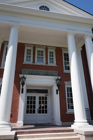
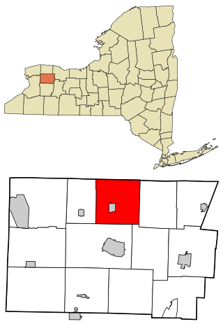
Wyoming County is a county in the U.S. state of New York in the state's western area. As of the 2020 census, the population was 40,531. The county seat is Warsaw. The name is modified from a Lenape (Delaware) Native American word meaning "broad bottom lands". Wyoming County was formed from Genesee County in 1841. Wyoming County is one of New York's mostly agricultural counties. With an estimated 47,500 dairy cows in the county, there are more cattle in Wyoming County than people. The county is part of the Finger Lakes region of the state.

<span class="mw-page-title-main">Yates County, New York</span> County in New York, United States

Yates County is a county in the U.S. state of New York. As of the 2020 Census, the population was 24,774, making it the third-least populous county in New York. The county seat is Penn Yan. The name is in honor of Joseph C. Yates, who as Governor of New York signed the act establishing the county. The county is part of the Finger Lakes region of the state.

<span class="mw-page-title-main">Bethany, New York</span> Town in New York, United States

Bethany is a town in Genesee County, New York, United States. The population was 1,765 at the 2010 census. The town lies on the southern border of Genesee County. US Route 20 and NYS Route 63 pass through the town.

<span class="mw-page-title-main">Corfu, New York</span> Village in New York, United States

Corfu is a village in Genesee County, New York, United States. The population was 709 at the 2010 census. It is named after the Greek island of Corfu.

<span class="mw-page-title-main">Darien, New York</span> Town in Genesee County, New York

Darien is a town in Genesee County, New York, United States. The population was 3,158 at the 2010 census. Darien lies in the southwestern part of Genesee County, southwest of Batavia.

<span class="mw-page-title-main">Pembroke, New York</span> Town in New York, United States

Pembroke is a town in Genesee County, Western New York, United States. The population was 4,292 at the 2010 census. The town is named after a town in west Wales. Pembroke lies on the west border of Genesee County, west of Batavia.

<span class="mw-page-title-main">Stafford, New York</span> Town in New York, United States

Stafford is a town in Genesee County, New York, United States. The population was 2,459 at the 2010 census. The town was named after a town of the same name in England.

<span class="mw-page-title-main">Rush, New York</span> Town in New York, United States

Rush is a town in Monroe County, New York, United States. The population was 3,478 at the 2010 census.

<span class="mw-page-title-main">Attica, New York</span> Town in New York, United States

Attica is a town in Wyoming County, New York, United States. The population was 7,702 as of 2010.

<span class="mw-page-title-main">Alexander (village), New York</span> Village in New York, United States

Alexander is a village in Genesee County, New York, United States. The population was 509 at the 2010 census. The village is named after early settler, Alexander Rea.

<span class="mw-page-title-main">Alexander, New York</span> Town in New York, United States

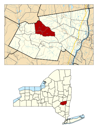
Alexander is a town in Genesee County, New York, United States. The population was 2,491 at the 2020 census. The town is named after Alexander Rea, an early settler, and is on the southern border of the county. It includes a village also named Alexander.

<span class="mw-page-title-main">Batavia (town), New York</span> Town in New York, United States

Batavia is a town in Genesee County, New York, United States. The population was 6,293 at the 2020 census. The name is derived from the Roman name for part of the Netherlands.

<span class="mw-page-title-main">Elba, New York</span> Town in New York, United States

Elba is a town in Genesee County, New York, United States. The population was 2,370 at the 2010 census. The town is at the northern border of the county and is north of the city of Batavia. The town contains the village of Elba, located near the town's center.

<span class="mw-page-title-main">Windham (town), New York</span> Town in New York, United States

Windham is a town in Greene County, New York, United States. The population was 1,708 at the 2020 census. The town was probably named for the town or county of Windham, Connecticut, as many of its earliest settlers came from that state as well as other parts of New England. The town has two nicknames: "Land in the Sky" and "Gem of the Catskills".

<span class="mw-page-title-main">Warsaw, New York</span> Town in New York, United States

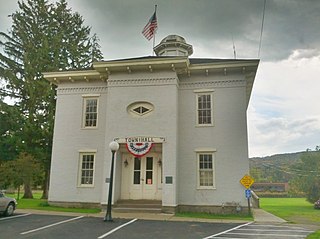
Warsaw is a town in Wyoming County, in the U.S. state of New York. The population was 5,316 at the 2020 census. It is located approximately 37 miles east southeast of Buffalo and approximately 37 miles southwest of Rochester. The town may have been named after Warsaw, Poland.

Pavilion is a hamlet and census-designated place within the town of Pavilion in Genesee County, New York, United States. As of the 2010 census, the population of the CDP was 646, out of a total of 2,495 people in the town as a whole.

References

  1. "US Census 2020 Population Dataset Tables for New York". United States Census Bureau. Retrieved January 2, 2022.
  2. 1 2 "U.S. Census Bureau QuickFacts: Genesee County, New York". United States Census Bureau. Retrieved January 3, 2022.
  3. "Find a County". National Association of Counties. Archived from the original on May 31, 2011. Retrieved June 7, 2011.
  4. THE AMERICAN REVIEW; A WHIG JOURNAL DEVOTED TO POLITICS, LITERATURE, ART AND SCIENCE. VOL. VI NEW-YORK: GEORGE H. COLTON, 118 NASSAU STREET, Published 1847, Wiley and Putnam, p. 628.
  5. "New York: Individual County Chronologies". New York Atlas of Historical County Boundaries. The Newberry Library. 2008. Archived from the original on April 10, 2015. Retrieved January 9, 2015.
  6. Geology Archived July 3, 2008, at the Wayback Machine The Buffalo Museum of Science, Retrieved on December 5, 2007
  7. "Excavation pit at the Byron Dig" Archived February 7, 2009, at the Wayback Machine , The Buffalo Museum of Science, Retrieved on December 5, 2007
  8. New York. Laws of New York.:1802, 25th Session, Chapter 64, Page 97.
  9. New York. Laws of New York.:1806, 29th Session, Chapter 162, Section 1, Page 604.
  10. New York. Laws of New York.:1808, 31st Session, Chapter 15, Page 254.
  11. New York. Laws of New York.:1820, 44th Session, Chapter 58, Section 1, Page 50.
  12. New York. Laws of New York.:1820, 44th Session, Chapter 57, Section 1, Page 46.
  13. New York. Laws of New York.:1824, 47th Session, Chapter 266, Section 1, Page 326.
  14. New York. Laws of New York.:1825, 48th Session, Chapter 181, Sections 1 & 2, Page 273.
  15. New York. Laws of New York.:1826, 49th Session, Chapter 269, Page 302.
  16. New York. Laws of New York.:1841, 64th Session, Chapter 196, Section 1, Page 169.
  17. William Preston Vaughn, The Antimasonic Party in the United States, 1826-1843 (Lexington: University Press of Kentucky, 1983), 21.
  18. Ronald P. Formisano and Kathleen Smith Kutolowski, "Antimasonry and Masonry: The Genesis of Protest, 1826-1827," American Quarterly 29 (1977): 145.
  19. 1 2 Kathleen Smith Kutolowski (1984). "Antimasonry reexamined: social bases of the grass-roots party". Journal of American History . 71 (2): 269–293. doi:10.2307/1901756. JSTOR   1901756.
  20. Darcy G. Richardson, Others: Third-Party Politics From the Nation's Founding to the Rise and Fall of the Greenback-Labor Party (New York: iUniverse, Inc., 2004), 51.
  21. "2010 Census Gazetteer Files". United States Census Bureau. August 22, 2012. Archived from the original on May 19, 2014. Retrieved January 4, 2015.
  22. Genesee County All Hazard Multi-Jurisdictional Mitigation Plan, Chapter 4 Maps (1st Draft, May 2007) Archived December 3, 2007, at the Wayback Machine (See Watersheds-Genesee County, NY, Map 5), Genesee/Finger Lakes Regional Planning Council
  23. Genesee County Park and Forest
  24. W, Eric (April 2, 2012). "Congressional District 27" (PDF). View 2012 Congressional Maps. Albany, New York: The New York State Legislative Task Force on Demographic Research and Reapportionment. Retrieved January 13, 2013.
  25. W, Eric (March 2, 2012). "Senate District 61" (PDF). View 2012 Senate District Maps. Albany, New York: The New York State Legislative Task Force on Demographic Research and Reapportionment. Retrieved January 6, 2013.
  26. W, Eric (January 25, 2012). "Assembly District 139" (PDF). View Proposed 2012 Assembly District Maps. Albany, New York: The New York State Legislative Task Force on Demographic Research and Reapportionment. Retrieved January 13, 2013.
  27. Leip, David. "Dave Leip's Atlas of U.S. Presidential Elections". uselectionatlas.org. Retrieved October 22, 2018.
  28. "Sheriff's Office". www.co.genesee.ny.us. Retrieved October 24, 2021.
  29. See N.Y. County Law, article 17, sections 652, found online at NYPublicLaw, type in CNT, then Article 17, and finally click on 652.
  30. "County Law, Article 17, Section 650, acknowledges the Sheriff as an Officer of the Court; Correction Law, Article 20, Section 500C, designates the Sheriff as custodian of the County Jail," from Genesee County government web site Jail page Archived February 25, 2011, at the Wayback Machine . Accessed June 26, 2008.
  31. "U.S. Decennial Census". United States Census Bureau. Retrieved January 4, 2015.
  32. "Historical Census Browser". University of Virginia Library. Archived from the original on December 26, 2013. Retrieved January 4, 2015.
  33. "Population of Counties by Decennial Census: 1900 to 1990". United States Census Bureau. Retrieved January 4, 2015.
  34. "Census 2000 PHC-T-4. Ranking Tables for Counties: 1990 and 2000" (PDF). United States Census Bureau. Retrieved January 4, 2015.
  35. "P2 HISPANIC OR LATINO, AND NOT HISPANIC OR LATINO BY RACE – 2020: DEC Redistricting Data (PL 94-171) – Genesee County, New York".
  36. "U.S. Census website". United States Census Bureau . Retrieved January 31, 2008.
  37. U.S. Census website . Factfinder.census.gov. Retrieved on August 2, 2013.
  38. "U.S. Census Bureau, Selected Economic Characteristics: 2000, Genesee County, New York". Archived from the original on February 12, 2020. Retrieved December 5, 2007.
  39. "2020 CENSUS - SCHOOL DISTRICT REFERENCE MAP: Genesee County, NY" (PDF). U.S. Census Bureau . Retrieved July 20, 2022. - Text list

Further reading

43°00′N78°11′W / 43.00°N 78.19°W / 43.00; -78.19