Montgomery County, New York

Last updated

Montgomery County
House in Amsterdam, NY crop.jpg
Flag of Montgomery County, New York.jpg
Montgomery County Seal.gif
Map of New York highlighting Montgomery County.svg
Location within the U.S. state of New York
New York in United States.svg
New York's location within the U.S.
Coordinates: 42°55′N74°26′W / 42.91°N 74.44°W / 42.91; -74.44
CountryFlag of the United States.svg United States
StateFlag of New York.svg  New York
FoundedMarch 12, 1772
Named for Richard Montgomery
Seat Fonda
Largest city Amsterdam
Area
  Total410 sq mi (1,100 km2)
  Land403 sq mi (1,040 km2)
  Water7.3 sq mi (19 km2)  1.8%
Population
 (2020)
  Total49,532 [1]
  Density122.9/sq mi (47.5/km2)
Time zone UTC−5 (Eastern)
  Summer (DST) UTC−4 (EDT)
Congressional district 21st
Website www.co.montgomery.ny.us

Montgomery County is a county in the U.S. state of New York. As of the 2020 census, the population was 49,532. [2] The county seat is Fonda. [3] The county was named in honor of Richard Montgomery, an American Revolutionary War general killed in 1775 at the Battle of Quebec. The county is part of the Mohawk Valley region of the state.

Contents

Historically occupied by the Mohawk people, one of the original Five Nations of the Iroquois Confederacy, the county was created in 1772 during the period of British colonial rule as Tryon County. In 1784, after the Americans gained independence in the War, it was renamed Montgomery County for one of the heroes. [4]

Montgomery County comprises the Amsterdam, NY micropolitan statistical area. The county borders the north and south banks of the Mohawk River.

History

Major general Richard Montgomery, namesake of Montgomery County Chappel Montgomery full length.jpg
Major general Richard Montgomery, namesake of Montgomery County

This area was occupied by the Mohawk for hundreds of years prior to European colonization. Many warriors allied with the British during the war. When the British lost, they ceded all the Iroquois territory of the Six Nations (the Tuscarora had joined the confederacy in the 18th century) to the United States, without consulting the tribes or bringing them into negotiation.

In 1784, following end of the American Revolutionary War, the European-American settlers renamed Tryon County as Montgomery County. This change was to honor the general, Richard Montgomery, who had captured several places in Canada and died in 1775 attempting to capture the city of Quebec during the Revolutionary War. It replaced the name that formerly honored the last provincial governor of New York.

In 1789, Ontario County was split off from Montgomery. The area of the new county was much larger than the present Ontario County, as it included the present Allegany, Cattaraugus, Chautauqua, Erie, Genesee, Livingston, Monroe, Niagara, Orleans, Steuben, Wyoming, Yates, and part of Schuyler and Wayne counties.

In 1791, Herkimer, Otsego, and Tioga counties were split off from Montgomery. In 1802, portions of Clinton, Herkimer, and Montgomery counties were combined to form St. Lawrence County. In 1816, Hamilton County was split off from Montgomery, but it did not have enough taxable inhabitants to be separately organized [5] until 1847. In May 1836, the county seat was moved from Johnstown to Fonda, [6] and in April 1838, Fulton County was split off, with Johnstown regaining that rank for the new Fulton County.

In 2012, Montgomery County voters approved a charter for government, making it the 21st county in New York state to do so. In 2013, Matthew L. Ossenfort was elected at-large as the first County Executive in the county's history. Ossenfort took office in 2014, the same year the charter went into effect. Under the terms of the charter, the Board of Supervisors was replaced by a nine-member County Legislature, with members elected from single-member districts. Thomas L. Quackenbush, one of the members, was elected as the first chairman of the new legislative body, which will be a circulating position.

Congressional districts

Geography

According to the U.S. Census Bureau, the county has a total area of 410 square miles (1,100 km2), of which 403 square miles (1,040 km2) is land and 7.3 square miles (19 km2) (1.8%) is water. [7]

Montgomery County is located in the central part of the state, west of the city of Schenectady and northwest of Albany.

Adjacent counties

The Erie Canal runs through Montgomery County parallel to the Mohawk River, connecting to the Wood River to the west, which leads to Lake Ontario. Overall, the canal connected Great Lakes shipping with the Hudson River and the port of New York on the Atlantic Ocean. Several towns and villages developed along the canal, as it carried much trade and passenger traffic during its peak years. After the railroad was built through the state, along the same river plain, it superseded the canal, which was filled in some areas.

At the time of the canal's construction, Montgomery County was the only place where there was a break in the Appalachian Mountains. Called 'The Noses' because of canal construction, it became known as "the gateway to the West". In the mid-twentieth century, the NYS Thruway was constructed parallel to the former east–west routes of the canal and railroad. Today the Erie Canal and its lock system is used primarily for recreational boat use among locals and tourists.

Montgomery County is located in the heart of the state's Mohawk Valley region. Foothills of the Catskill Mountains dot the southern part of the county, while foothills of the Adirondack Mountains dot the north.

Demographics

Historical population
CensusPop.Note
1790 28,848
1800 22,051−23.6%
1810 41,21486.9%
1820 37,569−8.8%
1830 43,71516.4%
1840 35,818−18.1%
1850 31,992−10.7%
1860 30,866−3.5%
1870 34,45711.6%
1880 38,31511.2%
1890 45,69919.3%
1900 47,4883.9%
1910 57,56721.2%
1920 57,9280.6%
1930 60,0763.7%
1940 59,142−1.6%
1950 59,5940.8%
1960 57,240−4.0%
1970 55,883−2.4%
1980 53,439−4.4%
1990 51,981−2.7%
2000 49,708−4.4%
2010 50,2191.0%
2020 49,532−1.4%
U.S. Decennial Census [8]
1790-1960 [9] 1900-1990 [10]
1990-2000 [11] 2010-2020 [2]
Montgomery County population distribution by age and sex (2000 census) USA Montgomery County, New York age pyramid.svg
Montgomery County population distribution by age and sex (2000 census)

As of the census [12] of 2010, there were 50,208 people, 20,073 households, and 13,131 families residing in the county. The population density was 123 people per square mile (47 people/km2). There were 22,522 housing units at an average density of 56 per square mile (22/km2). The racial makeup of the county was 92.87% (83.8% Non-Hispanic; 9.07 White Hispanic) White, 1.15% African American, 0.25% Native American, 0.53% Asian, 0.01% Pacific Islander, 3.92% from other races, and 1.27% from two or more races. Hispanic or Latino of any race were 12.91% of the population. 19.0% identified as being of Italian, 15.9% German, 13.5% Polish, 9.8% Puerto Rican 9.1% Irish, 7.9% American and 6.4% English ancestry, according to Census 2010. 86.8% spoke English, 9.3% Spanish,1.8% Italian, and 1.1% Polish as their first language.

There were 20,038 households, out of which 29.40% had children under the age of 18 living with them, 49.00% were married couples living together, 11.60% had a female householder with no husband present, and 34.60% were non-families. 29.50% of all households were made up of individuals, and 14.90% had someone living alone who was 65 years of age or older. The average household size was 2.42 and the average family size was 2.98.

In the county, the population was spread out, with 24.50% under the age of 18, 7.20% from 18 to 24, 26.30% from 25 to 44, 22.90% from 45 to 64, and 19.20% who were 65 years of age or older. The median age was 40 years. For every 100 females there were 91.40 males. For every 100 females age 18 and over, there were 87.90 males.

The median income for a household in the county was $33,128, and the median income for a family was $40,688. Males had a median income of $31,818 versus $23,359 for females. The per capita income for the county was $17,005. About 9.00% of families and 13.7% of the population were below the poverty line, including 17.80% of those under age 18 and 9.89% of those age 65 or over.

2020 Census

Montgomery County Racial Composition [13]
RaceNum.Perc.
White (NH)38,23777.2%
Black or African American (NH)9872.0%
Native American (NH)830.2%
Asian (NH)4791.0%
Pacific Islander (NH)90.01%
Other/Mixed (NH)2,4255.0%
Hispanic or Latino 7,31215.0%

Politics and government

In 2012, voters approved a county charter under New York's municipal home rule law which established an independent county executive to head its executive branch and replacing the board of supervisors with a nine-seat county legislature. [14] Elections were held the next year and the county began operating under this charter on January 1, 2014.

County executives
NamePartyTerm
Matthew L. Ossenfort Republican January 1, 2014 – present
State Senate
DistrictNamePartyTerritory
46 Neil Breslin Democratic Entire county
State Assembly
DistrictNamePartyTerritory
111 Angelo Santabarbara Democratic Amsterdam (both city and town), Florida
118 Robert Smullen Republican Mohawk, Glen, Charleston, Root, Palatine, Canajoharie, Minden, St. Johnsville
U.S. House
DistrictNamePartyTerritory
NY-21 Elise Stefanik Republican Entire county
U.S. Senate
NamePartyTerritory
Chuck Schumer Democratic Statewide
Kirsten Gillibrand Democratic Statewide
United States presidential election results for Montgomery County, New York [15]
Year Republican  /  Whig Democratic Third party
No.%No.%No.%
2020 12,74560.22%7,97737.69%4422.09%
2016 11,30159.31%6,59534.61%1,1586.08%
2012 9,33451.33%8,49346.70%3591.97%
2008 10,71153.09%9,08045.01%3841.90%
2004 11,33853.43%9,44944.53%4342.05%
2000 9,76546.93%10,24949.25%7953.82%
1996 7,17233.88%10,48549.54%3,50916.58%
1992 8,80237.55%9,50940.56%5,13221.89%
1988 11,12849.05%11,37150.13%1860.82%
1984 14,39861.22%9,04438.45%780.33%
1980 11,91749.48%9,64540.04%2,52410.48%
1976 13,28153.70%11,27145.57%1820.74%
1972 16,64063.58%9,46036.15%710.27%
1968 12,56649.75%11,44945.33%1,2424.92%
1964 8,47130.40%19,37069.52%200.07%
1960 14,83748.13%15,97651.82%140.05%
1956 20,67867.41%9,99632.59%00.00%
1952 19,55460.13%12,93439.77%310.10%
1948 14,21248.90%14,08548.46%7672.64%
1944 14,72650.45%14,40049.33%630.22%
1940 15,54650.71%15,07949.18%340.11%
1936 14,12748.48%14,69850.44%3141.08%
1932 14,10454.09%11,70044.87%2721.04%
1928 15,25760.28%9,84538.90%2070.82%
1924 12,86963.20%5,93929.17%1,5547.63%
1920 12,83566.07%5,91130.43%6793.50%
1916 6,70454.57%5,34743.52%2341.90%
1912 5,04042.00%4,50837.57%2,45120.43%
1908 7,57157.02%5,25439.57%4533.41%
1904 7,44457.29%5,20940.09%3402.62%
1900 7,30257.35%5,13840.36%2922.29%
1896 7,08258.39%4,75939.24%2882.37%
1892 5,72748.38%5,44546.00%6655.62%
1888 6,36552.18%5,67746.54%1561.28%
1884 5,50549.59%5,41348.77%1821.64%
1880 5,23051.21%4,94748.44%350.34%
1876 4,45748.19%4,76651.53%260.28%
1872 4,11352.28%3,74247.56%130.17%
1868 3,98151.10%3,81048.90%00.00%
1864 3,51947.38%3,90852.62%00.00%
1860 3,52852.03%3,25347.97%00.00%
1856 3,07649.03%1,48523.67%1,71327.30%
1852 2,99546.73%3,37352.63%410.64%
1848 2,92450.15%1,28522.04%1,62127.80%
1844 2,84945.86%3,27852.77%851.37%
1840 2,82846.13%3,29353.72%90.15%

Communities

City

Towns

Villages

Census-designated place

Hamlets

Notable people

See also

Related Research Articles

<span class="mw-page-title-main">Fulton County, New York</span> County in New York, United States

Fulton County is a county in the U.S. state of New York. It forms part of the state's Mohawk Valley region. Its county seat is Johnstown. At the 2020 U.S. census, the county had a population of 53,324. The county is named in honor of Robert Fulton, who is widely credited with developing the first commercially successful steamboat. The county is part of the Mohawk Valley region of the state.

<span class="mw-page-title-main">Ephratah, New York</span> Town in New York, United States

Ephratah is a town in Fulton County, New York, United States. The population was 1,682 at the 2010 census. It is named after Ephrath, a biblical town in what is now Israel.

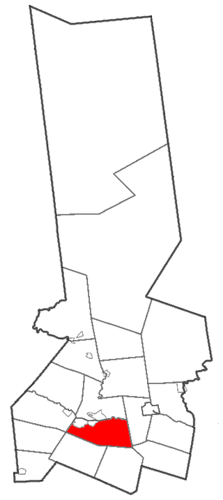
Oppenheim is a town in Fulton County, New York, United States. The town is in the southwestern corner of the county and is east of Utica. The population was 1,924 at the 2010 census.

<span class="mw-page-title-main">Danube, New York</span> Town in New York, United States

Danube is a town in Herkimer County, New York, United States. The population was 1,039 at the 2010 census. Early Palatine German immigrants in the eighteenth century named the town after the Danube River in Europe.

<span class="mw-page-title-main">German Flatts, New York</span> Town in Herkimer County, New York, US

German Flatts is a town in Herkimer County, New York, United States. The population was 12,263 at the 2020 census down from 13,258 at the 2010 census.

Mohawk is a village in Herkimer County, New York, United States. The population was 2,731 at the 2010 census. The village was named after the adjacent Mohawk River.

<span class="mw-page-title-main">Fonda, New York</span> Village in New York, United States

Fonda is a village in and the county seat of Montgomery County, New York, United States. The population was 668 at the 2020 census. The village is named after Douw Fonda, a Dutch-American settler who was killed and scalped in 1780, during a Mohawk raid in the Revolutionary War, when the tribe was allied with the British.

Fort Plain is a village in Montgomery County, New York, United States. As of the 2010 census, the village population was 2,322. The village is named after a fort built during the American Revolution at the junction of the Mohawk River and its tributary Otsquago Creek.

<span class="mw-page-title-main">Minden, New York</span> Town in New York, United States

Minden is a town in Montgomery County, New York, United States. The population was 4,297 at the 2010 census. The town is located at the western edge of the county and south of the Mohawk River, which forms its northern border. It has possessed a post office from 1802 to 1903.

<span class="mw-page-title-main">Mohawk, Montgomery County, New York</span> Town in New York, United States

Mohawk is a town in Montgomery County, New York, United States. The population was 3,844 at the 2010 census.

<span class="mw-page-title-main">Palatine, New York</span> Town in New York, United States

Town of Palatine is a town in Montgomery County, New York, United States. It is located on the north side of the Mohawk River in the northwestern part of the county. The population was 3,240 at the 2010 census, the highest since the 1820s. The name is derived from the Palatinate in the Rhineland, the homeland of the Germans who were the earliest European settlers of this region. Administrative offices of the town are located in Palatine Bridge

Palatine Bridge is a village in Montgomery County, New York, United States. The population was 737 at the 2010 census. The basis of the name is the community's location in a region settled by Palatine Germans. The Village of Palatine Bridge is in the Town of Palatine. The community is in the western part of the county, west of Amsterdam.

<span class="mw-page-title-main">Deerfield, New York</span> Town in New York, United States

Deerfield is a town in Oneida County, New York, United States. The population was 4,273 at the 2010 census.

<span class="mw-page-title-main">Johnstown, New York</span> City in New York, United States

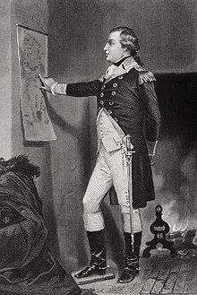
Johnstown is a city in and the county seat of Fulton County in the U.S. state of New York. The city was named after its founder, Sir William Johnson, Superintendent of Indian Affairs in the Province of New York and a major general during the Seven Years' War in North America. It is located approximately 45 miles (72 km) northwest of Albany, about one-third of the way between Albany and the Finger Lakes region to the west, in the Mohawk Valley region, within the foothills of the Adirondack Mountains.

<span class="mw-page-title-main">Herkimer (village), New York</span> Village in Herkimer County, New York, US

Herkimer is a village on the north side of the Mohawk River and the county seat of Herkimer County, New York, United States, about 15 miles (24 km) southeast of Utica. As of the 2020 Census, it had a population of 7,234, and a predicted population of 7,283 on July 1, 2022. It was part of the Burnetsfield Patent and the first colonial settlement this far west in the Mohawk Valley.

<span class="mw-page-title-main">Herkimer, New York</span> Town in New York, United States

Herkimer is a town in Herkimer County, New York, United States, southeast of Utica. It is named after Nicholas Herkimer. The population was 9,566 at the 2020 census, down from 10,175 in 2010.

<span class="mw-page-title-main">Canajoharie (village), New York</span> Village in New York, United States

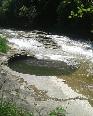
Canajoharie is a village in the Town of Canajoharie in Montgomery County, New York, United States. As of the 2010 census, the village had a population of 2,229. The name is said to be a Mohawk language term meaning "the pot that washes itself," referring to the "Canajoharie Boiling Pot," a circular gorge in the Canajoharie Creek, just south of the village.

<span class="mw-page-title-main">Canajoharie, New York</span> Town in New York, United States

Canajoharie is a town in Montgomery County, New York, United States. The population was 3,730 in 2010. Canajoharie is located south of the Mohawk River on the southern border of the county. The Erie Canal passes along the northern town line. There is also a village of Canajoharie in the town. Both are east of Utica and west of Amsterdam.

<span class="mw-page-title-main">St. Johnsville, New York</span> Town in New York, United States

St. Johnsville is a town in Montgomery County, New York, United States. The population was 2,631 at the 2010 census. Accounts vary as to the etymology of St. Johnsville, but most of them state that the town and its village are named after an early surveyor and commissioner, Alexander St. John. Still others credit the naming of St. Johnsville to a former name for the area, St. John's Church.

<span class="mw-page-title-main">Mohawk Valley</span> Six-county region in New York, United States

The Mohawk Valley region of the U.S. state of New York is the area surrounding the Mohawk River, sandwiched between the Adirondack Mountains and Catskill Mountains, northwest of the Capital District. As of the 2010 United States Census, the region's counties have a combined population of 622,133 people. In addition to the Mohawk River valley, the region contains portions of other major watersheds such as the Susquehanna River.

References

  1. "US Census 2020 Population Dataset Tables for New York". United States Census Bureau. Retrieved January 2, 2022.
  2. 1 2 "U.S. Census Bureau QuickFacts: Montgomery County, New York". United States Census Bureau. Retrieved January 2, 2022.
  3. "Find a County". National Association of Counties. Retrieved June 7, 2011.
  4. "New York: Individual County Chronologies". New York Atlas of Historical County Boundaries. The Newberry Library. 2008. Archived from the original on April 10, 2015. Retrieved January 10, 2015.
  5. "A Gazetteer of New York State," Horatio Gates Spafford, second edition, 1824, p. 218
  6. https://www.fultoncountyny.gov/fulton-county-court-house
  7. "2010 Census Gazetteer Files". United States Census Bureau. August 22, 2012. Archived from the original on May 19, 2014. Retrieved January 5, 2015.
  8. "U.S. Decennial Census". United States Census Bureau. Retrieved January 5, 2015.
  9. "Historical Census Browser". University of Virginia Library. Retrieved January 5, 2015.
  10. "Population of Counties by Decennial Census: 1900 to 1990". United States Census Bureau. Retrieved January 5, 2015.
  11. "Census 2000 PHC-T-4. Ranking Tables for Counties: 1990 and 2000" (PDF). United States Census Bureau. Retrieved January 5, 2015.
  12. "U.S. Census website". United States Census Bureau . Retrieved January 31, 2008.
  13. "P2 HISPANIC OR LATINO, AND NOT HISPANIC OR LATINO BY RACE – 2020: DEC Redistricting Data (PL 94-171) – Montgomery County, New York".
  14. "Montgomery County Charter Commission". Fonda, New York: Montgomery County Charter Commission.
  15. Leip, David. "Dave Leip's Atlas of U.S. Presidential Elections". uselectionatlas.org. Retrieved October 23, 2018.

Further reading

42°55′N74°26′W / 42.91°N 74.44°W / 42.91; -74.44