Geography of the British Indian Ocean Territory

Last updated

The British Indian Ocean Territory prior to the Seychelles' independence in 1976. The land at bottom left is the northern tip of Madagascar. (Desroches is not labelled, but is a part of the Amirante Islands.) SeychellesBIOT1970.jpg
The British Indian Ocean Territory prior to the Seychelles' independence in 1976. The land at bottom left is the northern tip of Madagascar. (Desroches is not labelled, but is a part of the Amirante Islands.)
Map of the British Indian Ocean Territory since 1976. Biot-map.png
Map of the British Indian Ocean Territory since 1976.

The British Indian Ocean Territory (BIOT) is an archipelago of 55 islands in the Indian Ocean, located south of India. It is situated approximately halfway between Africa and Indonesia. The islands form a semicircular group with an open sea towards the east. The largest, Diego Garcia, is located at the southern extreme end. It measures 60 square kilometres (23 sq mi) and accounts for almost three-quarters of the total land area of the territory. [1] [ disputed ] Diego Garcia is the only inhabited island and is home to the joint UK-US naval support facility. [2] [3] Other islands within the archipelago include Danger Island, Three Brothers Islands, Nelson Island, and Peros Banhos, as well as the island groups of the Egmont Islands, Eagle Islands, and the Salomon Islands. [3]

Contents

Physical geography

BIOT is an archipelago of 55 islands. [4] They were annexed by the UK in 1965 under the Treaty of Paris from a much larger archipelago which in 1804 consisted of 2,300 independent islands. [2] [3] BIOT is situated in the Indian Ocean near the Equator. It is roughly halfway between Africa and Indonesia, about 1,000 miles (1,600 km) southwest of India. [2] [4] It is situated approximately 1,600 kilometres (990 mi) from South India and 600 kilometres (370 mi) to the south of the Maldives [5] With a coastline stretching 698 kilometres (434 mi), it is the southern extension of the Chagos-Laccadive Ridge. [6] The Chagos Islands archipelago are northeast of Mauritius, while Agalega Islands are due north. [7] The islands are characterised as coral atolls whose formation occurred at the summits of volcanic mountains these being submerged. The terrain is flat and low, with most areas not exceeding 2 metres (6 ft 7 in) above sea level. [4]

The climate is tropical marine; hot, humid, and moderated by trade winds. It is located outside the route of the cyclones. [3]

Marine reserve

Ctenella Ctenella.jpg
Ctenella

The lagoon that surrounds the atoll has an area of about 120 square kilometres (46 sq mi). The maximum water depth in the lagoon is about 25 metres (82 ft). The width of the coral reef varies from 100–200 metres (330–660 ft) with a shallow depth of about 1 metre (3.3 ft) on the seaward side. The area covered by the fringing seaward reef shelf is about 35.2 square kilometres (13.6 sq mi). The bed slope noted at the outer edge of the reef shelf is steep towards the deeper end; the depth drops to more than 450 metres (1,480 ft) in some areas within 1 kilometre (0.62 mi) distance from the shore.

In 2010, the whole territory, as well as 545,000 square kilometres (210,426 sq mi) of ocean around the islands, was declared a marine reserve. [8] It is known formally as the Chagos Marine Protected Area, [9] because it is a "pristine ocean ecosystem now representing 16% of the world's fully protected coral reef." [10] Fishing is banned within the reserve area. [3] Diego Garcia is a Ramsar site. [11]

Landforms

Of the 55 islands of the Chagos Archipelago, Diego Garcia is the largest. Aside from this, the main islands are the Egmont Islands, Danger Island, Aigle (Eagle) Islands, Three Brothers, Nelson Island, Salomon Islands, and Peros Banhos at the northern end of the Chagos Archipelago. [12]

Diego Garcia

Diegogarcia.jpg
The O Club on Diego Garcia.jpg
Left: Diego Garcia. Right: All of the unpaved roads present on the atoll of Diego Garcia are made of white crushed coral.

The coral atoll of Diego Garcia is approximately 1,970 nautical miles (3,650 km) east of the coast of Africa (at Tanzania), 967 nautical miles (1,791 km) south-southwest of the southern tip of India (at Kanyakumari) and 2,550 nautical miles (4,720 km) west-northwest of the west coast of Australia (at Cape Range National Park, Western Australia). Diego Garcia lies at the southernmost tip of the Chagos-Laccadive Ridge  — a vast submarine range in the Indian Ocean. [13] The total area encompassed by the atoll is 169.6 square kilometres (65.5 sq mi). At the entrance to the lagoon, there are three small islands, and these are East Island (7.49 hectares (18.5 acres)), Middle Island (4.98 hectares (12.3 acres)), and West Island (2 hectares (4.9 acres)). [14] In some areas, the atoll has both marshes and wetlands. [15] The ecosystem consists of undisturbed tropical forests. [16]

Peros Banhos Atoll

The Peros Banhos Islands, which are the largest group on the Chagos Bank, consists of 27 islands scattered around the rim of an immense lagoon, which has a perimeter of 12 leagues (58 km) and enclosed some 310 square km of water. They consist of several groups of islets and reefs; deep channels separate them. [17] They had a population of some 400 islanders before the evacuation in 1965, the largest number living on Île du Coin in the southwest corner of the atoll (in the previous century, the dominant island was Île Diamant in the northwest corner of the atoll); in all, there were seven inhabited islands.

Salomon Atoll

Ile Boddam, with Ile Diable in the background. Boddam2.jpg
Île Boddam, with Île Diable in the background.

Some 25 km east of Peros Banhos Atoll, the smaller Salomon group comprises eleven islands clustered around a lagoon measuring 8 km long and 5 km wide. Prior to the removal of its population, six of the islands were inhabited with a total of about 250 islanders. Île Boddam in the southwest was the principal settlement, while Île Takamaka in the east was the centre of boatbuilding for the archipelago.

Nelson Island, Three Brother Islands and Eagle Islands

Lying between Diego Garcia in the south, and the Peros Banhos and Salomon Atolls in the north, the remaining coralline islands are scattered over a wide area of the Great Chagos Bank, an area of atolls, reefs and shoals with an average depth of water of some 20 metres. Uninhabited Île Nelson lies 35 km south of Salomon Atoll. A hundred km to the southwest of Nelson are the 3 islands of Trois Frères, which were briefly inhabited in the 19th century. Further west lies the Île d'Aigle, which was inhabited until 1935. Île Vache Marine, the southernmost of the Eagle Islands, lies south. [18]

Danger Island

Île Danger, 20 km south of Île d'Aigle, has never been inhabited; it is a 2 kilometres (1.2 mi) long and flat island with a maximum width of 400 metres (1,300 ft). It is covered with tall coconut trees and shrubs.

Six Îles, or Egmont Atoll

Finally, Six Îles Atoll (also called Egmont), 5 leagues (24 km) further south of Danger, was also occupied for short periods during the mid 19th century [19] until 1935. Besides the six named islands, the atoll also includes a seventh unnamed island. The atoll, in the form of "U", is a small strip of land with width varying from 30 metres (98 ft) to a maximum of 3 kilometres (1.9 mi) at its northern extremity. The total land area of the atoll is 2,430 hectares (6,000 acres). A fringing reef circumscribes the atoll. There are two openings into the ocean. It almost encompasses a large lagoon. The lagoon itself is 20 kilometres (12 mi) in length and is more than 10 kilometres (6.2 mi) in width. Rounded pumice stones found on the eastern beach of the island by one of the explorers of the island have been inferred as debris from the Krakatoa volcanic eruption of 1883 [20] The atoll is 23 leagues (110 km) to the northwest of Diego Garcia, on the Great Chagos Bank. The islands are connected by reefs which are steep and there are no locations for anchorage on its shores. [17]

Human geography

US personnel bringing survey equipment onto Diego Garcia, helped by Ilois, 1971. BIOT geodesic survey.jpg
US personnel bringing survey equipment onto Diego Garcia, helped by Ilois, 1971.

In the late 18th century, coconut palm plantations were established on the island to produce copra for which slave labourers were brought in from Africa. [3] [5] A small population lived in the archipelago, descendants of Mauritian laborers working the copra industry. [21] After an agreement was signed in 1966 between Britain and the United States, the US built a military base and forcibly evacuated all indigenous people; 1,200 from Diego Garcia, Ile du Coin, and Île Boddam were relocated to Mauritius, [22] while others went to the Seychelles. In 2000, the Chagos islanders won an appeal which restored their authority to live on the islands, and they received UK citizenship in the following year. [3] A 2008 court decision blocked their return. Further complications arose after the 2010 establishment of the world's largest marine reserve as the islanders' commercial fishing capabilities, if they returned to the archipelago, would be curtailed, thus hampering their traditional livelihood. [23]

Related Research Articles

Diego Garcia British atoll in the Indian Ocean

Diego Garcia is an island of the British Indian Ocean Territory, an overseas territory of the United Kingdom. It is a militarised atoll just south of the equator in the central Indian Ocean, and the largest of 60 small islands comprising the Chagos Archipelago. It was first discovered by Europeans and named by the Portuguese, settled by the French in the 1790s and transferred to British rule after the Napoleonic Wars. It was one of the "Dependencies" of the British Colony of Mauritius until the Chagos Islands were detached for inclusion in the newly created British Indian Ocean Territory (BIOT) in 1965.

Aldabra Coral atoll in the Indian Ocean

Aldabra is the world's second-largest coral atoll. It is situated in the Aldabra Group of islands in the Indian Ocean that are part of the Outer Islands of the Seychelles, with a distance of 1,120 km (700 mi) southwest of the capital, Victoria, on Mahé Island.

Atolls of the Maldives Physical geographic entity

The Maldives are formed by 26 natural atolls, along with a few islands and isolated reefs today which form a pattern stretching from 7 degrees 10′ North to 0 degrees 45′ South. The largest of these atolls is Boduthiladhunmathi, while the atoll containing the most islands is Huvadhu.

Chagos Archipelago Archipelago in the Indian Ocean

The Chagos Archipelago or Chagos Islands are a group of seven atolls comprising more than 60 individual tropical islands in the Indian Ocean about 500 kilometres (310 mi) south of the Maldives archipelago. This chain of islands is the southernmost archipelago of the Chagos-Laccadive Ridge, a long submarine mountain range in the Indian Ocean.

Peros Banhos

Peros Banhos, Pedro dos Banhos or Baixos de Pêro dos Banhos in old maps, is a formerly inhabited atoll in the Chagos Archipelago of the British Indian Ocean Territory. Île Yeye, located at the northeastern corner of the atoll, is the island of the Chagos Archipelago that is closest to the Maldives.

Chagossians

The Chagossians are a Creole ethnic group native to the Chagos Islands, specifically Diego Garcia, Peros Banhos, and the Salomon island chain, as well as other parts of the Chagos Archipelago, from the late 18th century until the middle of 20th century. Most Chagossians now live in Mauritius and the United Kingdom after being evicted by the British government in the late 1960s and early 1970s so that Diego Garcia, the island where most Chagossians lived, could serve as the location for a United States military base. Today, no Chagossians live on the island of Diego Garcia, as it is now the site of the military base Camp Justice.

Salomon Islands

The Salomon Islands or Salomon Atoll is a small atoll of the Chagos Archipelago, British Indian Ocean Territory.

Eagle Islands

Eagle Islands is a group of two islands in the Chagos Archipelago. They are located on the central-western rim of the Great Chagos Bank, which is the world's largest coral atoll structure.

Egmont Islands

Egmont Islands is an uninhabited atoll administered by the United Kingdom. They are one of the few emerged coral atolls that make up the Chagos Archipelago, British Indian Ocean Territory.

Nelsons Island Uninhabited island in the Chagos Archipelago in the Indian Ocean

Nelsons Island or Nelson Island or Isle Legour is a small uninhabited island in the Great Chagos Bank, of the Chagos Archipelago in the Indian Ocean. As a protected nature reserve, access to the island is strictly restricted.

Blenheim Reef

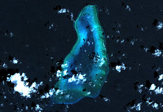
Blenheim Reef is a partly submerged atoll structure in the Chagos Archipelago, Indian Ocean. It includes the coral reef of Baxio Predassa in its southeastern rim, plus another completely submerged part. It is located in the northeastern part of the Chagos Archipelago. It measures almost eleven kilometres (north–south) by more than four kilometres (east–west), with a total area of 36.8 square kilometres, including the lagoon of 8.5 km², the difference being accounted for the mostly by the reef flat. Only on the eastern side, there are a few sand cays above the water. The largest of them is East Island, which is not quite 200 metres long and 70 metres wide. The other islands in the group are North, Middle and South. Only a few grasses grow on the island. The lagoon is up to 18 metres deep and encumbered with rock. The fringing coral reef has a wide passage in the southwest. The closest land is Takamaka Island in the Salomon Islands Atoll, about 20 kilometres to the southwest.

Great Chagos Bank

The Great Chagos Bank, in the Chagos Archipelago, about 500 km (310 mi) south of Maldives, is the largest atoll structure in the world, with a total area of 12,642 km2 (4,881 sq mi). The atoll is administered by the United Kingdom through the British Indian Ocean Territory (BIOT).

Benares Shoals

Benares Shoals, or Benares Shoal, is a submerged coral reef, an isolated patch located at 5°15′S071°40′E, just 6 kilometres (3.7 mi) west-northwest of Île Pierre, the closest island of Peros Banhos atoll in the northern Chagos Archipelago. It measures about 3 kilometres (2 mi) east–west, with a width of about 700 metres (2,300 ft) and an area of 2 square kilometres (0.77 sq mi). The least depth at the western end is 4.5 metres (15 ft).

Expulsion of the Chagossians

The deportation of Chagossians from the Chagos Archipelago was the forced expulsion of the inhabitants of the island of Diego Garcia and the other islands of the British Indian Ocean Territory (BIOT) by the United Kingdom, at the request of the United States, beginning in 1968 and concluding on 27 April 1973 with the evacuation of Peros Banhos atoll. The people, known at the time as the Ilois, are today known as Chagos Islanders or Chagossians.

British Indian Ocean Territory British overseas territory in South Asia

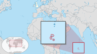
The British Indian Ocean Territory (BIOT) is a British overseas territory of the United Kingdom situated in the Indian Ocean halfway between Tanzania and Indonesia. The territory comprises the seven atolls of the Chagos Archipelago with over 1,000 individual islands – many very small – amounting to a total land area of 60 square kilometres (23 sq mi). The largest and most southerly island is Diego Garcia, 27 km2 (10 sq mi), the site of a joint military facility of the United Kingdom and the United States.

Kadmat Island Village in India

Kadmat Island, also known as Cardamom Island, is a coral island belonging to the Amindivi subgroup of islands of the Lakshadweep archipelago in India. Measuring 9.3 kilometres (5.8 mi) in length, the island has a lagoon with a width of 1.5 kilometres (0.93 mi) covering an area of 25 square kilometres (9.7 sq mi). The ecological feature of the island is of coral reef with seagrass, and marine turtles which nestle here. The Ministry of Environment and Forests (India) has notified the island as a marine protected area for ensuring conservation of the island's animal, plant, or other type of organism, and other resources.

Petite Ile Bois Mangue

Petite Île Bois Mangue is a 9 ha island on the Peros Banhos Atoll in the Chagos Archipelago of the British Indian Ocean Territory. It is part of the Peros Banhos strict nature reserve and has been identified as an Important Bird Area by BirdLife International because of its significance as a breeding site for lesser noddies, of which 12,000 pairs were recorded in a 2004 survey.

The Chagos Marine Protected Area, located in the central Indian Ocean in the British Indian Ocean Territory of the United Kingdom, is one of the world's largest marine protected areas, and one of the largest protected areas of any type on Earth. It was established by the British government on 1 April 2010 as a massive, contiguous, no-take marine reserve, it encompasses 640,000 square kilometres (250,000 sq mi) of ocean waters, including roughly 70 small islands and seven atolls of the Chagos Archipelago.

References

  1. Notholt 2008, p. 5.
  2. 1 2 3 "British Indian Ocean Territory". WorldAtlas.com. Retrieved 23 June 2013.
  3. 1 2 3 4 5 6 7 "British Indian Ocean Territory". Encyclopædia Britannica. Retrieved 23 June 2013.
  4. 1 2 3 Central Intelligence Agency 2010, p. 93.
  5. 1 2 Haggett 2001, p. 2627.
  6. Green 2006, p. 408.
  7. Paul 1987, p. 146.
  8. "Blue Reef visitors win support for the Chago campaign". BBC . Retrieved 23 May 2013.
  9. "Chagos Island Marine Reserve". Marine Conservation Society (UK) SouthEast. Archived from the original on 21 March 2012. Retrieved 23 June 2013.
  10. Acton 2012, p. 524.
  11. "Diego García inscrito en la Lista de Ramsar / Diego Garcia, atoll de l'océan Indian, inscrit sur la liste de Ramsar" (in Spanish). Ramsar. 8 October 2001. Archived from the original on 7 July 2013. Retrieved 1 July 2013.
  12. Vine 2011, p. 22.
  13. World Wildlife Fund, ed. (2001). "Maldives-Lakshadweep-Chagos Archipelago tropical moist forests". WildWorld Ecoregion Profile. National Geographic Society. Archived from the original on 8 March 2010.
  14. Natural Resources Management Plan (2005), paragraph 2.5.1.
  15. Natural Resources Management Plan (2005), paragraph 3.3.2.1.
  16. "Mauritius stakes claim for Chagos". BBC. 30 March 2004. Retrieved 23 June 2013.
  17. 1 2 Tuckey 1815, pp. 64–65.
  18. British Admiralty nautical chart 11000030 – 3 Chagos Archipelago, Scale 1:360,000
  19. Evers & Kooy 2011, p. 27.
  20. Paul 1987, p. 14.
  21. Dupont 2001, p. 1120.
  22. Olson & Shadle 1991, p. 90.
  23. Russell 2012, p. 269.

Bibliography