Related Research Articles

Oakland is the most populous city and the county seat of Alameda County, California, United States. A major West Coast port, Oakland is the largest city in the East Bay region of the San Francisco Bay Area, and the third-largest city overall in the Bay Area. With a population of 440,646 in 2020, it serves as the Bay Area's trade center: the Port of Oakland is the busiest port in Northern California, and the fifth- or sixth-busiest in the United States. A charter city, Oakland was incorporated on May 4, 1852.

A skid row, also called skid road, is an impoverished area, typically urban, in English-speaking North America whose inhabitants are mostly poor people "on the skids". This specifically refers to people who are poor or homeless, considered disreputable, downtrodden or forgotten by society. A skid row may be anything from an impoverished urban district to a red-light district to a gathering area for people experiencing homelessness or drug addiction. In general, skid row areas are inhabited or frequented by impoverished individuals and also people who are addicted to drugs. Urban areas considered skid rows are marked by high vagrancy, dilapidated buildings, and drug dens, as well as other features of urban blight. Used figuratively, the phrase may indicate the state of a poor person's life.
Lamorinda is an area within Contra Costa County, California in the United States. The name is a portmanteau from the names of the three cities that make up the region: Lafayette, Moraga and Orinda.
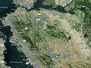
The East Bay is the eastern region of the San Francisco Bay Area and includes cities along the eastern shores of the San Francisco Bay and San Pablo Bay. The region has grown to include inland communities in Alameda and Contra Costa counties. With a population of roughly 2.5 million in 2010, it is the most populous subregion in the Bay Area.
The Golden Gate neighborhood of Oakland, California is located in the northwest corner of the city, east of Emeryville and south of Berkeley. It includes the Golden Gate Shopping District, the stretch of San Pablo Avenue between 53rd Street on the south, and the Oakland-Berkeley border at 67th Street to the north. The neighborhood includes the area from a few blocks west of San Pablo Avenue to Adeline Street on the east.

West Oakland is a neighborhood situated in the northwestern corner of Oakland, California, United States, situated west of Downtown Oakland, south of Emeryville, and north of Alameda. The neighborhood is located along the waterfront at the Port of Oakland and at the eastern end of the San Francisco–Oakland Bay Bridge. It lies at an elevation of 13 feet.

Maxwell Park is a neighborhood in Oakland, California located in the foothills of the city. It is geographically bordered by MacArthur Boulevard, High Street, Trask Street, Foothill Boulevard, and 55th Avenue and is adjacent to Mills College, I-580, Brookdale Park, and the Fairfax neighborhood. It lies at an elevation of from 138 feet to its highest point of 266 feet on Knowland Ave.
Oakland City Center is an office, shopping and hotel complex in Downtown Oakland, Oakland, California. The complex is the product of a redevelopment project begun in the late 1950s. It covers twelve city blocks between Broadway on the east, Martin Luther King Jr. Way on the west, Frank H. Ogawa Plaza on 14th Street on the north side of the complex and the Oakland Convention Center and Marriott Hotel extend south to 10th Street. An hourly parking garage is located beneath the complex's shopping mall. The mall features an upscale fitness and racquet club, in addition to numerous take-out restaurants and other stores. The complex is served by the 12th Street/Oakland City Center BART station.

Rincon Hill is a neighborhood in San Francisco, California. It is one of San Francisco's many hills, and one of its original "Seven Hills". The relatively compact neighborhood is bounded by Folsom Street to the north, the Embarcadero to the east, Bryant Street on the south, and Essex Street to the west. Named after Rincon Point that formerly extended into the bay there, Rincon Hill is located just south of the Transbay development area, part of the greater South of Market area. The hill is about 100 feet tall.

Hilltop District, more commonly known simply as Hilltop, is a neighborhood located in the northeastern area of Richmond, California.

Richmond Heights, formerly East Richmond and also known as Mira Vista, is a district of eastern Richmond, California in the San Francisco Bay Area.

Downtown Oakland is the central business district of Oakland, California, United States. It is located roughly bounded by both the Oakland Estuary and Interstate 880 on the southwest, Interstate 980 on the northwest, Grand Avenue on the northeast, and Lake Merritt on the east.
Sobrante Park is a neighborhood located in East Oakland, California, which is partially separated from the rest of the city by two railroad tracks and San Leandro Creek. It was built shortly after World War II, first as a White-Only Lockout and then gradually becoming a White flight red-zone in the mid to late 1950s, and in the early 1960s it became a working-class black neighborhood. It was projected by planners that there would be no in-road into San Leandro's Davis St. residential area which was developed during the same period.

Uptown Oakland is a neighborhood in Oakland, California, located in the northern end of Downtown. It is located roughly between West Grand Avenue to the north, Interstate 980 to the west, City Center and 14th Street to the south, and Broadway to the east. The neighborhood has become an important entertainment district in recent years.
Acorn or Acorn Projects are a series of housing projects in the Acorn Redevelopment Project Area or the Acorn neighborhood of West Oakland. Acorn, also known as "The Corns" or the "Cornfields", neighbors a wide variety of public housing. It is bordered by the high rise City Towers Apartments and low rise Mohr Apartments to the South, Cypress Village to the West, Market Street to the east and 10th Street to the north.
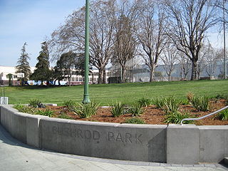
The Bushrod neighborhood in North Oakland, Oakland, California is an area surrounding its namesake park, and bounded by Martin Luther King, Jr. Way to the west, Claremont Avenue to the east, Highway 24 to the south, and the Berkeley border to the north. It borders the neighborhoods of Santa Fe to the west, Fairview Park to the east, and Temescal and Shafter to the south and southeast, respectively. Notable landmarks include the Bushrod Park ballfields and the former Bushrod Washington Elementary School, which share adjoining land on a large greenbelt and open space in the heart of the neighborhood.
San Antonio is a large district in Oakland, California, encompassing the land east of Lake Merritt to Sausal Creek. It is one of the most diverse areas of the city. It takes its name from Rancho San Antonio, the name of the land as granted to Luís María Peralta by the last Spanish governor of California.
The Cypress Village housing projects are a series of housing complexes stretching from 10th Street to 14th Street and Kirkham Way. Cypress is located in between the Acorn neighborhood and Lower Bottoms neighborhood in West Oakland. Cypress Village is one of the three housing projects in West Oakland, along with the Campbell Village Court and the Acorn Projects.

The history of Oakland, a city in the county of Alameda, California, can be traced back to the founding of a settlement by Horace Carpentier, Edson Adams, and Andrew Moon in the 19th century. The area now known as Oakland had seen human occupation for thousands of years, but significant growth in the settlements that are now incorporated into the city did not occur until the Industrial Revolution. Oakland was first incorporated as a town in 1852.
References
- 1 2 3 Ostler, Scott (June 22, 2007). "Baseball Brings Life: Boy's death spurs Oakland couple to save neighborhood kids one game at a time". The San Francisco Chronicle. Archived from the original on 10 April 2021. Retrieved 24 May 2023.
- 1 2 3 Dan Antonioli. "A Short History of Ghost Town". Archived from the original on 2007-12-11. Retrieved 2007-09-25.
- ↑ "Time Out reveals the world's 40 coolest neighbourhoods right now". Time Out. 6 October 2020. Retrieved 24 May 2023.
- ↑ Hatfield, Larry D. (July 9, 1998). "Oakland nabs drug suspects". The San Francisco Chronicle. Retrieved 2007-09-25.
- 1 2 Matier, Phillip; Ross, Andrew (January 24, 2001). "'Ghost Town' a Work in Progress". The San Francisco Chronicle. Retrieved 2007-09-25.
- ↑ Heredia, Christopher (May 27, 2007). "Eyes, ears, feet on streets; Citizen groups gather to patrol neighborhoods, help law enforcement". The San Francisco Chronicle. Retrieved 2007-09-25.
- ↑ DeFao, Janine; Zamora, Jim Herron (October 9, 2005). "Dellums may face big reality check". The San Francisco Chronicle. Retrieved 2007-09-25.
- ↑ ."The hip list: best, worst of '06", Contra Costa Times , December 26, 2006. Accessed October 20, 2007.
- ↑ Farhi, Paul. "Ghost-Riding: Brake-Dancing With Zip Under the Hood", The Washington Post , December 27, 2006, p. C01. Accessed October 18, 2007.
- 1 2 "Programs for families and children". City of Oakland, Department of Human Services. Archived from the original on 2007-08-08. Retrieved 2007-09-25.