Gladwin County, Michigan

Last updated

Gladwin County
Gladwin County Courthouse (Michigan).jpg
Gladwin County Courthouse in Gladwin
Gladwin County mi seal.png
Map of Michigan highlighting Gladwin County.svg
Location within the U.S. state of Michigan
Michigan in United States.svg
Michigan's location within the U.S.
Coordinates: 43°59′N84°23′W / 43.99°N 84.39°W / 43.99; -84.39
CountryFlag of the United States.svg United States
StateFlag of Michigan.svg  Michigan
Founded1831 (created)
1875 (organized) [1]
Named for Henry Gladwin
Seat Gladwin
Largest cityGladwin
Area
  Total516 sq mi (1,340 km2)
  Land502 sq mi (1,300 km2)
  Water14 sq mi (40 km2)  2.7%
Population
 (2020)
  Total25,386
  Density51/sq mi (20/km2)
Time zone UTC−5 (Eastern)
  Summer (DST) UTC−4 (EDT)
Congressional district 2nd
Website www.gladwinco.com

Gladwin County is a county located in the U.S. state of Michigan. As of the 2020 Census, the population was 25,386. [2] The county seat is Gladwin. [3]

Contents

History

Prehistory

Gladwin County is a headwaters area. Most of the water that flows out of the county via the Tittabawassee River comes from Gladwin County, only a very small portion flows in from Clare or Roscommon counties. Native Americans crossed this area, and even spent summers here where the fishing was good and summer berries plentiful.

Research is underway to determine the importance of an ancient trail that was noted by the crew of the 1839 re-survey of Township 17 north Range 2 west, which later became Beaverton Township. The eastern terminus of the "Muskegon River Trail" was plotted at the confluence of the three branches of the Tobacco (Assa-mo-quoi-Sepe) River in the northwest corner of Section 12. It is possible that an early cross-country route from Saginaw Bay to Lake Michigan proceeded up the Saginaw, Tittabawassee, and Tobacco Rivers to a point west across Ross Lake from the Beaverton City Cemetery. At that point, the canoes would be portaged along the trail to the Muskegon River, then floated down to Lake Michigan.

Many native artifacts have been found along that route that attest to seasonal occupation, but so far no signs have been found to indicate a permanent settlement.

European arrival

The earliest documented visitors to the area were surveyors who platted the lands under provision of the 1787 Northwest Ordinance. Most of the early work was completed during the 1830s, although some of the survey work was faulty - the surveyors reportedly doubted that the area would ever be settled.

The earliest census to mention residents in the area was in 1860.

The county is named for Henry Gladwin, [4] British military commandant at Detroit in 1763 during Pontiac's War. The county was set off and named in 1831, and its government was organized in 1875. [1]

Sesquicentennial

The year 2011 marked 150 years since the first permanent settler of record, Marvel Secord, took up residence along the Tittabawassee River in what is now Secord Township. He was a trapper and trader who provided supplies to lumbering camps in the area. Another man, William Brayton, may have been an earlier settler; the 1860 census listed 14 residents, including two families with children. Of these, 11 were associated with lumbering camps that had begun to appear that year, and three were listed as "hunters." One of the "day laborers" at a camp had brought his wife to the area. The first issue of the Gladwin County Record (1878) mentions his 20 acres (8.1 hectares) of wheat under cultivation. His stepson, Dr. Russell E. Finch arrived in the area in 1875, becoming the county's first physician. William Brayton died in 1895. His claim to being the first permanent settler appears valid, except that just before the 1880 census was taken he and his wife went to Lynn, Massachusetts to care for his dying father. He returned to Gladwin after settling his father's estate in 1882, thus missing being included in the Gladwin County census for 1880.

Geography

According to the U.S. Census Bureau, the county has a total area of 516 square miles (1,340 km2), of which 502 square miles (1,300 km2) is land and 14 square miles (36 km2) (2.7%) is water. [5] It is the second-smallest county in Michigan by total area. Gladwin County is sometimes considered to be a part of Central Michigan, and at other times is included in Northern Michigan.

Major highways

County designated highways

Adjacent counties

Demographics

Historical population
CensusPop.Note
1880 1,127
1890 4,208273.4%
1900 6,56456.0%
1910 8,41328.2%
1920 8,8274.9%
1930 7,424−15.9%
1940 9,38526.4%
1950 9,4510.7%
1960 10,76913.9%
1970 13,47125.1%
1980 19,95748.1%
1990 21,8969.7%
2000 26,02318.8%
2010 25,692−1.3%
2020 25,386−1.2%
2023 (est.)25,853 [6] 1.8%
US Decennial Census [7]
1790-1960 [8] 1900-1990 [9]
1990-2000 [10] 2010-2018 [2]

As of the 2000 United States Census, [11] of 2000, there were 26,023 people, 10,561 households, and 7,614 families in the county. The population density was 51 people per square mile (20 people/km2). There were 16,828 housing units at an average density of 33 per square mile (13/km2). The racial makeup of the county was 97.65% White, 0.13% Black or African American, 0.56% Native American, 0.27% Asian, 0.02% Pacific Islander, 0.31% from other races, and 1.06% from two or more races. 0.96% of the population were Hispanic or Latino of any race. 28.1% were of German, 11.5% American, 11.1% English, 9.4% Irish, 7.3% Polish and 6.4% French ancestry according to Census 2000. 96.3% spoke English, 1.7% German and 1.1% Spanish as their first language.

There were 10,561 households, out of which 27.10% had children under the age of 18 living with them, 60.50% were married couples living together, 8.00% had a female householder with no husband present, and 27.90% were non-families. 24.00% of all households were made up of individuals, and 11.20% had someone living alone who was 65 years of age or older. The average household size was 2.43 and the average family size was 2.85.

The county population contained 23.20% under the age of 18, 6.50% from 18 to 24, 24.20% from 25 to 44, 27.80% from 45 to 64, and 18.30% who were 65 years of age or older. The median age was 42 years. For every 100 females there were 98.50 males. For every 100 females age 18 and over, there were 95.30 males.

The median income for a household in the county was $32,019, and the median income for a family was $37,090. Males had a median income of $33,871 versus $21,956 for females. The per capita income for the county was $16,614. About 10.40% of families and 13.80% of the population were below the poverty line, including 19.40% of those under age 18 and 7.30% of those age 65 or over.

Government

Gladwin County has been reliably Republican from the beginning. Since 1884, the Republican Party nominee has carried the county vote in 85% of the elections (29 of 35 elections).

United States presidential election results for Gladwin County, Michigan [12] [13]
Year Republican Democratic Third party
No.%No.%No.%
2020 9,89367.69%4,52430.95%1981.35%
2016 8,12464.77%3,79430.25%6244.98%
2012 6,66152.94%5,76045.78%1621.29%
2008 6,39148.27%6,59049.77%2601.96%
2004 6,77051.18%6,34347.95%1140.86%
2000 5,74349.39%5,57347.92%3132.69%
1996 3,67034.32%5,49451.38%1,52814.29%
1992 3,61633.56%4,45741.36%2,70325.08%
1988 4,74652.82%4,16446.34%760.85%
1984 5,40161.07%3,36838.08%750.85%
1980 4,50951.09%3,73342.30%5836.61%
1976 3,79450.14%3,71949.15%540.71%
1972 3,48461.94%2,01635.84%1252.22%
1968 2,84056.55%1,66833.21%51410.23%
1964 1,94141.45%2,72558.19%170.36%
1960 3,28269.65%1,42430.22%60.13%
1956 3,12173.47%1,11726.29%100.24%
1952 3,03175.85%93623.42%290.73%
1948 2,06266.43%96331.02%792.55%
1944 2,45770.93%98528.44%220.64%
1940 2,74167.78%1,29432.00%90.22%
1936 1,64549.21%1,53345.86%1654.94%
1932 1,37843.86%1,66152.86%1033.28%
1928 1,79583.76%34115.91%70.33%
1924 1,90878.36%25510.47%27211.17%
1920 1,68778.68%31314.60%1446.72%
1916 93552.88%72941.23%1045.88%
1912 63839.07%33120.27%66440.66%
1908 1,16871.35%38623.58%835.07%
1904 1,09379.49%23116.80%513.71%
1900 97875.23%29923.00%231.77%
1896 74867.09%32328.97%443.95%
1892 53160.76%32537.19%182.06%
1888 52558.79%35739.98%111.23%
1884 28855.49%21341.04%183.47%

The county government operates the jail, maintains rural roads, operates the major local courts, records deeds, mortgages, and vital records, administers public health regulations, and participates with the state in the provision of social services. The county board of commissioners controls the budget and has limited authority to make laws or ordinances. In Michigan, most local government functions — police and fire, building and zoning, tax assessment, street maintenance, etc. — are the responsibility of individual cities and townships.

Elected officials

(information as of 2024)

Communities

U.S. Census data map showing local municipal boundaries within Gladwin County. Shaded areas represent incorporated cities. Gladwin County, MI census map.png
U.S. Census data map showing local municipal boundaries within Gladwin County. Shaded areas represent incorporated cities.

Cities

Civil townships

Unincorporated communities

Ghost town

Education

The Clare-Gladwin Regional Education Service District, based in Clare, services the students in the county along with those of Clare County. The intermediate school district offers regional special education services, early education and after-school programs, and technical career pathways for students of its districts. [15]

Gladwin County is served by the following regular public school districts: [16]

Gladwin County has the following private schools: [17]

See also

Related Research Articles

<span class="mw-page-title-main">Ogemaw County, Michigan</span> County in Michigan, United States

Ogemaw County is a county located in the U.S. state of Michigan. As of the 2020 census, the population was 20,770. The county seat is West Branch.

<span class="mw-page-title-main">Midland County, Michigan</span> County in Michigan, United States

Midland County is a county located in the U.S. state of Michigan. As of the 2020 census, the population was 83,494. The county seat is Midland. The county's name is due to its closeness to the geographical Lower Peninsula's geographical center. It was founded in 1831. However, it was not until 1855 that the county was effectively organized.

<span class="mw-page-title-main">Isabella County, Michigan</span> County in Michigan, United States

Isabella County is a county located in the U.S. state of Michigan. As of the 2020 Census, the population was 64,394. Its county seat is Mount Pleasant. The area was known as Ojibiway Besse, meaning "the place of the Ojibwa". Isabelle County contains the Isabella Indian Reservation, on which members of the Saginaw Chippewa Tribal Nation live.

<span class="mw-page-title-main">Clare County, Michigan</span> County in Michigan, United States

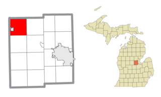
Clare County is a county in the U.S. state of Michigan. As of the 2020 Census, the population was 30,856. The county seat is Harrison.

<span class="mw-page-title-main">Arthur Township, Michigan</span> Civil township in Michigan, United States

Arthur Township is a civil township of Clare County in the U.S. state of Michigan. The township population was 676 at the 2020 census.

<span class="mw-page-title-main">Franklin Township, Clare County, Michigan</span> Civil township in Michigan, United States

Franklin Township is a civil township of Clare County in the U.S. state of Michigan. The population was 730 at the 2020 census.

<span class="mw-page-title-main">Hamilton Township, Clare County, Michigan</span> Civil township in Michigan, United States

Hamilton Township is a civil township of Clare County in the U.S. state of Michigan. The population was 1,785 at the 2020 census.

<span class="mw-page-title-main">Beaverton, Michigan</span> City in Michigan, United States

Beaverton is a city in Gladwin County in the U.S. state of Michigan. The population was 1,145 at the 2020 census. The city is bordered by Beaverton Township on the west, but the two are administered autonomously.

<span class="mw-page-title-main">Billings Township, Michigan</span> Civil township in Michigan, United States

Billings Township is a civil township of Gladwin County in the U.S. state of Michigan. As of the 2010 census, the township population was 2,416.

<span class="mw-page-title-main">Bourret Township, Michigan</span> Civil township in Michigan, United States

Bourret Township is a civil township of Gladwin County in the U.S. state of Michigan. As of the 2010 census, the township population was 461.

<span class="mw-page-title-main">Buckeye Township, Michigan</span> Civil township in Michigan, United States

Buckeye Township is a civil township of Gladwin County in the U.S. state of Michigan. As of the 2010 census, the township population was 1,308.

<span class="mw-page-title-main">Butman Township, Michigan</span> Civil township in Michigan, United States

Butman Township is a civil township of Gladwin County in the U.S. state of Michigan. As of the 2010 census, the township population was 1,999.

<span class="mw-page-title-main">Hay Township, Michigan</span> Civil township in Michigan, United States

Hay Township is a civil township of Gladwin County in the U.S. state of Michigan. The population was 1,362 at the 2010 census.

<span class="mw-page-title-main">Secord Township, Michigan</span> Civil township in Michigan, United States

Secord Township is a civil township of Gladwin County in the U.S. state of Michigan. The population was 1,151 at the 2010 census.

<span class="mw-page-title-main">Sherman Township, Gladwin County, Michigan</span> Civil township in Michigan, United States

Sherman Township is a civil township of Gladwin County in the U.S. state of Michigan. The population was 1,043 at the 2010 census.

<span class="mw-page-title-main">Tobacco Township, Michigan</span> Civil township in Michigan, United States

Tobacco Township is a civil township of Gladwin County in the U.S. state of Michigan. The population was 2,566 at the 2010 census.

<span class="mw-page-title-main">Hope Township, Midland County, Michigan</span> Civil township in Michigan, United States

Hope Township is a civil township of Midland County in the U.S. state of Michigan. The population was 1,373 at the 2020 census.

<span class="mw-page-title-main">Warren Township, Michigan</span> Civil township in Michigan, United States

Warren Township is a civil township of Midland County in the U.S. state of Michigan. The population was 2,040 at the 2020 census. The township surrounds the city of Coleman, but the two are administered autonomously.

<span class="mw-page-title-main">Nester Township, Michigan</span> Civil township in Michigan, United States

Nester Township is a civil township of Roscommon County in the U.S. state of Michigan. The population was 262 at the 2020 census.

<span class="mw-page-title-main">Freeland, Michigan</span> Census-designated place & unincorporated community in Michigan, United States

Freeland is a census-designated place in Tittabawassee Township, Saginaw County in the U.S. state of Michigan. It is part of the Saginaw-Midland-Bay Metropolitan Area. As of the 2000 census, the CDP population was 5,147. The CDP covers an area in the central portion of Tittabawassee Township. The Freeland post office, ZIP code 48623, serves nearly the entire township, as well as portions of Midland and Williams townships to the north, Frankenlust and Kochville townships to the east, Thomas and Richland townships to the south, and Ingersoll Township to the west.

References

  1. 1 2 "Bibliography on Gladwin County". Clarke Historical Library, Central Michigan University . Retrieved January 19, 2013.
  2. 1 2 "State & County QuickFacts". U.S. Census Bureau. Retrieved September 15, 2021.
  3. "Find a County". National Association of Counties. Retrieved June 7, 2011.
  4. Gannett, Henry (1905). The Origin of Certain Place Names in the United States. Govt. Print. Off. p.  138.
  5. "2010 Census Gazetteer Files". US Census Bureau. August 22, 2012. Archived from the original on November 13, 2013. Retrieved September 21, 2014.
  6. "Annual Estimates of the Resident Population for Counties: April 1, 2020 to July 1, 2023". United States Census Bureau. Retrieved April 4, 2024.
  7. "US Decennial Census". US Census Bureau. Retrieved September 21, 2014.
  8. "Historical Census Browser". University of Virginia Library. Retrieved September 21, 2014.
  9. "Population of Counties by Decennial Census: 1900 to 1990". US Census Bureau. Retrieved September 21, 2014.
  10. "Census 2000 PHC-T-4. Ranking Tables for Counties: 1990 and 2000" (PDF). US Census Bureau. Retrieved September 21, 2014.
  11. "U.S. Census website". US Census Bureau. Retrieved January 31, 2008.
  12. US Election Atlas
  13. The leading "other" candidate, Progressive Theodore Roosevelt, received 549 votes, while Socialist candidate Eugene Debs received 85 votes, Prohibition candidate Eugene Chafin received 25 votes, and Socialist Labor candidate Arthur Reimer received 5 votes.
  14. Departments Gladwin County website (accessed 2 October 2018)
  15. "CGRESD: What do we do?". Clare-Gladwin Regional Education Service District . Retrieved July 14, 2023.
  16. National Center for Education Statistics. "Search for Public School Data: Gladwin County, MI". Institute of Education Sciences . Retrieved July 16, 2023.
  17. National Center for Education Statistics. "Search for Private Schools: Gladwin County, MI". Institute of Education Sciences. Retrieved July 16, 2023.

43°59′N84°23′W / 43.99°N 84.39°W / 43.99; -84.39