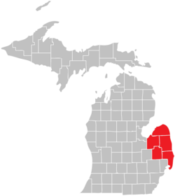
The counties that constitute the Thumb form the peninsula that stretches northward into Lake Huron and Saginaw Bay. There is no formal list of which counties are part of the Thumb, but virtually all definitions include Huron, Tuscola, and Sanilac counties, and most include Lapeer and St. Clair counties. The population of the Thumb region as of the 2020 census was 370,617.
The Thumb region is very flat with fertile soil, the reason for its historical role as a chiefly agricultural area. Major agricultural products include sugar beets, navy beans,[1]corn, fruits, and fish from Saginaw Bay and Lake Huron. Manufacturing—particularly concerning the automotive industry—is also prevalent in Michigan's Thumb due to the region's proximity to the automotive centers of Detroit and Flint.
Cargill Salt operates a large salt mine and factory in St. Clair. This is the only plant in the U.S.A. that produces Albergersalt, which is especially prized in the fast food industry because of its higher volume (due to its unique shape) and lower sodium content (for a given volume, not weight). This is part of Michigan's large salt-mining industry.
Cooperative Elevator Company has been named the top Michigan Agriculture Exporter by the Michigan Department of Agriculture.[2] Its headquarters are in Pigeon, and it has branch elevators in Deckerville, Akron, Gagetown, Sebewaing, Elkton, and Bad Axe.
SMR Automotive manufactures rear view mirrors at facilities in Port Huron and Marysville.[5]
Port Huron-based P.J. Wallbank Spring manufactures components for transmissions.[6]
Port Huron's industrial park is home to many companies that produce plastic components for vehicles, such as Prism Plastics,[7] Huron Plastics Group, and International Automotive Components.[8]
Michigan Ethanol, a partner of Broin Companies, operates a corn ethanol production facility in southwest Caro.
Dunn Paper is located at the mouth of the St. Clair River just north of the Blue Water Bridge and produces specialty papers.[11]
Keihin Michigan Manufacturing operates an auto part manufacturing plant in Capac, they build HVAC and intake manifold assemblies that are used in Honda vehicles.[12] The plant is scheduled to close in 2021.[13]
Champion manufactures small and mid size buses at their facility in Lapeer County's Imlay Township.
Star of the West Milling Co.[15] which has grain elevators in Vassar and Cass City, joined with Eastern Michigan Grain in Emmett.[16]
Huron Castings[17] produces shell molded steel castings in Pigeon.
Pigeon Telephone Co. has been meeting telecommunications needs of the rural communities it serves since 1908.[18]
Agri-Valley Services,[19] more commonly known as AVCI, is an internet service provider based out of Pigeon.
Thumb Cellular has been providing rural cellular service to the Thumb area since 1991.[20]
International Trade Corridor
The I-69 International Trade Corridor is a strategic commercial gateway between the Midwestern United States and Ontario, Canada, with multi-modal transportation infrastructure that offers a wide range of distribution options. The I-69 International Trade Corridor Next Michigan Development Corporation (NMDC) offers economic incentives to growing businesses, both existing and new, that utilize two or more forms of transportation to move their products and are located within the territory of the NMDC. The I-69 International Trade Corridor Next Michigan Development Corporation is the largest in the state of Michigan with 35 municipal partners.[21]
The Tip of The Thumb Heritage Water Trail is a nonprofit citizens organization working with the Huron County Parks to establish and maintain a water trail along Michigan's Lake Huron's shoreline.[23]
Harvest Wind Farm, an electrical generation project of Exelon Wind and Wolverine Power Supply Cooperative. Harvest II is scheduled for completion in December 2012.
Huron County Nature Center includes a 120-acre (0.49km2) wilderness arboretum that has been under the care of the Huron County Women's Clubs for more than 50 years.[25]
Kernan Memorial Nature Sanctuary is a 45-acre (180,000m2) refuge with 4,000 feet (1,200m) of shoreline acquired October 30, 1989 on Lake Huron, in Huron County. On the western coast of Whiskey Harbor, this area is a great place to see migratory birds in early March and November.[26]
The Sanilac Petroglyphs were discovered after massive fires swept the Lower Peninsula in 1881. Native Americans created this unusual artwork 300 to 1,000 years ago. The petroglyphs provide a glimpse into the lives of an ancient woodland people who occupied Michigan's Thumb area.
The Lake Huron Circle Tour is a designated scenic road system connecting all of the Great Lakes and the St. Lawrence River.[29] Many visitors choose to begin the circle tour in Port Huron, from which they can circle Lake Huron. M-25 winds around the Thumb and along Saginaw Bay to Saginaw and Bay City. Lexington and Port Austin feature beaches and boardwalks that are favorites with visitors.
Feast of the Sainte Claire sponsored by the Port Huron Museum of Arts and History, a large living reenactment of 18th century life—Memorial Day weekend, (Port Huron).
Huron County is located at the tip of the Thumb. The county is surrounded on three sides by water – Saginaw Bay and Lake Huron, and has over 90 miles (140km) of shoreline, from White Rock on Lake Huron to Sebewaing on Saginaw Bay, and more shoreline parks than any other county in the state.
The county's economy relies on agriculture and ranks as one of the top agricultural counties in Michigan. Rich farmland inland produces beans, sugar beets and grain, including most of the world's supply of navy beans.[38] Tourism is also important to Huron County with bay front and lakefront towns such as Sebewaing, Caseville, Port Austin, Port Hope, and Harbor Beach, attracting tourists from all over. Huron County borders Saginaw Bay and Lake Huron. There are two state parks – Sleeper State Park and Port Crescent State Park. Three roadside parks – Jenks Park, Brown Park, and White Rock Park. Also, Huron County maintains nine county parks along the shoreline, which are Caseville Park, Lighthouse Park, Stafford Park, McGraw Park, Philp Park, Port Austin Bird Creek Park, Wagener Park, Oak Beach Park, and Sebewaing Park. The county seat is Bad Axe, located in the center of the county.
Lapeer
The origin of the name of the county is often disputed, but it may have derived from the French words la pierre, meaning "the stone". This name could be a reference to the rounded stones, or flint pebbles, found in the rivers and streams throughout the area. Another theory is that it may be an English variation of Le Pays Plat, meaning "the flat land", which is one of the original names given to the area by the French, and can be found on many early fur trader maps of the area. The idea is that "Le Pays" may have evolved into the current pronunciation, "Lapeer".
Lapeer County is in many ways different from the other counties of the Thumb. First, it is heavily influenced by its proximity to Flint and Detroit, so as a result, its economy depends more heavily on manufacturing than the other counties of the region. Second, although agriculture is still a key economic factor in Lapeer County, it is not as important to the economy as in the other counties. Although there are still a few large-scale farms located in the county, the numbers are not found to the same extent, and these days, most farming in Lapeer now takes place on smaller, independent farms, which usually supply the local markets only. Lastly, in addition to its economic and agricultural differences, Lapeer County's geography is very different from the other counties of the Thumb. Its topography is generally gently rolling to quite hilly, and unlike its neighbors, which are flatter, and border on Lake Huron or Lake St. Clair, Lapeer County is landlocked. The county still has hundreds of acres of inland lakes such as Barnes Lake, Miller Lake, Lake Neppessing, the Holloway Reservoir, Big Fish Lake, and Lake Metamora, and several state recreation areas, including the Ortonville Recreation Area and the Metamora-Hadley Recreation Area, which still bring in many campers and tourists.
Sanilac
Sanilac County has the largest area of land in the Thumb. Like other counties, Sanilac has fertile and flat land, great for growing crops. Towns like Lexington and Port Sanilac bring in many tourists from the Detroit Area. Sandusky is the county seat and largest city.
St. Clair
St. Clair County has the largest population in the Thumb, and is considered part of the Metro Detroit MSA. Many residents farther north in the Thumb, especially Sanilac County, travel to Port Huron for shopping and work. It is the farthest county to the east in Michigan, and most of the eastern border is the St. Clair River, which separates Michigan from Ontario. For the most part, St. Clair County is flat with an agricultural economy dominating in the north and west; in the 19th century, agriculture and lumbering were important east to the St. Clair River. Sugar beets were cultivated and annual festivals were held at harvest time. In addition, many farms had mixed agriculture. There are steep hills and small canyons near the Black River. Since the mid-20th century, manufacturing had dominated in and around Port Huron.
Tuscola
Like Huron County, Tuscola is mostly dependent on agriculture. Industries such as sugar refining and ethanol processing, as well as growing various grains and beans, make up most of the economy. Caro, one of the largest cities in the Thumb (the largest if you exclude St. Clair and Lapeer counties), is named after Cairo, Egypt and is the county seat. Tuscola County only has 18 miles (29km) of shoreline along Saginaw Bay, so it is not as dependent on tourism as the other counties in the area. Tuscola County is economically tied to the surrounding region as well as to the Saginaw, Bay City, and Flint areas.
Borderline regions
The boundaries of what is included in the Thumb are often debated, but nearly all definitions include Huron, Sanilac, and Tuscola counties, known as the tri-county region. Disputed areas include:
St. Clair County, especially the southern portion, as the county is now classified as part of Metro Detroit by the Census Bureau.
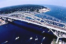
The Blue Water Area is another term describing the Thumb of Michigan. The term usually applies to St. Clair County and surrounding areas. The title is also extended to include all of Michigan's Thumb. The name refers to the county being bordered by water: on the east is the St. Clair River, connecting Lake Huron to the north to Lake St. Clair. Below that is the Detroit River. The namesake Blue Water Bridge spans the St. Clair River, connecting Port Huron to Sarnia, Ontario. A similar name, "Blue Water Country," is used to describe the same region on the Canadian side.
Discover the Blue
Discover the Blue is a promotion by the Blue Water Area Convention and Visitor's Bureau.[39] It is designed to attract visitors to the shoreline of eastern Michigan. Communities participating in Discover the Blue include Algonac in St. Clair County (at the southern end of the Thumb) and others to the north, such as Port Austin (at the tip of the Thumb).
The Thumb's landscape ranges from a flat sandy plain along the shores of Lake Huron and Saginaw Bay, to a gently rolling topography. This land is fertile and well suited for agriculture. The most unusual geographic formation is a rugged glacial moraine, known collectively as the Hadley Hills, which extends in a northeasterly direction through the center of the Thumb, from the southwestern portion of the peninsula.
The places with the highest elevation are all associated with the Hadley Hills, and are located in Lapeer County. They are: Pinnacle Point, at 1,262 feet (385m) and Kerr (Cemetery) Hill, at 1,258 feet (383m), both in Hadley Township; Mount Christie, at 1,251 feet (381m), in Metamora Township; and a point near Mayville, reaching up to 1,050 feet (320m) above sea level.
The lowest point in the Thumb region is the shore of Lake St. Clair, at a low of 574 feet (175m) above sea level.
Huron County is very flat. It has large fields that were used for agriculture and now are the sites of numerous wind turbines to generate electricity.
The north branch of the Flint River lies in northern Lapeer County. It rises near North Branch. The southern branch flows through the central and southern portion of Lapeer County, originates in Brandon, Atlas, Hadley, and Metamora townships before merging with the North Branch just north of the Holloway Reservoir.
History and local culture
Map of the Surveyed Part of the Territory of Michigan by Orange Risdon, 1825, showing an early, larger incarnation of Sanilac County, most of which had not yet been surveyed
Since the late 18th century, ethnic European Americans have displaced the Native American tribes that historically occupied this territory. Since the early 20th century, they have dominated the population and culture of the Thumb. The French were the first Europeans to arrive, and thus influenced much of the early culture. They were mostly engaged in the fur trading and lumber industries, and had relatively few settlers. After the British won the French and Indian War, they took over this former French territory.
Many of these new settlers were sent into the area by the British from Canada in an effort to establish their dominance over the Great Lakes. In 1783, control of the Thumb was officially transferred to the newly formed United States, after the American Revolution and by the Treaty of Paris. The British were a dominant influence until after the War of 1812, when the northern border was firmly defined and this area came under US control. The US organized the Northwest Territory, and American settlement of Michigan and the Thumb was well underway by the mid-19th century. Construction of the Erie Canal through Central New York created stronger connections with the port of New York and eastern markets. Settlers migrated west from New York and New England into Ohio and Michigan, seeking new territory.
As a result of this history, the land was settled primarily by people of ethnic English and Scots-Irish descent; many arrived from Canada. Other settlers of the same ancestry migrated from eastern states such as New York, and Pennsylvania, as well as from New England. Immigration from the British Isles took place through the century, and later 19th and 20th century residents included Polish and German immigrants who migrated from Europe through the Detroit area. Many of the customs, much of the regional lifestyle, and even the local accent, strongly reflect these origins. Some local radio stations have featured polka shows, and various ethnic festivals, such as the Polkafest, in Kinde, are representative of Eastern European cultures.
In the early years, Europeans encountered and traded with people of the Fox and Sauk tribes, already living in the area for centuries. There may have also been other tribes in the area such as the Potawatomi, Ojibwe, and Kickapoo, but they would have been transient tribes, or found in very small numbers. All native Thumb area tribes are members of the Algonquian peoples, a large language family. Other tribes who migrated later into the area included the Wyandot (Huron), an Iroquoian language-speaking people; and the Ottawa. The displacement of native peoples took place in many areas during the settling of North America.
Historical events
The Port Huron area is one of oldest European settlements in the state of Michigan, first settled by French colonists.
Colonial-era forts such as Fort Gratiot (north of Port Huron) and Fort Sinclair (near present-day St. Clair) were built along the St. Clair River.
Bad Axe was named so because Captain Rudolph Papst found an old axe in 1861, when he was clearing land for the present-day Huron County seat.
The great Thumb Fire took place on September 5, 1881, in the Thumb area of Michigan. The fire, which burned over a million acres (4,000km2) in less than a day, was the consequence of drought, hurricane-force winds, heat, the after-effects of the Port Huron Fire of 1871, and the ecological damage wrought by the era's logging techniques of clear cutting forests.
Thomas Edison – Inventor and entrepreneur settled in Port Huron from 1854 to 1863.
Obadiah Gardner – born in Port Huron, he moved to Maine as a child, where he lived and worked for the rest of his life, being elected as US Senator from Maine
32nd District – Northern Macomb and six townships in St Clair County.
Pamela Hornberger, Republican
81st District – Most of St Clair County, except Port Huron.
Gary Eisen, Republican
82nd District – All of Lapeer County.
Gary Howell, Republican
83rd District – City of Port Huron, the Townships of Fort Gratiot and Burtchville, and all of Sanilac County.
Andrew Beeler, Republican
84th District – All of Huron and Tuscola counties.
Phil Green, Republican
Michigan Senate
25th District – All of Huron, St Clair and Sanilac counties, and the Cities of Memphis, New Baltimore, and Richmond and the Townships of Armada and Richmond in Macomb County.
Dan Lauwers, Republican
31st District – All of Bay, Lapeer and Tuscola counties.
The Huron Daily Tribune[43] is a daily newspaper serving the "Upper Thumb Area of Michigan", which includes all of Huron and portions of Tuscola counties.
The Times Herald[44] is a daily newspaper headquartered in Port Huron and distributed in St. Clair and Sanilac counties. It is owned by the Gannett Company.
M-25 is a highway of an arc-like shape closely following the outline of the Thumb along the Lake Huron/Saginaw Bay shoreline between Port Huron and Bay City. It is generally a scenic drive.
M-46 is a cross peninsular road, running across the mitten and the Thumb—from Port Sanilac on the Lake Huron shore; through Saginaw near Saginaw Bay; and then on to Muskegon on the Lake Michigan shore.[50] This east-west surface route nearly bisects the Lower Peninsula of Michigan latitudinally.
M-53 (Van Dyke Road) is a gateway route to the Thumb of Michigan, carrying vacationers to the resorts and cottages on Saginaw Bay and Lake Huron in the vicinity of Caseville and Port Austin. It goes up the middle of the Thumb, and directly connects in Macomb County to the M-53 expressway. It is an important route for agricultural and manufactured goods.
The only international airport in the Thumb is St. Clair County International Airport about 6 miles (9.7km) outside Port Huron. City airports include: Caro Municipal, Dupont-Lapeer Airport, Huron County Memorial Airport, Marine City Airport, Marlette Municipal, Sandusky City, and Yale Airport. Scheduled airline service is available from MBS International Airport[51] in Freeland and Flint Bishop International Airport.[52] While neither of these airports is in the Thumb, both are relatively close by.
Area codes
Area code 989 covers about half of the Thumb: Huron, Tuscola, and far northern Sanilac County (and the Marlette area). The Thumb's other half is covered by area code 810, which takes in most of Sanilac, Lapeer, Genesee and Saint Clair counties. All of Macomb County is served by area code 586, as is a small part of south-western Saint Clair County.
Ackerman, Emma J. Thumb Fires of 1871 and 1881. CMU Term Paper, 1968.
DuMond, Neva. Thumb diggings; adventures into Michigan's Thumb area. Lexington, Mich, 1962.
The Great Fire of 1881: A Collection of Stories. Caro, MI: Tuscola County Advertiser, 1981.
Hatt, R. T. — The petroglyphs, by D. J. Richards. — An archeological survey of the petroglyph site, by M. Papworth (republished from the Michigan archeologist, Dec. 1957) The Sanilac petroglyphs. Bloomfield Hills, Michigan: Cranbrook Institute of Science, 1958
House Party: Reminiscences by Traditional Musicians and Square Dance Callers in Michigan's Thumb Area. Port Huron, MI: Museum of Arts and History, 1982.
Schultz, Gerard. A History of Michigan's Thumb.
Smith, Dee. Treks into the Past: Historical Sketches of Michigan's Thumb. Decatur, MI: Heritage Valley Publishing, 1989.
Southgate, Jerry D. Thumb's Forest Fire of 1881. Central Michigan University Term Paper, 1967.
Tuscola County is a county in the Thumb region of the U.S. state of Michigan. As of the 2020 census, the population was 53,323. The county seat is Caro. The county was created by Michigan Law on April 1, 1840, from land in Sanilac County and attached to Saginaw County for administrative purposes. The Michigan Legislature passed an act on March 2, 1850, that empowered the county residents to organize governmental functions.
St. Clair County is a county located in the U.S. state of Michigan and bordering the west bank of the St. Clair River. As of the 2020 census, the population was 160,383. It is the 13th-most populous county in the state. The county seat is Port Huron, located at the north end of the St. Clair River at Lake Huron. The county was created September 10, 1820, and its government was organized in 1821. It is located northeast of Detroit. It is considered by the State of Michigan to be a part of The Thumb, a peninsula that is surrounded by Lake Huron in the east-central area of the state. This area is sometimes dubbed the Blue Water Area.
Sanilac County is a county located in the Thumb region of the U.S. state of Michigan. As of the 2020 Census, the population was 40,611. The county seat is Sandusky. The county was created on September 10, 1822, and was fully organized on December 31, 1849. Sanilac County is considered to be part of the Thumb of Michigan, a subregion of the Flint/Tri-Cities. Sanilac County enjoys seasonal tourism in towns such as Lexington, Port Sanilac, and Carsonville. Sanilac County is economically attached to St. Clair County and Huron County and is largely composed of nearly flat areas of rich soil.
Huron County is a county in the U.S. state of Michigan. As of the 2020 Census, the population was 31,407. The county seat is Bad Axe. Huron County is at the northern tip of the Thumb, which is a sub region of Mid Michigan. It is a peninsula, bordered by Saginaw Bay to the west and Lake Huron to the north and east, and has over 90 miles (140 km) of shoreline, from White Rock on Lake Huron to Sebewaing on the Saginaw Bay. Huron County's most prominent industry is agriculture, as with most of the other Thumb counties. Huron County enjoys seasonal tourism from large cities such as Detroit, Flint, and Saginaw. Much of the tourism is in the Port Austin and Caseville area.
Port Huron is a city in the U.S. state of Michigan and the county seat of St. Clair County. The population was 28,983 at the 2020 census. The city is bordered on the west by Port Huron Township, but the two are administered autonomously.
M-25 is a state trunkline highway in the US state of Michigan. The route follows an arc-like shape closely along the Lake Huron shore of the Thumb in the eastern Lower Peninsula between Port Huron and Bay City. It serves the lakeshore resorts along Lake Huron and Saginaw Bay and generally lies within sight of the lake and the bay. All is surface road and generally scenic, except for the freeway segment near the junction with Interstate 75 (I-75) and connection into the US Highway 10 (US 10) freeway.
Southeast Michigan, also called southeastern Michigan, is a region in the Lower Peninsula of Michigan that is home to a majority of the state's businesses and industries as well as slightly over half of the state's population, most of whom are concentrated in Metro Detroit.
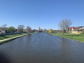
The Cass River is a 61.5-mile-long (99.0 km) river in the Thumb region of the U.S. state of Michigan. It drains large portions of Sanilac and Tuscola counties and smaller portions of Genesee, Huron, Lapeer, and Saginaw counties.
Area code 810 is a telephone area code in the North American Numbering Plan for the east-central part in the U.S. state of Michigan. The numbering plan area (NPA) comprises the cities of Flint, Lapeer, Port Huron, and the southern portion of the Thumb.
Central Michigan, also called Mid Michigan, is a region in the Lower Peninsula of the U.S. state of Michigan. As its name implies, it is the middle area of the Lower Peninsula. Lower Michigan is said to resemble a mitten, and Mid Michigan corresponds roughly to the thumb and palm, stretching from Michigan's eastern shoreline along Lake Huron into the fertile rolling plains of the Michigan Basin. The region contains cities of moderate size, including Flint, Saginaw, and the state capital of Lansing. Generally Central, or "Mid", Michigan is defined by governmental organizations as an area North of Jackson, and South of Clare.
Michigan's 8th congressional district is a United States congressional district in Central Michigan. The district was first created in 1873, after redistricting following the 1870 census. From 2003 to 2013, it consisted of all of Clinton, Ingham, and Livingston counties, and included the southern portion of Shiawassee and the northern portion of Oakland counties. From 2013 to 2023, the district no longer covered Clinton or Shiawassee counties and instead covered more of Oakland County, including Rochester. In 2023, the district was redrawn to be centered on the city of Flint, and includes all of Saginaw and Bay counties, almost all of Genesee County, and portions of Midland and Tuscola counties.
The Macomb Area Conference is a high school sports league located in Southeastern Michigan. It is a member of the Michigan High School Athletic Association (MHSAA). There are currently 36 members, spread across Macomb County, St. Clair County, Oakland County, and Wayne County.
The Tip of The Thumb Heritage Water Trails is a nonprofit citizens organization working with the Huron County Parks to establish and maintain a water trail along Michigan's Lake Huron's shoreline. It is dependent on public support for its existence and growth. The Water Trail, which is best utilized via sea kayaks by people who have had proper sea kayaking instruction, consists of camp sites and rest areas spaced out along the shore. The trail is still being developed, so there are several large sections with no public landing sites.
Huron and Eastern Railway is a short line railroad operating 394 miles (634 km) of track in The Thumb and Flint/Tri-Cities area of the lower peninsula of Michigan. It is currently owned by Genesee & Wyoming, Inc., who purchased it from RailAmerica in 2012. Its headquarters is in the former Michigan Central Railroad depot in Vassar, Michigan.
Water and Woods Field Service Council was a field service council of the Michigan Crossroads Council that served youth in the central and northeastern Lower Peninsula of Michigan. The Council was headquartered in Flint, Michigan, with service centers located in Auburn, Lansing, and Port Huron. The Water and Woods Field Service Council was the result of a merger in 2012 of Lake Huron Area Council, Blue Water Council, Tall Pine Council and Chief Okemos Council.
A wind chill advisory is a hazardous weather statement issued by Weather Forecast Offices (WFO) of the National Weather Service (NWS) in the United States to alert the public that wind chills are forecast to reach values low enough that it poses a threat to human health and life if adequate protection is not taken against hypothermia and frostbite. The exact criteria meriting the issuance of an advisory varies from state to state, and areas prone to colder temperatures will often require the wind chill to be lower before issuing an advisory.
A wind chill watch is issued by the National Weather Service of the United States when the wind chill could reach dangerous levels within the next 12 to 48 hours. The exact definition required to issue a watch varies from state to state or from National Weather Service county warning areas to another, but if forecasters believe conditions are favorable for life-threatening wind chills meeting local criteria, a watch will be issued. People going outside should plan to protect themselves against hypothermia and frostbite.
This page is based on this Wikipedia article Text is available under the CC BY-SA 4.0 license; additional terms may apply. Images, videos and audio are available under their respective licenses.