Glencorse

Last updated

Glencorse
Midlothian UK location map.svg
Red pog.svg
Glencorse
Location within Midlothian
Population5,293 
OS grid reference NT2470362607
Council area
Lieutenancy area
Country Scotland
Sovereign state United Kingdom
Post town Penicuik
Postcode district EH26
Dialling code 01968
Police Scotland
Fire Scottish
Ambulance Scottish
UK Parliament
Scottish Parliament
List of places
UK
Scotland
55°51′03″N3°12′15″W / 55.8507°N 3.2042°W / 55.8507; -3.2042

Glencorse is a parish of Midlothian, Scotland, lying 7 miles (11 kilometres) south of Edinburgh. [1] It is bounded on the north-west by the former parish of Colinton now within the City of Edinburgh, to the north and west by Lasswade and to the south and west by Penicuik.

Contents

The parish is in the northern part of the Penicuik and District Community Council area [2] and includes the village of Auchendinny near its eastern boundary. [3]

The parish is traversed from west to east by Glencorse Burn, part of whose valley contains Glencorse Reservoir, which was formed in 1819-28 by damming the burn's glen with a huge embankment 40 m (130 ft) high. [3] The reservoir is a source of Edinburgh's water supply. Also in the parish are Glencorse Barracks, Bush House, Glencorse House, Woodhouselee and Easter Howgate. The northern part of the parish includes some of the Pentland Hills and the highest point within the parish is Turnhouse Hill (428 m or 1,403 ft). [1] [4]

Historical records of the Parish before 1878 spell it in various different ways - Glencors, Glencrosss, Glencrosse and Glencorse. After 1878 the last was normally used. There are several theories about the origin of the name Glencorse. One is that it comes form the Gaelic gleann - a glen and grosg or craig, a crossing - so a glen crossing the Pentland hills. George Chalmers in his book "Caledonia" claims the name comes from "a very remarkable cross, which has been erected in the vale of Glencross by pious hands." Yet another theory is that the name comes from a miraculous cross that appeared above Carnethy hill and encouraged the Scottish soldiers to defeat the English forces at the Battle of Roslin in 1303. [5]

The parish is divided between two Scottish Parliamentary constituencies: Midlothian North and Musselburgh to the north of Glencorse burn and Midlothian South, Tweeddale and Lauderdale south of the burn. [6]

History

The parish was originally named after St. Catherine, because of the chapel (St. Catherine-in-the-Hopes) dedicated to her which stood in the valley of Glencorse Burn (now submerged under a reservoir) [7] and is mentioned in a record dated 1230. The parish of Glencorse was formed sometime before 1560 with the chapel of St. Catherine-in-the-Hopes as its church. Over the next century the parish was variously combined with the parishes of Dalkeith, Lasswade, Penicuik, Pentlands and the Bishopric of Edinburgh (In 1616, for example, it included the ancient parishes of Pentland and Penicuik, the northern part being taken from the parish of Pentland [Barony of Fulford] and the southern part from Penicuik) . In March 1647 Glencorse was re-created by act of Parliament as a separate Parish with its own church building near the centre of the parish. [5]

The Battle of Rullion Green between Covenanters and Scottish Government troops took place in 1666 in Glencorse Parish. The Covenanters were defeated. [8]

Glencorse Old Church (geograph 2174449) Glencorse Old Church (geograph 2174449).jpg
Glencorse Old Church (geograph 2174449)

The 1647 parish church was rebuilt. It was repaired and rebuilt several times from 1661 to 1691 [3] and then mostly destroyed in a fire in 1697. The church (now known as the Glencorse Old Kirk) was rebuilt in 1699 with the north and south aisles being added and accommodation for 180 people. [5] A tower and belfry were added to the church during renovations in 1811. [9] The author Robert Louis Stevenson attended services in the church in his youth when he lived in Swanston village nearby and once described the Old Kirk as the "most delightful place on earth." [10] Stevenson's letters to his friends often mention the Old Kirk and he used his memories as models for the churches in his books "A Lowder Sabbath Morning," " Weir of Hermiston " and " The Body Snatcher ." [5] Locally in Penicuik and Midlothian the Glencorse kirkyard was nicknamed "the Pirates Graveyard" due to the skull and crossbones on the graves despite this being a common feature on many graves.

The Old Kirk building acquired a new roof about 2004 [11] and, in 2021, was rented out for weddings and events, having been superseded for parish use by a much larger church. [12] The renovated church was used as a location for one of the scenes in Season 1 of the Outlander television series. [13] The Glencorse Old Kirk of Glencorse became too small for the parish due to the increased numbers of Royal Scots troops at Glencorse Barracks. The Minister at the time, the Rev. William Baillie Strong (1878-1928) was the driving force behind the building of a new church. The Rt. Hon. John Inglis offered a free site for the new church and funds to help with the construction. [5] Col. Robert Trotter, of Bush House also donated funds for a new building and a site to use as a cemetery, namely a field of about an acre at New Milton farm as the Old Kirk cemetery was full. The new church, designed by the architect Sir Rowand Anderson, was erected in 1885 and could seat 500 people. [5] The font was found in the floor of the Old Kirk during renovations in 1811 and is thought to have originally come from the Chapel of St Catherine, which was flooded during the creation of the Glencorse Reservoir. [14] The tower was erected 10 years after the main church using funds donated by John Inglis's son H.H. Inglis. [5]

A Parochial Board was established under the Poor Law (Scotland) Act 1845. With the Local Government (Scotland) Act 1894 the Parish Council was established, which continued until 1930 when parish councils in Scotland were abolished,. [15] Civil parishes persist for census and other non-administrative purposes.

The civil parish has an area of 4,245 acres [1] and a population of 5,293 (in 2011). [16]

Notable residents

Related Research Articles

<span class="mw-page-title-main">Midlothian</span> Council area of Scotland

Midlothian is a historic county, registration county, lieutenancy area and one of 32 council areas of Scotland used for local government. Midlothian lies in the east-central Lowlands, bordering the City of Edinburgh council area, East Lothian and the Scottish Borders.

<span class="mw-page-title-main">Penicuik</span> Town in Midlothian, Scotland

Penicuik is a town and former burgh in Midlothian, Scotland, lying on the west bank of the River North Esk. It lies on the A701 midway between Edinburgh and Peebles, east of the Pentland Hills.

<span class="mw-page-title-main">Coldingham</span> Village and parish in Scotland

Coldingham is a village and parish in Scottish Borders, on Scotland's southeast coastline, north of Eyemouth.

<span class="mw-page-title-main">River Esk, Lothian</span> River in Midlothian and East Lothian, Scotland

The River Esk, also called the Lothian Esk, is a river that flows through Midlothian and East Lothian, Scotland.

The Pentland Hills are a range of hills southwest of Edinburgh, Scotland. The range is around twenty miles in length, and runs southwest from Edinburgh towards Biggar and the upper Clydesdale.

<span class="mw-page-title-main">Lasswade</span> Human settlement in Scotland

Lasswade is a village and civil parish in Midlothian, Scotland, on the River North Esk, nine miles south of Edinburgh city centre, contiguous with Bonnyrigg and between Dalkeith to the east and Loanhead to the west. Melville Castle lies to the north east. The Gaelic form is Leas Bhaid, meaning the "clump at the fort."

<span class="mw-page-title-main">Rosewell, Midlothian</span> Village in Midlothian, Scotland

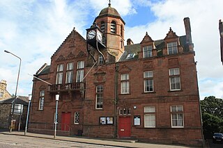
Rosewell is a former mining village in Midlothian, Scotland, east of Roslin and south-west of Bonnyrigg. The village is in the civil parish of Lasswade and was previously a separate ecclesiastical parish, but has its own Community Council, namely Rosewell and District.

<span class="mw-page-title-main">Glencorse Reservoir</span> Reservoir in Midlothian, Scotland

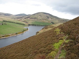
Glencorse Reservoir is a reservoir in Midlothian, Scotland, two miles west of Glencorse, in the Pentland Hills.

<span class="mw-page-title-main">Old Pentland Cemetery</span> Burial ground in Scotland

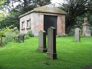
Old Pentland Cemetery is a cemetery in Old Pentland, near Loanhead in Midlothian, Scotland. A category B listed building, the cemetery dates back to the early 17th century.

<span class="mw-page-title-main">Caddonfoot</span> Village in Scottish Borders, Scotland, UK

Caddonfoot is a village on the River Tweed, in the Scottish Borders area of Scotland, on the A707, near Galashiels.

<span class="mw-page-title-main">Cockpen</span> Parish in Midlothian, Scotland

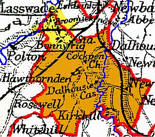
Cockpen is a parish in Midlothian, Scotland, containing at its north-west corner the town of Bonnyrigg, which lies two miles (3.2 km) south-west of Dalkeith. It is bounded on the west and north by the parish of Lasswade, on the east, by Newbattle and on the south by Carrington. It extends about three miles (4.8 km) from north to south and its greatest breadth is about 2+12 miles (4.0 km).

<span class="mw-page-title-main">Scoonie</span> Human settlement in Scotland

Scoonie is a settlement and parish in Fife, Scotland, the parish contains the town of Leven. It is bordered on the north by the parishes of Kettle and Ceres, on the east by the parish of Largo, on the south by the parishes of Markinch and Wemyss, and on the west by the parishes of Markinch and Kennoway. It extends about 4+12 miles north to south. Its width varies between 58 and 2+34 mi . The parish is on the coast of the Firth of Forth, with a coastline of about 1+12 mi (2.4 km) The area of the parish is 4,107 acres.

<span class="mw-page-title-main">Channelkirk</span> Human settlement in Scotland

Channelkirk is a parish and community council area in the north-west corner of the historic county of Berwickshire in the Scottish Borders area of Scotland, forming the upper part of the ancient district of Lauderdale, while the parish of Lauder forms the lower part. The Community Council has the name Oxton and Channelkirk, Oxton being the main village of the parish. It was formerly in the Ettrick and Lauderdale district of Borders Region. A small strip of land along the northern boundary of the parish was added to Ettrick and Lauderdale district and thus also to the community council area, in the Brothershiels area, in 1988.

<span class="mw-page-title-main">Cranston, Midlothian</span> Human settlement in Scotland

Cranston is a parish of Midlothian, Scotland, lying 4+14 miles south-east of Dalkeith. It is bounded by the parishes of Inveresk and Ormiston on the east, by Crichton and Borthwick on the south ; and by Newbattle on the west and north. The River Tyne flows through the centre of the parish.

Moonzie is a small parish in Fife, Scotland, about 3 miles north-west of Cupar. It is bounded on the west by Creich, on the north by Kilmany, on the south-east by Cupar and on the south-west by Monimail.

<span class="mw-page-title-main">Abdie</span> Human settlement in Scotland

Abdie is a parish in north-west Fife, Scotland, lying on the south shore of the Firth of Tay on the eastern outskirts of Newburgh, extending about 3 miles eastwards to the boundary of Dunbog parish, with which it is now united ecclesiastically and for the Community Council. It is also bounded by Collessie on the south and has a small border with the parish of Moonzie in the south-east.

<span class="mw-page-title-main">Cameron, Fife</span> Human settlement in Scotland

Cameron is a parish in east Fife, Scotland, 3½ miles south-west of St Andrews.

Manor is a parish in Peeblesshire in the Scottish Borders, whose church lies on the west bank of Manor Water 3 miles south-west of Peebles.

Old Pentland is a locality, former parish and former barony, in Midlothian, Scotland.

References

  1. 1 2 3 Gazetteer of Scotland, publ, by W & AK Johnston, Edinburgh, 1937. Article on Glencorse. Places are presented alphabetically
  2. Midlothian council web site https://midlothian.cmis.uk.com/live/CommunityCouncils.aspx - see entry for Penicuik and District. Retrieved April 2016
  3. 1 2 3 Gazetteer of Scotland, 2nd edition, by W. Groome, publ. 1896. Article on Glencorse
  4. The Statistical Account of Edinburghshire, by the Ministers of the Respective Parishes, publ. William Blackwood and Sons, Edinburgh, 1845. Article on Glencorse, p.310
  5. 1 2 3 4 5 6 7 Lunan, Murray; Lunan, Nora (1985). Brief History of the Church in Glencorse. Penicuik, Scotland: Penicuik Press. ISBN   0951095609.
  6. Midlothian Council Polling Station maps http://www.midlothian.gov.uk/info/802/voting/924/polling_stations (see map for Midlothian West) retrieved April 2016
  7. Topographical, Statistical, and Historical Gazetteer of Scotland (articles on Glencross and Pentland), publ. A. Fullarton & Co., Edinburgh, 1853
  8. Groome, Francis (1884). "Rullion Green Midlothian". Ordnance Gazetteer of Scotland / in A Vision of Britain through Time. Retrieved 30 August 2021.
  9. Reid, Alan (1903). "Glencorse Old Church and Churchyard". Proceedings of the Society of Antiquaries of Scotland. 38: 310. ISSN   2056-743X.
  10. "Old Parish Church, Glencorse, Penicuik, Midlothian". British Listed Buildings. 2013. Retrieved 7 December 2020.
  11. "Glencorse, Old Glencorse Kirk (LB7454)". Historic Environment Scotland. 22 January 1971. Retrieved 29 August 2021.
  12. The Architecture of Scottish post-Reformation churches, 1560-1843, by G. Hay, publ. Oxford, 1957, pp. 49-50
  13. "Outlander Film Locations" (PDF). Visit Scotland. Retrieved 7 December 2020.
  14. Historic Scotland’s web site for Listed Buildings http://portal.historic-scotland.gov.uk/designation/LB7456 retrieved April 2016
  15. Local Government (Scotland) Act 1929
  16. Census of Scotland 2011, Table KS101SC – Usually Resident Population, publ. by National Records of Scotland. Web site http://www.scotlandscensus.gov.uk/ retrieved March 2016. See “Standard Outputs”, Table KS101SC, Area type: Civil Parish 1930